 | The Scotia Sea gateway: No outlet for Pacific mantle |
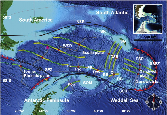
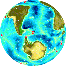
View of Scotia Sea consisting of the Scotia and Sandwich plates, located in between the Antarctic Peninsula and South America (see also insert map, where the red dot indicates the center of the top view map). The region is framed by transform boundaries in the north (North Scotia Ridge (NSR)), south (South Scotia Ridge (SSR)), west (Shackelton Fracture Zone (SFZ)), and the South Sandwich subduction zone (SSSZ) in the east. Other features are Shag Rocks (SR), South Georgia (SG), and the South Orkney Microcontinent (SOM). Flowlines displaying motion paths of different continental fragments are shown in green. Active spreading (East Scotia Ridge (ESR)) exists in the East Scotia Sea. Extinct spreading ridges are found in the West Scotia Sea (West Scotia Ridge (WSR)), Central Scotia Sea (Central Scotia Ridge (CSR) which remains controversial; see Subsection 2.2) and in the Protector (Pro), Dove (Dov), and Discovery Basins (Dis), respectively, which are bounded by presumably ЎЄ as some discussion on their origin persists ЎЄ South American continental fragments (Terror Rise (TR), Pirie Bank (PB), Discovery Bank (DB)). Extinct ridges are also found on the boundary between the Antarctic plate and former Phoenix plate as well as in the Powell Basin (Pow). Location of the dredge sample with Pacific mantle type signature (Pearce et al., 2001) [see discussion] is marked by a triangle |
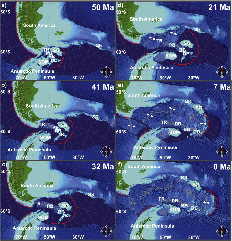
Tectonic reconstructions corresponding to 50 (a), 41 (b), 32 (c), 21 (d), 7 (e) and 0 Ma (f); labels as in Fig. 1; present-day bathymetry is shown (i.e. no age-masking). White/grey arrows indicate active/inactive spreading. 50 Ma ago, South America and Antarctica are connected by a coherent bridge of continental fragments. At 41 Ma, separation between South America and Antarctica and subduction behind Discovery Bank and South Georgia has started, as suggested by Barker (2001). Protector Basin has opened. 32 Ma ago, active spreading occurs along the West Scotia Ridge but has ceased in Dove Basin. At 21 Ma, further subduction behind Discovery Bank leads to opening of Discovery Basin. Moreover, subduction behind South Georgia is about to cause back-arc spreading in the Central Scotia Sea. Powell Basin is already fully open, placing the South Orkney Microcontinent to its present position relative to Antarctica. Seafloor spreading lasts along the West Scotia Ridge. 7 Ma ago spreading occurs along the West and East Scotia Ridges and ceases along the Central Scotia Ridge. |
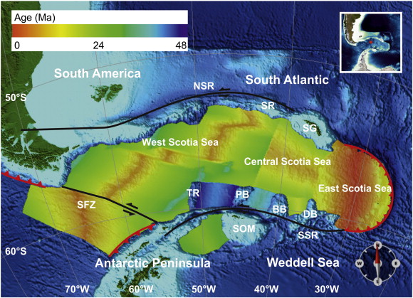
Synthetic age-grid based on the reconstruction model as shown in Fig. 2 |
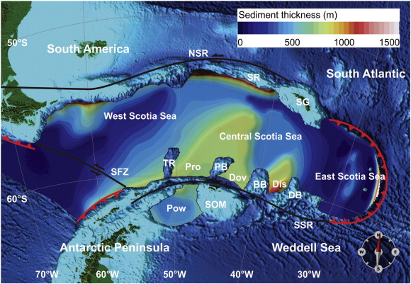
Sediment distribution in the Scotia Sea based on the 5 arc-minute by 5 arc-minute global grid that is available from the National Geophysical Data Center (NGDC). The sediment thickness is generally rather low (< 1000 m). Note that this also applies to the Central Scotia Sea but uncertainties exist |
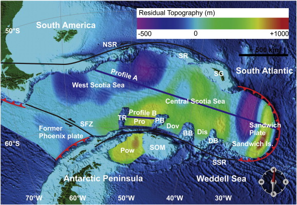
Present-day bathymetry with superimposed residual (dynamic) topography based on a half-space cooling model (Turcotte and Oxburgh, 1967). Note the regional low dynamic topography in the north-west and the high in the east. Note also the strong local dynamic topography signal associated with the subduction of the Scotia arc. The blue lines labeled Profile A and B indicate the location of the profiles illustrated in Fig. 6 and Fig. 7, respectively |
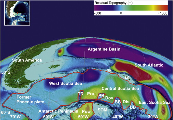
Northeast view from Antarctica. Note the large residual (dynamic) topography low (> 500 m Winterbourne et al., 2009) in the Argentine Basin (based on a half-space cooling model (Turcotte and Oxburgh, 1967)). |
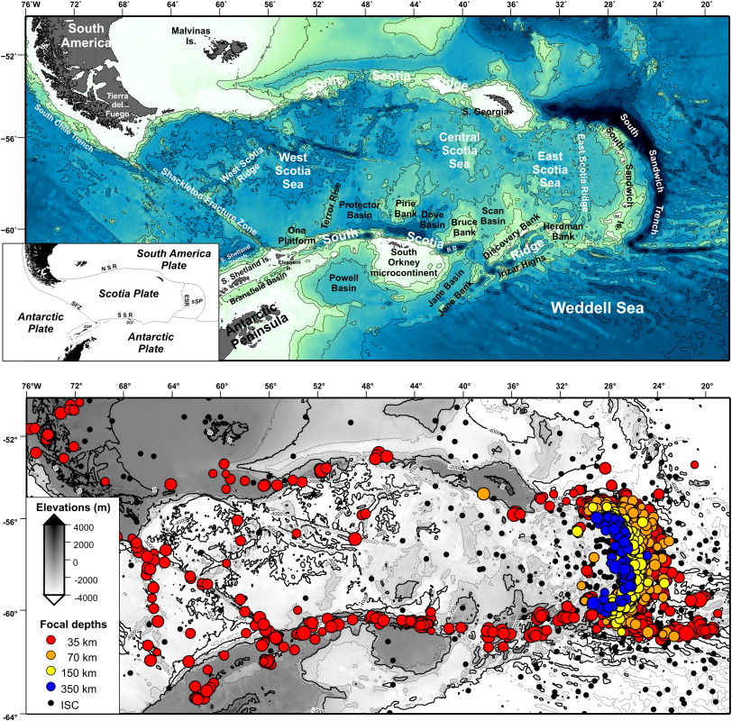
(top panel) Physiographic map of the Scotia Arc, with the main geological provinces discussed in the text. Bathymetric contours from satellite-derived data (Smith and Sandwell, 1997). Box shows the present-day plate tectonic sketch for the Scotia Sea and surrounding regions. NSR, North Scotia Ridge; SSR, South Scotia Ridge; ESR, East Scotia Ridge; SFZ, Shackleton Fracture Zone; BD, Bruce Deep; SSP, South Shetland plate; sSP, South Sandwich plate. (bottom panel) Distribution of earthquakes in the Scotia Arc region. Epicenters and focal depths are obtained from EHB Bulletin (Engdahl et al., 1998). EHB shallow (red), intermediate (orange and yellow), and deep (blue), earthquakes are shown as circles. Smaller black circles represent earthquakes located by ISC (http://www.isc.ac.uk).http://www.sciencedirect.com/science/article/pii/S0040195112002545 |
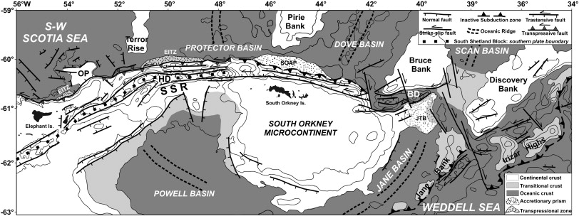
General tectonic map of the ScotiaбьбьCAntarctica plate boundary, from the Elephant Island to the Discovery Bank. SSR, South Scotia Ridge; OP, Ona Platform; SOAP, South Orkney accretionary prism; BD, Bruce Deep; HD, Hesperides Deep; JTB, Jane Thrust Belt; EITZ, Elephant Island transpressional zone |
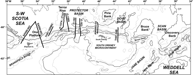
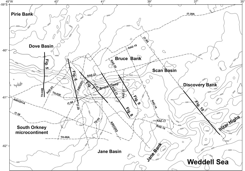
Index map showing the positions of seismic profiles presented in Fig. 4, Fig. 5, Fig. 6, Fig. 7, Fig. 8, Fig. 9, Fig. 10, Fig. 11 and Fig. 12. Line''s name indicates the corresponding figures |
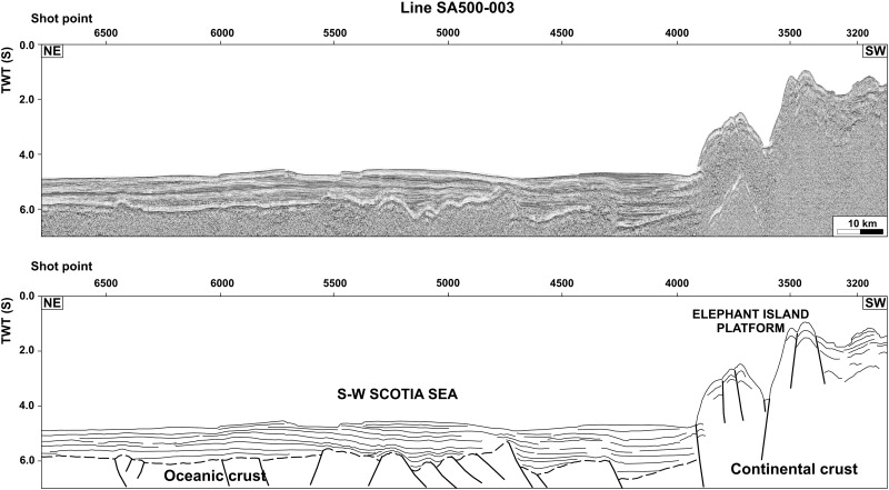
Seismic profile SA500-003 (top), and simplified line-drawing (bottom). Location in Fig. 3 |
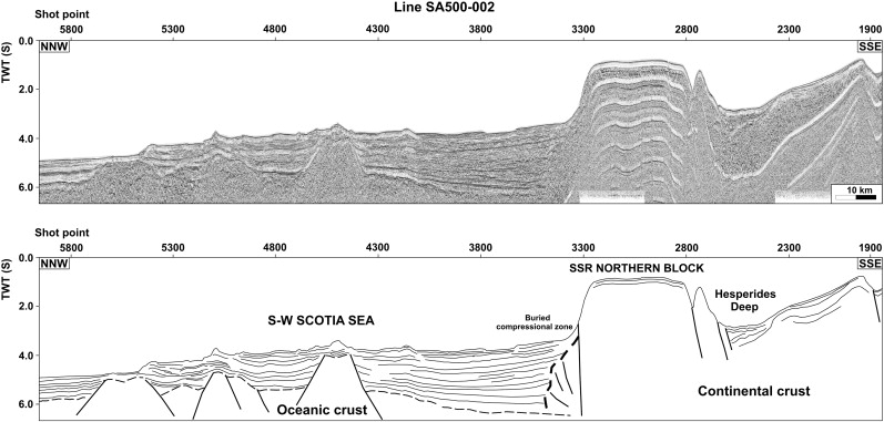
Seismic profile SA500-002 (top), and simplified line-drawing (bottom). Location in Fig. 3. |
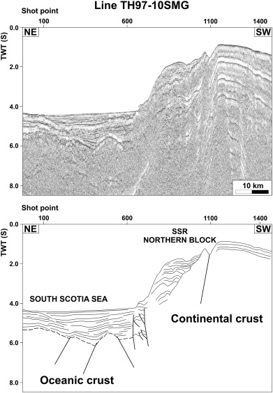
Seismic profile TH97-10SMG (top), and simplified line-drawing (bottom). Location in Fig. 3. |
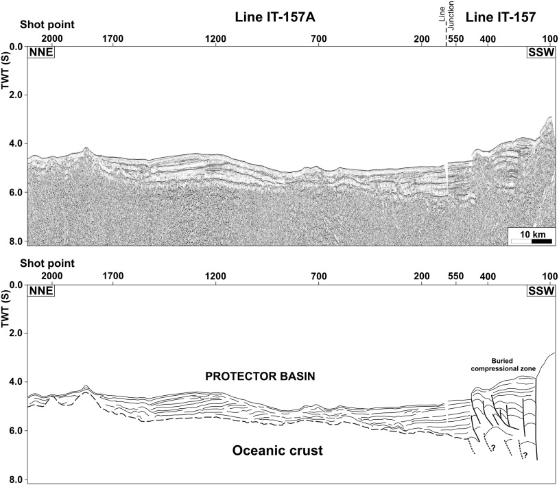
Seismic profiles IT-157 and IT-157A (top), and simplified line-drawing (bottom). Location in Fig. 3 |
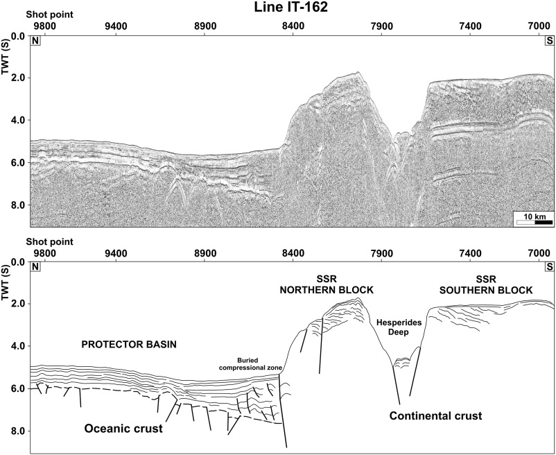
Seismic profile IT-162 (top), and simplified line-drawing (bottom). Location in Fig. 3. |
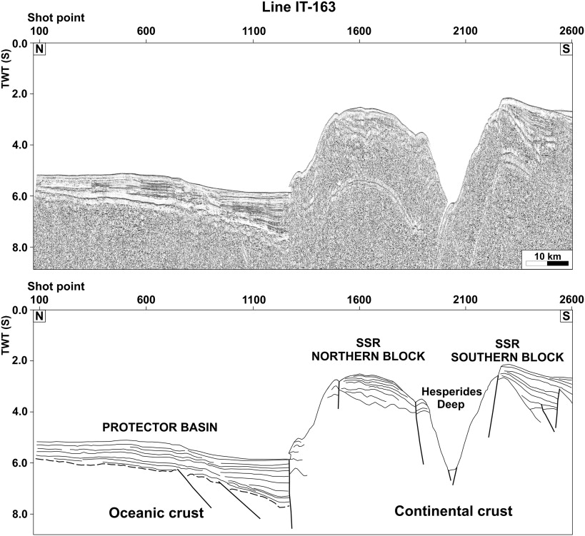
Seismic profile IT-163 (top), and simplified line-drawing (bottom). Location in Fig. 3. |
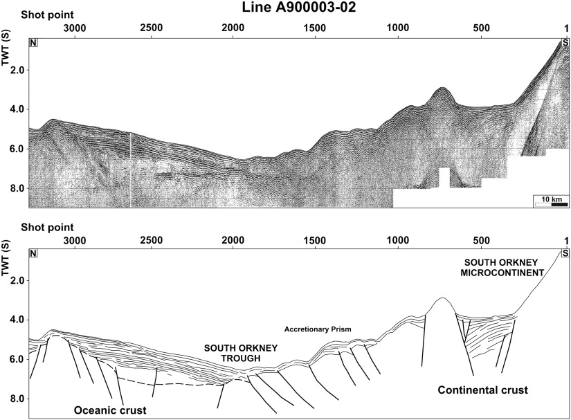
Seismic profile A900003-02 (top), and simplified line-drawing (bottom). Location in Fig. |
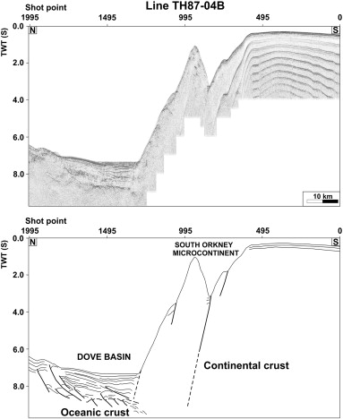
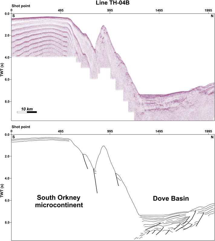
Seismic profile TH87-04B (top), and simplified line-drawing (bottom). Location in Fig. |
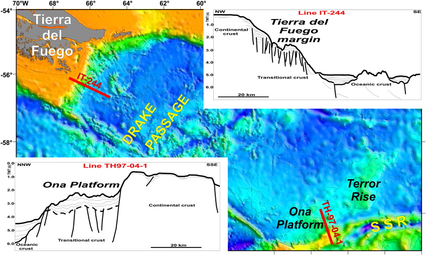
Satellite-derived bathymetric map (Smith and Sandwell, 1997) of the Drake Passage between Tierra del Fuego and the northern tip of the Antarctic Peninsula. Red segments refer to two representative seismic profiles (here presented as simplified line-drawings) crossing the conjugate margins of Tierra del Fuego (line IT-244, taken from Lodolo et al., 2006) and the Ona Platform (line TH97-04-1). SSR, South Scotia Ridge. |
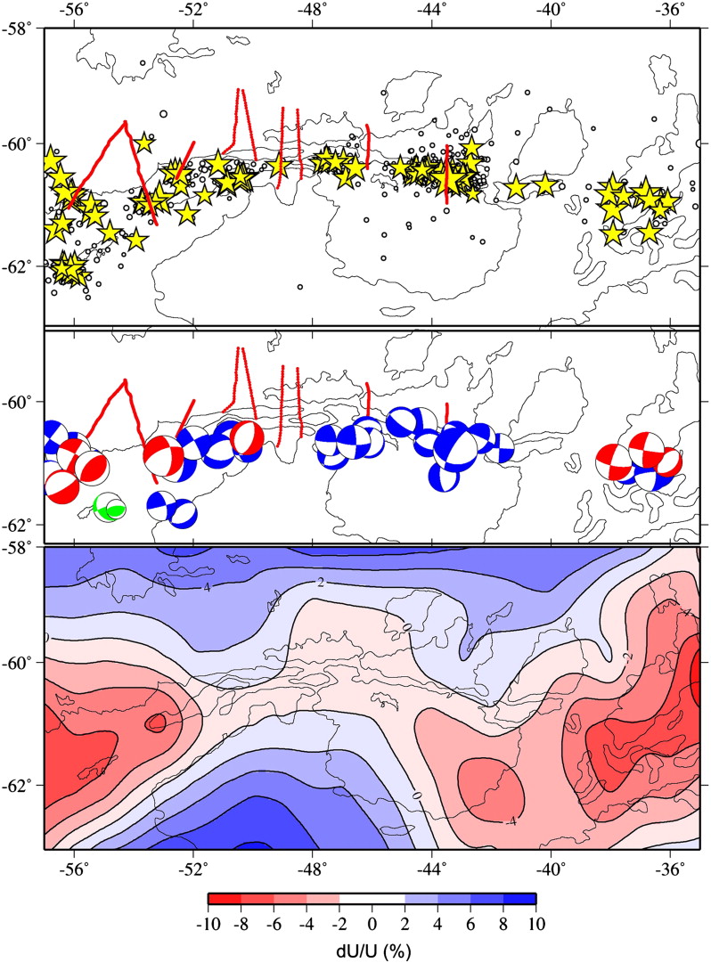
(top panel) Seismicity along the South Scotia Ridge from EHB (yellow stars) and ISC (circles) catalogs; (middle panel) focal mechanisms from Harvard CMT (blue), Guidarelli and Panza (2006) (green) and Pelayo and Wiens (1989) (red); (bottom panel) 40 s group velocity tomography at the ScotiaиCAntarctic plate boundary from Vuan et al. (2000). Group velocity U is presented as a percentage deviation from the average velocity. Blues indicate faster than group velocities average, and reds slower than group velocities average. Contour of 2000 m water depth is shown in the background. |
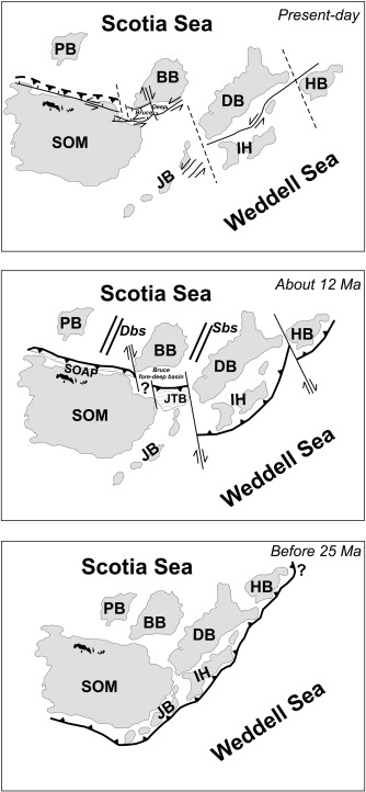
Simplified sketches of a possible tectonic evolution of the ScotiaЦAntarctica plate boundary between the northern Antarctic Peninsula and Herdman Bank. TdF, Tierra del Fuego; OP, Ona Platform; TR, Terror Rise; SOM, South Orkney microcontinent; PB, Pirie Bank; BB, Bruce Bank; JB, Jane Bank; DB, Discovery Bank; IH, Irizar Highs; HB, Herdman Bank; JTB, Jane Thrust Belt; PrB, Protector Basin; DvB, Dove Basin; ScB, Scan Basin; PwB, Powell Basin; JnB, Jane Basin; SOAP, South Orkney accretionary prism; EITZ, Elephant Island transpressional zone; EI, Elephant Island; AP, Antarctic Peninsula; SSI, South Shetland Islands; SFZ, Shackleton Fracture Zone; BrB, Bransfield Basin; HD, Hesperides Deep; SSBsb, South Shetland block southern boundary. |
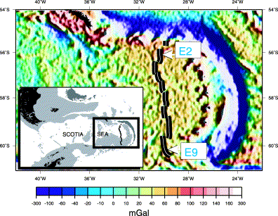
Satellite gravity map showing the location of segments E1ззCE9 of the ESR in the east Scotia Sea. Inset: location of the east Scotia Sea in the Atlantic sector of the Southern Ocean, due east of the Drake Passage which separates the Antarctic Peninsula from southernmost South America -http://www.sciencedirect.com/science/article/pii/S0012821X00003198 |
We have identified first evidence for the presence of submarine hydrothermal activity along the East Scotia Ridge an isolated back-arc spreading centre located at 55ззC60Ўз╘S in the Atlantic sector of the Southern Ocean. Using a combination of in situ optical light-scattering sensor data, and total dissolvable Mn concentrations, we demonstrate the existence of hydrothermal plumes overlying two segments of this ∼500 km ridge-crest; both segments exhibit anomalous topography and at least one segment is also underlain by an axial magma chamber seismic reflector. Future investigation of the fauna that inhabit these remote hydrothermal environments may provide an important Ў®missing linkЎЇ between the distinct biogeographical provinces delimited from previous investigation of northern Atlantic versus eastern Pacific vent-sites. Map of the Earth, projected from the Southern Hemisphere and centred on the ESR, showing the nearest known hydrothermal fields in the Pacific, Atlantic and Indian Oceans together with the recently discovered Bransfield Strait hydrothermal site , and . White+symbols designate latitudes 0Ўз╘, 30Ўз╘, 60Ўз╘ and 90Ўз╘S. Red circles in the Pacific and North Atlantic Oceans denote active vent-sites already visited by submersible whereas the Indian Ocean sites represent areas where hydrothermal plumes have been detected but active vent-sites remain to be investigated.http://www.sciencedirect.com/science/article/pii/S0012821X00003198 |
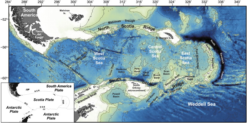
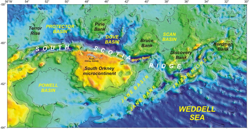
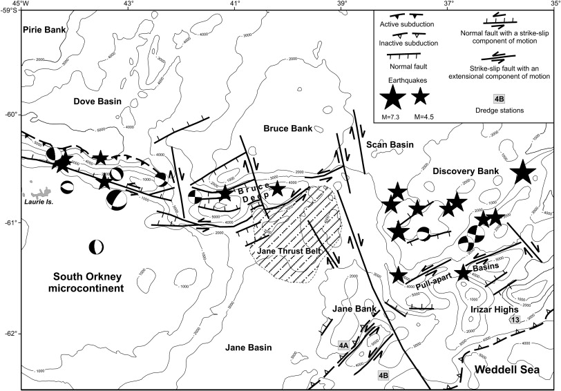
Bathymetric contour map of the Scotia Sea (based on satellite-derived data of Smith and Sandwell, 1997). Inset shows present-day plate tectonic setting. Abbreviations are as follows: NSR, North Scotia Ridge; SSR, South Scotia Ridge; ESR, East Scotia Ridge; SOI, South Orkney Islands; SFZ, Shackleton Fracture Zone. A compilation of available multichannel seismic profiles acquired along the southern margin of the Scotia Sea east of the South Orkney microcontinent has allowed identifying and mapping the main morphological and structural features of the central segment of the ScotiaЦAntarctica plate boundary. This margin is composed by several bathymetric highs of variable size and uncertain crustal nature, separated by deep troughs and restricted oceanic basins. Some of these troughs represent pull-apart basins. Three main segments oriented WNWЦESE (the western sector), ENEЦWSW (the central sector, here named Bruce Deep), and NEЦSW (the eastern sector), have been described. These segments are separated by NNWЦSSE-trending release zones, disposed in an en-echelon geometry, which represent mostly strikeЦslip faults. The western segment corresponds to the northern margin of the South Orkney microcontinent, where a subduction zone seems to be present, even if its present-day activity is unclear. The segment further to the east corresponds to an ENE-oriented basin (Bruce Deep), which separates the Bruce Bank from the eastern promontory of the South Orkney continental platform. To the south of the Bruce Deep, a wide deformation zone with N-verging folds and thrusts (here named Jane Thrust Belt), has been identified from seismic data. The eastern segment of the plate boundary is structurally the less constrained, and may be composed by a series of tectonic lineaments of different lengths. From the Bruce Bank to the east, focal mechanisms maintain a prevalent left-lateral strikeЦslip motion combined with an extensional component. In this sector, earthquakes are located in a 150 km wide area and on a local scale are difficult to follow unambiguously at the plate boundary. Lithologic analyses on dredged material recovered along a flank of one of the morphological relieves present south of the Discovery Bank to 35░W (here collectively named Irizar Highs), yielded a dominant granitic composition. A similar composition characterizes the rocks collected in the southern flank of the south-easternmost Jane Bank. This suggests a continental crust nature for these bathymetric highs, now dispersed along this sector of the ScotiaЦAntarctica plate boundary. We propose here a tectonic evolution for this margin, dominated since the Early Miocene by the northward subduction of the Weddell Sea oceanic crust. The development of a dextral, en-echelon transform fault system facilitated the process of fragmentation and dispersion of the crustal blocks, dismembered the subduction zone, and possibly inverted the direction of convergence: Therefore, the Scotia plate would subduct beneath the Antarctic plate, in the western sector, and Weddell Sea would subduct beneath Scotia plate, in the eastern sector. Finally, the activation of left-lateral transtensional strikeЦslip lineaments generated narrow pull-apart basins in the fore-arc sectors of the convergent zones -http://www.sciencedirect.com/science/article/pii/S0012821X10000087 |
General physiographic map of the southern margin of the Scotia Sea, with the principal geological provinces discussed in the text. Bathymetric contours from satellite-derived data. Abbreviations are as follows: CI, Coronation Island; LI, Laurie Island (Smith and Sandwell, 1997).General physiographic map of the southern margin of the Scotia Sea, with the principal geological provinces discussed in the text. Bathymetric contours from satellite-derived data. Abbreviations are as follows: CI, Coronation Island; LI, Laurie Island (Smith and Sandwell, 1997). |
Seismic lines location map. Thick segments indicate the corresponding figures presented. Bathymetric contours every 1000 m. |
Structural map and earthquake data of the ScotiaЦAntarctica plate boundary along the south Scotia Sea margin. Seismic foci (1961Ц2006) are taken from Engdahl et al. (1998). Focal mechanisms from the Global Centroid Moment Tensor database, formerly known as the Harvard CMT catalog http://www.globalcmt.org/CMTsearch.html. Dredge locations are also shown |
Multichannel seismic profile TH-04B (top) and interpreted line drawing (bottom). |
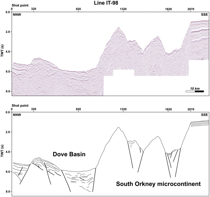
Multichannel seismic profile IT-98 (top) and interpreted line drawing (bottom). |
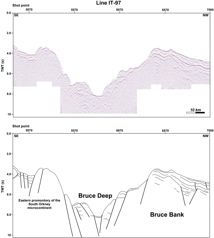
Multichannel seismic profile IT-97 (top) and interpreted line drawing (bottom). |
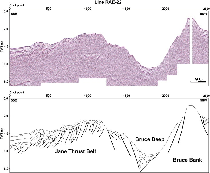
Multichannel seismic profile RAE-22 (top) and interpreted line drawing (bottom). |
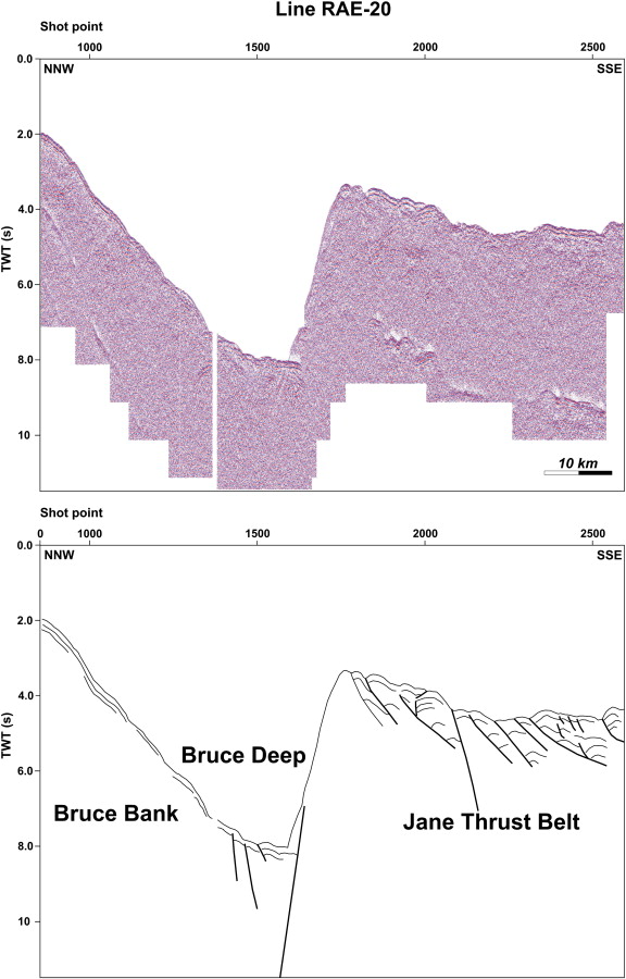
Multichannel seismic profile RAE-20 (top) and interpreted line drawing (bottom). |
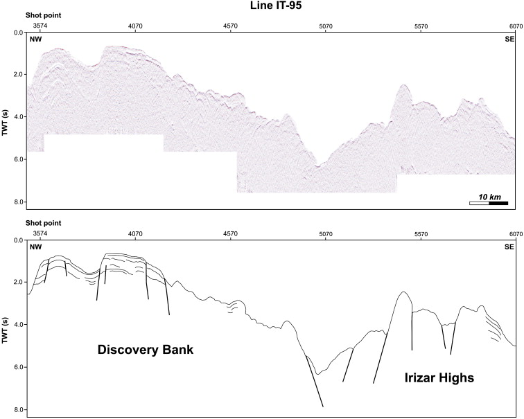
Multichannel seismic profiles IT-95 (top) and interpreted line drawing (bottom). |
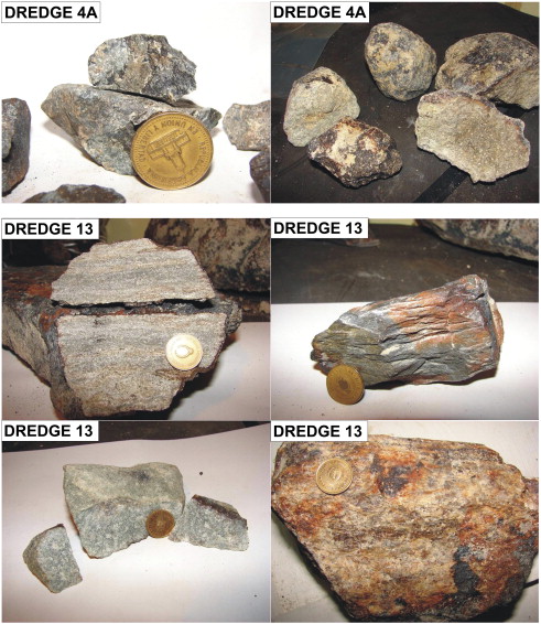
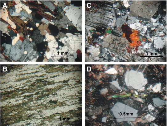
Two examples of rocks recovered at site 4A (see dredge location in Fig. 4). (left): metamorphic rocks (gneiss) with quartz veins; (right): plutonic samples (granitoids) mainly composed by grey feldspars. (bottom) Some examples of rocks (schists and metaquartzites) recovered at site 13 (see dredge location in Fig. 4). |
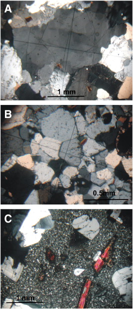
(A, B, C). Photomicrographs of some representative samples recovered by dredge 4A XPL light. See text for lithologic characteristic of each sample |
Three simplified sketches of a possible tectonic evolution of the ScotiaЦAntarctica plate boundary between the South Orkney microcontinent and the Herdman Bank. Abbreviations are as follows: SOM, South Orkney microcontinent; PB, Pirie Bank; BB, Bruce Bank; JB, Jane Bank; DB, Discovery Bank; IH, Irizar Highs; HB, Herdman Bank; SOAP, South Orkney accretionary prism; JTB, Jane Thrust Belt; DBs, Dove Basin; SBs, Scan Basin. |
(A, B, C, D). Photomicrographs of some representative samples recovered by dredge 13; XPL light for A, C, D, PL light for B. See text for lithologic characteristic of each sample.http://www.sciencedirect.com/science/article/pii/S0012821X10000087 |
Despite a spreading rate of 65иC70 km Ma−1, the East Scotia Ridge has, along most of its length, a form typically associated with slower rates of sea floor spreading. This may be a consequence of cooler than normal mantle upwelling, which could be a feature of back-arc spreading. At the northern end of the ridge, recently acquired sonar data show a complex, rapidly evolving pattern of extension within 100 km of the South Sandwich Trench. New ridge segments appear to be nucleating at or near the boundary between the South American and Scotia Sea plates and propagating southwards, supplanting older segments. The most prominent of these, north of 56бу30бфS, has been propagating at a rate of approximately 60 km Ma−1 for at least 1 Ma, and displays a morphology unique on this plate boundary. A 40 km long axial high exists at the centre of this segment, forming one of the shallowest sections of the East Scotia Ridge. Beneath it, seismic reflection profiles reveal an axial magma chamber, or AMC, reflector, similar to those observed beneath the East Pacific Rise and Valu Fa Ridge. Simple calculations indicate the existence here of a narrow (<1 km wide) body of melt at a depth of approximately 3 km beneath the sea floor. From the topographic and seismic data, we deduce that a localised mantle melting anomaly lies beneath this segment. Rates of spreading in the east Scotia Sea show little variation along axis. Hence, the changes in melt supply are related to the unique tectonic setting, in which the South American plate is tearing to the east, perhaps allowing mantle flow around the end of the subducting slab. Volatiles released from the torn plate edge and entrained in the flow are a potential cause of the anomalous melting observed. A southward mantle flow may have existed beneath the axis of the East Scotia Ridge throughout its history -http://www.sciencedirect.com/science/article/pii/S0012821X97000745 |

From http://www.sciencedirect.com/science/article/pii/S0040195112005008
The Scotia Sea in the South Atlantic holds a prominent position in geodynamics, because it has been proposed as a potential outlet of asthenosphere from under the shrinking Pacific into the mantle beneath the opening Atlantic. Shear wave splitting and geochemical studies have previously tested this hypothesis. Here, we take a different approach by calculating present-day dynamic topography of the region in search for a systematic trend in dynamic topography decreasing from west to east in response to a flow-related pressure gradient in the sublithospheric mantle. To this end, we reconstruct the kinematic history of the Scotia Sea, which is characterized by complex back-arc spreading processes active on a range of time scales. Our plate reconstructions allow us to derive an oceanic age-grid and to calculate the associated residual (dynamically maintained) topography of the Scotia Sea by comparing present-day isostatically corrected topography with that predicted from our reconstruction. The results provide no indication for a systematic trend in dynamic topography and we conclude that the material needed to supply the growing subatlantic mantle must be derived from elsewhere
from Hypothesis of the formation of the Scotia and Caribbean seas
On the basis of available data it can be shown that the hypothesis of an expanding earth cannot solve space problems arising from sea-floor spreading and continental drift. It is suggested that the Caribbean and Scotia Arcs were considerably less curved when, in the movement of the continents away from the center of a pre-drift supercontinent, the perimeter of the Pacific advanced from one hemisphere to the other. Thereafter the Caribbean and Scotia Seas were formed as portions of Pacific crust were pinched out between the westward advancing and mutually approaching continents of North America and South America and South America and Antarctica respectively. All available evidence indicates that in spite of the presence of spreading ridges in the Pacific, this ocean as a whole must still be decreasing in size.
Satellite-fixed magnetic and bathymetric data confirm the presence of a spreading centre in the east Scotia Sea behind the South Sandwich island arc and trench. Spreading is slightly asymmetric, favouring the eastern, island arc side, and the total spreading rate has increased from 5 to 6 cm/yr 4 Ma ago, to 7 to 9 cm/yr at present. The close similarity between this feature and the signs of secondary extension found in the marginal basins of the Western Pacific suggests that the usual Vine-Matthews anomalies may be found there also. A spreading centre in the east Scotia sea
http://www.sciencedirect.com/science/article/pii/0012821X72900520
Tectonics of the ScotiaбьбьCAntarctica plate boundary constrained from seismic and seismological data
The plate boundary between the Scotia and Antarctic plates runs along the broadly EбьбьCW trending South Scotia Ridge. It is a mainly transcurrent margin that juxtaposes thinned continental and transitional crust elements with restricted oceanic basins and deep troughs. Seismic profiles and regional-scale seismological constraints are used to define the peculiarities of the crustal structures in and around the southern Scotia Sea, and focal solutions from recent earthquakes help to understand the present-day geodynamic setting. The northern edge of the western South Scotia Ridge is marked by a sub-vertical, left-lateral master fault. Locally, a narrow wedge of accreted sediments is present at the base of the slope. This segment represents the boundary between the Scotia plate and the independent South Shetland continental block. Along the northern margin of the South Orkney microcontinent, the largest fragment of the South Scotia Ridge, an accretionary prism is present at the base of the slope, which was possibly created by the eastward drift of the South Orkney microcontinent and the consequent subduction of the transitional crust present to the north. East of the South Orkney microcontinent, the physiography and structure of the plate boundary are less constrained. Here the tectonic regime exhibits mainly strikeбьбьCslip behavior with some grade of extensional component, and the plate boundary is segmented by a series of NNWбьбьCSSE trending release zones which favored the fragmentation and dispersion of the crustal blocks. Seismic data have also identified, along the north-western edge of the South Scotia Ridge, an elevated region бьбьC the Ona Platform бьбьC which can be considered, along with the Terror Rise, as the conjugate margin of the Tierra del Fuego, before the Drake Passage opening. We propose here an evolutionary sketch for the plate boundary (from the Late Oligocene to the present) encompassing the segment from the Elephant Island platform to the Herdman Bank -http://www.sciencedirect.com/science/article/pii/S0040195112002545
A new model for the evolution of the Scotia Arc is presented. During the Late Jurassic-Early Cretaceous, contemporaneous with the initial separation of eastern and western Gondwanaland, a volcanic arc founded on continental crust broke away from the ЎЎз╘south-westernЎЎзб margin of the supercontinent, allowing the intrusion of mafic magma directly behind the active arc (back-arc spreading). This led to the development of the mafic crust of an ensialic marginal basin. This basin extended from southern South America where ophiolites representing the relics of the uplifted floor of the basin have been recognized along the Andean Cordillera as far north as 51Ўбьз╢S, through the central part of the Scotia Sea, which is shown to have a geophysical characteristics comparable to some of the western Pacific marginal basins, and probably southward into the Weddel Sea. The Falkland (Malvinas) Trough may represent the first manifestation of the back-arc extension. The Antarctic Peninsula, the southernmost, bathymetrically elevated, portion of the central Scotia Sea, and the Patagonian batholith along the Pacific margin of South America, represent the frontal volcanic arc.
The eastern and western parts of the Scotia Sea floor were generated during the Cenozoic as South America and Antarctic separated from Africa and by differential motion of the South American and Antarctic plates.
The model, together with new geologic data, leads to a new reconstruction of south-western Gondwanaland http://www.sciencedirect.com/science/article/pii/0040195177900397
A new model for the evolution of the Scotia Arc is presented. During the Late Jurassic-Early Cretaceous, contemporaneous with the initial separation of eastern and western Gondwanaland, a volcanic arc founded on continental crust broke away from the ЎЎз╘south-westernЎЎзб margin of the supercontinent, allowing the intrusion of mafic magma directly behind the active arc (back-arc spreading). This led to the development of the mafic crust of an ensialic marginal basin. This basin extended from southern South America where ophiolites representing the relics of the uplifted floor of the basin have been recognized along the Andean Cordillera as far north as 51Ўбьз╢S, through the central part of the Scotia Sea, which is shown to have a geophysical characteristics comparable to some of the western Pacific marginal basins, and probably southward into the Weddel Sea. The Falkland (Malvinas) Trough may represent the first manifestation of the back-arc extension. The Antarctic Peninsula, the southernmost, bathymetrically elevated, portion of the central Scotia Sea, and the Patagonian batholith along the Pacific margin of South America, represent the frontal volcanic arc.
The eastern and western parts of the Scotia Sea floor were generated during the Cenozoic as South America and Antarctic separated from Africa and by differential motion of the South American and Antarctic plates.
The model, together with new geologic data, leads to a new reconstruction of south-western Gondwanaland in which the Paleozoic/Early Mesozoic rocks of southern South America and the Antarctic Peninsula represent the arcЎЄtrench tectonic environment of the ЎЎз╘Samfrau geosynclineЎЎзб. http://www.sciencedirect.com/science/article/pii/0040195177900397
The volatile content of glassy pillow rims from East Scotia Sea back-arc basin (BAB) lavas are unlike those of mid-ocean ridge (MOR) pillow-rim glasses, although non-volatile compositions of the two rock groups overlap. The East Scotia Sea samples have three to ten times greater water contents and nearly twice the average CO2 and Cl contents of MOR samples; F contents are similar. S contents are only one-third those from MOR samples. H2O and CO2 contents of glassy pillow rims from Mariana island arc andesites are similar to those in the BAB lavas studied. Nevertheless, volatiles in the East Scotia Sea BAB magmas are probably not directly derived from the subducted slab, because there is no seismic evidence that the slab extends within 200 km of the spreading axis of the East Scotia Sea. Available data do not preclude the possibility that the magmas were contaminated by seawater prior to eruption or that the mantle under the East Scotia Sea spreading center is volatile-rich. The volatiles may have been added to the mantle during an earlier period of subduction, perhaps during the initial formation of the East Scotia Sea basin http://www.sciencedirect.com/science/article/pii/0012821X80900436
Despite a spreading rate of 65бьбьC70 km Ma−1, the East Scotia Ridge has, along most of its length, a form typically associated with slower rates of sea floor spreading. This may be a consequence of cooler than normal mantle upwelling, which could be a feature of back-arc spreading. At the northern end of the ridge, recently acquired sonar data show a complex, rapidly evolving pattern of extension within 100 km of the South Sandwich Trench. New ridge segments appear to be nucleating at or near the boundary between the South American and Scotia Sea plates and propagating southwards, supplanting older segments. The most prominent of these, north of 56Ўбьз╢30Ўбьз╖S, has been propagating at a rate of approximately 60 km Ma−1 for at least 1 Ma, and displays a morphology unique on this plate boundary. A 40 km long axial high exists at the centre of this segment, forming one of the shallowest sections of the East Scotia Ridge. Beneath it, seismic reflection profiles reveal an axial magma chamber, or AMC, reflector, similar to those observed beneath the East Pacific Rise and Valu Fa Ridge. Simple calculations indicate the existence here of a narrow (<1 km wide) body of melt at a depth of approximately 3 km beneath the sea floor. From the topographic and seismic data, we deduce that a localised mantle melting anomaly lies beneath this segment. Rates of spreading in the east Scotia Sea show little variation along axis. Hence, the changes in melt supply are related to the unique tectonic setting, in which the South American plate is tearing to the east, perhaps allowing mantle flow around the end of the subducting slab. Volatiles released from the torn plate edge and entrained in the flow are a potential cause of the anomalous melting observed. A southward mantle flow may have existed beneath the axis of the East Scotia Ridge throughout its history.http://www.sciencedirect.com/science/article/pii/S0012821X97000745
The Scotia Sea gateway: No outlet for Pacific mantle
Hydrothermal plumes above the East Scotia Ridge: an isolated high-latitude back-arc spreading centre
next