 | Scotia |
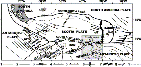
Geological setting of the study area in the frame of the Scotia Arc. Modified from Galindo-Zaldı́var et al. [8]. 1, Inactive fracture zone; 2, active fracture zone; 3, transform or transcurrent fault; 4, inactive subduction or reverse fault; 5, active subduction; 6, extensional fault; 7, active spreading axis; 8, inactive spreading axis; 9, continental-oceanic crustal boundary. FZ, fracture zone; APR, Antarctic-Phoenix Ridge; WSR, West Scotia Ridge; PB, Powell Basin; SOM, South Orkney Microcontinent; JB, Jane Basin; DB, Discovery Bank; HB, Herdman Bank.Active crustal fragmentation along the ScotiaЁCAntarctic plate boundary east of the South Orkney Microcontinent (Antarctica). The structure of the ScotiaЁCAntarctic plate boundary is poorly known east of the South Orkney Microcontinent. New multichannel seismic profiles, together with magnetic, gravity and swath bathymetry data obtained during the SCAN97 cruise, show a complex relief of raised blocks and elongated depressions that may reach more than 6000 m in depth. These depressions develop in relation with extensional active structures and constitute an uncommon feature in the oceans, where most of the trenches are formed in subduction contexts. The main crustal elements of the area include the oceanic crust of the Scotia Plate, the Discovery Bank composed of continental crust, a tectonic domain with intermediate features between continental and oceanic crusts that includes the Southern Bank, and the oceanic crust of the northern Weddell Sea, representing the Antarctic Plate. The Intermediate Domain was probably developed during the Late Cenozoic subduction of the Weddell Sea oceanic crust below the Discovery Bank. The fault zone associated with the plate boundary is characterized at present by sinistral transcurrent and transtensional slips, which develop a NEЁCSW elongated deep pull-apart basin with extreme crustal thinning and mantle uplift. The complex bathymetry and structure of the plate boundary are consequences of the presence of continental and intermediate crusts ЁC where the deformations are concentrated ЁC between the two stable oceanic domains. The location of a major part of the plate boundaries around the Scotia Arc is probably determined by the position of the continental and intermediate crustal fragments surrounded by oceanic crust, due to the differential behavior experienced during deformation.http://www.sciencedirect.com/science/article/pii/S0012821X02009597 |
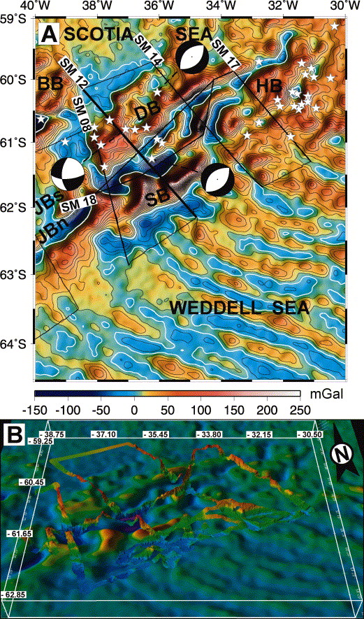
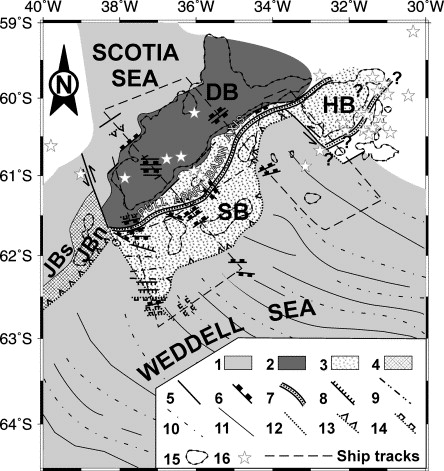
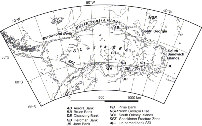
GEOSAT free-air gravity anomaly map [20] including location chart of the SCAN 97 cruise with B/O Hespйrides track lines (A) and multibeam bathymetry plotted over satellite predicted bathymetry (B). A: Contour lines at 10 mGal intervals. Stars: earthquake epicenters (1973ЁC2002) [17]. Earthquake focal mechanisms from Pelayo and Wiens [2]. Thick line, SM12 MCS profile on Fig. 3. BB, Bruce Bank; JBs, Jane Basin; JBn, Jane Bank; SB, Southern Bank; DB, Discovery Bank; HB, Herdman Bank. B: Deep areas, blue; shallow areas, red. |
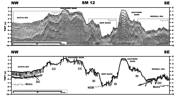
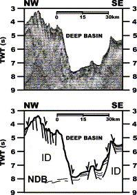
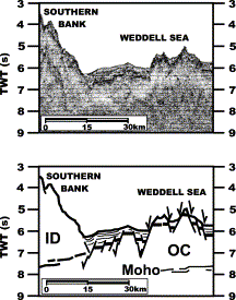
SM12 multichannel seismic profile and interpretation. Location in Fig. 2. OC, oceanic crust; CC, continental crust; ID, Intermediate Domain; NDB, northward dipping band of reflectors. The positions of blow-ups in Fig. 4, Fig. 5 and Fig. 6 are indicated |
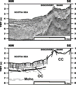
Enlarged view of SM12 multichannel seismic profile showing the northern border of Discovery Bank and the Scotia Sea. Location in Fig. 3. OC, oceanic crust; CC, continental crust |
Enlarged view of SM12 multichannel seismic profile showing the Deep Basin in the Intermediate Domain (ID). Location in Fig. 3. |
Enlarged view of SM12 multichannel seismic profile showing the Southern Bank and Weddell Sea. Location in Fig. 3. OC, oceanic crust; ID, Intermediate Domain |
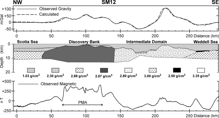
Free-air gravity profile and model, and total field magnetic anomaly profile. PMA, anomaly resembling the Pacific Margin Anomaly. See text for discussion. Location in Fig. 2. |
Geological sketch of the main tectonic structures. 1, Oceanic crust; 2, continental crust; 3, intermediate crust; 4, volcanic arc; 5, active fault; 6, active normal fault; 7, active maximum crustal thinning axis, the stretched region covers a broad band; 8, scarp; 9, ridge; 10, elongated gravity minima; 11, elongated gravity maxima; 12, inactive fracture zone; 13, inactive subduction or reverse fault; 14, inactive normal fault; 15, 2000 m depth bathymetry contour line; 16, earthquake epicenters (1973ЁC2002) [17]. JBs, Jane Basin; JBn, Jane Bank; DB, Discovery Bank; HB, Herdman Bank; SB, Southern Bank. |
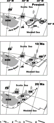
Paleogeographic reconstruction of main tectonic elements. Based in previous reconstructions of the Scotia Arc and and modified with own data. 1, Transform fault; 2, subduction zone; 3, oceanic spreading axis; 4, active maximum crustal thinning axis. BB, Bruce Bank; DB, Discovery Bank; HB, Herdman Bank; JB, Jane Bank; PB, Pirie Bank; SB, Southern Bank; SOM, South Orkney Microcontinent.http://www.sciencedirect.com/science/article/pii/S0012821X02009597 |
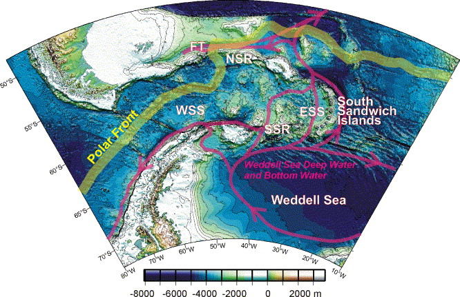
Drake Passage bathymetry [1] with present-day currents. The Polar front is an averaged path from sea surface temperature data after [2]. Weddell Sea deep water flows are schematic, after [3]. ESS, East Scotia Sea; FT, Falkland Trough; NSR, North Scotia Ridge; SSR, South Scotia Ridge; WSS, west Scotia Sea.Small basins in the Scotia Sea: The Eocene Drake Passage gateway.After isostatic correction for their sedimentary fill, the depths of two small oceanic basins in the southern Scotia Sea suggest that both started to open in mid to late Eocene times. Models of the short magnetic anomaly profiles across the basins provide support for these determinations. The location of the basins, adjacent to the present-day Drake Passage marine gateway, and the timing of continental stretching leading up to their opening, during the Ypresian (early Eocene) onset of global cooling, mean that their importance is potentially far greater than their small size implies. Extension in the region of the two basins would have opened Drake Passage to shallow or intermediate depth oceanic circulation between the Pacific and Atlantic oceans for the first time. This coincided with a reorganisation of vertical mixing patterns in the global ocean, a shift in the site of carbon sequestration from coal swamps and peatlands to ocean sediments, and the onset of a long decline in atmospheric carbon dioxide concentrations. Cenozoic global cooling may therefore have begun as a result of the shallow opening of Drake Passage -http://www.sciencedirect.com/science/article/pii/S0012821X05008411 |
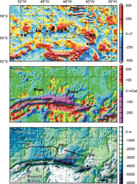
The southern parts of the Scotia Sea, as shown by magnetic (top; grid from a compilation of marine track line data [5]), free-air gravity (middle; [8]), and bathymetric (bottom; [1]) data. Bruce Bank core location is shown by a black disc. Abbreviations as in Fig. 1 and also BB: Bruce Bank; DB, Discovery Bank; PB Pirie Bank; Prot, Protector Basin; TR, Terror Rise. Magnetic anomaly profiles from Fig. 5 and Fig. 7 are shown in the top panel. The seismic reflection profiles from Fig. 4 and Fig. 6 are located by bold lines in the bottom panel. |
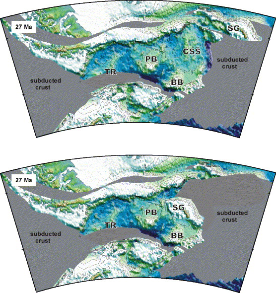
27 Ma/anomaly C8 reconstructions. Top: assuming an Ў«oldЎЇ central Scotia Sea. Bottom: reconstruction with a post-C8 central Scotia Sea closed. The North Scotia Ridge would have been deeper than shown, due to post-17 Ma uplift [5] and the seafloor of the small basins, west Scotia Sea, and northern Weddell Sea would have been slightly shallower than shown, due to post-C8 thermal subsidence. Colour scale as in Fig. 1. Abbreviations as in Fig. 1 and Fig. 2, and also SG: South Georgia. |
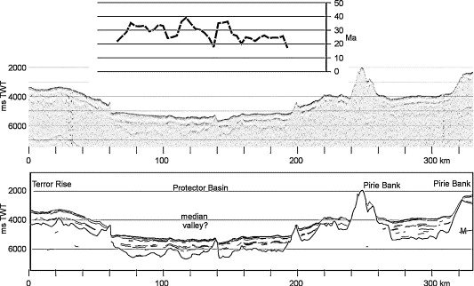
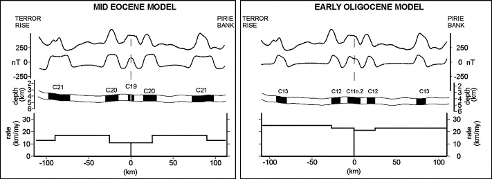
Protector basin: single channel seismic data (acquired by the British Antarctic Survey in 1975). The top panel shows model ages determined from the depth of the basin floor in those parts where linear magnetic anomalies, formed in seafloor spreading, occur, after an isostatic correction for the imaged sediment layer is applied to the bathymetry. M: multiple. |
Two models of the magnetic anomalies in Protector Basin. The data profile (solid line, cruise End690; see Fig. 2 for location) is projected onto 90Ўг and the model profiles (dashed line) are made using the present-day bathymetry as the top surface of a 1 km thick source model with effective susceptibility of 0.005 |
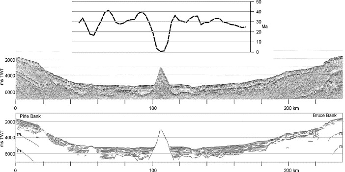
Dove basin: seismic data for age-depth determination (acquired by the British Antarctic Survey in 1989). The top panel shows model ages determined from the depth of the basin floor in those parts where linear magnetic anomalies, formed in seafloor spreading, occur, after an isostatic correction for the imaged sediment layer is applied to the bathymetry. m: multiple. |
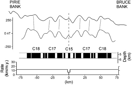
Model of the magnetic anomalies in Dove Basin. The data profile (solid line, cruise D172; see Fig. 2 for location) is projected onto 115Ўг and the model profile (dashed line) is made using a flat 4.75 km deep layer as the top surface of a 1 km thick source model with effective susceptibility of 0.005 |
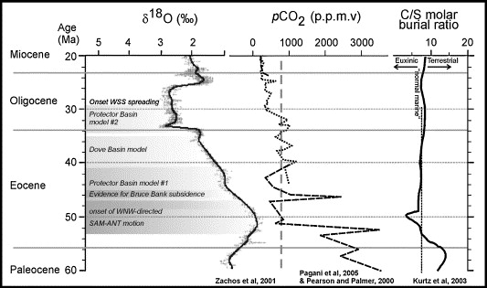
Scotia Sea extensional events plotted alongside a benthic д18O curve (heavier values indicate increased ice volume and decreased bottom water temperature, reprinted with permission from [7], copyright 2001, AAAS), atmospheric partial pressure of CO2 (pCO2: dotted line reprinted with permission from [37], copyright 2005, AAAS; dashed line [38]), and a curve showing the molar burial ratio for carbon and sulphur isotopes [42], which can be interpreted as indicating the dominant sites of organic matter burial. Vertical grey dashed line is the threshold value of pCO2 below which a model Antarctic glaciation occurred [35] -http://www.sciencedirect.com/science/article/pii/S0012821X05008411 |
Generalised map of the Scotia Sea region, to show the bathymetry, the island blocks and the principal sea-mounts comprising the Scotia arc. For clarity, only the 1000, 2000 and 3000 m submarine contours are shown.There is an extensive literature on the geological development of the Scotia Sea and the Scotia arc, and its relations to the development of the Antarctic Circum-polar Current (ACC) and potential implications for Antarctic glaciation. However, most of the relevant papers have been written from a tectonic or geophysical perspective, with no consideration of the biological implications of the momentous changes involved. This review is an attempt to summarise aspects of the geographical, oceanographical and climate changes that are likely to have had biological consequences for the marine faunas of the MagellanЁCAntarctic region. There remain many uncertainties over the timing of events and the paucity of information on the palaeogeographical history of the fragments of the Scotia arc. Thus, whilst there is a growing body of evidence to suggest that the first Antarctic ice sheets, the opening of Drake Passage and the development of the ACC occurred within just a few million years of each other, there is not yet enough precision to be sure of the possible interrelationships, if any. Furthermore, an exposed rock record that is very limited in both stratigraphical and geographical extent leaves many uncertainties concerning the distribution of fossil animals in space and time. Despite the difficulties and uncertainties, however, much can be done with the existing data by taking a truly multidisciplinary approach, firstly to reassess possible interrelationships between physical and biological knowledge of the area, and secondly to direct future research in the region. Geological and palaeoenvironmental history of the Scotia Sea region as a basis for biological interpretation http://www.sciencedirect.com/science/article/pii/S0967064504001407 |
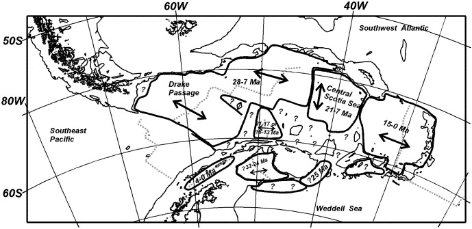
Map of the Scotia Sea region, simplified from Fig. 1, to show the main areas of oceanic crust, outlined in bold. Only the 2000 m bathymetric contour is shown. The double-ended arrows indicate spreading directions, with the period of spreading in millions of years (Ma). Bold question marks indicate areas of ocean floor for which there are no age data. (Seafloor data redrawn from Barker, 2001). |
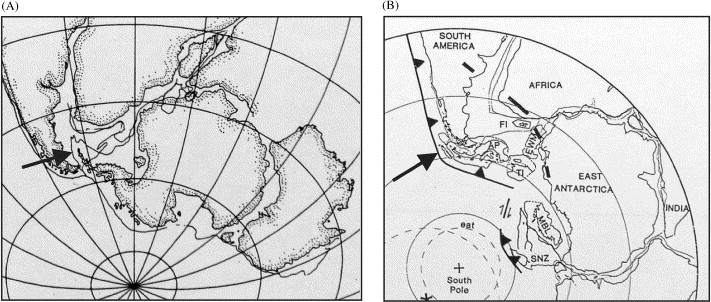
Palaeocontinental reconstructions to show differences resulting from the use of a fixed Antarctica (A), and a West Antarctica made of microplates (B). (A) Detail from a reconstruction by Norton and Sclater (1979, Fig. 19) for the Jurassic, with the Antarctic Peninsula (arrowed) overlapping onto the Falkland Plateau. Curiously, more recent theories suggest that the Falkland Islands may have lain to the east of southern Africa at the time and this reconstruction may not be quite as problematical as was once thought. (B) Detail from a reconstruction by Grunow et al. (1991, Fig. 5a) for 230 Ma, with West Antarctica as a series of microplates and the Antarctic Peninsula (AP, arrowed) lying alongside western southern South America. Note the Falkland Islands (FI) located off the eastern coast of southern Africa. Other abbreviations: EWW=Ellsworth-Whitmore mountains block, MBL=Marie Byrd Land, SNZ=South Island, New Zealand, TI=Thurston Island |
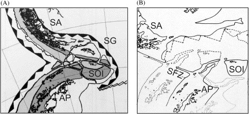
Origin of Drake Passage: (A) Reconstruction for 40 Ma ago of the junction between southern South America and the Antarctic Peninsula as a tightly assembled cusp (from Barker, 2001, Fig. 4). AP=Antarctic Peninsula, SA=South America, SG=South Georgia, SOI=South Orkney Islands; toothed lines indicate subduction zones. (B) Detail from Barker and Burrell (1982, Fig. 43.1) showing a schematic representation of Drake Passage opening from an original cuspate junction between South America (SA) and the Antarctic Peninsula (AP); dashed line=ca. 29 Ma ago, solid line=ca. 20 Ma ago, dotted line=present day. Note how the passage would have been blocked by the topographic high of the tectonic sliver along the Shackleton Fracture Zone (SFZ) until about 23.5 Ma ago |
Details from the reconstructions of the history of oceanic connections around Antarctica to show different postulated movement histories for South Georgia. (A) and (B) are from Lawver et al. (1992, Figs. 14 and 15, respectively) and show South Georgia (SG) moving eastwards from an original position close to the south-eastern tip of South America, along the southern margin of the Falkland Plateau. (A) 30 Ma, Early Oligocene; (B) 20 Ma, Early Miocene; (C) is from a later series of reconstructions by Lawver and Gahagan (2003, Fig. 6) and shows South Georgia at 30 Ma in a southerly location, close to the South Orkney microcontinent. Compare with Fig. 1 and Fig. 2 for the present location of South Georgia |
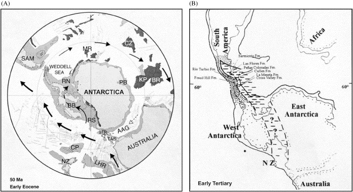
Representations of a possible Trans-Antarctic seaway: (A) Palaeocontinental reconstruction for the early Eocene, from Lawver and Gahagan (2003, Fig. 3), showing a possible current from the Ross Sea (RS), through the Bentley subglacial TroughЁCByrd subglacial Basin (BB) into the Ronne embayment (RN) of the Weddell Sea region. (B) Palaeogeographical reconstruction, showing a land connection between southern South America and western Antarctica, and early Cenozoic (Paleocene and Eocene) fossil-bearing formations. Note the depiction of a possible marine connection extending from New Zealand (NZ) to the South Atlantic region, between East and West Antarctica. From Reguero et al. (2002, Fig. 3); stippled ornament=land, dashed ornament=shallow sea.http://www.sciencedirect.com/science/article/pii/S0967064504001407 |
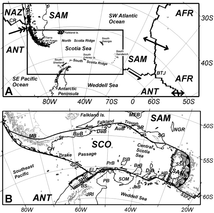
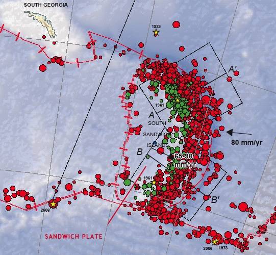
Major plate and microplate boundaries and motions. (A) Major plate boundaries and motions in the Southwest Atlantic and Southeast Pacific, showing vectors of plate motion (SAMЁCANT motion is 20 mm/a at the Chile Trench, other vectors are to scale and NazcaЁCSAM motion, north of the Chile triple junction, is much fasterЎЄ75ЁC80 mm/a). BTJ is the Bouvet triple junction and CR the Chile Rise. Inset (B) shows smaller plates in the Scotia Sea region (Scotia SCO, Sandwich SAN and Shetland SHE), with directions of motion at boundaries, epicentres of shallow earthquakes and locations of features described in the text: along the North Scotia Ridge MB is Magallanes Basin, CH Cape Horn, SI Staten Island (Isla de los Estados), BuB Burdwood Bank, DaB Davis Bank, AuB Aurora Bank, SR Shag Rocks, and SG South Georgia. Along the South Scotia Ridge HB is Herdman Bank, DiB Discovery Bank, BrB Bruce Bank, PiB Pirie Bank, JaB Jane Bank, SOM the South Orkney microcontinent, EI the Elephant Island group, BS Bransfield Strait, and JRI the James Ross Island group. Also, NGR is the Northeast Georgia Rise, MEB Maurice Ewing Bank, SSI the South Sandwich Islands, SFZ the Shackleton fracture zone, SSFZ the South Sandwich fracture zone, PB Powell Basin, and PrB Protector Basin. The coastline is from the GMT database (Wessel and Smith, 1991) except for the Antarctic Peninsula (ADD, 1993), and the 2000-m isobath is from Tectonic Map (1985).Scotia Sea regional tectonic evolution: implications for mantle flow and palaeocirculation http://www.sciencedirect.com/science/article/pii/S0012825201000551 |
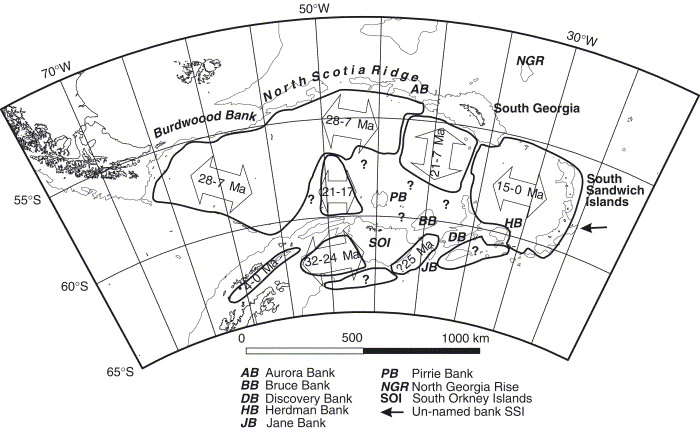
Summary of ocean floor ages and directions of opening in the Scotia Sea region from Tectonic Map (1985), updated from Lawver et al. (1991), Barker (1995), King et al. (1997) and elsewhere. Areas of likely oceanic crustal structure but unknown age are marked Ў░?Ў▒. Ridge crests and transforms of active or known abandoned spreading systems are shown as a grey dashed line. Actively subducting trenches are marked in Fig. 1. The 2000-m isobath and coastline are as in Fig. 1B. |
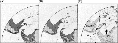
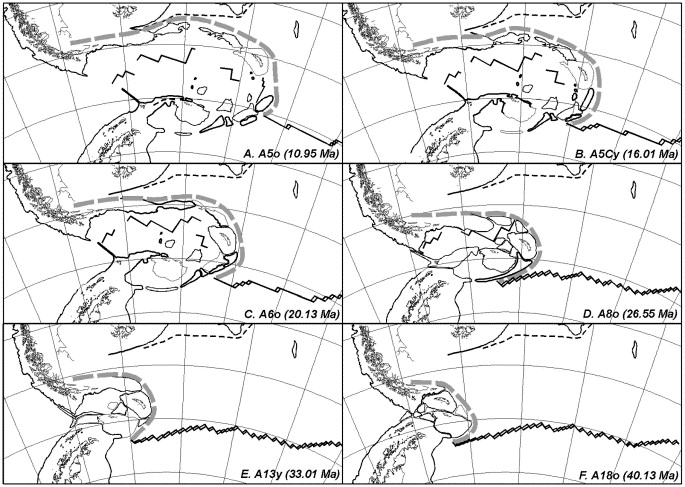
(AЁCF). Reconstructions of Scotia Sea tectonic evolution at six times within the last 40 Ma, drawn with respect to a fixed South America (Falkland Is., Falkland Plateau, Atlantic coast of Argentina). Magnetic anomaly ages from Cande and Kent (1995). Major components are identified by coastline and 2000-m isobath (as in Fig. 1 and Fig. 2). Also showing schematic trench (grey dashed line) and SAMЁCANT plate boundary, and trace of spreading centres where known. For a review of the data on which these reconstructions are based, see Section 3. |
Geology of continental fragments, as available from onshore outcrop and offshore marine geophysics, superimposed on the 40 Ma reconstruction of Fig. 3F (the Ў░fore-arc sandwichЎ▒, revised from King and Barker, 1988). Two provinces are distinguished: in dark grey the Pacific margin batholith and associated arc volcanics (where strongly magnetised, or mapped in outcrop), and in light grey a non-magnetic fore-arc and (partly relict but insitu) palaeo-forearc. The batholith has been mapped along the Antarctic Peninsula, South Orkney continent, part of the South Scotia Ridge and (possibly) within the South Sandwich forearc, on the southern margin of South Georgia and in Tierra del Fuego. Representative rocks of the palaeo-forearc occur on the Antarctic Peninsula margin, South Scotia Ridge, South Orkney Islands and western Tierra del Fuego. Most of South Georgia and (probably) the Shag Rocks block appear to have originated in the continental back-arc. Also shown are Pacific margin and Atlantic-directed subduction zones. The overall pattern of provinces is consistent with the model presented in Fig. 5. |
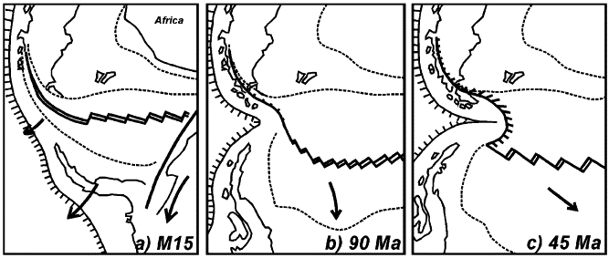
A model to explain the origins of east-directed subduction and accompanying back-arc extension in the Scotia Sea region (revised from and ). (a) Opening of the Rocas Verdes back-arc basin, continuing southeastward as separation of the Antarctic Peninsula (before South Atlantic opening), and with likely decoupling between the Antarctic Peninsula and East Antarctica. SAMЁCANTP pole of opening is to the northwest. (b) Closure of the Rocas Verdes basin, possibly from faster westward motion of South America, leading to formation of the Magallanes fold-thrust belt in southernmost South America. SAMЁCAFRЁCANT separations are well-established, and East Antarctica and the Antarctic Peninsula are probably by now a single plate. Pole of SAMЁCANT motion is close to the South AmericaЁCAntarctic Peninsula junction, leading to slow extension (slower westward) in the east and convergence in the Magallanes Basin to the northwest. The junction bends. (c) Continued motion as described in (b) bends the junction double. Whereas in the Magallanes foldЁCthrust belt to the north, convergence is limited by the presence of the South American continental foreland, farther south ocean floor is underthrust, presenting the opportunity for subduction to develop. |
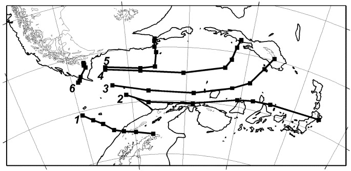
Flow lines of movement of six specific locations during Scotia Sea tectonic evolution over the past 40 Ma, with respect to a fixed South America, labelled 1ЁC6 (see text). Straight lines join the present-day locations to nodes extracted from Fig. 3AЁCF. Scotia Sea opening (involving line 2 and parts of 3ЁC5) was significantly faster than SAMЁCANT motion (line 1). |
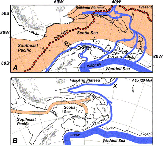
(A) Schematic diagram of present-day ocean circulation in the Scotia Sea region, showing in orange the Antarctic Circumpolar Current (ACC) flowing eastward into the Scotia Sea from the southeast Pacific, then spreading north and northeast over the Falkland Trough and Falkland Plateau, across the elevated North Scotia Ridge. The ACC is shown as a broad current, but the fastest flow (scouring the sea floor and preventing sediment deposition in places) is along the northernmost Drake Passage, then across the North Scotia Ridge and Falkland Plateau. Red circles mark the mean position of the Polar Front (Moore et al., 1997). See text for details. Weddell Sea Deep Water (WSDW, shown in blue) escapes northward from the Weddell Gyre into the Scotia Sea, through gaps and over sills along the South Scotia Ridge. Some WSDW flows west along the South Scotia Ridge and South Shetland fore-arc into the southeast Pacific. Other WSDW flows north and northeast across the East Scotia Sea, beneath the ACC, to join WSDW and Weddell Sea Bottom Water (WSBW) that has flowed north along the South Sandwich trench. WSDW flows in a narrow westward loop along the Falkland Trough before continuing north into the Southwest Atlantic. Of these water masses, the main ACC transport (ca. 130 Sv) is far greater than any of the others. (B) The reconstruction of Fig. 3C (to Anomaly 6o, about 20 Ma) with superimposed the likely pathways for the same major currents as shown schematically in (A) above. The ACC cannot yet develop, if Aurora and Davis Banks were elevated parts of the North Scotia Ridge, despite the gap at the Shackleton Fracture Zone (SFZ). Note also that the mid-ocean ridge crest in the western Scotia Sea (Drake Passage) was more elevated than today, because spreading was then active, and was closer to the North Scotia Ridge, therefore more directly within the path of the ACC and a possible impediment to rapid flow. Also more elevated than today was the AntarcticЁCPhoenixЁCFarallon (Nazca) spreading system in the SE Pacific, although its precise location is poorly known. Northward flow of southern-origin bottom water (SOBWЎЄnot necessarily having the same properties as modern WSDW) is largely unaffected (other than by the absence of the ACC), but flow westward into the southeast Pacific is unlikely. Ў░XЎ▒ marks where SOBW-influenced sediment may be sampled closest to the SOBW source. |
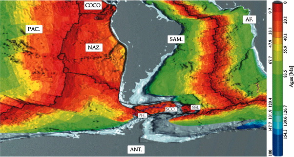
Age of the ocean floor for the South AmericaЁCAntarctica plate system from Mьller et al. (1997); poster cut off after Sloss (1996). Intervening plates are: PAC., Pacific; COCO., Coco; NAZ., Nazca; ANT., Antarctica (PH., Phoenix, now belonging to the Antarctica plate); SCO., Scotia; SSI., South Sandwich Islands; SAM., South America; AF., Africa http://www.sciencedirect.com/science/article/pii/S0264370711000846 |
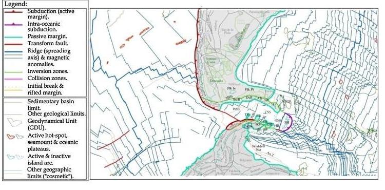
Present-day reconstruction with geodynamical units (GDUs) with magnetic anomalies of M¦оller et al. (2008). Written in grey are the names of most intervening GDUs. However, the paper focuses on GDUs with the following abbreviations: AB, Aurora Bank; BB, Bruce Bank; BwB, Burdwood Bank; DB, Discovery Bank; DvB, Davis Bank; DvBs, Dove Basin; HB, Herdman Bank; JBk, Jane Bank; JBs, Jane Basin; PB, Pirie Bank; PtBs, Protector Basin; PwBs, Powell Basin; SG, South Georgia; SO, South Orkney; SR, Shag Rocks; SSI, South Sandwich Islands; TR, Terror Rise. Also, An.V and An.T: Ў«V-ЎЇ and Ў«T-ЎЇmagnetic anomalies in the Weddel Sea; Flk Is, Falkland Islands; Flk Pt, Falkland Plateau; MFft, MagallanesЁCFagnano Fault; IOR, Islas Orcadas Rise; NEGR, North-East Georgia Rise; ESS, East Scotia Sea; ESSR, East Scotia Sea Rise; WSS, West Scotia Sea. Written in green are names of cratons. Orthogonal projection centred on the Falkland Islands. (For interpretation of the references to color in this figure legend, the reader is referred to the web version of the article.) |
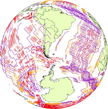
Purple lines correspond to magnetic anomalies (isochrons) as defined by [0205] and [0210]. All other segments correspond to magnetic anomalies (chrons) from the IHS dataset (personal communication) compiled worldwide from the literature. In grey, non-dated chrons; in orange, dated chrons not used in this study (>33 Ma); in red, used dated chrons (ЎЬ33 Ma). Orthogonal projection, centred on the Falkland Islands. (For interpretation of the references to color in this figure legend, the reader is referred to the web version of the article.) |
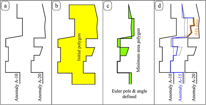
Sketches showing the technique employed in this study to define new synthetic magnetic anomaly. The example shows the definition of an arbitrary anomaly A-15 from anomalies A-10 and A-20 as given by Mьller et al. (2008). Anomaly A-15 is an average line of A-10 and A-20 where no other data is available, and fit the IHS segments where possible. Note that all calculations are carried out on the sphere (the æpolygonÆ, in particular, is actually a æspherical polygonÆ). |
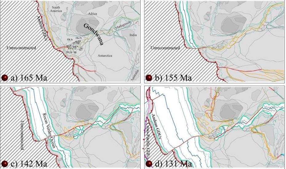
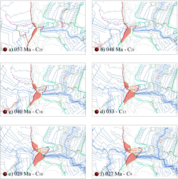
(a¢d) Geodynamical reconstructions from 165 Ma to 131 Ma. Grey: continental parts; darker grey: cratons. Orthogonal projection. (e¢h) Geodynamical reconstructions from 121 to 095 Ma. (i¢l) Geodynamical reconstructions from 084 to 048 Ma. (m and n) Geodynamical reconstructions from 040 to 033 Ma (abbreviations as per Fig. 2). |
(a¢d) Geodynamical reconstructions from 033 Ma to 026 Ma. Orthogonal projection. (e¢h) Geodynamical reconstructions from 020 to 016 Ma. f2 is a 3D sketch at 20 Ma aiming to clarify how driving forces act on the upper plate and lead to the formation of a double spreading ridge system. Grey dashed curves on the South America (SAM) plate are merely drawn to highlight the shape of the plate, and in particular, its curved downgoing slab. (h¢k) Geodynamical reconstructions from 013 to 006 Ma. (1¢o) Geodynamical reconstructions from 005 Ma to 000 Ma (abbreviations as per Fig. 2).http://www.sciencedirect.com/science/article/pii/S0264370711000846 |
The study of the South Scotia Ridge on the basis of swath bathymetry, multichannel seismic and magnetometry profiles, obtained during the HESANT92/93 cruise and complemented with satellite gravimetry and seismicity data illustrates the tectonics of the region. The thinned continental crust fragments of the ridge are bounded by oceanic crust of the Scotia Sea to the North and Powell Basin to the South. The northern boundary represents the contact between the Scotia and Antarctic plates. This boundary is a sinistral transpressional fault with transtensional segments and moderate recent tectonic activity. Another fault located at the southern boundary appears inactive and does not reveal any features that would enable the kinematics to be determined. Both faults have associated steep scarps since they separate oceanic and continental crust types.The most significant active deformation lies in the axial depression of the ridge, within a band delineated by fault systems with WSW-ENE and SW-NE strikes. These faults develop pull-apart basins, which separate the northern and southern blocks of the ridge. The northern block is being fragmented from the Antarctic Plate by a zone of transtensive faults, and is probably a crustal element independent of the Antarctic Plate. The axial depression, which crosses the ridge slightly obliquely, is characterized by deep basins locally more than 5000 m deep and associated high seismicity. The fault geometry and earthquake focal mechanisms indicate an active sinistral transtensive regime for the fault system, although it may locally have transpressive regimes depending on the fault plane and the stress field orientations. The internal basins are characterized by an asymmetric development showing itself as depositional wedges generally thickening northward. Deposits onlap the southern margins and are affected by normal faults in the northern margins. The seismicity around the Scotia Plate shows that the present stresses are compressive along the northern boundary with the South American Plate (σ1 SW-NE and subhorizontal) and along the western boundary with the Antarctic Plate (σ1 WNW-ESE and subhorizontal). For the South Scotia Ridge, however,σ1 is steeply inclined andσ3 is subhorizontal with a NW-SE trend. The stress distribution in Bransfield Strait is similar to the ridge and the recent extension could be partially explained by the westward continuation of the active fault system of the central South Scotia Ridge. The fragmentation of continental crustal blocks, due to the tectonic activity along the transcurrent plate boundaries, is a mechanism that contributes to the deformation of the northeastern end of the Antarctic Peninsula. This area appears appropriate for the analysis of continental plate fragmentation processes http://www.sciencedirect.com/science/article/pii/0040195195002111 |
http://whatonearth.olehnielsen.dk/plates/scotia.asp |
http://whatonearth.olehnielsen.dk/antarcticc.asp |
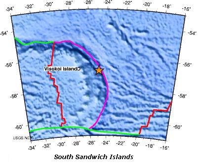
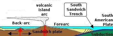
Sandwich plate - http://whatonearth.olehnielsen.dk/plates/sandwich.asp |
Sandwich plate http://whatonearth.olehnielsen.dk/plates/sandwich.asp |
Sandwich plate |
http://www.sciencedirect.com/science/article/pii/S0012821X05008411
http://www.sciencedirect.com/science/article/pii/S0012821X02009597
http://www.sciencedirect.com/science/article/pii/S0967064504001407
Scotia Sea regional tectonic evolution: implications for mantle flow and palaeocirculation
The Scotia Sea and surrounding Scotia Arc have evolved over the past 40 Ma, by extension behind an east-migrating subduction zone, at the boundary between the South American (SAM) and Antarctic (ANT) plates. The considerable data set now available (regional geology and geophysics, earthquake seismology, satellite altimetry, global plate analyses) suggest why east-migrating subduction began, what has been the driving force that has sustained it, and what other processes have controlled the mode of back-arc extension in the Scotia Sea. A suite of six reconstructions has been developed, based on this data set. The reconstruction to 40 Ma creates a compact, cuspate continental connection between South America and the Antarctic Peninsula at the subducting Pacific margin, with fragments (now dispersed around the Scotia Arc) occupying positions within it compatible with their known geology. The driving force has been subduction of South American ocean floor, which began as a result of southward migration of the pole of South AmericanЁCAntarctic plate rotation, and a key modulator of back-arc extension has been collision of ridge crest sections of the South AmericanЁCAntarctic plate boundary with the east-advancing trench. Cenozoic regional tectonic evolution has two other likely consequences which greatly increase its importance. Firstly, this region saw the tectonic disruption of the final barrier to complete circum-Antarctic deep water flow, that may have had a profound effect on palaeoclimate. Secondly, it is possible that the rapid roll-back of the hinge of subduction is related to shallow eastward flow in the sub-lithospheric mantle. Both of these consequences are explored. The reconstructions show that rapid roll-back of the subduction hinge (averaging 50 mm/a over the last 40 Ma with respect to the South American plate) has been a feature of all of Scotia Sea evolution, and provide a history of motion of several oceanic microplates, most of which are now welded together within the Scotia Sea. This will guide the location of seismometers and/or dredge hauls to test the hypothesis of shallow mantle flow, and help interpret the results. The reconstructions also allow an assessment of the creation of deep-water pathways that would have permitted the development of the present-day Antarctic Circumpolar Current (ACC). An early Miocene onset (within the period 22ЁC17 Ma) seems likely for the ACC, depending on the structure and palaeo-elevation of Davis Bank and Aurora Bank, sections of the North Scotia Ridge. However, the study shows there was a delay (of one or more million years) between initial provision of a deep-water pathway and the major mid-Miocene change in global climate (involving the general level of Antarctic glaciation) that may have been related. If these changes were related, then the delay suggests that other factors, possibly rough elevated ocean floor but also non-tectonic factors (such as atmospheric CO2), were important in determining palaeoclimatehttp://www.sciencedirect.com/science/article/pii/S0012825201000551
Within the Scotia Sea, the axis of the Antarctic Circumpolar Current (ACC) is geographically confined, and sediments therefore contain a record of palaeo-flow speed uncomplicated by ACC axis migration. We outline Holocene and Last Glacial Maximum (LGM) current-controlled sedimentation using data from 3.5-kHz profiles, cores and current meter moorings. Geophysical surveys show areas of erosion and deposition controlled by Neogene basement topography. Deposition occurs in mounded sediment drifts or flatter areas, where 500ЁC1000 m of sediment overlies acoustic basement. 3.5-kHz profiles show parallel, continuous sub-bottom reflectors with highest sedimentation rates in the centre of the drifts, and reflectors converging towards marginal zones of non-deposition. Locally, on the flanks of continental blocks (e.g. South Georgia), downslope processes are dominant. The absence of mudwaves on the sediment drifts may result from the unsteadiness of ACC flow. A core transect from the ACC axis south to the boundary with the Weddell Gyre shows a southward decrease in biogenic content, controlled by the Polar Front and the spring sea-ice edge. Both these features lay farther north at LGM. The cores have been dated by relative abundance of the radiolarian Cycladophora davisiana, and by changes in the biogenic Ba content, a palaeoproductivity indicator. Sedimentation rates range from 3 to 17 cm/ka. The grain size of Holocene sediments shows a coarsening trend from south to north, consistent with strongest bottom-current flow near the ACC axis, though interpretation is complicated by the presence of biogenic grains. Year-long current meter records indicate mean speeds from 7 cm/s in the south to 12 cm/s in the north, with benthic storm frequency increasing northwards. LGM sediments are predominantly terrigenous and show a clearer northward-coarsening trend, with well-sorted silts in the northern Scotia Sea. Assuming a constant terrigenous source, this implies stronger ACC flow at the LGM, contrasting with weaker Weddell Gyre flow deduced from earlier workhttp://www.sciencedirect.com/science/article/pii/S0025322798000140
http://www.sciencedirect.com/science/article/pii/S0264370711000846 Geodynamic reconstructions of the South AmericaЁCAntarctica plate system
The South AmericaЁCAntarctica plate system shows many oceanic accretionary systems and subduction zones that initiated and then stopped. To better apprehend the evolution of the system, geodynamic reconstructions (global) have been created from Jurassic (165 Ma) to present, following the techniques used at the University of Lausanne. However, additional synthetic magnetic anomalies were used to refine the geodynamics between 33 Ma and present.
The reconstructions show the break up of Gondwana with oceanisation between South America (SAM) and Antarctica (ANT), together with the break off of Ў«AndeanЎЇ geodynamical units (GDUs). We propose that oceanisation occurs also east and south of the Scotian GDUs. Andean GDUs collide with other GDUs crossing the Pacific. The west coast of SAM and ANT undergo a subsequent collision with all those GDUs between 103 Ma and 84 Ma, and the Antarctic Peninsula also collides with Tierra del Fuego. The SAMЁCANT plate boundary experienced a series of extension and shortening with large strike-slip component, culminating with intra-oceanic subduction leading to the presence of the Ў«V-ЎЇ and Ў«T-ЎЇ anomalies in the Weddell Sea. From 84 Ma, a transpressive collision takes place in the Scotia region, with active margin to the east. As subduction propagates northwards into an old and dense oceanic crust, slab roll-back initiates, giving rise to the western Scotia Sea and the Powell Basin opening. The Drake Passage opens. As the Scotian GDUs migrate eastwards, there is enough space for them to spread and allow a northЁCsouth divergence with a spreading axis acting simultaneously with the western Scotia ridge. Discovery Bank stops the migration of South Orkney and Ў«collides withЎЇ the SAMЁCANT spreading axis, while the northern Scotian GDUs are blocked against the Falkland Plateau and the North-East Georgia Rise. The western and central Scotia and the Powell Basin spreading axes must cease, and the ridge jumps to create the South Sandwich Islands Sea. The Tierra del FuegoЁCPatagonia region has always experienced mid-oceanic ridge subduction since 84 Ma. Slab window location is also presented (57ЁC0 Ma), because of its important implication for heat flux and magmatism.
The opening of oceanic basins constitutes one of the key features of Plate Tectonics because it determines the rifting and displacement of the continental crustal blocks. Although the mechanisms of development of large oceans are well known, the opening and evolution of small and middle size oceanic basins have not been studied in detail. The Protector Basin, located in the southern Scotia Sea, is a good example of a small oceanic basin developed between two thinned continental blocks, the Pirie Bank and the Terror Rise, poorly studied up to now. A new set of multibeam bathymetry, multichannel seismic reflection, and gravity and magnetic anomaly profiles obtained on the SCAN 2001 cruise led us to determine that the Protector Basin probably opened during the period comprised between C5Dn (17.4 Ma) and C5ACn¢C5ABr chrons (13.8 Ma), forming a N¢S oriented spreading axis. The end of spreading is slightly younger to the north. The start of spreading is clearly diachronous, with the most complete set of chrons up to C5Dn in the southern profile, C5Cn in the middle section and only up to C5ADn in the northern part of the basin. The spreading axis propagated northwards during the basin development, producing the wedge shape of the basin. In addition, at the NE part of the basin, a reverse fault developed in the border of the Pirie Bank after basin opening accentuates the sharp northern end. Moreover, the northwestern part of the Pirie Bank margin is an extremely stretched continental crust with N¢S elongated magnetic anomalies related to incipient oceanic southward propagating spreading axes. The Protector Basin shows the oldest evidence of E¢W continental stretching and subsequent oceanic spreading during Middle Miocene, related with the eastward development of the Scotia Arc that continues up to Present. The relative rotation of continental blocks during the development of small sized oceanic basins by continental block drifting favoured the opening of wedge shape basins like the Protector Basin and conjugate propagating rifts.http://www.sciencedirect.com/science/article/pii/S0012821X05008289
Multichannel seismic reflection profiles recorded aboard B/O Hespķrides during the austral summer of 1991¢1992 were used to identify the tectonic style of the South Scotia Ridge along the Scotia/Antarctica plate boundary. The ridge is composed of continental crustal fragments transported eastward from the South America-Antarctic isthmus 28 to 6 Ma during the opening of Drake Passage. It is made up of two highs (north and south branches of the South Scotia Ridge) separated by a central depression that contains four narrow deeps. Fragmentation of the ridge during and since its transport to its present position is due to transtensional sinistral motion along the Scotia-Antarctic plate boundary. This fragmentation of the ridge appears to have been in two phases. During an early phase of transtension, which probably took place in the Oligocene, a half graben fronted by a high along its northern edge was formed along the southern flank of the ridge. Concurrent with this transtension episode an extensive sediment prism was deposited north of the ridge. The second tectonic episode during which the present plate boundary was established in its current location along the central depression may have begun about 4 Ma. Transtensional tectonics along the sinistral transform fault plate boundary during this phase led to the creation of the present tectonic geomorphology of the South Scotia Ridge. Extension during this phase is characterized by listric faults dipping both north and south which root into a northerly dipping basal detachment surface. Motion along these faults caused the block above the detachment surface (upper blockŚnorth branch of the South Scotia Ridge) to undergo some degree of tilting. Differences in morphology along the north branch suggest that this block tilting varies along strike being the least on its eastern and western ends and maximum in the center. This suggests that continuity of the listric faults parallel to the plate boundary is disrupted by transverse structures, structures which may have been produced by bends along the plate boundary. As the blocks were transported laterally along the transtensional sinistral plate boundary they experienced some degree of counterclockwise rotation along the right lateral transverse structures creating local zones of compression and extension at their corners. It is this compression created by the rotating blocks which led to the deformation of the sediments north of the eastern end of the north branch of the South Scotia Ridge and within the central depression itself.
http://www.sciencedirect.com/science/article/pii/S004019519600090X
The study of the South Scotia Ridge on the basis of swath bathymetry, multichannel seismic and magnetometry profiles, obtained during the HESANT92/93 cruise and complemented with satellite gravimetry and seismicity data illustrates the tectonics of the region. The thinned continental crust fragments of the ridge are bounded by oceanic crust of the Scotia Sea to the North and Powell Basin to the South. The northern boundary represents the contact between the Scotia and Antarctic plates. This boundary is a sinistral transpressional fault with transtensional segments and moderate recent tectonic activity. Another fault located at the southern boundary appears inactive and does not reveal any features that would enable the kinematics to be determined. Both faults have associated steep scarps since they separate oceanic and continental crust types.
The most significant active deformation lies in the axial depression of the ridge, within a band delineated by fault systems with WSW-ENE and SW-NE strikes. These faults develop pull-apart basins, which separate the northern and southern blocks of the ridge. The northern block is being fragmented from the Antarctic Plate by a zone of transtensive faults, and is probably a crustal element independent of the Antarctic Plate. The axial depression, which crosses the ridge slightly obliquely, is characterized by deep basins locally more than 5000 m deep and associated high seismicity. The fault geometry and earthquake focal mechanisms indicate an active sinistral transtensive regime for the fault system, although it may locally have transpressive regimes depending on the fault plane and the stress field orientations. The internal basins are characterized by an asymmetric development showing itself as depositional wedges generally thickening northward. Deposits onlap the southern margins and are affected by normal faults in the northern margins.
The seismicity around the Scotia Plate shows that the present stresses are compressive along the northern boundary with the South American Plate (σ1 SW-NE and sub
Propagating rift during the opening of a small oceanic basin: The Protector Basin (Scotia Arc, Antarctica)
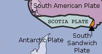
Scotia plate
Sandwich plate