 | Taiwan -Luzon arc-continent collision system |
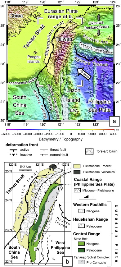
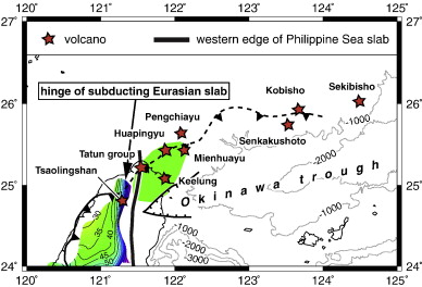
(a) Plate tectonic setting around the TaiwanззCLuzon arc-continent collision. The transition from active to inactive deformation front in northern Taiwan is after Teng et al. (2001), its offshore continuation after Hsiao et al. (1998). (b) Simplified tectonic map of Taiwan. Converging arrows labeled Ў®LVЎЇ depict the Longitudinal Valley. |
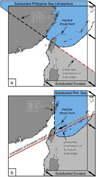
Models of subduction polarity reversal proposed for Taiwan. (a) Instantaneous polarity reversal at a trenchззCtrench transform, and (b) progressive polarity reversal by propagating a tear in the Eurasian lithosphere along the edge of the continent. front http://www.sciencedirect.com/science/article/pii/S0040195111005385 |
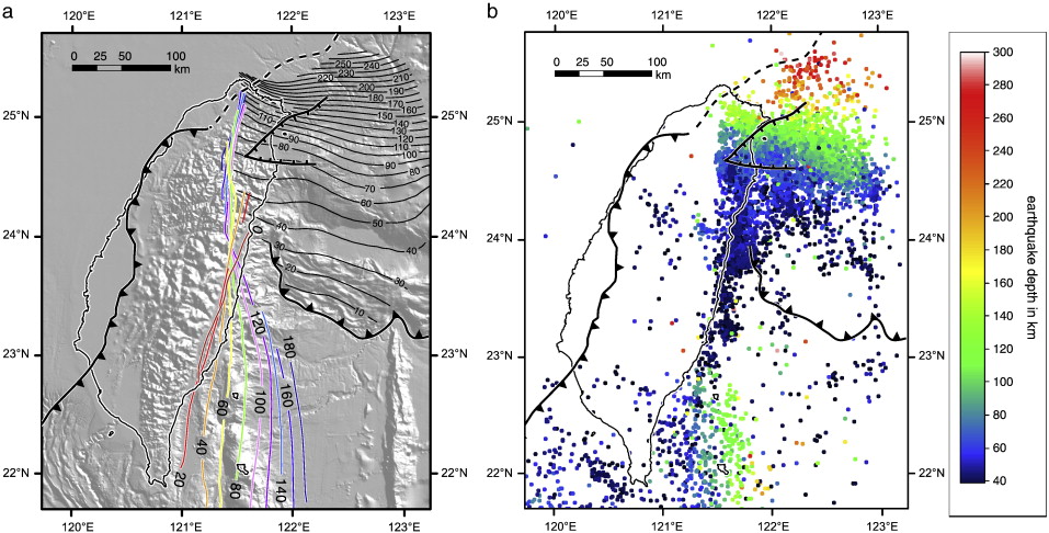
(a) Color-coded contours indicate an isovelocity surface of Vp = 7.5 km s− 1 from the tomographic grid, corresponding to the plate interface separating the Eurasian lower crust (Vp < 7.5 km s− 1) from the Philippine Sea lithosphere (Vp Ўз┐ 7.5 km s− 1). At depths greater than c. 100 km the plate interface continues as the top of the subducting Eurasian slab. The surface changes its dip direction along-strike from east-dipping in the south to essentially vertical in the north. The 0 km contour follows the Longitudinal Valley. Black contours depict the north-dipping Philippine Sea plate slab, constructed from fitting a regression surface through the Benioff zone (shown in b). Contours in this and all consecutive maps are labeled in km. (b) Earthquakes with M Ўз┐ 3.0 and a hypocenter depth Ўз┐ 40 km (Wu et al., 2008a). The clear-cut western edge of seismicity is confined to the northward dipping Philippine Sea plate and abuts the plate interface as constrained from tomography. |
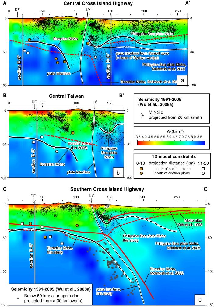
Cross sectional views of plate interfaces and Moho surfaces derived in this study in comparison to previously published data. Sections AиCAбф to DиCDбф (a to d) traverse the thrust belt at high angle. AиCAбф to CиCCбф are parallel to various geophysical transects. Section EиCEбф (e) is parallel to a set of geological cross sections through the westernmost Foothills Thrust Belt (from Huang et al., 2004). (f) Location map of the sections. Scale is in kilometers. The Moho is dashed, where constrained by less than 500 (Eurasia) and 5000 (Philippine Sea plate) p-wave readings (compare Figs. 8b and 9b). боCFбп = Chihshang fault, боDFбп = deformation front, боLVбп = Longitudinal Valley. |
Position of the post-collisional North Taiwan volcanic province (after and ) in relation to the deformation front and some crustЦmantle boundaries derived in this study. The volcanoes terminate at the western confinement of the north-dipping Philippine Sea slab and are underlain by a subhorizontal Moho. The transition from the active to the inactive segment of the deformation front (after Hsiao et al., 1998) coincides with the hinge of the subducting Eurasian slab at the level of the Moho. In combination, this suggests a progressive deactivation of the deformation by the westward encroachment of the Philippine Sea slab. |
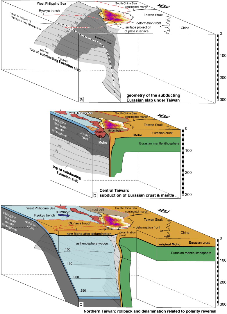
Schematic lithosphere-scale block diagrams illustrating along-strike changes in the geometry of various crustЦmantle boundaries under Taiwan, mapped in this study. The margins of the block domains trend NЦS and EЦW, respectively. Depth is given in km. (a) Geometry of the plate interface separating the Eurasian and Philippine Sea plates. The plate interface progressively steepens from south to north. (b) Section through central Taiwan at c. 24░N, where the subducting Eurasian slab is vertical. A thickness of 100 km is assumed for both the Eurasian and Philippine Sea plates. (c) Section at the northern tip of Taiwan, illustrating the rollback and delamination of the subducting Eurasian lithosphere. This creates the space required for the Philippine Sea plate to subduct northward. The deactivation of the deformation front occurs at the hinge of the subducting and delaminating Eurasian lithosphere. The shallow asthenosphere wedge east of the delamination front provides the source for the north Taiwan volcanoes (in gray). |
Crust -mantle boundaries in the Taiwan -Luzon arc-continent collision system determined from local earthquake tomography and 1D models: Implications for the mode of subduction polarity reversal. In order to better understand the mode of subduction polarity reversal in the TaiwanззCLuzon arc-continent collision zone, we mapped its crustззCmantle boundaries using local earthquake tomography. By contouring surfaces of constant Vp = 7.5 km/s, we identified three Moho discontinuities and the plate interface that juxtaposes Eurasian lower crust against mantle lithosphere of the Philippine Sea plate. The plate interface dips to the east under southeastern Taiwan and steepens progressively towards north until it becomes vertical at 23.7Ўз╘N. From there it continues northward in a vertical orientation, until the limit of the tomographic model inhibited further mapping. For the Moho, additional depth constraints were derived from 1D models using P-wave arrivals of local earthquakes. The Mohos of the Eurasian and Philippine Sea plates are disconnected across the plate interface. Beneath southern Taiwan, the Eurasian Moho dips to the east at 50ззC60Ўз╘, following the orientation of the plate boundary and continuous with the Benioff zone. Towards north, the Eurasian Moho steepens into subvertical, again together with the plate boundary. The Philippine Sea plate Moho exhibits a synform-like crustal root, interpreted as the base of the magmatic Luzon arc. Towards the north, this root deepens from 30 to 70 km underneath the Ryukyu trench. In northernmost Taiwan, the hinge of the vertically subducting Eurasian slab steps westward out of the thrust belt, leaving the deformation front to the east inactive and giving way to the north-dipping Philippine Sea plate. A subhorizontal Moho at 30ззC35 km depth overlies the north-dipping Philippine Sea slab and is interpreted as a newly formed Moho, established after westward rollback and delamination of the subducting Eurasian slab. In combination, these data support a model of progressive subduction polarity reversal, in which a tear within the Eurasian lithosphere propagated southwestward, deactivating the deformation front
c http://www.sciencedirect.com/science/article/pii/S0040195111005385
Mapping the subductioin zone beneath Taiwan. The island of Taiwan (Formosa) sits on the boundary between two tectonic plates the Eurasian and the Philippine Sea. To the south of the Island the Manila Trench, in which the Eurasian Plate is being subducted beneath the Philippine Sea Plate, extends southward to the Philippines. To the east the Ryuku Trench, in which the Philippine Sea Plate is being subducted beneath the Eurasian, extends northeast to Japan. Taiwan forms part of two island-arcs, the Ryukyu Arc, which is formed volcanically from material which is subducted in the Ryuku Trench, melted by the heat of the Earth''s interior, then rises through the overlying Eurasian plate to form volcanic islands, and the Luzon Arc on which melted material from the subducting Eurasian Plate is rising through the overlying Philippine Sea Plate. In a forthcoming paper http://www.sciencedirect.com/science/article/pii/S0040195111005385 in the journal Tectonophysics, a team of scientists lead by Kamil Ustaszewski of the Lithosphere Dynamics Section at the Helmholtz Centre Potsdam German Research Centre for Geosciences describe how they built up a map of the geological structure underneath Taiwan, using Earthquake tomography, a technique that uses vibrational waves created by natural earthquakes (of which there are quite a lot in Taiwan) to create a three dimensional picture in the same way that a sonar uses artificially generated sound waves. revealed that the Eurasian Plate is folded sharply beneath the Island along a north-south line bisecting the island and sinking into the Earth at close to 90░. The Philippine Sea Plate is moving past this, being pushed northwards by an extension centre (ocean ridge) to the south. Towards the north end of the island the Philippine Sea Plate is itself being subducted, at a less steep angle, beneath an accretionary prism made up of material that is not easily subducted, such as old volcanic islands that have been dragged along by the moving plate. This prism has become annealed to the Eurasian plate, forming an new section of continental lithosphere, complete with an emerging Mohorovicic Discontinuity, the upper part of this being covered by sediment, is indistinguishable from the older Eurasian crust, leading to the illusion of two tectonic plates being subducted beneath one-another in the same place. http://sciencythoughts.blogspot.co.uk/2012/02/mapping-subductioin-zone-beneath-taiwan.html