 | Seismity. THE TRANSVERSE RANGES |
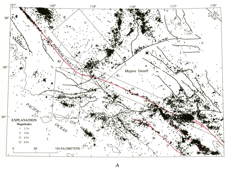
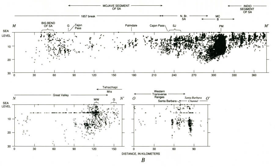
Seismicity in the southern Coast Ranges and Transverse Ranges. A, Earthquake locations, showing major branches of the San Andreas fault system in red; faults dotted where concealed. Magnitude symbols shown in explanation are scaled with enlargement of cross sections. C, Cholame; CP, Cajon Pass; P, Parkfield; PI, Palmdale; SB, Santa Barbara; 5MB, Santa Monica Bay; TP, Tejon Pass. B, Depth sections outlined in figure 5.9A. Faults: B, Banning; G, Garlock; MC, Mission Creek; N.Br.SA, northern branch of the San Andreas; PM, Pinto Mountain; SA, San Andreas, SJ, San Jacinto; WW, White Wolf. http://geologycafe.com/california/pp1515/chapter5.html |
Seismicity in the southern Coast Ranges and Transverse Ranges. A, Earthquake locations, showing major branches of the San Andreas fault system in red; faults dotted where concealed. Magnitude symbols shown in explanation are scaled with enlargement of cross sections. C, Cholame; CP, Cajon Pass; P, Parkfield; PI, Palmdale; SB, Santa Barbara; 5MB, Santa Monica Bay; TP, Tejon Pass. B, Depth sections outlined in figure 5.9A. Faults: B, Banning; G, Garlock; MC, Mission Creek; N.Br.SA, northern branch of the San Andreas; PM, Pinto Mountain; SA, San Andreas, SJ, San Jacinto; WW, White Wolf. |
see http://plate-tectonic.narod.ru/califcrustseismphotoalbum.html
THE 1857 BREAK AND THE TRANSVERSE RANGES
The 1857 rupture of the San Andreas fault began near Parkfield at the south end of the creeping section of the fault and propagated southeastward along the straight segment, through the Carrizo Plain and around the Big Bend near Tejon Pass, and thence along the relatively straight, east-southeastward trend of the Mojave segment to Cajon Pass, where the San Jacinto fault branches to the south Right-lateral offsets associated with this great earthquake generally decreased from 9 m along the Carrizo Plain segment, through 6 m around Fort Tejon, to 3-4 m along the Mojave segment (Sieh, 1978).
The pronounced bends in the San Andreas fault at either end of the east-southeast-trending Mojave segment involve strong structural complexities and clusters of persistent seismic activity. Both bends, for example, spawn major left-lateral faults that form conjugate sets to the San Andreas system. Sykes and Seeber (1985) proposed that these two major bends in the San Andreas fault system represent large-scale asperities that exert a strong influence on the rupture patterns of great earthquakes along the San Andreas fault in southern California. The San Andreas fault appears to maintain its integrity as a single, more or less continuous zone through the 30бу bend at Fort Tejon. Convergence resulting from the pronounced counterclockwise cant of the Mojave segment of the San Andreas fault (N. 66бу W.) with respect to the average N 37бу W. orientation of the transform boundary largely accounts for the crustal uplift and shortening expressed in the Transverse Ranges.
The straight Carrizo Plain segment is, except for a small cluster of events near Simmler (lat 35бу25'' N., long 120бу00'' W.), almost completely aseismic, much like the Point Arena segment of the 1906 break. The straight part of the Mojave segment also is seismically very quiet. The southernmost 80 km of the 1857 rupture zone produces few earthquakes, forming a sinuous lineation around the fault. Again, an analogy can be drawn with the 1906 rupture zone: The southernmost 80 to 100 km of the 1906 rupture, which exhibited less slip than the rupture zone farther north, also has a slightly higher background seismicity rate than that to the north. The Mojave earthquakes are temporally clustered (Sauber and others, 1983) and, because of their reverse focal mechanisms and displacement from the surface trace of the San Andreas, are thought to be on secondary fault structures rather than on the San Andreas fault itself.
Within the area of the Big Bend of the San Andreas fault near Tejon Pass, the level of seismicity is much higher than in the adjoining regions. Much of this activity is associated with the Pleito- White Wolf fault system, which abuts the San Andreas fault in the northern bend, some 40 km west of the junction with the Garlock-Big Pine faults (fig. 5.9A; cross sec. N-N'', fig. 5.9B; see fig. 5.12). The White Wolf fault ruptured in 1952 with the M=7.7 Kern County earthquake, accompanied by left-oblique reverse slip on a southeast-dipping fault plane (Richter, 1958; Stein and Thatcher, 1981). This is the largest earthquake to occur in California since the Mб╓8 San Francisco earthquake. In contrast to the quiescent 1906 rupture, however, the White Wolf fault continues to be marked by persistent aftershocks of the 1952 Kern County earthquake. The Garlock and Big Pine faults are essentially quiescent within 40 to 50 km of the San Andreas, although two small clusters of epicenters form a nearly symmetrical pattern on either side of the junction of these sinistral faults with the San Andreas.
Seismicity increases markedly near the south end of the 1857 rupture zone, where the San Jacinto fault and the east-west-striking Cucamonga fault, which forms the south front of the central Transverse Ranges, intersect the San Andreas fault. A bulbous lobe of epicenters extends westward along the Cucamonga fault from this junction. Scattered epicenters fill in the wedge of the Transverse Ranges between the Cucamonga and San Jacinto faults. The tight lineation of epicenters that appears to follow the trace of the Cucamonga fault westward to its intersection with the Elsinore fault (Chino branch). The significance of this lineation is unclear because the Cucamonga fault presumably dips north beneath the central Transverse Ranges (Morton, 1987).
The cross section along the Mojave segment of the San Andreas fault (M-M'') shows a wide variation in focal depths. The few events along the straight section of the Mojave segment are strongly clustered around depths of 10 km, with the maximum focal depth always above 15 km and almost no shallow earthquakes. This pattern is similar to the concentration of hypocenters in the lower half of the seismogenic crust beneath the locked 1906 segment (compare with cross sec. L-L,. In contrast, the earthquakes at Tejon Pass cover the full depth range from 0 to 25 km. At the southeast end of the 1857 rupture zone at Cajon Pass, maximum focal depths increase with the seismicity level to a maximum of 20 km. In this section, there are no shallow (less than 5 km deep) events.
Note, in particular, that focal depths of more than 20 km are broadly associated with the convergent tectonics of the Transverse Ranges; they are not limited to the seismicity clusters in the vicinity of the bends in the San Andreas fault system as might be inferred from cross section M-M'' . Cross sections N-N'' and 0-0'', the seismogenic crust reaches thicknesses of 20 to 25 km beneath the Santa Barbara Channel and the western Transverse Ranges, as well as beneath the Tehachapi Mountains to the east.

