 | ВЕНЕРА |
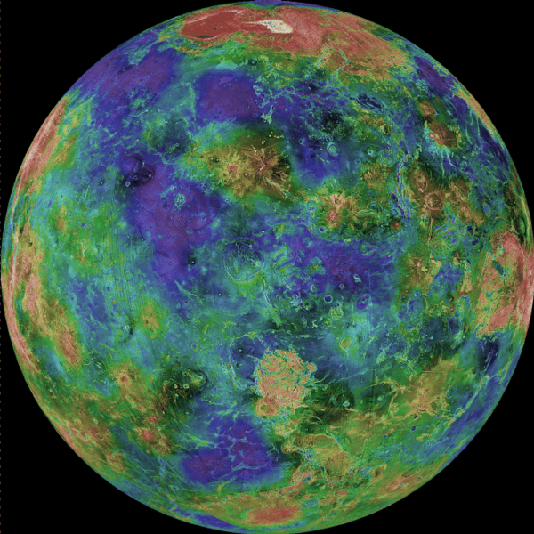
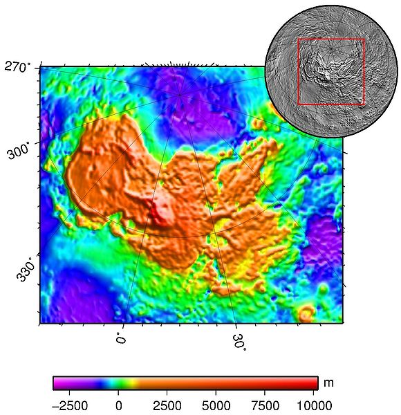
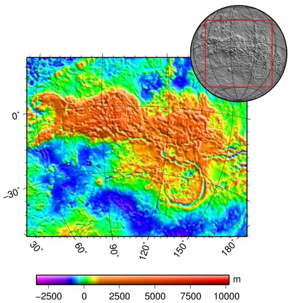
Magellan radar topographical map of Venus (false color)-http://en.wikipedia.org/wiki/Venus#Geography |
Map of Venus, showing the elevated "continents" in yellow: Ishtar Terra at the top and Aphrodite Terra just below the equator to the right -http://en.wikipedia.org/wiki/Venus#Geography |
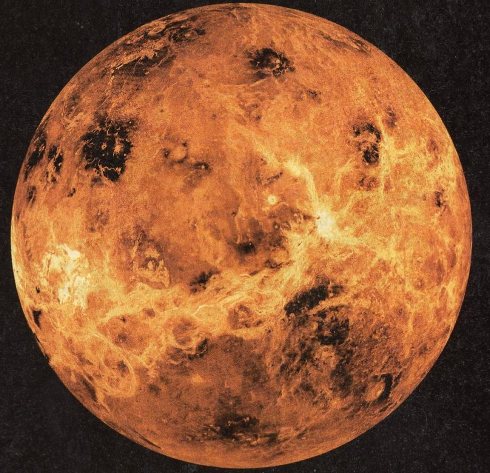
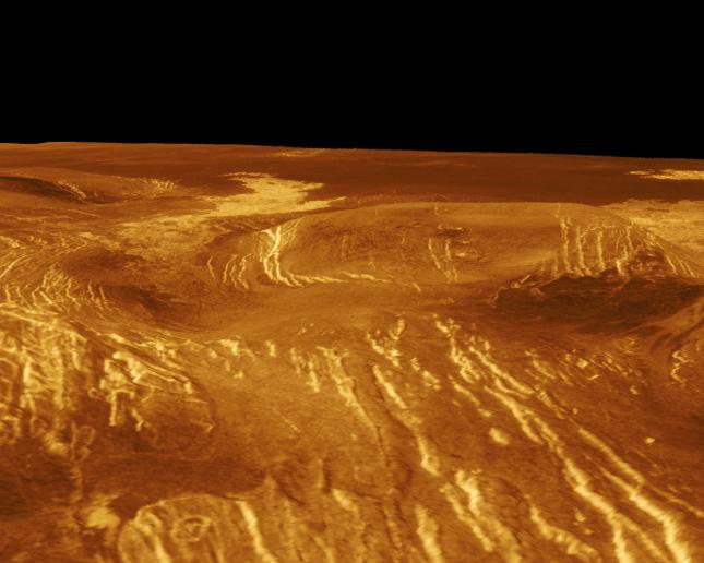
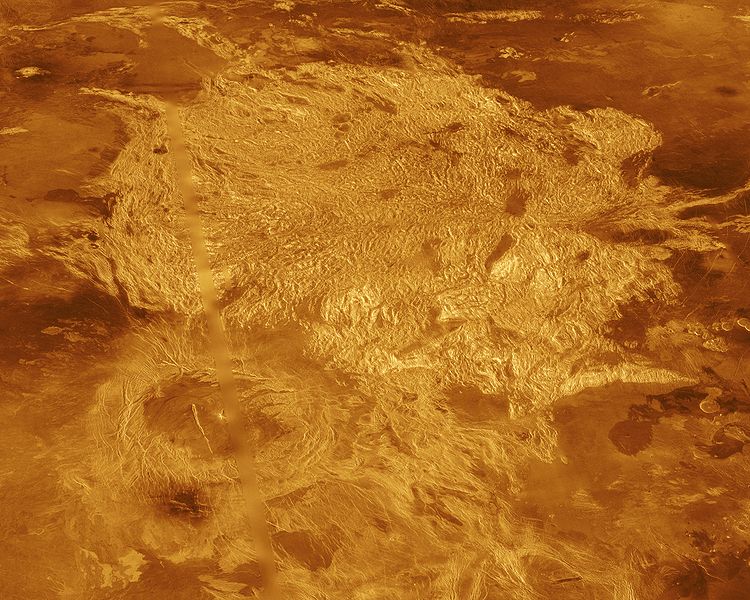
Этот вид Венеры создан в ходе двухлетнего проекта Magellan с помощью радарной картографии. Витьеватые светловатые объекты представляют собой горные местности и каньоны восточного нагорья Афродиты. This global view of Venis is computer generated from two years of Magellan project radar mapping. The twisting bright features that cross the globe ar highly fractured mountains and canyons of the eastern Aphrodite highland (NASA/JPL). |
Venus (northern hemisphere) |
Предполагаемое строение Венеры (иллюстрация Calvin J.Hamilton/NASA/ESA). |
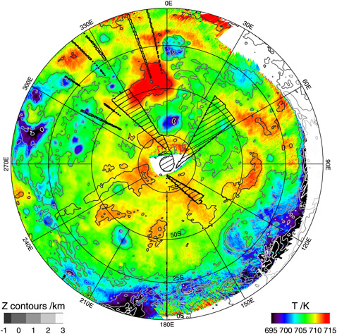
Новая тепловая карта южного полушария Венеры (иллюстрация ESA/VIRTIS/INAF-IASF/Obs. de Paris-LESIA). |
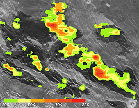
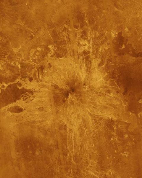
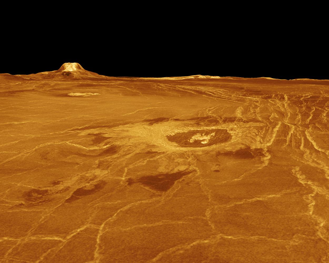
Старые вулканы на Венере есть, но существуют ли действующие – неизвестно. А ведь вулканизм, по одной из версий, и есть причина высочайшей концентрации углекислого газа в атмосфере и, следовательно, парникового эффекта. Венерa в микроволновом диапазоне (зонд Magellan). На снимке цвета обозначают превышение температуры застывших потоков над средней температурой местности ( Nataliya Bondarenko et al./GRL, UCSC).Поверхность Венеры «украшают» более тысячи вулканов, но является ли Венера такой же геологически активной, как Земля, или же успокоилась, как Марс.3астывшая лава региона Bereghinia Planitia северного полушария Венеры оказалась примерно на 85 °C горячее, чем ожидалось, возраст этих потоков не превышает нескольких десятилетий.Если бы лава извергалась лет сто назад, зонд Magellan попросту не смог бы её «увидеть». В статье, опубликованной в журнале Geophysical Research Letters, Бондаренко со товарищи предполагают, что извержение происходило более 15 лет назад. Прежде удавалось обнаружить следы лавовых потоков возрастом от 2,5 миллиона до 250 лет. Так, группа Сюзан Смрекар (Suzanne Smrekar) из Лаборатории реактивного движения рапортовала об исследовании таких «свежих» лавовых потоков в южном полушарии - http://www.membrana.ru/particle/4542 |
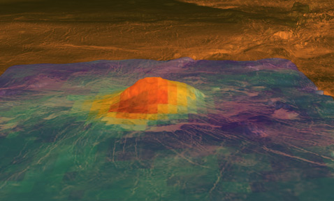
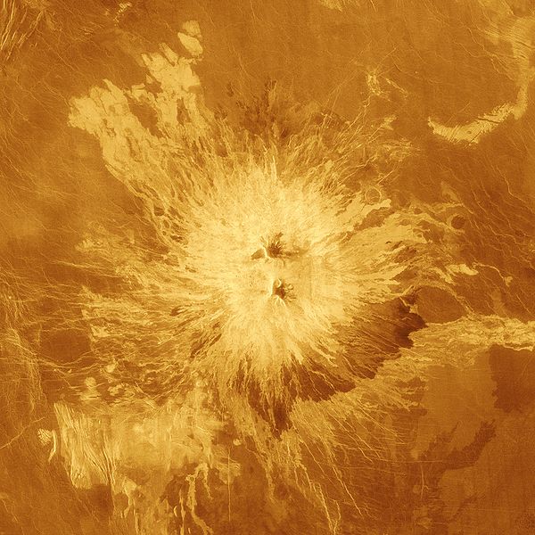
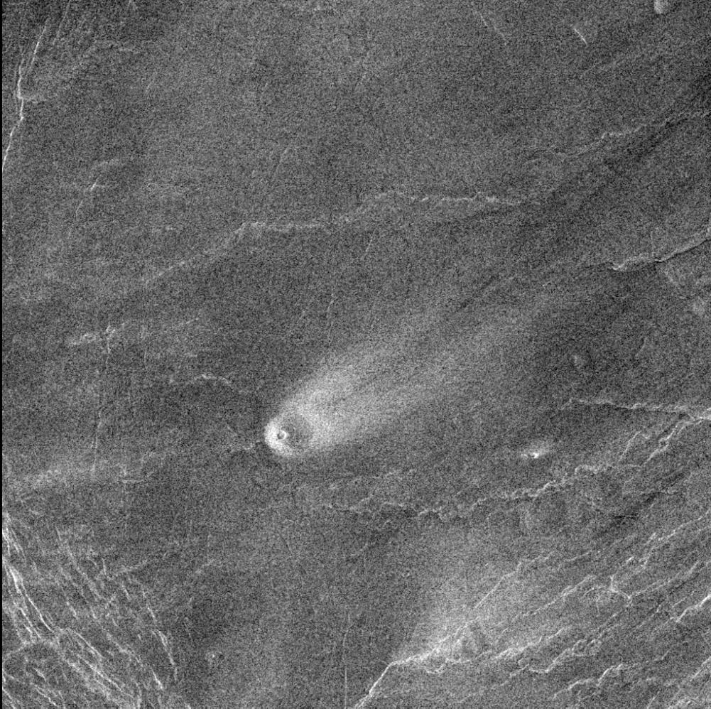
Одно из комбинированных изображений, полученных командой Suzanne Smrekar. Пик Idunn Mons. Высота этого элемента рельефа около 2,5 километра, а диаметр – 200 км (иллюстрация ESA/NASA/JPL).Bозможно присутствиe молодых вулканов на Венере, информация сo спектрометра VIRTIS, который способен разглядеть поверхность планеты сквозь толстый слой атмосферы, наполненной CO2-.http://sci.esa.int/science-e/www/object/index.cfm?fobjectid=46816 http://photojournal.jpl.nasa.gov/catalog/PIA13001 |
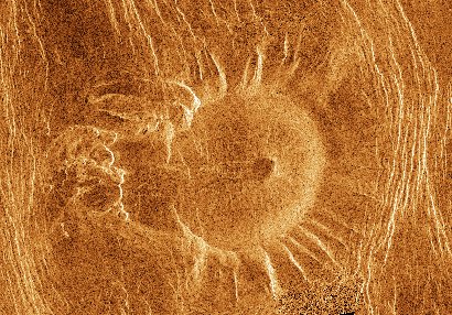
This Magellan radar image shows a type of volcanic feature known as a "tick", located northeast of Alpha Regio on Venus. These features are characterized by a caldera within a smooth depression surrounded by a raised rim with radial spurs. The rim in this case has a diameter of about 30 km - http://sci.esa.int/science-e/www/object/index.cfm?fobjectid=46809 The original scalloped margin dome: The Tick-A scalloped margin dome is a volcanic dome that has experienced collapse and mass wasting such as landslides on its perimeter. The margins of these domes have arcuate headscarps or ''scallops'' separated by ridges that are a consequence of adjoining scallops. Sometimes debris or slumping can be found at the bottom of these scarps or scattered many tens of kilometers away. Many examples show no debris at all. The center of these domes is often, but not always, a depression. There is another theory that the radial ridges of scalloped margin domes are volcanic dikes- http://en.wikipedia.org/wiki/Scalloped_margin_dome |
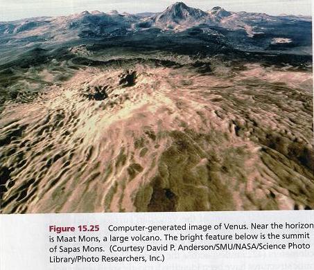
Sapas Mons is a large volcano located in the Atla Regio region of Venus- http://en.wikipedia.org/wiki/Sapas_Mons |
Ushas Mons is a 2-kilometer-high (1.25 mile) volcano in the southern hemisphere of Venus at 25 degrees south latitude, 323 degrees east longitude. The volcano is marked by numerous bright lava flows and a set of north-south trending fractures, many of which appear to have formed after the lavas were erupted onto the surface. In the central summit area, however, younger flows remain unfractured. An impact crater can be seen among the fractures in the upper center of the image. The association of faulting and volcanism is common on this type of volcano on Venus, and is believed to result from a large zone of hot material upwelling from the Venusian mantle, a phenomenon known on Earth as a "hotspot."-http://en.wikipedia.org/wiki/Ushas_Mons |
Maat Mons is a massive shield volcano and the highest volcano on the planet Venus-http://en.wikipedia.org/wiki/Maat_Mons |
Idem-Kuva, a Finno-Ugraic harvest spirit. Lava flows extend for hundreds of kilometers across the fractured plains shown in the background. The viewpoint is to the north with Gula Mons to the south- http://photojournal.jpl.nasa.gov/catalog/PIA00109 |
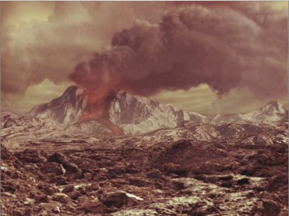
Another volcanoes are: Anala Mons is a volcano, located in a region called the Sappho Patera quadrangle where numerous other volcanic features can be found. Theia Mons is a large shield volcano . Sacajawea Caldera. Venus is known to be covered with volcanoes, but are any of these active? Results from Venus Express, using VIRTIS data (See the article on New evidence for recent volcanism on Venus) indicates that a number of lava flows on Venus are very young, and that most likely the planet is currently volcanically active- http://sci.esa.int/science-e/www/object/index.cfm?fobjectid=46814. время от времени вулканы на Венере просыпаются и в нашу эпоху, но пока не поймали ни одного работающего, хотя косвенные признаки (вроде колебаний в составе атмосферы и молний) космические аппараты уже находили. В далёком прошлом, однако, вулканизм здесь был самым мощным во всей Солнечной системе (иллюстрация ESA, AOES Medialab).http://www.membrana.ru/particle/13927 |
Абсолютно сухие каменистые долины и древние вулканы, вершины гор, покрытые (гипотетически) металлической изморозью. |
Beta Regio is a region known as a volcanic rise. Measuring about 3000 km, it constitutes a prominent upland region of Venus centered at 25o18’N 282o48’E25.3oN 282.8oE. Volcanic rises are broad, sloping highlands over 1000 km across. They are cut by deep troughs 100–200 km across. These troughs are an example of continental rifting, and are evidence of surface tectonism -http://en.wikipedia.org/wiki/Beta_Regio http://nssdc.gsfc.nasa.gov/imgcat/html/object_page/mgn_c314n300_1.html |
The 37-km-diameter crater Somerville in Beta Regio, which has been rifted by Devana Chasma-http://www.lpi.usra.edu/science/kiefer/Publications/magellan-txt.html |
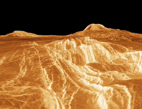
A perspective view of the Guor Linea rift zone in Eistla Regio. The shield volcanos Gula Mons and Sif Mons are in the background. NASA image-http://www.lpi.usra.edu/science/kiefer/Publications/magellan-txt.html |
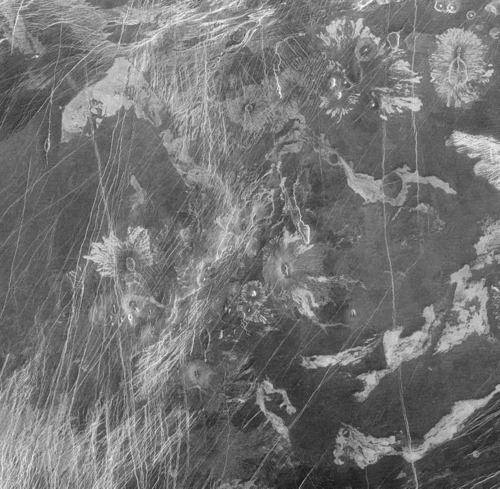
Volcano in Parga Chasma - http://photojournal.jpl.nasa.gov/catalog/PIA00243 |
Volcanic features in Atla Region - http://photojournal.jpl.nasa.gov/catalog/PIA00201 |
Ishtar Terra is one of two main highland regions on the planet Venus. It is the smaller of the two "continents", and is located near the north pole. Ishtar Terra also contains volcanoes named after famous women: Sacajawea, Colette, and Cleopatra. Ishtar Terra is also the site of much tessera, which might provide evidence that the planet''s surface is in motion - http://en.wikipedia.org/wiki/Ishtar_Terra |
Aphrodite Terra has two main regions: Ovda Regio in the west and Thetis Regio in the east - http://en.wikipedia.org/wiki/Aphrodite_Terra |
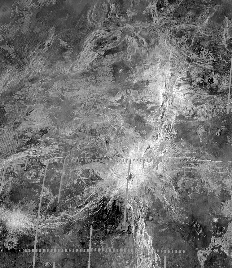
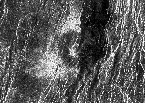
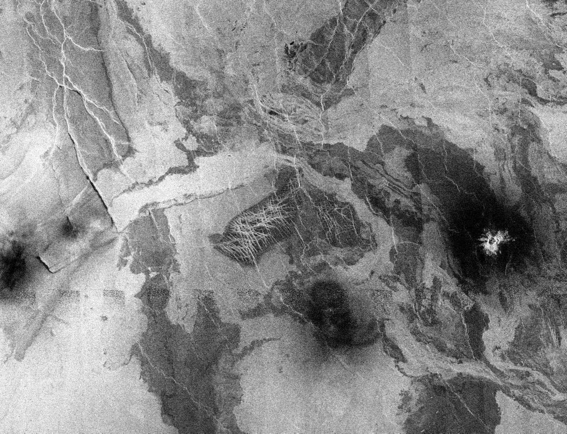
Один из наборов параллельных горных цепей, послуживший отправной точкой в вычислениях Вики Хансен. Это компьютерное изображение, синтезированное по данным измерений радара Magellan (иллюстрация NASA/JPL). |
Maxwell Montes. The origin of the Lakshmi Planum and the mountain belts such as Maxwell Montes is controversial. One theory suggests they formed over a hot plume of material rising from the interior of the planet, while another says the region is being compressed (pushed together) from all sides, resulting in material descending into the interior of the planet. The broad ridges and valleys making up Maxwell Montes and Fortuna Tessera suggest that the topography resulted from compression. The parallel ridges and valleys were cut by later extensional faults. The extreme height of Maxwell Montes in relation to other compressional mountain ranges around Lakshmi Planum suggests that its origin is more complex-http://en.wikipedia.org/wiki/Maxwell_Montes. Lakshmi Planum and the western edge of Maxwell Montes. The plains of Lakshmi are made up of radar-dark, homogeneous, smooth lava flows. Located near the center of the image is a feature previously mapped as tessera made up of intersecting 1- to 2-km (0.6 to 1.2 miles) wide graven. The abrupt termination of dark plains against this feature indicates that it has been partially covered by lava. Additional blocks of tessera are located along the left hand edge of the image. A series of linear parallel troughs are located along the southern edge of the image. These features, 60- to 120-km (36- to 72- miles) long and 10- to 40- km (6- to 24- miles) wide are interpreted as graben. Located along the right hand part of the image is Maxwell Montes, the highest mountain on the planet, rising to an elevation of 11.5 km (7 miles) and is part of a series of mountain belts surrounding Lakshmi Planum - http://photojournal.jpl.nasa.gov/catalog/PIA00241 |
Lakshmi Planum is ringed by intensely deformed terrain, some of which is shown in the southern portion of the image and is called Clotho Tessera. The 64-kilometer (40 mile) diameter circular feature in the image is a depression called Siddons and may be a volcanic caldera. This view is supported by the collapsed lava tubes surrounding the feature. By carefully studying this and other surrounding images scientists hope to discover what tectonic and volcanic processes formed this complex region. The solid black parts of the image represent data gaps that may be filled in by the Magellan extended missio- http://photojournal.jpl.nasa.gov/catalog/PIA00240 |
Alpha Regio is a region of the planet Venus extending for about 1500 kilometers centered at 22oS, 5oE.The surface of the region is what is known as Tessera, meaning a terrain that has been highly deformed and where the deformation strikes in multiple directions and is closely spaced.On Earth, such light-coloured rocks are usually granite and form continents- http://en.wikipedia.org/wiki/Alpha_Regio |
Alpha Regio. Seven circular, dome-like hills, averaging 25 kilometers (15 miles) in diameter with maximum heights of 750 meters (2,475 feet) dominate the scene. These features are interpreted as very thick lava flows that came from an opening on the relatively level ground, which allowed the lava to flow in an even pattern outward from the opening. The complex fractures on top of the domes suggest that if the domes were created by lava flows, a cooled outer layer formed and then further lava flowing in the interior stretched the surface. The domes may be similar to volcanic domes on Earth. Another interpretation is that the domes are the result of molten rock or magma in the interior that pushed the surface layer upward. The near-surface magma then withdrew to deeper levels, causing the collapse and fracturing of the dome surface. The bright margins possibly indicate the presence of rock debris on the slopes of the domes. Some of the fractures on the plains cut through the domes, while others appear to be covered by the domes. This indicates that active processes pre date and post date the dome-like hills- http://photojournal.jpl.nasa.gov/catalog/PIA00215 |
This Magellan image shows part of the northern boundary of Ovda Regio, one of the large highlands ringing the equator of Venus. The scene consists largely of low-relief, rounded linear ridges. These ridges, 8-15 kilometers in width and 30-60 kilometers long, lie mostly along a 100-200 kilometer wide slope where the elevation drops 3 kilometers from Ovda Regio to the surrounding plains. Some of the ridges have been cut at right angles by extension fractures. Dark material, either lava or windblown dirt, fills the region between the ridges. The curvilinear, banded nature of these ridges suggests that crustal shortening, roughly oriented north-south, is largely responsible for their formation. Such crustal shortening was unexpected by Magellan scientists, who believed that Ovda Region, a likely site of hot upwelling from the interior of Venus, should be dominated by volcanism and crustal extension. This image, centered approximately at 1 degree north, 81 degrees east, measures 300 kilometers by 225 kilometers- http://photojournal.jpl.nasa.gov/catalog/PIA00242 |
Asteria Regio and Phoebe Regio - a geographically young region of lowland plains. The location is near the equator between two highland areas known as Asteria Regio and Phoebe Regio. Complex canyon systems that trend northeast and northwest were produced as Venus'' crust was pulled apart by extensional forces. Some were filled with younger lava flows. The canyons are typically 5 to 10 km (3 to 6 miles) wide, 50 to 100 km (30 to 60 miles) long and rimmed by fault scarps a hundred meters or so high.- http://photojournal.jpl.nasa.gov/catalog/PIA00237 |
The eastern Lakshmi region of Venus.The image shows a relatively flat plains region composed of many lava flows. The dark flows mostly likely represent smooth lava flows similar to ''pahoehoe'' flows on Earth while the brighter lava flows are rougher flows similar to ''aa'' flows on Earth. (The terms ''pahoehoe'' and ''aa'' refer to textures of lava with pahoehoe a smooth or ropey surface, and aa a rough, clinkery texture)- http://photojournal.jpl.nasa.gov/catalog/PIA00082 |
Lineated Plains in Lakshmi Region , this region is located on the low rise that separates Sedna Planitia and Guinevere Planitia, just to the west of Eistla Regio.Two sets of parallel lineations are seen intersecting almost at right angles. The fainter lineations are spaced at regular intervals of about one kilometer (0.6 mile) and extend beyond the boundary of the image. The width of the faint lineations is at the limit of resolution of the best Magellan images. The brighter, more dominant lineations are less regular and, in places, appear to begin and end where they intersect the fainter lineations. It is not clear whether the two sets of lineations are faults or fractures, but in other Magellan images, these bright lineations are associated with pit craters and volcanic features- http://photojournal.jpl.nasa.gov/catalog/PIA00085 |
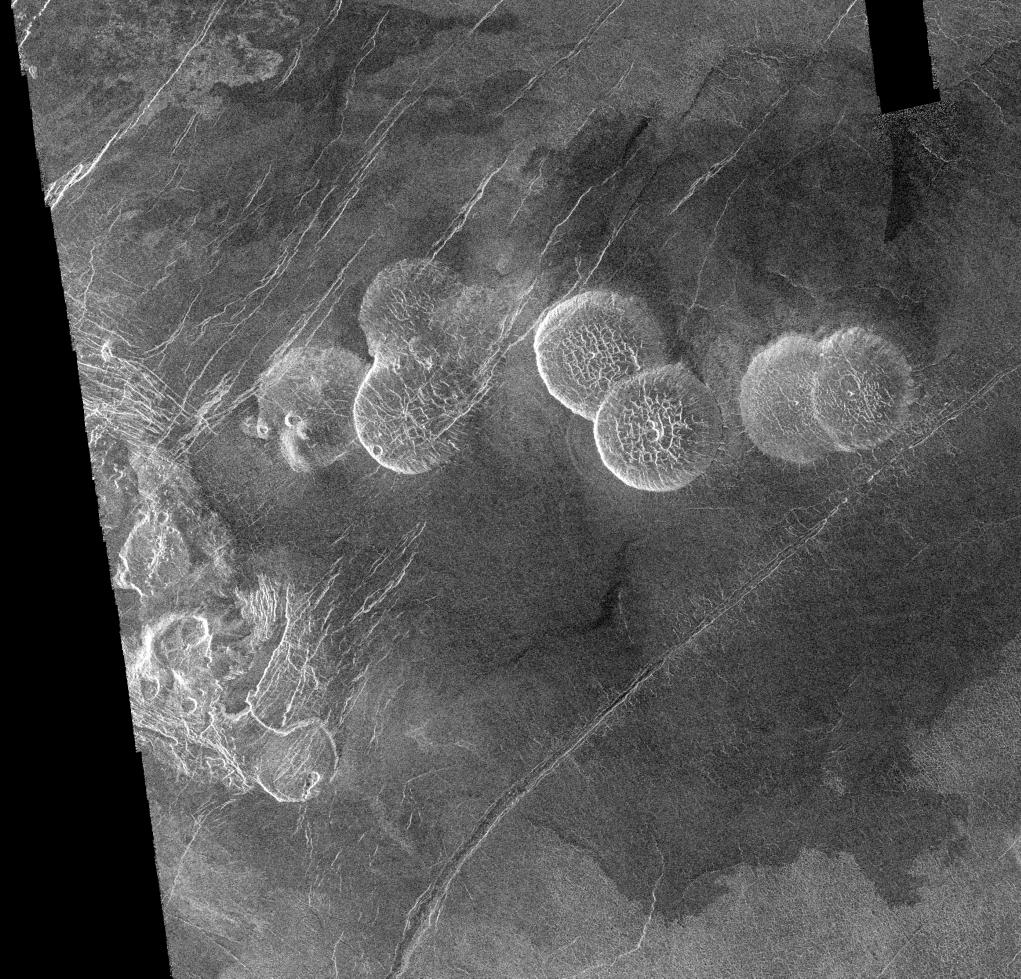
the Eistla region of Venus. The prominent circular features are volcanic domes, 65 kilometers (39 miles) in diameter with broad, flat tops less than one kilometer (0.6 mile) in height. Sometimes referred to as ''pancake'' domes, they represent a unique category of volcanic extrusions on Venus formed from viscous (sticky) lava. The cracks and pits commonly found in these features result from cooling and the withdrawal of lava. A less viscous flow was emitted from the northeastern dome toward the other large dome in the southwest corner of the image- http://photojournal.jpl.nasa.gov/catalog/PIA00084 |
Lavinia Region Ridge Belts, Plains and Lava Flows - http://photojournal.jpl.nasa.gov/catalog/PIA00087 |
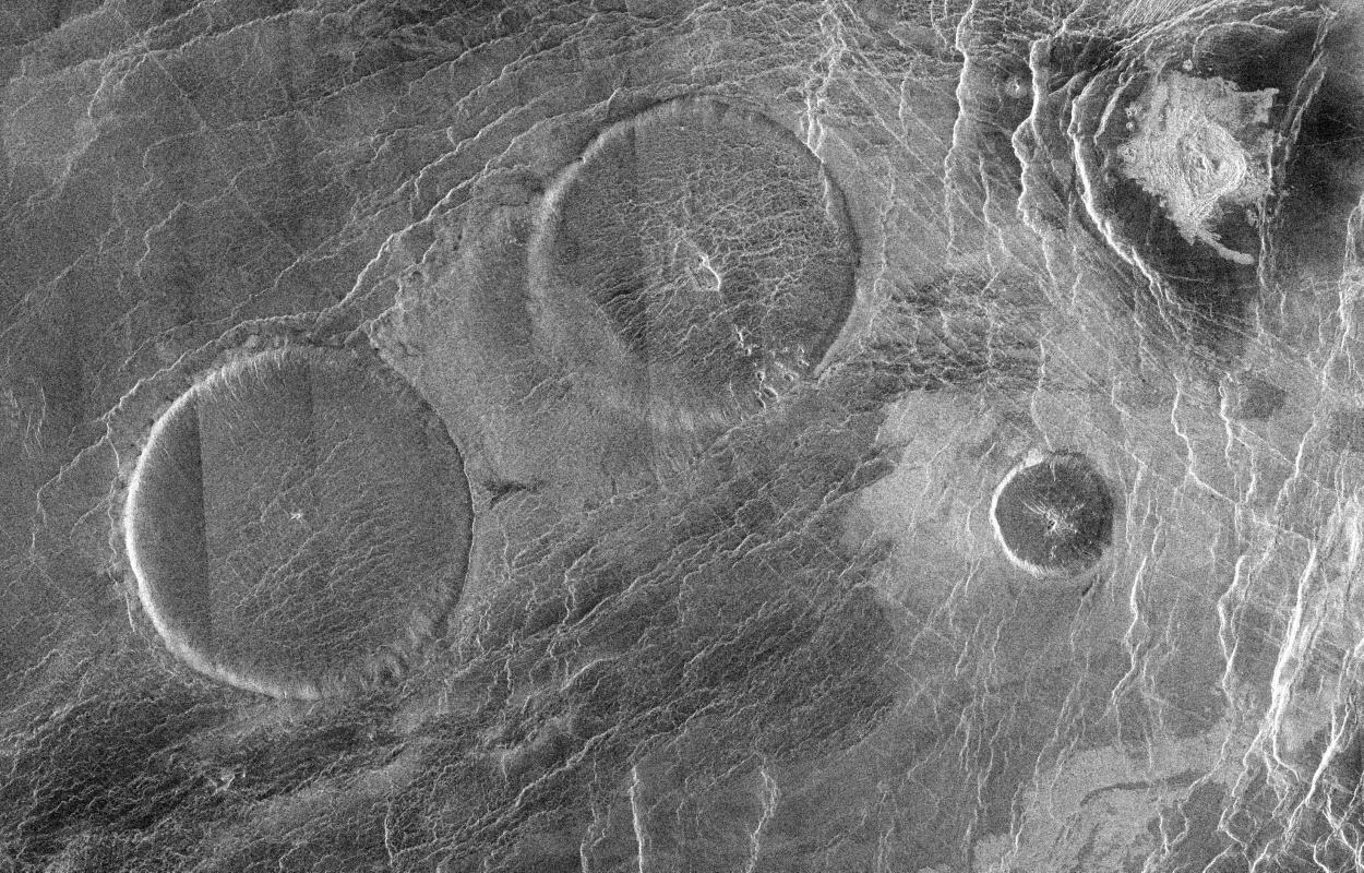
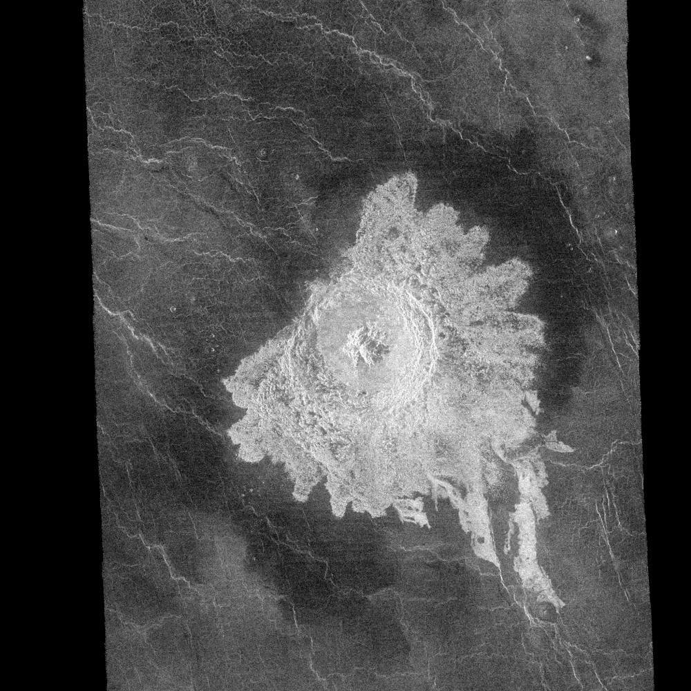
Crater Aurelia - a complex crater - http://photojournal.jpl.nasa.gov/catalog/PIA00239 |
Eistla Regio -http://photojournal.jpl.nasa.gov/targetFamily/venus?start=100 |
Кратеры Данилова, Aglaonice и Saskja. Impact craters from radar http://en.wikipedia.org/wiki/Venus#Geography |
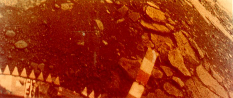
Venera 13 - the first color photographs of the surface |
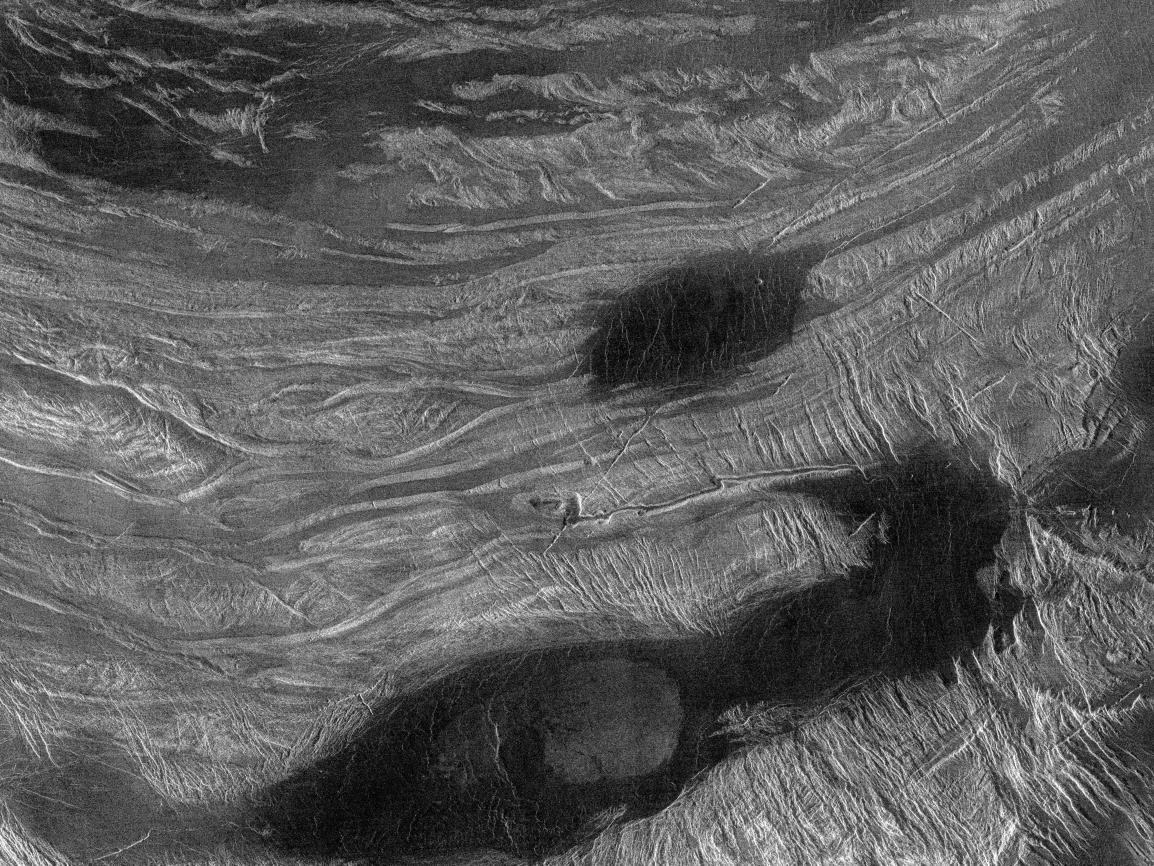
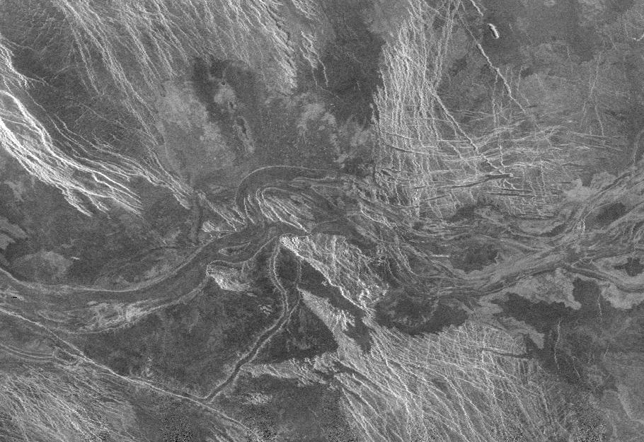
the Lada Terra region of Venus. Numerous streamlined structures within the channel attest to the very high temperature, very fluid lavas (resulting in both thermal and mechanical erosion) responsible for carving the channel-http://photojournal.jpl.nasa.gov/catalog/PIA00219 |
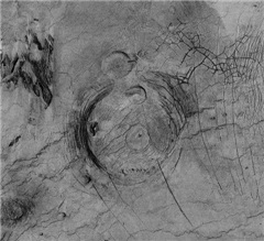
Fotla Corona |
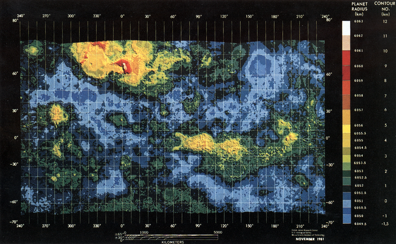
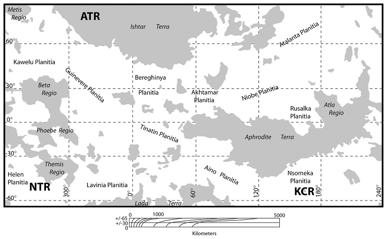
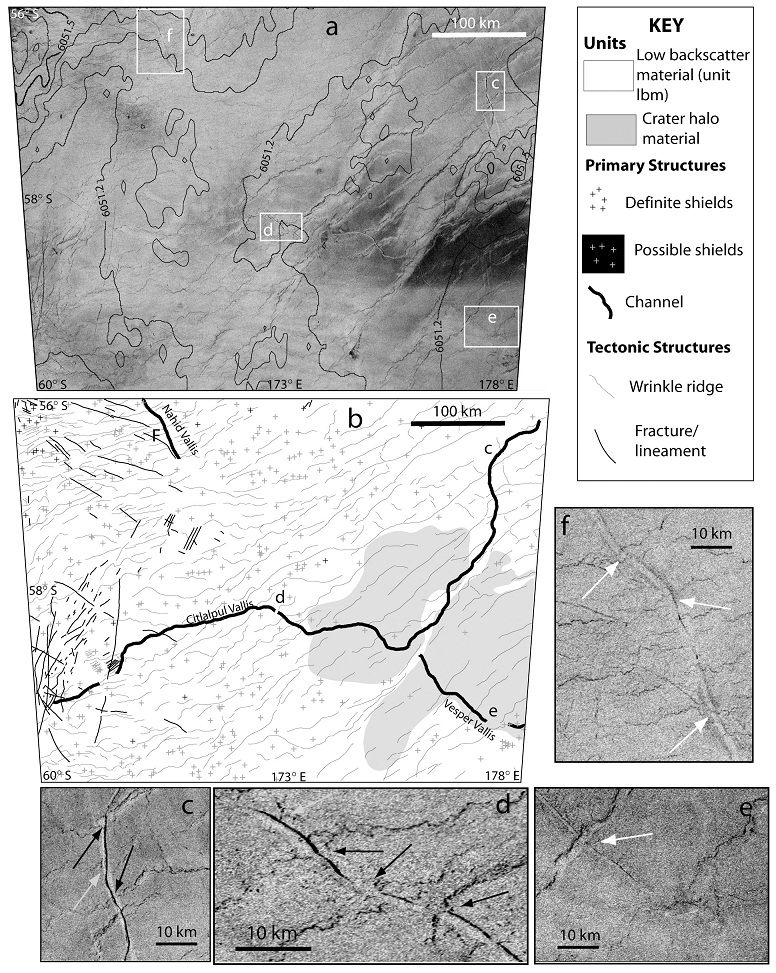
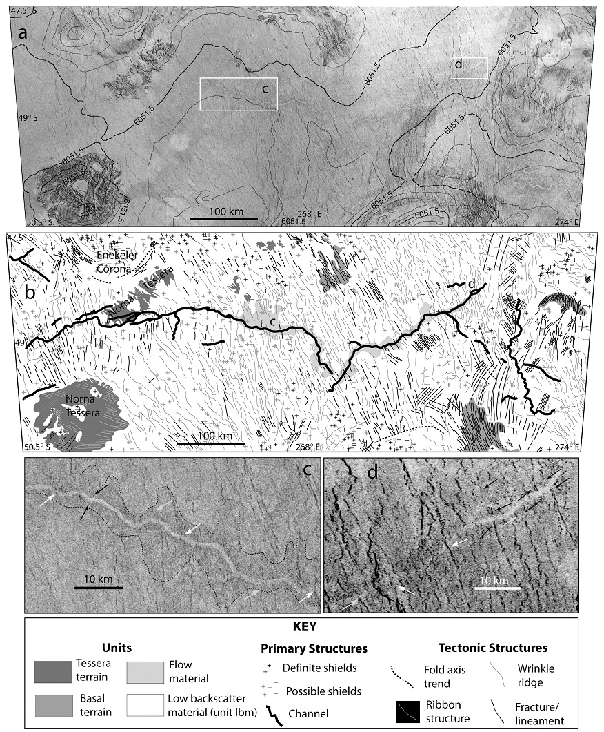
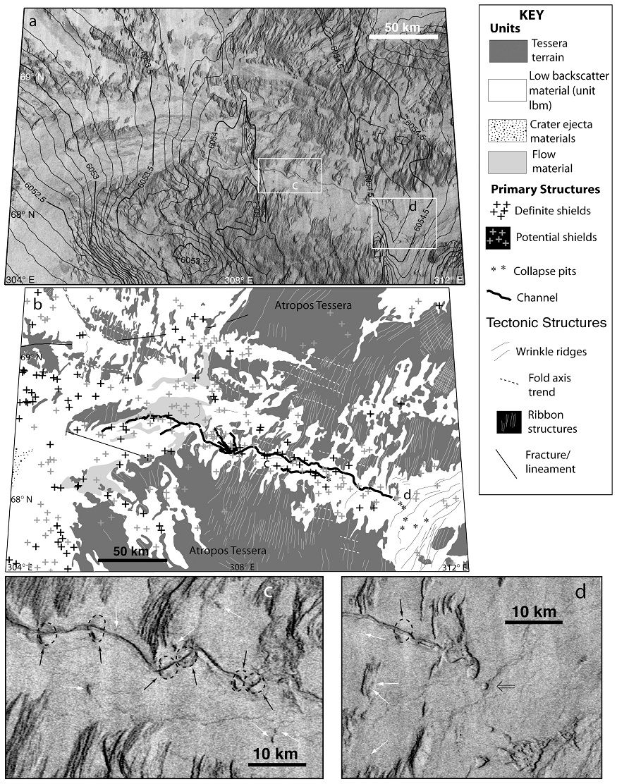
Sketch map of Venus in Mercator Projection showing the locations of the three field sites studied in this paper: (1) Norna Tessera region (NTR: 49_S, 268_E), (2) Kahlo Crater region (KCR: 58_S, 173_E), and (3) Atropos Tessera region (ATR: 68.5_N, 308_E). Gray regions represent highlands. After Guest et al. [1992]. |
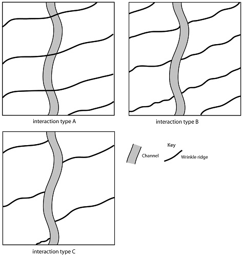
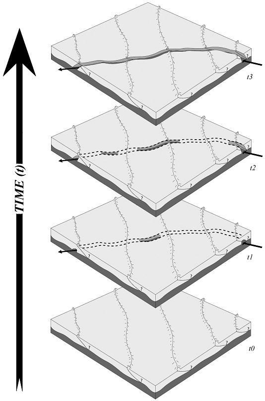
VENUSIAN CHANNEL FORMATION. Cartoon maps illustrating the three types of channel-wrinkle ridge interactions noted in the KCR field site. Interaction type A: Wrinkle ridges occur up to, through, and across the channel as complete entities; there is no interruption in the continuity of the ridges by the channel and the channel is ultimately deformed by the ridge. An imprint of the channel can be observed in cases where the wrinkle ridge is wide enough (see Figure 2e). Interaction type B: Wrinkle ridges end at the margin of the channel and then continue with the same trend on the opposite side of the channel margin such that the ridges appear that they should connect across the channel; ridges are absent within the channel. The course of the channel is not influenced, impeded, or deflected by the presence of the ridges. Interaction type C: Wrinkle ridges end at the channel margin and do not continue on the opposite side of the channel margin; ridges are absent within the channel. The course of the channel is not influenced, impeded, or deflected by the presence of the ridges - http://math.mercyhurst.edu/~nlang/assets/publications/Lang_Hansen_2006.pdf . |
Inverted synthetic aperture radar (SAR) image of the Kahlo Crater region shown with contoured altimetry data (contour interval is 100 m), white boxes surrounding c, d, e, and f show the locations of the c, d, e, and f insets: (b) Geologic map and (c–f) enlarged SAR images highlighting the three channel-wrinkle ridge relationships. White arrows highlight interaction type A - http://math.mercyhurst.edu/~nlang/assets/publications/Lang_Hansen_2006.pdf |
a-Inverted SAR image of the Norna Tessera region shown with contoured altimetry data (contour interval is 100 m), white boxes surrounding c and d show the locations of the c and d insets; (b) geologic map, and (c,d) enlarged SAR images highlighting the three channel-wrinkle ridge relationships. White arrows highlight interaction type A, black arrows highlight interaction type B, and gray arrows highlight interaction type C. Dashed lines in c represent the outline boundaries of high backscatter material that occurs along two segments of Sinann Vallis - http://math.mercyhurst.edu/~nlang/assets/publications/Lang_Hansen_2006.pdf . |
(a) Inverted SAR image of the Atropos Tessera region shown with contoured altimetry data (contour interval is 100 m), white boxes surrounding c and d show the locations of the c and d insets; (b) geologic map; (c, d) enlarged SAR images highlighting the channel-shield relationships observed in ATR. Black arrows highlight the locations of the erosional remnants of shield edifices and dashed black circles represent the outlines of reconstructed shield edifices; white arrows highlight intact shield edifices; double-barred arrow in d highlights flow material that surrounds a pit near the beginning of Lunang Vallis- http://math.mercyhurst.edu/~nlang/assets/publications/Lang_Hansen_2006.pdf -. |
|
Это компьютерная анимация, изображающая возможный вид одного из районов Венеры во время грозы. Данные о молниях были получены с помощью магнитометра, установленного на Venus Express (анимация ESA/C. Carreau). http://www.membrana.ru/particle/12143 |
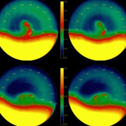
Ветры на Венере обращаются на запад, на скорости в сотни километров в час, и обегают планету всего за четыре дня. Это «супервращение», объединённое с естественной рециркуляцией горячего «воздуха» в атмосфере планеты, должно, по идее, создавать по огромному вихрю на каждом из полюсов. И они там есть.Двуглазый вихрь на южном полюсе Венеры глазами Venus Express (цвета — искусственные) (фото ESA/VIRTIS/INAF-IASF/Obs. de Paris-LESIA)-http://www.membrana.ru/particle/10193 |
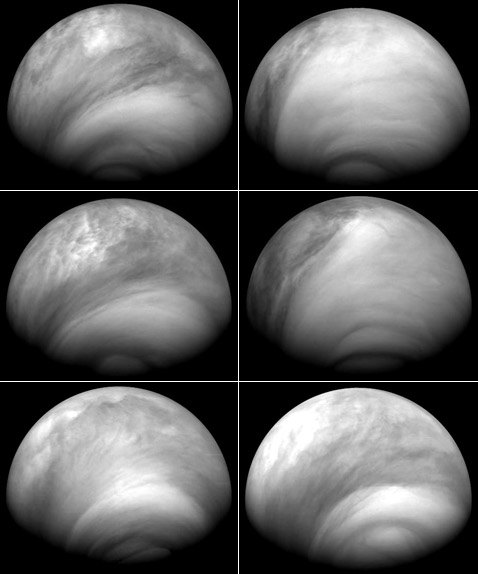
Серия снимков южного полушария Венеры в ультрафиолете показывает крупномасштабные перемены в концентрации и расположении сернокислотного тумана. Кадры сделаны Venus Express 23, 24, 27, 28, 30 июля и 4 августа 2007-го (фотографии ESA/MPS/DLR/IDA)- http://www.membrana.ru/particle/12333. Средняя температура венерианской атмосферы +462° по Цельсию, а её давление у поверхности в 90 раз больше, чем на Землe. Как и современная Земля, Венера некогда была покрыта океанами, — утверждают астрономы. Но теперь там вода содержится лишь в атмосфере и в густых облаках серной кислоты, окутывающей планету. Есть подозрение, что некогда венерианские океаны «выкипели» из-за парникового эффекта. Подтверждением тому служит высокое содержание типичного для такого явления углекислого газа, доля которого среди компонентов атмосферы составляет 96,5%, ионы кислорода, гелия и водорода покидают атмосферу. Kислород и водород обнаружились в такой же пропорции, в какой они составляют молекулы воды. Другое подтверждение наличия воды получено благодаря анализу уровня дейтерия — «тяжёлого» водорода. Oбычный водород, «оставшийся» после распада молекул воды, быстрее покидает атмосферу, чем «тяжёлый» -по содержанию «остатков» дейтерия можно судить о том, сколько воды было раньше, жидкости некогда было достаточно, чтобы покрыть Венеру четырёхметровым слоем, что соответствует объёму океанов Земли. Этот фактор указывает на то, что миллиарды лет назад Венера и Земля были близнецы, которых разлучили вскоре после рождения и которые стали в дальнейшем развиваться по-разному - http://www.membrana.ru/particle/12143 |
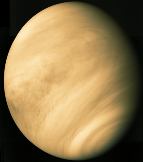
Снимок Венеры с борта межпланетной станции Mariner 10 (фото Calvin J.Hamilton/NASA/ESA).Плотные многокилометровые облака из серной кислоты в смеси с соединениями хлора и фтора, делающие планету при взгляде снаружи — блистающей, а при взгляде наблюдателя с её поверхности – сумеречной. |
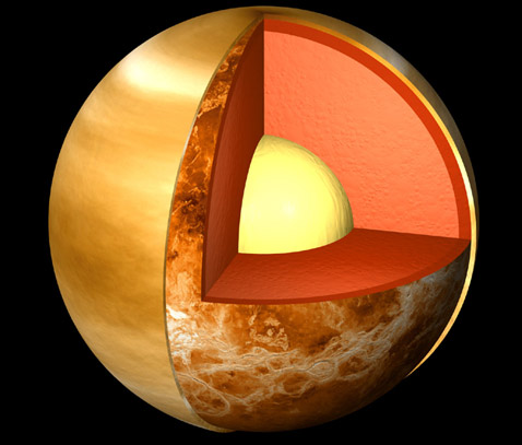

Состав ядер Венеры и Земли схож. Венера имеет небольшое магнитное поле, так что ее внутренняя динамика все же отлична от земной. Мантийная конвекция имеется, но процессы тектоники плит не представлены в топографии Венеры. Тектоническая деятельность на планете, похоже, ограничена резкими выбросами плюмов и процессами опускания (downwelling) материала в недра планеты, а не процессами бокового движения и субдукции.
Радары Магеллана установили базальтовый вулканизм и тектонические деформации как доминирующие процессы на планете при низкой плотности ударных кратеров.
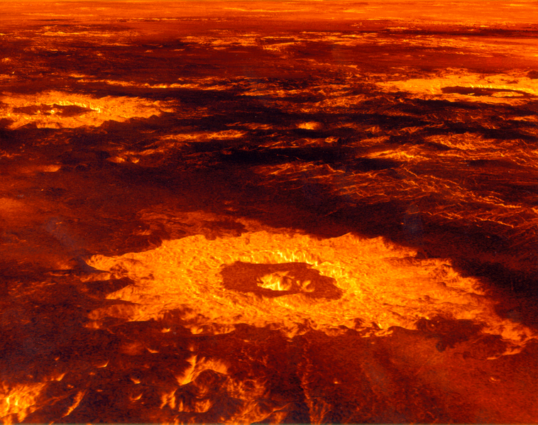
Приблизительно 80 % поверхности Венеры состоит из равнин, закрытых вулканическим потоком. Некоторые лавовые каналы тянутся на сотни км, одна извилина достигла даже 6800 км. Идентифицированы тысячи вулканических структур, большинство из них представлено маленькими щитовидными вулканами, однако более 1500 вулканов имеют величину более чем 20 км. Sapas Mons имеет 400 км в поперечнике и высоту в 1,5 км. От флангов этого вулкана отходят вторичные потоки на манер вулканов Гавайского типа. Только 8 % поверхности Венеры состоят из горной местности, которую можно бы было уподобить континентальным областям Земли.
Когда получили возможность составить точную карту Венеры, были удивлены малым числом крупных ударных кратеров — их оказалось примерно 1 тысяча. Ожидалось же 5 тысяч — исходя из аналогичных показателей других планет и существующих представлений о раннем этапе жизни Солнечной системы, когда все планеты подвергались мощной астероидной и кометной бомбардировке. Тогда был сделан вывод о молодости поверхности Венеры. Ведь даже те немногочисленные кратеры, что учёные там нашли, на удивление хорошо сохранились, примерно 500 MA планета пережила краткий период очень мощного вулканизма, и слой лавы толщиной от 1 до 3 км укрыл следы древней поверхности.
Aппарат Magellan заставил пересмотреть это представление, изучили участки поверхности, где на плоских равнинах возвышаются рельефные детали ландшафта — цепочки параллельных горных хребтов. Исследовав склоны, идущие вниз и «исчезающие» на равнине (предположительно, поверхности бывшей лавы), вычислили положение точек, где эти склоны соединяются — внизу, под поверхностью.
Оказалось, что эти точки, показывающие расположение некой основы наблюдаемого горного рельефа, лежат менее чем в 1 километре под поверхностью, что противоречит гипотезе катастрофического вулканизма, согласно которой толщина слоя должна быть втрое больше.
Взамен одной вулканической катастрофы предлагают картину длинного ряда всплесков вулканизма, следовавших на протяжении значительной доли существования планеты. При этом большая часть древней поверхности Венеры осталась видна до сих пор.
Эта гипотеза согласуется с выводами группы Timothy Bond и Michael Warner, Imperial College London.
Они установили, что постепенное снижение интенсивности вулканической деятельности на протяжении 2000 MA соответствует статистике кратеров Венеры.
Таким образом, группа Вики Хансен утверждает, что возраст большей части поверхности Венеры — свыше 1000 MA (from http://www.membrana.ru/particle/10792).
B прошлом Венера разделяла с Землёй ряд важных особенностей (данные спутникa Venus Express): наличие отдельных материков и водных океанов между ними, а ещё тектонику плит. Тысячи отдельных инфракрасных снимков 2006 и 2007 г. собраны в карту южного полушария Венеры. «Это ещё не доказательство, но последовательность свидетельств, — говорит один из исследователей Nils Muller, Universitat Munster. — Всё, что мы можем уверенно сказать сейчас: отдельные плато выглядят по-другому в сравнении с соседями».
Речь идёт об областях Альфа и Феба. Спутник делал снимки ночной стороны Венеры при помощи спектрометра VIRTIS. И на его кадрах данные регионы смотрятся светлее и старше других районов планеты.
Яркость поверхности в ИК-диапазоне зависит от температуры, а ещё от состава пород (влияет на теплоотдачу). Однако разница в температуре разных участков полушария нигде не превышает 20 градусов. Это скорее свидетельствует об отсутствии лавовых потоков и, следовательно, вулканической активности в данный момент времени - лава давала бы больший температурный контраст.
Потому отличие в инфракрасном изображении двух плато от всех остальных обусловлено их составом. На Земле аналогичную разницу покажет гранит, составляющий континентальную кору. «Если на Венере есть гранит, то в прошлом там должны были быть океаны и тектоника плит», — говорит Мюллер. Тектоника плит Венеры, в свою очередь, может объяснить её давнюю очень высокую вулканическую активность. Правда, доказать наличие гранита можно, только отправив спускаемые аппараты. Предыдущие венерианские зонды находили только базальтовые породы - http://www.membrana.ru/particle/13927.