 | NCVP and Anahim Volcanic Belt |
http://volcano.oregonstate.edu/vwdocs/volc_images/north_america/canada/Canada.html |
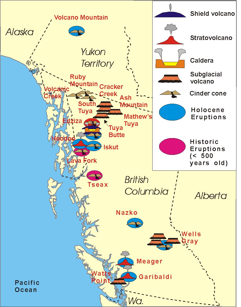
Northern Cordilleran Volcanic Province.Lava Fork Volcano. The Volcano, also known as Lava Fork volcano, is a small cinder cone in the Boundary Ranges of the Coast Mountains. It is located near the head of Lava Fork. With a summit elevation of 1,330 m, it rises above the surrounding rugged landscape on a remote mountain ridge that represents the northern flank of a glaciated U-shaped valley. Lava Fork volcano is associated with a small group of related volcanoes called the Iskut-Unuk River Cones. Eruptive activity at The Volcano is relatively young compared to most other volcanoes in the Northern Cordilleran Volcanic Province. Geologic studies have shown that The Volcano and its eruptive products were emplaced in the past 400 years; this is well after the last glacial period, which ended about 10 KA.Like most cinder cones, The Volcano consists of a pile of loose volcanic ash, lapilli-sized tephra and volcanic bombs. These were deposited during periods of lava fountain activity. The vent area contains volcanic bombs up to 0.5 m long and small deposits of sulfur precipitated from volcanic gases. The Volcano being one of the three having erupted in the last few hundred years - http://en.wikipedia.org/wiki/The_Volcano_(British_Columbia) |
Northern Cordilleran Volcanic Province.The Volcano is the southernmost of 10 volcanoes comprising the Iskut-Unuk River Cones volcanic field, as well as the most recent to erupt. Its structure is poorly formed and has been reduced by erosion from alpine glacial ice found at its elevation and latitude. It represents one of the few historically active volcanoes in the NCVP with a base elevation estimated to be 100 m.Cones volcanic fild. Iskut Canyon Cone, also known as Iskut River Cone, is a cinder cone of the Iskut-Unuk River Cones group in northwestern British Columbia, Canada, located on the steep southern flank of the Iskut valley near its junction with Forrest Kerr Creek. It last erupted during the Holocene epoch. Cinder Mountain, 300m, Boundary Ranges is a partly eroded cinder cone at the head of Snippaker Creek, British Columbia, Canada. It is one of the Iskut-Unuk River Cones and is the source of a basaltic lava flow that extends 4 km (2 mi) north into Copper King Creek. An isolated pile of subaerial basalt flows and associated pillow lava rest on varved clay and till in King Creek. Cinder Mountain last erupted during the Pleistocene. Cone Glacier Volcano is a cinder cone in the Boundary Ranges of the Coast Mountains in northwestern British Columbia, Canada. It is part of the Iskut-Unuk River Cones group and last erupted during the Holocene period.[1] Cone Glacier contains two arms that surround the volcano. King Creek Cone is a subglacial mound of the Iskut-Unuk River Cones group in northwestern British Columbia, Canada. It last erupted during the Pleistocene epoch. Seconed Canyon Cone 300 m , also called Canyon Creek Cone is a cinder cone in the Boundary Ranges of the Coast Mountains in northwestern British Columbia, Canada. It is a volcanic feature of the Iskut-Unuk River Cones which is part of the Northern Cordilleran Volcanic Province and formed in the past 10,000 years of the Holocene epoch. Snippaker Creek Cone is a cinder cone of the Iskut-Unuk River Cones group in northwestern British Columbia, Canada, located near the western flank of Cinder Mountain. It last erupted during the Holocene epoch. Tom MacKay Creek Cone is a subglacial mound in northwestern British Columbia, Canada. It is part of the Iskut-Unuk River Cones group and last erupted during the Pleistocene epoch |
A photo of The Volcano with thick black scoria in the foreground -http://en.wikipedia.org/wiki/The_Volcano_(British_Columbia). At least two phases of volcanic activity have been identified at The Volcano. Each event was followed by the eruption of lengthy basaltic lava flows that flowed down steep granitic flanks of the mountain ridge on which The Volcano lies. After this took place, they travelled through the Lava Fork valley for 5 km. Here, the flows crossed the British Columbia border into the U.S. state of Alaska and blocked the Blue River, a tributary of the Unuk River, forming several lakes. The lava flows in total are about 22 km long and still contain their original features from when they cooled, including pressure ridges and lava channels. A series of large trees were engulfed by the lava flows during eruption. The bases of the trees burned and the upper trunks and branches collapsed into the solidifing lava, leaving the trees embedded on the surface of the lava flows. After the flows solidified, tree molds and lava tubes collapsed to form volcanic pits. At the southern end of one of the lava flows, it spreads into a broad terminal lobe on the flat alluvial plain of the Unuk River. Volcanic ash and lava from The Volcano still linger on small glaciers near Mount Lewis Cass, a 2,094 m high mountain near the Alaska-British Columbia border. At least one lava flow from The Volcano was notified by a surveyor named Fremont Morse in 1905. Tree ring and radiocarbon dating techniques have been used to establish the dates of The Volcano''s two volcanic phases. The first is estimated to have occurred about 360 years ago and the latest possibly took place only 150 years ago. This indicates that The Volcano is the youngest known volcanic mountain in Canada and that its volcanic activity is recent compared to many other volcanoes in British Columbia. In several documents, the last eruption of The Volcano is written to have occurred in 1904. At least two phases of volcanic activity have been identified at The Volcano. Each event was followed by the eruption of lengthy basaltic lava flows that flowed down steep granitic flanks of the mountain ridge on which The Volcano lies. After this took place, they travelled through the Lava Fork valley for 5 km. The lava flows in total are about 22 km long and still contain their original features from when they cooled, including pressure ridges and lava channels. A series of large trees were engulfed by the lava flows during eruption. The bases of the trees burned and the upper trunks and branches collapsed into the solidifing lava, leaving the trees embedded on the surface of the lava flows. After the flows solidified, tree molds and lava tubes collapsed to form volcanic pits. At the southern end of one of the lava flows, it spreads into a broad terminal lobe on the flat alluvial plain of the Unuk River. Volcanic ash and lava from The Volcano still linger on small glaciers near Mount Lewis Cass, a 2,094 m high mountain near the Alaska-British Columbia border. Although The Volcano is estimated to have last erupted 150 years ago, it is one of the five volcanoes in the Northern Cordilleran Volcanic Province that have recorded seismicity since 1985. -http://en.wikipedia.org/wiki/The_Volcano_(British_Columbia) |
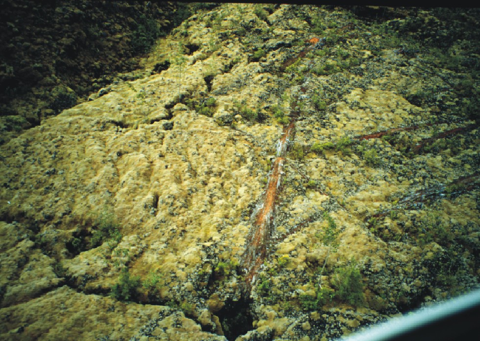
Recently erupted pahoehoe lava flow in the Iskut-Unuk River. Cones volcanic field.A recently erupted pahoehoe lava flow extending down the vegetated flanks of a mountain ridge. The alpine lake in the upper left corner is the southern lake of the two Lava Lakes - http://en.wikipedia.org/wiki/Volcanic_history_of_the_Northern_Cordilleran_Volcanic_Province |
Lava flows erupted from The Volcano. Trees were engulfed near the distal end of these lava flows -http://en.wikipedia.org/wiki/The_Volcano_(British_Columbia). At least seven eruptions have occurred in the Iskut-Unuk River volcanic field in the past 10 KA. Since around 1600 all eruptions have occurred at The Volcano. Its total eruption volume is estimated to be 2.2 km3. Future eruptions from The Volcano will probably be similar in character to those that have occurred throughout its 360-year eruptive history. There is a one in 200 chance per year of an eruption occurring in Canada and one in 220 chance per year of an effusive eruption. An eruption in the foreseeable future is probably more likely along the NCVP than in an unrelated volcanic zone outside the province. This is because the Northern Cordilleran Volcanic Province, which includes the Iskut-Unuk River Cones, is the most active volcanic zone in Canada. A small range of effects are expected from future eruptions at The Volcano. Its remote uninhabited location makes volcanic hazards less extreme and is therefore not very hazardous. Ash and rock fragments (tephra) ejected during lava fountain activity are unlikely to be high enough to disrupt regional air traffic. However, they could possibly endanger lower flying aircraft along the northern coastal corridor between Vancouver and Alaska. The closest major air route is about 170 km to the east. Volcanic ash reduces visibility and can cause jet engine failure, as well as damage to other aircraft systems.Lava flows emitted during future volcanic eruptions would likely be basaltic in nature based on the composition of its lavas produced during past volcanic activity. Basaltic lava flows are low in silica content and can have speeds extending from 15 to 50 km/h (10 to 30 mph). The last eruption at The Volcano 150 years ago had a large impact on fish, plant and animal inhabitants in the valley the lava flows travelled through to cross the Canada � United States border. Because of these circumstances, future eruptions may again block the flow of local water courses if the volume of the erupted lavas are significant enough. This would again have disastrous consequences for fish habitats and spawning grounds. However, there are neither records of any impacts on people during this eruption, nor evidence that it was even witnessed by people. A repeat of wildfires in the Lava Fork valley is also a possibility due to the existence of vegetation on and around the erupted lavas - http://en.wikipedia.org/wiki/The_Volcano_(British_Columbia). |
The surface of the lava flows still have well-preserved flow features (pressure ridges and lava channels), pits formed when the overlying solidified lava collapsed into underlying lava tubes, and tree molds (seen in the picture above). Also seen in the picture above, locally large trees are embedded in the top of the lava flows. Based on dating of tree-ring cores and radiometric ages from 14C dating, the youngest of these lava flows is probably only 150 years old (Hauksdottir et al., 1994) - http://volcano.oregonstate.edu/vwdocs/volc_images/north_america/canada/Final-LF.html http://en.wikipedia.org/wiki/Volcanic_history_of_the_Northern_Cordilleran_Volcanic_Province |
Iskut-Unuk River Cones volcanic field. The valley-filling lava flows (shown above) traveled south 5 km where they crossed the border into Alaska and dammed the Blue River, forming several small lakes. In total the lava flows are approximately 22 km long. Like other Iskut-Unuk River Cones, The Volcano has its origins in continental rifting�a long rupture in the Earth''s crust where the lithosphere is being pulled apart. This incipient rifting has formed as a result of the Pacific Plate sliding northward along the Queen Charlotte Fault, on its way to the Aleutian Trench. As the continental crust stretches, the near surface rocks fracture along steeply dipping cracks parallel to the rift known as faults. Basaltic magma rises along these fractures to create effusive eruptions.[ The rift zone has existed for at least 14.9 MY, and has created the NCVP. Iskut River cones (610m). Cinder cones along the east and west sides of the Iskut River (shown above), near its confluence with Forrest Kerr River, produced a minimum of twelve basaltic lava flows in the last 70 000 years. The lava flows commonly have clinkery surfaces and occasionally, preserved lava flow features. Several of the Iskut River lava flows were large enough to block the Iskut River; the river has subsequently cut down through the lava flows to form the Iskut canyon, which is an extremely rugged, narrow gorge and has among other things blocked the migration of salmon into the upper reaches of the Iskut River drainage. The youngest Iskut River lava flows have not been successfully dated, but are less than a flow dated at 2555 radiocarbon years before present (Hauksdottir et al., 1994). The Iskut River lava flows are part of the Iskut volcanic field, which includes several other young lava flows (< 100 000 years old) including Lava Fork, Hoodoo Mountain, Snippaker Creek, Tom McKay Creek, King Creek, and Second Canyon. All of the volcanoes in the Iskut volcanic field are part of the northern Cordilleran volcanic province At the southern end of the Northern Cordilleran Volcanic Province near the border between British Columbia and the Alaska Panhandle, lava flows and eight small volcanoes form a volcanic field known as the Iskut-Unuk River Cones. Lava flows date back 70 KA during the Pleistocene epoch, but the eight volcanoes were likely formed between nine thousand and a few hundred years ago. At least five volcanoes sent lava 20 km down the Iskut and Unuk River valleys and their tributaries. The other three volcanoes were formed when glacial ice existed adjacent to the associated volcanic vents, creating scoria, pillow lava and hyaloclastite breccia. Volcanism in the Iskut River area has created at least ten lava flows and Lava Fork at least three. The most recent eruption of the Iskut-Unuk River Cones at The Volcano (also called Lava Fork volcano) in 1904 is also the most recent volcanic eruption in Canada. The Iskut-Unuk River Cones are a group of eight small basaltic centres at the southern end of the Northern Cordilleran Volcanic Province in the Boundary Ranges of the Coast Mountains. The lava flows date back 70,000 years, but the subaerial vents produced cinder cones and lava flows that were probably all active between about 9000 and a few hundred years ago. The last lava flows were erupted from The Volcano about 150 years ago. Iskut Canyon Cone produced at least 10 thick lava flows which initially dammed the Iskut River See - http://en.wikipedia.org/wiki/Iskut-Unuk_River_Cones |
The Lava Lakes are a group of small lakes at the head of Lava Fork in the Boundary Ranges of northwestern British Columbia, Canada.The Volcano, a cinder cone about 5 km (3.1 mi) north of the British Columbia-Alaska border on the eastern shore of the Lava Lakes, is the source for lava flows that overwhelm the lakes. These lava flows dam and form the lakes, hence giving their name. Lava Fork is a creek in northwestern British Columbia, lies west of the Unuk River and northwest of Stewart. It flows south from the Lava Lakes across the British Columbia-Alaska border into the Blue River in the extreme northern part of Misty Fjords National Monument. The Volcano, its eruptive products and a large mineral spring are protected in Lava Forks Provincial Park. Founded in 2001 as a Class A provincial park, this highly remote park covers an area of 7,000 ha (17,000 acres). Lying within its boundaries are the Lava Lakes, two lakes dammed by lava flows erupted from The Volcano. Located in asserted traditional territory of the Tahltan First Nation, Lava Forks Provincial Park provides a location to study ecological processes associated with primary succession or the establishment of vegetation after a major disturbance. After 150 years of non-eruptive activity, vegetation has grown on the surface of the lava flows, including mosses and lichens. Western Hemlock, Mountain Hemlock and Alpine tundra biogeoclimatic subzones also occur in the area, which form part of the Boundary Ranges Ecosection -. http://en.wikipedia.org/wiki/The_Volcano_(British_Columbia) |
Path of the Anahim hotspot over the past 13 million years, including the Anahim Volcanic Belt. The Anahim Volcanic Belt is a 600 km long volcanic belt, stretching from just north of Vancouver Island to near Quesnel, British Columbia, Canada. The Anahim Volcanic Belt has had three main magmatic episodes: 15�13 Ma, 9�6 Ma, and 3�1 Ma. The volcanoes generally become younger eastward at a rate of 2 cm to 3.3 cm a year. The Nazko Cone, which last erupted only 7,200 years ago, is the youngest Anahim volcano. These volcanoes are thought to have formed as a result of the North American Plate sliding westward over a long-lived center of upwelling magma called the Anahim hotspot. Future volcanism is most likely in the form of basaltic cinder cones, but eruptions of less mafic magma, typical of the eastern portions of the belt, cannot be ruled out. A series of earthquakes began October 9th, 2007 in the vicinity of Nazko Cone which was related to intense subterraenean volcanic activity in the area.The volcanic belt is defined by 37 Quaternary basalt centers and three large shield volcanoes called the Rainbow Range, Ilgachuz Range and the Itcha Range. These three large volcanoes have built up dome-like piles of lava and fragmental rocks to a height of 2,478 m at Tsitsutl Peak in the Rainbow Range, 2,400 m at Far Mountain in the Ilgachuz Range, and 2,365 m at Mount Downton in the Itcha Range. The Rainbow Range is a low dome-like cone about 32 km diameter, with Anahim Peak an obsidian plug on its north-east flank. The Ilgachuz Range is 24 km or more in diameter, and the Itcha Range is 16 km wide and 64 km long. All have been dissected by late Tertiary, pre-Pleistocene stream erosion -http://en.wikipedia.org/wiki/Anahim_Volcanic_Belt |
The Milbanke Sound Group,335m, Kitimat Ranges, cinder cones, lava flows, Formation: In the past 10 KAs (Holocene), also called the Milbanke Sound Cones, is an enigmatic group of five small basaltic volcanoes in the Kitimat Ranges of the Coast Mountains in British Columbia, Canada. Named for Milbanke Sound, this volcanic group straddles on at least four small islands (three of which are uninhabited), including Swindle, Price, Lady Douglas and Lake Island. Not much is known about this group of volcanoes and they remain undated. However, they all likely formed in the past 10,000 years after the last glacial period as evidenced by a small amount of erosion. The age of the most recent volcanic activity is also unknown.[2] Most of the Milbanke Sound Cones are covered by mature forest. Kitasu Hill and Helmet Peak are the only two cones that are officially named.This group of volcanoes is unlike many other volcanic groups in Canada as it resides on islands instead of on the mainland. The volcanoes form a northwest-southeast trend along the British Columbia Coast. To the west the Milbanke Sound Group is bounded by the Pacific Ocean and elsewhere it is surrounded by adjacent islands that form an archipelago. Although not related, the Milbanke Sound Group is close to the remains of a much older magmatic feature that was formed during the Tertiary periodJust south of Kitasu Bay on the southwestern shore of Swindle Island, Kitasu Hill rises with an elevation of 250 m and a topographic prominence of 230 m. This is a small symmetrical monogenetic cinder cone and the best preserved volcano associated with the Milbanke Sound Group. It is the northernmost and most prominent volcano of the Milbanke Sound Cones with a circular volcanic crater at its summit. The volcano produced basaltic lava flows that extend to the north. Subaerial tephra and volcanic bombs are the main volcanics comprising the volcano. These volcanics surround eroded remains of the basalt lava flows and are composed of the mineral olivine. Kitasu Hill rests on till that overlies glacially scoured bedrock, Near the northeastern shore of Price Island, a small eroded monogenetic cinder cone composed of basalt is covered by mature forest. It has an elevation of 40 m and is the source of a basaltic lava flow. This lava flow extends down to the northeastern shoreline of Price Island where it covers beach gravel. Helmet Peak on the northern end of Lake Island just off the southwestern side of the Don Peninsula is a steep-sided monogenetic cinder cone. It is composed of welded volcanic blocks and basaltic feeder dikes. With an elevation of 335 m (1,099 ft), Helmet Peak is the highest volcano in the Milbanke Sound Group.[ During its eruption, basaltic tuff breccia was sent throughout the surrounding landscape that deposited on glaciated granitic rock and unconsolidated beach gravel near the volcano. This basaltic tuff breccia covers parts of Lake Island and nearby Lady Douglas Island. Blocks of basement granodiorite, some up to 2 m wide, are randomly suspended within the breccia. Basalt on Lake Island is characterized by abundant 0.5 cm to 1 cm labradorite and clinopyroxene phenocrysts.At the southern end of the Milbanke Sound Group, a small monogenetic cinder cone with an elevation of 50 m resides on Dufferin Island. It sent basaltic lava flows to the north where they reached the island''s shoreline to cover beach gravel. Since its formation, the cinder cone has been eroded and covered by forest. Finngal Island, south of Dufferin Island, contains one or more basaltic lava flows that form well-preserved columar jointing. Like other volcanic deposits in the Milbanke Sound Group, little is known about these lava flows.Helmet Peak , Kitimat Ranges, Holocene is a monogenetic cinder cone of the Milbanke Sound Group in British Columbia, Canada. The basaltic tuff breccias on Lake Island and Lady Douglas Island originated from Helmet Peak on Lady Island -http://en.wikipedia.org/wiki/Milbanke_Sound_Group |
Satellite image of Kitasu Hill and its circular volcanic crater. Holocene monogenic volcanic center, 235m.Kitasu Hill is a young basaltic cinder cone on southwestern Swindle Island on the coast of the Canadian province of British Columbia. It is located 17 km (11 mi) southwest of Klemtu and south of Kitasu Bay. Kitasu Hill produced lava flows that extend to the north. It is the most prominent volcano of the Milbanke Sound Group |
Klemtu, http://3meterswell.blogspot.com/2008/05/blog-post.html |
The relationship of the Milbanke Sound Cones and to other volcanoes throughout British Columbia is not clear. In some classifications, they are grouped with the Anahim Volcanic Belt because they are parallel with its east-west trend. However, this grouping is not widely accepted because the volcanoes are much younger than other magmatic features at the western end of the Anahim Volcanic Belt. The cause of this significant age change is because the Anahim Volcanic Belt has its origins from the North American Plate moving over the hypothesized Anahim hotspot. This is a mantle plume that is likely responsible for volcanism throughout the Anahim Volcanic Belt. Individual Anahim volcanoes generally become older west of Nazko Cone, indicating that the North American Plate is moving in a westerly direction with respect to the hotspot, carrying the volcanoes along with it at a rate of 2 cm to 3.3 cm per year. Thus the hotspot model can not be used to explain the formation of the Milbanke Sound Group. However, the volcanic group is near the remnants of a 14 to 12 MY magmatic feature that is interpreted to define the westernmost end of the Anahim hotspot track. A possible explanation for the origin of the Milbanke Sound Group is that it reflects a northern extension of the north-west trending subduction-related Garibaldi Volcanic Belt further south. This in turn is a segment of the Cascade Volcanic Arc in the United States, which includes Mount Baker and Mount St. Helens. However, there is currently not enough data to support this suggestion. Its origins might also result from other tectonic processes that are currently not understood. Aircraft are rerouted away from hazardous ash and people on the ground are notified of potential ash fall. Helmet Peak , Kitimat Ranges, Holocene is a monogenetic cinder cone of the Milbanke Sound Group in British Columbia, Canada. The basaltic tuff breccias on Lake Island and Lady Douglas Island originated from Helmet Peak on Lady Island http://en.wikipedia.org/wiki/Milbanke_Sound_Group http://3meterswell.blogspot.com/2008/05/blog-post.html |
Bella Bella |
Mount_Waddington. The Coast Mountains includes volcanic and non-volcanic mountains and the huge icefields of the Pacific and Boundary Ranges, and the northern end of the notable volcanic system known as the Cascade Volcanoes. The Coast Mountains are part of a larger mountain system called the Pacific Coast Ranges or the Pacific Mountain System, which includes the Cascade Range, the Insular Mountains, the Oregon and California Coast Ranges and the Saint Elias and Chugach Mountains - http://en.wikipedia.org/wiki/Coast_Mountains |
An Anahim eruption would be similar to this eruption at K�lauea in Hawaii. The Rainbow, Ilgachuz and Itcha Range shield volcanoes |
Satellite image of the Rainbow Range |
Rainbow Range (Chilcotin Plateau) , Anahim Volcanic Belt, shield volcano, Anahim hotspot volcanism, 8MY, miocene colours from heavy mineralization. The Rainbow Range, formerly known as the Rainbow Mountains, is a mountain range in British Columbia, Canada, located 40 kilometres northwest of Anahim Lake. Named Tsitsutl, which now is the name of its highest peak and meaning "rainbow mountains" in the Ulkatcho dialect of the Carrier language, is on the western edge of the Chilcotin Plateau, adjoining the Pacific Ranges of the Coast Mountains to the south, and the Kitimat Ranges of the Coast Mountains to the north. In some classification systems it is considered part of the Coast Mountains and has been assigned here in Wikipedia to the Pacific Ranges although it is not formally part of that range-complex.It lies north of the Bella Coola and Atnarko Rivers and south and west of the Dean River, which curves around its north flank, and is relatively drier in climate and easier of terrain than more mountainous areas immediately west. The Rainbow Range is an eight-million-year-old (Miocene) massive peralkaline shield volcano in the Anahim Volcanic Belt which includes the lower but similar Itcha and Ilgachuz Ranges. The shield has a diameter of 30 km is now heavily eroded by glaciers carving into the volcanic rock and sands over millions of years. The volcanism that created the shield is not well studied and is poorly understood. It is thought to be the result of the North American Plate passing over a hotspot, similar to the one feeding the Hawaiian Islands, known as the Anahim hotspot. The only real separate volcanic peak associated with the Rainbow Range is Anahim Peak which sits on its northeast flank. Other peaks in the range are other high eroded remnants of the shield, including Beef Peak, TaiaTaeszi Peak, Mount MacKenzie and Tsitsutl Peak 2,495 mwhich is the highest summit of the Rainbow Range.The range gets its name from the intense and varied colours of its terrains'''' volcanic lavas and sands from heavy mineralization, like the Spectrum Range in the Spatsizi Plateau.The Rainbow Range lies partly in the Tweedsmuir South Provincial Park, while to its east the Itcha and Ilgachuz Ranges form the core of the Itcha Ilgachuz Provincial Park.http://en.wikipedia.org/wiki/Rainbow_Range_(Coast_Mountains) Rainbow Range Anahim Volcanic Belt colours from heavy mineralization. The Rainbow Range, formerly known as the Rainbow Mountains, is a mountain range in British Columbia, Canada, located 40 kilometres northwest of Anahim Lake. Named Tsitsutl, which now is the name of its highest peak and meaning "rainbow mountains" in the Ulkatcho dialect of the Carrier language, is on the western edge of the Chilcotin Plateau, adjoining the Pacific Ranges of the Coast Mountains to the south, and the Kitimat Ranges of the Coast Mountains to the north. In some classification systems it is considered part of the Coast Mountains and has been assigned here in Wikipedia to the Pacific Ranges although it is not formally part of that range-complex.It lies north of the Bella Coola and Atnarko Rivers and south and west of the Dean River, which curves around its north flank, and is relatively drier in climate and easier of terrain than more mountainous areas immediately west. The Rainbow Range is an eight-million-year-old (Miocene) massive peralkaline shield volcano in the Anahim Volcanic Belt which includes the lower but similar Itcha and Ilgachuz Ranges. The shield has a diameter of 30 km is now heavily eroded by glaciers carving into the volcanic rock and sands over millions of years. The volcanism that created the shield is not well studied and is poorly understood. It is thought to be the result of the North American Plate passing over a hotspot, similar to the one feeding the Hawaiian Islands, known as the Anahim hotspot. The only real separate volcanic peak associated with the Rainbow Range is Anahim Peak which sits on its northeast flank. Other peaks in the range are other high eroded remnants of the shield, including Beef Peak, TaiaTaeszi Peak, Mount MacKenzie and Tsitsutl Peak 2,495 mwhich is the highest summit of the Rainbow Range.The range gets its name from the intense and varied colours of its terrains'''' volcanic lavas and sands from heavy mineralization, like the Spectrum Range in the Spatsizi Plateau.The Rainbow Range lies partly in the Tweedsmuir South Provincial Park, while to its east the Itcha and Ilgachuz Ranges form the core of the Itcha Ilgachuz Provincial Park.http://en.wikipedia.org/wiki/Rainbow_Range_(Coast_Mountains) |
Colorful volcanic rocks in the aptly-named Rainbow Range |
Bella Coola Blog: Itcha and Ilgachuz Mountain Ranges |
Ilgachuz Range |
The Ilgachuz Range, 2,410 m, Chilcotin Plateau is a name given to an extinct shield volcano in British Columbia, Canada. It is not a mountain range in the normal sense, because it was formed as a single volcano that has been eroded for the past 5 million years. It lies on the Chilcotin Plateau, located some 350 km north-northwest of Vancouver and 30 km north of Anahim Lake. The highest peak of the range is Far Mountain. The range supports a unique grassland ecosystem. This type of grassland has not been seen anywhere else in central and southern British Columbia. The climate is cool and dry; typical of higher elevations of the Interior Plateau.The 280 km long West Road River rises in the Ilgachuz Range and flows east to its confluence with the Fraser River between Prince George and Quesnel. It drains an area of approximately 12,000 km2, and dropping over 900 m before joining with the Fraser. Eruption 5 million years (Pliocene). The Ilgachuz Range began erupting about 5 million years ago and has grown steadily since then. Like all of the Anahim volcanoes, the Ilgachuz Range has its origins in the Anahim hotspot�a plume of magma rising from the Earth''s mantle in central British Columbia. The hotspot remains in a fixed position, while the North American Plate drifts over it at a rate of 2 to 3.3 centimetres per year. The upwelling of the hot magma creates volcanoes, and each individual volcano erupts for a few million years before the movement of the plate carries it away from the rising magma. However, where hotspots occur under continental crust, basaltic magma is trapped in the less dense continental crust, which is heated and melts to form rhyolites. These rhyolites can be quite hot and form violent eruptions, despite their low water content.The hotspot has existed for at least 13 million years, and the Anahim Volcanic Belt stretches almost 600 km away from the hotspot. More recently, the hotspot has formed the Itcha Range and Nazko Cone, a cinder cone east of the Ilgachuz Range and the youngest Anahim volcano. The Ilgachuz Range is the largest of these, although the Rainbow Range is the largest of all volcanoes in the Anahim Volcanic Belt - http://en.wikipedia.org/wiki/Ilgachuz_Range |
Ilgachuz range south flank |
Smooth northern flanks of the Ilgachuz Range are remnants of the original shield volcano -http://en.wikipedia.org/wiki/Ilgachuz_Range |
Ilgachuz alpine |
Volcanic landscape of the Ilgachuz Mountain Range in Itcha Ilgachuz Provincial Park, British Columbia, Canada |
Pan Valley penetrates into the heart of the Ilgachuz Range |
Riding in the Itcha-Ilgachuz mountans of British Columbia''s Chilcotin area |
Chilcotin Plateau- http://en.wikipedia.org/wiki/Chilcotin_Plateau |
Nazko Cone, 1200m, is a small potentially active basaltic cinder cone. It is considered the easternmost volcano in the Anahim Volcanic Belt. The small tree-covered cone rises 120 m above the Chilcotin-Nechako Plateau and rests on glacial till. It was formed in three episodes of activity, the first of which took place during the Pleistocene interglacial stage about 340. The second stage produced a large hyaloclastite scoria mound erupted beneath the Cordilleran Ice Sheet during the Pleistocene. Its last eruption produced two small lava flows that traveled 1 km to the west, along with a blanket of volcanic ash that extends several km to the north and east of the cone. Nazko Cone probably began erupting about 340,000 years ago and has grown steadily since then. Like all of the Anahim volcanoes, Nazko Cone has its origins in the Anahim hotspot. The hotspot remains in a fixed position, while the North American Plate drifts over it at a rate of 2 to 3.3 cm per year. The upwelling of the hot magma creates volcanoes, and each individual volcano erupts for a few million years before the movement of the plate carries it away from the rising magma.The hotspot has existed for at least 13 MY, and the Anahim Volcanic Belt stretches almost 600 km away from the hotspot. Currently, the hotspot lies under Nazko Cone, which is the youngest volcano in the Anahim Volcanic Belt - http://en.wikipedia.org/wiki/Nazko_Cone. |
7200 BP Eruption of Nazko Cone. The eruptive cycle of Nazko Cone 7200 years ago started with the eruption of two different progressions of fluid lava flows, an older grey basalt overlain by a younger, darker black basalt. The passive eruptions were followed by a period of explosive eruptions. This explosive activity built three overlapping cinder cones near the end of the explosive phase of activity. The last phase of explosive activity spread tephra to the north and east of the cones. The deepest deposits near the cones are over 3 m deep and thin to less than a few centimetres only a few kilometres away, which suggests that the explosive eruptions at Nazko Cone were fairly small. However, the last eruption from Nazko Cone could have started forest fires, since there is charcoal inside the tephra layer. The volcano has been dormant since the 7200 BP eruption - http://en.wikipedia.org/wiki/Nazko_Cone. |
Nazko Cone is a small, tree covered volcano, approximately 75 km west of Quesnel, in central British Columbia. Nazko cone is the youngest volcano in the Anaheim volcanic belt (Bevier et al. 1979; Souther & Yorath 1991). The cone comprises older, lava flows formed during passive eruptions as well as bombs, lapilli, and ash produced during subsequent explosive, pyroclastic eruptions (seen in the picture above). The tephra deposits are deepest near the cones (>3 m) and thin to less than a few centimetres only a few kilometres away, suggesting that the explosive eruptions were relatively small. The youngest deposits of airfall tephra are dated indirectly by analyzing burned wood within the tephra: the ages of the burned wood range from 10 000 to 7000 radiocarbon years ago. The ages for the tephra can be confirmed geologically because the airfall is found on top of glacial till deposited during the Fraser Glaciation, which ended about 10 KA. Nazko cone has been mined in the past for its cinder and scoria by the Canadian Pumice Corporation. - http://volcano.oregonstate.edu/vwdocs/volc_images/north_america/canada/Canada.html Nazko Cone was staked for mining its cinder and scoria in the early 1990s by the Canadian Pumice Corporation, and has since been steadily reduced to produce red industrial aggregate for landscaping.Before mining, the Nazko Cone was also a unique ecosystem. The vegetation included a complex of species. Very large old Douglas fir trees were common, growing in some of the more soil-like ash and lava. White spruce was surprisingly common, although severely stunted, whereas Lodgepole Pine was not.There were some shallow caves and hollows below the volcano. To the west, following the lava flow mentioned above, is a unique wetland which appears to be saturated ash. What makes it unique is the fact that normally wetlands are saturated organic material such as peat moss. The wetland at Nazko Cone, however, is mixed organic and lava or ash, and the resultant ecosystem is quite unexpected - http://en.wikipedia.org/wiki/Nazko_Cone |
2007�2008 Nazko earthquakes. Nazko Cone, the volcano that was adjacent to the 2007�2008 Nazko earthquakes- http://en.wikipedia.org/wiki/2007%E2%80%932008_Nazko_earthquakes. On October 10, 2007, a small swarm of earthquakes appeared 20 kilometres west of Nazko Cone. Most of these earthquakes were magnitude 1.0 or less; some as strong as M 3.1 or 3.2 were centered 25 kilometres below the surface. The cause of this seismic activity is believed to be the upwelling of magma because the area is not close to any faults or tectonic plate boundaries.Future eruptions from Nazko Cone are unlikely to cause many fatalities, due to the region''s remoteness. There is active logging and ranching in the region, and people engaged in these activities are at risk. Lava flows are likely to flow only a few km from the volcano which could possibly start forest fires in the dry region. Ash clouds are likely to affect low flying air traffic since eruptions would likely be in the form of Hawaiian eruptions - lava fountains that create small cinder cones and lava flows. |
Mount Fukawi in the Itcha Range |
the Itcha Range -http://www.chrisharris.com/newsletter/57/2010-apr.html |
Itcha. Lava.http://www.chrisharris.com/newsletter/57/2010-apr.html |
Satellite image of the Itcha Range. The Itcha Range, 2,375 m, shield volcano, is a 2.5-million-year-old massive felsic shield volcano in the Anahim Volcanic Belt which includes other immediately nearby ranges, the Rainbow and Ilgachuz Ranges. The shield has a diameter of 10 km and is now eroded by glaciers carving into the volcanic rock. The Itcha Range and its neighbours were formed when the North American Plate moved over a stationary hotspot, known as the Anahim hotspot. The hotspot is considered similar to the one feeding the Hawaiian Islands.Most late-stage lavas capping the Itcha shield complex were erupted from cinder cones, tuff rings, and fissures in the eastern half of the complex. The Itcha shield complex contains at least 23 cinder cones, all of which were active during the Pleistocene period. Satah Mountain occupies the high point of a long ridge of trachytic lava domes, lava flows and basaltic and trachybasaltic pyroclastic cones, extending south from the felsic Itcha Range shield complex. The youngest cone is well preserved, and could be of comparable age to the 7200-year-old Nazko Cone east of the Itcha Range. Like most volcanoes in British Columbia, it is part of the Pacific Ring of Fire which includes over 160 active volcanoes - http://en.wikipedia.org/wiki/Itcha_Range |
Satah Mountain, 1,921 m, Lava flows, cinder cones, lava domes, Pleistocene-to-Holocene, occupies the high point of the Satah Mountain volcanic field. This consists of a long ridge of trachytic lava domes and flows and basaltic and trachybasaltic cinder cones that extend south from the felsic Itcha Range volcanic complex. The Satah Mountain volcanic field is an extensive north-south trending volcanic chain in the Central Interior of British Columbia that stretches south of the Itcha Range shield volcano to northeast of Nimpo Lake. The chain is located on the Chilcotin Plateau, a major subdivision of the Interior Plateau that includes other nearby volcanic features. It forms a segment of the east-west trending Anahim Volcanic Belt, whose volcanic activity ranges in age from Miocene-to-Holocene. Volcanic features in the Satah Mountain field include lava domes, cinder cones and lava flows. Its name originates from Satah Mountain, the highest volcano, located 35 km northeast of Nimpo Lake.Lava domes and flows are composed of trachyte and the cinder cones consist of basaltic and trachybasaltic lava. The most recently formed cone is well preserved and might have a similar age to the 7,200 year old Nazko Cone at the easternmost end of the Anahim Volcanic Belt http://en.wikipedia.org/wiki/Satah_Mountain_volcanic_field -http://www.mountain-forecast.com/peaks/Satah-Mountain |
Boundary of the Interior Plateau -http://en.wikipedia.org/wiki/Interior_Plateau |
Index map showing the location of the Chilcotin Group relative to volcanoes in the Anahim Volcanic Belt. The Chilcotin Group, also called the Chilcotin Plateau Basalts, is a large area of basaltic lava that forms a volcanic plateau running parallel with the Garibaldi Volcanic Belt in south-central British Columbia, Canada. Predominantly, during Miocene and Pliocene times, a medium sized volcanic field of overlapping vents occurred in British Columbia''s Interior Plateau. The distribution is assumed to engulf up to 50,000 km2 of the Pacific Northwest, forming a medium-sized large igneous province. Volcanism occurred as late as Oligocene time, but continues sporadically up to present. Eruptions were most vigorous 6-10 MA and 2-3 MA, when most of the basalt was released. Less extensive eruptions continued 0.01 to 1.6 MA. These lava flows have been dominantly exposed by erosion resulting from the great floods that flowed in this region throughout the past ice ages, which laid bare many layers of the basalt flows along the Fraser Canyon from Soda Creek south to Canoe Creek elsewhere along the Chilcotin, Chilko, Chilanko and Taseko Rivers, and also to the east of the Fraser River at Chasm Provincial Park and along the Upper Deadman River. Prior to Late Pleistocene glacial erosion these centers formed a series of coalesced, low-profile shield volcanoes of unknown volume and distribution.The Chilcotin Group were thought to potentially be linked to the Columbia River Basalt Group in the United States, which are coeval and lie across parts of the states of Washington, Oregon, and Idaho to the south. However, its morphology and geochemistry have been proven much similar to other volcanic plateaus such as the Snake River Plain in Idaho and parts of Iceland (Bevier, 1983).-http://en.wikipedia.org/wiki/Chilcotin_Group Volcanoes of the Chilcotin Group include:Alixton Creek,Browns Lake, Crows Bar,Prentice Gulch, Thaddeus Lake,Alkali Lake, Canoe Creek,Dog Creek, Leon Creek, Lambly Creek, Missezula Lake, Nicola (Chester), Quilchena Creek, West Kettle River,Hydraulic Lake, Chilcotin Creek Cone, Lightning Peak, Black Dome Mountain,Skoatl Point, Alasla Mountain,Tin Cup Mountain,Mount Begbie,Forestry Hill,Lone Butte |
Formation of the Chilcotin Plateau Basalts. Cliffs made of low viscosity lava flows in Chasm Provincial Park suggest extensive volcanic activity in the Chilcotin Plateau Basalts.The distribution and volume of the Chilcotin Group is unknown due to extensive Pleistocene glacial cover. This presumably glacial "drift" is very thick, and in most regions completely obscure the volcanism. Individual vents for basalt volcanism include small cinder cones, volcanic plugs, and gabbroic feeders, which locally crosscut lava flows. Recent studies indicate that the volume of the Chilcotin Group is much less than previously thought, and that the "Plateau" is likely Eocene in age. This means that the Chilcotin is likely composed of many local volcanic vents, that were of small volumes that fed into the paleo-landscape, and subsequently are found in the major river systems that we see at present.Prior to 16 MA, the western Cascade Volcanic Arc stratovolcanoes erupted with periodic regularity for over 27 MY, even as they do today. The ultimate cause of this volcanism is still up for debate, however, the most widely accepted idea is that a back-arc basin behind the Cascadia subduction zone initied the widespread and voluminous basaltic volcanism. Some centers erupted along pre-existing brittle fault systems while volcanism along its northern portion is most widely believed to have been related to a center of upwelling magma called the Anahim hotspot (similar to that associated with present day Hawaii), creating the Rainbow, Ilgachuz and Itcha Range shield volcanoes which also in turn form part of the Anahim Volcanic Belt. The exact nature of the relationship between the Anahim hotspot and the Chilcotin Group is, however, unknown http://en.wikipedia.org/wiki/Chilcotin_Group |
Chilcotin Crater |
Chilko River and cliffs made of lava flows and ash beds-http://en.wikipedia.org/wiki/Chilcotin_Group |


The Anahim hotspot is a volcanic hotspot It is situated on the Interior Plateau, a large region that lies between the Cariboo and Monashee Mountains to the east, and the Hazelton Mountains, Coast Mountains and Cascade Range to the west. As a geologic hotspot, it is a place that has experienced active volcanism over a long period of time. Identifiable from the mid-Miocene period, it has recorded changes in the western-moving North American Plate because it is believed to have been relatively stationary for tens of millions of years. Since then it has formed a line of volcanoes called the Anahim Volcanic Belt, stretching from the coast to the Interior Plateau near Quesnel. Each of the volcanoes was once over the hotspot, but migration of the North American Plate has pulled the volcanoes away from the hotspot''s magmatic source at a rate of 2 cm to 3.3 cm per year. As a result, the volcanoes are progressively older to the west. The composition of magma to the volcanoes and its supply change with time as the volcanoes grow over the hotspot and migrate away.
Geological history
Dike swarm emplacements
About 13 and 12 MA, the Anahim hotspot created a peralkaline (include those igneous rocks which have a deficiency of aluminium such that sodium and potassium are in excess of that needed for feldspar. The presence of aegerine (sodium pyroxene) and riebeckite (sodium amphibole) are indicative of peralkaline conditions) volcanic complex on what was then the coast of British Columbia, now heavily eroded to form the ~20 km long Bella Bella and ~6 km long Gale Passage dike swarms. Individual dikes are as thick as 20 m and have basalt, trachyte, and comendite compositions. The converging dikes may mark the first appearance of the Anahim hotspot. During the early to middle Miocene era, the passage of the Anahim hotspot beneath the range created the central Coast Mountains; this orogeny caused reactions with the North American Plate in late Miocene-Pliocene time.
Rainbow Range eruptive period
During a period of 2 million years, extrusion of highly fluid basic and silicic lava flows built up the gently sloping Late Miocene Rainbow Range. It is one of three large peralkaline shield volcanoes that lie on an east-west trend in west-central British Columbia. Alkaline and peralkaline lava flows from four volcanic episodes make up an 845 m composite section on the north flank of the shield volcano. Basal comenditic trachyte flows are unconformably overlain by flows and flow breccias of mugearite. A sequence of 40�60 m (130�200 ft) thick columnar-jointed comendite flows blankets the underlying units and gives the volcano its shield-like form. Hawaiite dikes, plugs, and minor capping flows are scattered over the north flank. Hawaiite is an olivine basalt with intermediate composition between alkali olivine and mugearite. It was first described at the island of Hawaii. In gemology, hawaiite is a colloquial term for Hawaii-originated peridot,which is gem-quality olivine mineral. Comendite flows, which commonly have a glassy selvage at the base, account for 75% of the lavas in the flank zone. The Rainbow shield was erupting until 6.7 million years ago
Ilgachuz Range eruptive period
Over a period of 2 million years, extrusion of highly fluid basic and silicic lava flows built up the gently sloping Late Miocene-to-Early Pliocene Ilgachuz Range. It is the second youngest of the three large peralkine shield volcanoes that lie on an east-west trend in west-central British Columbia with a diameter of 25 km . The Ilgachuz shield was created by two chemically separate magmatic periods; an early complex series of trachyte and rhyolite eruptions and late extrusion of a sequence of basaltic lava flows. The surface of the outer shield, cut by deeply incised radial valleys, rises to a complexly dissected summit area where remnants of a small central caldera and numerous felsic domes and basaltic feeders are exposed. The outer flanks of the shield merge with flat-lying basalt of the Chilcotin Group, which is thought to have been formed by a back-arc basin behind the Cascadia subduction zone. The volcano was spewing out ash, cinder, pumice, rhyolite, trachyte and basaltic lava up until 4 MA.
Itcha Range eruptive period
During a period of 3 million years, extrusion of undersaturated trachyte flows built up the gently sloping Late Pliocene-to-Pleistocene Itcha Range. It is the easternmost and youngest of the three large felsic shield volcanoes lying on an east-west trend in west-central British Columbia. It has a diameter of 15 km. The broad scale morphology of the Itcha shield is given by the extensive lateral distribution of thick (70�150 m (230�490 ft)) felsic flows which erupted from fissure vents around a central vent to cover an area of 330 km3. Most late-stage lavas capping the Itcha shield complex were erupted from cinder cones, tuff rings, and fissure vents in the eastern half of the complex about 80KA.
Nazko Cone eruptive period
Nazko Cone, the youngest expression of the Anahim hotspot. Throughout the Holocene epoch, the Anahim hotspot has energized numerous volcanoes. This volcanic activity has produced numerous Hawaiian eruptions, which created lava fountains, small cinder cones and lava flows. The youngest expression of the Anahim hotspot is Nazko Cone, which formed about 340 KA. The most recent eruptive activity at Nazko Cone occurred about 7,200 years ago. This is very recent in geological terms, suggesting that the volcano may yet have some ongoing volcanic activity. The Rainbow Range is the largest Anahim volcano, although Nazko Cone is now the site of the most intense volcanic activity, located directly on top of the Anahim hotspot at Its last eruption started with an eruption of two different progressions of runny lava flows, which resulted in an older, grey basalt becoming overlain by a younger, darker black basaltic lava flow. The passive eruptions were followed by a period of explosive eruptions. This explosive activity built three overlying cinder cones that broke by the two lava flows near the end of the explosive phase of activity. The last phase of explosive activity spread tephra to the north and east of the cones. The deepest deposits near the cone are less than 3 m; that they thin to less than a few centimetres only a few km away, suggests that the explosive eruptions at Nazko Cone were fairly small. However, the last eruption from Nazko Cone could have started forest fires, since there is charcoal inside the tephra layer.
Petrology and geochemistry
Analysis of the chemical composition of the lavas gives important clues about the source and dynamics of the hotspot plume. Where hotspots occur under thick continental crust, basaltic magma is trapped in the less dense continental crust, which is heated and melts to form rhyolites. These rhyolites can be quite hot and form violent eruptions, despite their low water content. Such rhyolitic magma can be found at the western part of the Anahim Volcanic Belt, which contrasts the more basaltic material in the Nazko Cone area. This suggests that as the North American Plate moves westwards, the Anahim hotspot underlies thinner continental crust. This hypothesis has been verified by observation of the crustal regime in other compression margins � the thickest granitic structures are found near the margin itself, with the North American Plate becoming less compressed in regions away from the margin. In this case, the thinner crust would represent briefer travel time, thus reducing the time available for magma differentiation, whose end products are rhyolites. As most magma is basaltic in origin, the eruption would therefore contain more basaltic materials. A few igneous rock types with composition unlike basalt, such as nephelinite, do occur at the small basaltic cinder cones and flows but are extremely rare.
Basaltic lava flows have a high ferromagnesian (iron and magnesium) content and erupt at temperatures between 1000�C and 1200�C; these values are higher than those of other common igneous rocks. Due to the high temperature of this lava flow, the lava would be extremely fluid (it has low viscosity), allowing the lava to travel long distances from the magma source (the volcano or vent). These extremely fluid lavas have flow speeds that depend heavily on underlying terrain, with a maximum of almost 60 km per hour in underground lava channels. Flow independent of such channels and tubes moves quite a bit slower, averaging speeds of 1.6 km per hour. However, this flow speed changes considerably within the flow, with speeds depending heavily on depth and degree of cooling that the flow has experienced (essentially distance from the vent). Although the Nazko area flows would not be highly basaltic like those found in Iceland or Hawaii, lower depths are unlikely as viscosity is normally higher.
A few volcanic centers in the vicinity of the Bella Bella and Gale Passage dike swarms, such as Helmet Peak and Kitasu Hill, which are members of the Milbanke Sound Group, may represent the westernmost of the Anahim volcanoes, but their ages are significantly different, provoking on-going questions about their origin and connection to other regional volcanic activity. However, many volcanoes in that center are believed to be monogenetic, suggesting a monogenetic volcanic field may be responsible.
Origin
The source of the Anahim hotspot is a matter of controversy. Some geologists hypothesize that the Anahim hotspot is linked with an upper mantle plume (miniplume) rather than the more common deep mantle plume because of the small size of the Bella Bella and Gale Passage dike swarms. Others prefer to attribute the hotspot to tensional cracking of the lithosphere above the northern edge of the subducting Juan de Fuca and Explorer plates at the Cascadia subduction zone or interpreted as an edge effect of the subducting plates in the mantle. None of the hypotheses so far suggested is without critics. Part of the controversy is due to the rather sudden appearance of the hotspot in the geologic record. A number of hotspot models have been suggested to explain tensional cracking origins, however. Some of Earth''s more prominent hotspots were unified along with flood basalt volcanism and continential rifting. While mafic lava flows appear to merge laterally with the less silicon-undersaturated lavas of the Chilcotin Group surrounding the Anahim Volcanic Belt, the particular nature and connection between the Anahim hotspot and the Chilcotin Group is unknown.[8] Volcanic chemistry and isotopic composition of the Anahim Volcanic Belt do not distinguish between either a rift or a hotspot setting.
Future and present
Volcanism appears to have ceased in the western parts of the Anahim Volcanic Belt, but if that is correct, future eruptive activity can be expected in the Nazko Cone area and east of it. Future eruptions from the Anahim hotspot are most likely in the creation of basaltic cinder cones, but eruptions of less mafic magma, typical of the eastern portions of the Anahim Volcanic Belt, cannot be ruled out.
Seismology
The Anahim hotspot is the only notable earthquake zone in the Canadian Cordillera away from the British Columbia Coast. A series of <3.0 magnitude earthquakes began October 9, 2007 with its epicenter in the McNaughton Lake region near Nazko Cone, which could signal the resumption of intense subterranean volcanic activity in the area. Thirty-four such <3.0 magnitude earthquakes were observed on October 10, 2007 alone. Since then more than 1,000 small earthquakes have been recorded. They are thought to have originated 25 km below the surface, but none of them have been felt by people. The cause of this seismic activity is believed to be the upwelling of 500,000 m3 of magma, because the area is not close to any faults or tectonic plate boundaries. This is the first indication of potential volcanic activity in Canada since around 1830 to 1850 in northwestern British Columbia.
The recent earthquake swarms in the Anahim hotspot have aroused much interest from volcanologists and seismologists since they began on October 9, 2007. More than 1,000 earthquakes have now been detected, and seven stations are now monitoring the area for further activity. The region''s earthquake swarms have given rise to speculation of a possible eruption, a possibility estimated around 10%. An eruption in the region would not cause many fatalities, due to the region''s remoteness, but people engaged in logging and ranching in the region are at risk. The greatest threats would be from forest fires and possible health risks to those in the area if volcanic gasses or ash columns were released. Also, the Anahim hotspot is situated in the immediate proximity of a major air traffic route, and volcanic ash reduces visibility and can cause jet engine failure as well as damage to other aircraft systems - http://en.wikipedia.org/wiki/Anahim_hotspot
http://atlas.nrcan.gc.ca/site/english/maps/environment/naturalhazards/volcanoes/1
http://en.wikipedia.org/wiki/Anahim_Volcanic_Belt
seismic activity: the others are Castle Rock, Mount Garibaldi, Mount Cayley, Hoodoo Mountain, The Volcano, Crow Lagoon, Silverthrone Caldera, Mount Meager, Wells Gray-Clearwater volcanic field[27] and Nazko Cone
http://en.wikipedia.org/wiki/Bridge_River_Cones belt
http://vulcan.wr.usgs.gov/Volcanoes/Canada/description_canadian_volcanics.html
http://en.wikipedia.org/wiki/Iskut-Unuk_River_Cones
Volcanism in the past 10,000 years
.
http://en.wikipedia.org/wiki/Volcanic_history_of_the_Northern_Cordilleran_Volcanic_Province.
http://atlas.nrcan.gc.ca/site/english/maps/environment/naturalhazards/volcanoes/1
seismic activity: the others are Castle Rock, Mount Garibaldi, Mount Cayley, Hoodoo Mountain, The Volcano, Crow Lagoon, Silverthrone Caldera, Mount Meager, Wells Gray-Clearwater volcanic field[27] and Nazko Cone
http://en.wikipedia.org/wiki/Bridge_River_Cones
http://vulcan.wr.usgs.gov/Volcanoes/Canada/description_canadian_volcanics.html
http://en.wikipedia.org/wiki/Ilgachuz_Range
Wells Gray-Clearwater volcanic field
next
next
Queen Charlotte Basin