 | Canada Volcanoes and Volcanics. Cascade Volcanic Arc, Garibaldi Volcanic Belt |
|
Area of the Cascadia subduction zone, including the Cascade Volcanic Arc (red triangles). The Garibaldi Volcanic Belt is shown here as three red triangles at the northernmost end of the arc http://en.wikipedia.org/wiki/Cascade_Volcanoes |
Structure of the Cascadia subduction zone. Ocean floor is sinking below the continental plate offshore of Washington and Oregon. The North American Plate moves in a general southwest direction, overriding the oceanic plate. The Cascadia Subduction Zone is where the two plates meet.Tectonic processes active in the Cascadia subduction zone region include accretion, subduction, deep earthquakes, and active volcanism that has included such notable eruptions as Mount Mazama (Crater Lake) about 7,500 years ago, Mount Meager about 2,350 years ago and Mount St. Helens in 1980.Major cities affected by a disturbance in this subduction zone would include Vancouver and Victoria, British Columbia; Seattle, Washington; Portland, Oregon; and Sacramento, California The zone separates the Juan de Fuca Plate, Explorer Plate, Gorda Plate, and North American Plate. Here, the oceanic crust of the Pacific Ocean has been sinking beneath the continent for about 200 million years, and currently does so at a rate of approximately 40 mm/yr.The width of the Cascadia subduction zone varies along its length, depending on the temperature of the subducted oceanic plate, which heats up as it is pushed deeper beneath the continent. As it becomes hotter and more molten, it eventually loses the ability to store mechanical stress and generates earthquakes. On the Hyndman and Wang diagram (not shown, click on reference link below) the "locked" zone is storing up energy for an earthquake, and the "transition" zone, although somewhat plastic, could probably rupture.The Cascadia subduction zone runs from triple junctions at its north and south ends. To the north, just below Queen Charlotte Island, it intersects the Queen Charlotte Fault and the Explorer Ridge. To the south, just off of Cape Mendocino in California, it intersects the San Andreas Fault and the Mendocino fault zone at the Mendocino Triple Junction - http://en.wikipedia.org/wiki/Cascadia_subduction_zone |
The Garibaldi Volcanic Belt (or the Canadian Cascade Arc), is a northwest-southeast trending volcanic chain in the Pacific Ranges of the Coast Mountains that extends from Watts Point in the south to the Ha-Iltzuk Icefield in the north. This chain of volcanoes is located in southwestern British Columbia, Canada. It forms the northernmost segment of the Cascade Volcanic Arc, which includes Mount St. Helens and Mount Baker. Most volcanoes of the Garibaldi chain are dormant stratovolcanoes and subglacial volcanoes that have been eroded by glacial ice. Less common volcanic landforms include cinder cones, volcanic plugs, lava domes and calderas. These diverse formations were created by different styles of volcanic activity, including Pelean and Plinian eruptions. Eruptions along the length of the chain have created at least three major volcanic zones. The first began in the Powder Mountain Icefield 4.0 MA. The Mount Cayley massif began its formation during this period. Multiple eruptions from 2.2 MA to 2,350 years ago created the Mount Meager massif, and eruptions 1.3 million to 9,300 years ago formed Mount Garibaldi and other volcanoes in the Garibaldi Lake area. These major volcanic zones lie in three echelon segments, referred to as the northern, central, and southern segments. Each segment contains one of the three major volcanic zones. Apart from these large volcanic zones, two large poorly studied volcanic complexes lie at the northern end of the Pacific Ranges, namely Silverthrone Caldera and Franklin Glacier Volcano. They are considered to be part of the Garibaldi Volcanic Belt, but their tectonic relationships to other volcanoes in the Garibaldi chain are unclear because of minimal studies. Prior to Garibaldi Belt formation, a number of older, but related volcanic belts were constructed along the Southern Coast of British Columbia. This includes the east-west trending Alert Bay Volcanic Belt on northern Vancouver Island and the Pemberton Volcanic Belt along the coastal mainland. The Pemberton Belt began its formation when the former Farallon Plate was subducting under the British Columbia Coast 29 MA during the Oligocene epoch. At this time, the north-central portion of the Farallon Plate was just starting to subduct under the U.S. state of California, splitting it into northern and southern sections. Between 18 and 5 MA during the Miocene period, the northern remnant of the Farallon Plate fractured into two tectonic plates, known as the Gorda and Juan de Fuca plates. After this breakup, subduction of the Juan de Fuca Plate might have been coincident with the northern end of Vancouver Island eight million years ago during the late Miocene period. This is when the Alert Bay Belt became active. A brief interval of plate motion adjustment about 3.5 MA may have triggered the generation of basaltic magma along the descending plate edge. This eruptive period postdates the formation of the Garibaldi Belt and evidence for more recent volcanism in the Alert Bay Belt has not been found, indicating that volcanism in the Alert Bay Belt is likely extinct.Bedrock under the Garibaldi chain consists of granitic and dioritic rocks of the Coast Plutonic Complex, which makes up much of the Coast Mountains.[13][14][15] This is a large batholith complex that was formed when the Farallon and Kula plates were subducting along the western margin of the North American Plate during the Jurassic and Tertiary periods. It lies on island arc remnants, oceanic plateaus and clustered continental margins that were added along the western margin of North America between the Triassic and Cretaceous periods. http://en.wikipedia.org/wiki/Garibaldi_Volcanic_Belt |
The Coast Range Arc was a large volcanic arc system, extending from northern Washington through British Columbia and the Alaska Panhandle to southwestern Yukon. The Coast Range Arc lies along the western margin of the North American Plate in the Pacific Northwest of western North America. Although taking its name from the Coast Mountains, this term is a geologic grouping rather than a geographic one, and the Coast Range Arc extended south into the High Cascades of the Cascade Range, past the Fraser River which is the northward limit of the Cascade Range proper.The Coast Range Arc formed as a result of subduction of the Kula and pre-existing Farallon Plates. It is most famous for being the largest granitic outcropping in North America, which then it is usually referred to as the Coast Plutonic Complex or the Coast Mountains Batholith. It is a coast-parallel continental volcanic arc similar to the Andes of South America and the largest continential volcanic arc fossil in the world. Volcanism in the arc began during the Late Cretaceous period 100 MA based on andesitic composition of the Early Cretaceous volcanic sections and their close temporal and spatial association with masses of felsic intrusive igneous rock with phaneritic texture called tonalite. The basement of the Coast Range Arc was likely Early Cretaceous and Late Jurassic intrusions. Stratigraphic and field relations in the arc suggest that the Coast Range Arc was created on Stikinia, a geologic feature that formed in an older volcanic arc environment during the Paleozoic and Mesozoic periods http://en.wikipedia.org/wiki/Coast_Range_Arc |
The Omineca and other terranes of western Canada - The Omineca Arc or Omineca Belt was a Jurassic through Cretaceous volcanic arc terrane in western North America, extending from Alaska through Yukon and British Columbia to Washington. The Omeneca is bounded by the Foreland Belt to the east and the Intermontane Belt to the west. It is named after the Omineca Mountains of north-central British Columbia -http://en.wikipedia.org/wiki/Omineca_Arc http://en.wikipedia.org/wiki/Geology_of_British_Columbia http://en.wikipedia.org/wiki/Geology_of_the_Pacific_Northwest |
Plate distribution between 64 and 74 million years ago. Arrows represent direction of subduction along North America.One of the major events during the Coast Range Arc was about 85 MA when a huge rift developed near the center of the oceanic Farallon Plate. This rifting event created the oceanic Kula Plate. It is unknown why such a large rupture of the Farallon Plate occurred. Some geologists believe some fundamental change in convection within the Earth''s mantle caused the rifting event, while others believe the huge oceanic plate became mechanically unstable as it continued to subduct beneath the Pacific Northwest. The Kula Plate once again continued to subduct beneath the continental margin, supporting the Coast Range Arc.Volcanism began to decline along the length of the arc about 60 MA during the Albian and Aptian faunal stages of the Cretaceous period as the rapid northern movement of the Kula Plate became parallel with the Pacific Northwest, creating a transform fault plate boundary similar to the Queen Charlotte Fault. During this passive plate boundary, the Kula Plate began subducting underneath Alaska and southwestern Yukon at the northern end of the arc during the early Eocene period.The Coast Range Arc was home to some of the world''s most dangerous and explosive volcanoes. Cataclysmic eruptions at the British Columbia�Yukon border created a huge nested caldera called the Bennett Lake Volcanic Complex http://en.wikipedia.org/wiki/Bennett_Lake_Volcanic_Complex about 50 MA during the early Eocene period. These eruptions were from vents along arcuate fracture systems associated with the caldera, which discharged about 850 km3 of pyroclastic material. This volcanic event occurred shortly before nearly all the Kula Plate had been subducted beneath the North American Plate about 40 MA. http://en.wikipedia.org/wiki/Coast_Range_Arc http://en.wikipedia.org/wiki/Kula_Plate |
Plate distribution 55 million years ago. Arrows represent direction of subduction along North America. Since the end of the Coast Range Arc about 50 MA, many volcanoes have disappeared from erosion. What remains of the Coast Range Arc to this day are granitic intrusions, which were formed when magma intruded and cooled at depth beneath the volcanoes. However, remnants of some volcanoes exist in southwestern Yukon, including Montana Mountain, Mount Nansen, and the Bennett Lake, Mount Skukum and Sifton Range volcanic complexes.Many granitic rocks of the Coast Range Arc are plentiful in the North Cascades of the Cascade Range, which is the southernmost boundary of the arc. Here, these granites intruded highly deformed ocean rocks and assorted fragments from pre-existing island arcs, largely remnants of the ancient Bridge River Ocean which lay between North America and the pre-existing Insular Islands. Massive amounts of molten granite injected over this period, burning the old oceanic sediments into a glittering medium-grade metamorphic rock called schist.The older intrusions of the Coast Range Arc were then deformed under the heat and pressure of later intrusions, turning them into a layered metamorphic rock known as gneiss. In some places, mixtures of older intrusive rocks and the original oceanic rocks have been distorted and warped under intense heat, weight and stress to create unusual swirled patterns known as migmatite, appearing to have been nearly melted in the procedure. The remarkable migmatite of the Chelan and Skagit areas in Washington are well-known in geologic circles. During construction of intrusions 70 and 57 MA, the northern motion of the Kula Plate might have been between 140 and 110 mm per year. However, other geologic studies determined the Kula Plate moved at a rate as fast as 200 mm per year. Intrusions of the Coast Range Arc are intruded by widespread basaltic dikes. These dikes, although not voluminous, provide an important sampling of the post-arc lithosphere. Additionally, widespread volcanic belts, such as the Anahim Volcanic Belt, lie in the middle of the Coast Range Arc. Volcanics that form the Anahim Volcanic Belt are not strictly related to Coast Range Arc subduction, but might have formed as a result of the North American Plate sliding over a place that has experienced active volcanism for a long period of time which is described as the Anahim hotspot. During its formation, it lay beneath granitic intrusions of the Coast Range Arc. The approximately 20-km long Bella Bella and approximately 6-km long Gale Passage dike swarms lie in granitic intrusions of the Coast Range Arc and are used to calculate the first appearance of the Anahim hotspot about 13 and 12 MA http://en.wikipedia.org/wiki/Coast_Range_Arc . |
The Bridge River Ocean between North America and the Insular Islands.The first event began 130 MA when a group of active volcanic islands approached a pre-existing continental margin and coastline of North America. These volcanic islands, known as the Insular Islands by geoscientists, were formed on a pre-existing tectonic plate called the Insular Plate by subduction of the former Farallon Plate to the west during the early Paleozoic era. This subduction zone records another subduction zone to the east under an ancient ocean basin between the Insular Islands and the former continental margin of North America called the Bridge River Ocean. This arrangement of two parallel subduction zones is unusual in that very few twin subduction zones exist on Earth; the Philippine Mobile Belt off the southeastern coast of Asia is an example of a modern twin subduction zone. As the Insular Plate drew closer to the pre-existing continental margin by ongoing subduction under the Bridge River Ocean, the Insular Islands drew closer to the former continental margin and coastline of western North America, supporting a pre-existing volcanic arc on the former continental margin of North America called the Omineca Arc. As the North American Plate drifted west and the Insular Plate drifted east to the old continental margin of western North America, the Bridge River Ocean eventually closed by ongoing subduction under the Bridge River Ocean.[ This subduction zone eventually jammed and shut down completely 115 MA, ending the Omineca Arc and the Insular Islands collided, forming the Insular Belt. Compression resulting from this collision crushed, fractured and folded rocks along the old continental margin. The Insular Belt then welded onto the pre-existing continental margin by magma that eventually cooled to create a large mass of igneous rock, creating a new continental margin.[3] This large mass of igneous rock is the largest granite outcropping in North America - http://en.wikipedia.org/wiki/Coast_Mountains.http://en.wikipedia.org/wiki/Insular_Islands |
Coast Range Arc eruptive period The final event began when the Farallon Plate continued to subduct under the new continental margin after the Insular Plate and Insular Islands collided with the old continental margin, supporting a new continental volcanic arc called the Coast Range Arc about 100 MA during the Late Cretaceous period. Magma ascending from the Farallon Plate under the new continental margin burned their way upward through the newly accreted Insular Belt, injecting huge quantities of granite into older igneous rocks of the Insular Belt.[ At the surface, new volcanoes were built along the continental margin. Named after the Coast Mountains, the basement of this arc was likely Early Cretaceous and Late Jurassic intrusions from the Insular Islands - http://en.wikipedia.org/wiki/Coast_Mountains |
Plate tectonics of the Coast Range Arc about 75 MA.One of the major aspects that changed early during the Coast Range Arc was the status of the northern end of the Farallon Plate, a portion now known as the Kula Plate. About 85 MA, the Kula Plate broke off from the Farallon Plate to form a mid-ocean ridge known to geoscientists as the Kula-Farallon Ridge. This change apparently had some important ramifications for regional geologic evolution. When this change was completed, Coast Range Arc volcanism returned and sections of the arc were uplifted considerably in latest Cretaceous time. This started a period of mountain building that affected much of western North America called the Laramide orogeny. In particular a large area of dextral transpression and southwest-directed thrust faulting was active from 75 to 65 MA. Much of the record of this deformation has been overridden by Tertiary age structures and the zone of Cretaceous dextral thrust faulting appears to have been widespread. It was also during this period when massive amounts of molten granite intruded highly deformed ocean rocks and assorted fragments from pre-existing island arcs, largely remnants of the Bridge River Ocean. This molten granite burned the old oceanic sediments into a glittering medium-grade metamorphic rock called schist. The older intrusions of the Coast Range Arc were then deformed under the heat and pressure of later intrusions, turning them into layered metamorphic rock known as gneiss. In some places, mixtures of older intrusive rocks and the original oceanic rocks have been distorted and warped under intense heat, weight and stress to create unusual swirled patters known as migmatite, appearing to have been nearly melted in the procedure. Volcanism began to decline along the length of the arc about 60 MA during the Albian and Aptian faunal stages of the Cretaceous period. This resulted from the changing geometry of the Kula Plate, which progressively developed a more northerly movement along the Pacific Northwest. Instead of subducting beneath the Pacific Northwest, the Kula Plate began subducting underneath southwestern Yukon and Alaska and during the early Eocene period. Volcanism along the entire length of the Coast Range Arc shut down about 50 MA and many of the volcanoes have disappeared from erosion. What remains of the Coast Range Arc to this day are outcrops of granite when magma intruded and cooled at depth beneath the volcanoes, forming the present Coast Mountains. During construction of intrusions 70 and 57 MA, the northern motion of the Kula Plate might have been between 140 mm and 110 mm per year. However, other geologic studies determined the Kula Plate moved at a rate as fast as 200 mm per year http://en.wikipedia.org/wiki/Coast_Mountains |
Coast Mountains.The Coast Mountains are part of the Pacific Ring of Fire, the ring of volcanoes and associated mountains around the Pacific Ocean. It contains some of British Columbia''s highest mountains. Mount Waddington, northeast of the head of Knight Inlet with an elevation of 4,019 m, is the highest mountain of the Coast Mountains and the highest that lies entirely within British Columbia . The Coast Mountains consists of deformed igneous and metamorphosed structurally complex pre-Tertiary rocks. These originated in diverse locations around the globe: the area is built of several different terranes of different ages with a broad range of tectonic origins. In addition, oceanic crust under the Pacific Ocean is being subducted at the southern portion of the range to form a north-south line of volcanoes called the Garibaldi Volcanic Belt, a northern extension of the Cascade Volcanoes in the northwestern United States, and contains the most explosive young volcanoes in Canada. Further north the northwesterly structural trend of the Coast Mountains lies partly in a large continental rift responsible for the creation of several volcanoes. These volcanoes form part of the Northern Cordilleran Volcanic Province, the most volcanically active area in Canada. Insular and Omineca Arc eruptive periods http://en.wikipedia.org/wiki/Coast_Mountains |
Pacific Ridges. The Pacific Ranges are the southernmost subdivision of the Coast Mountains portion of the Pacific Cordillera. Located entirely within British Columbia, Canada, they run northwest from the lower stretches of the Fraser River to Bella Coola, north of which are the Kitimat Ranges.The Pacific Ranges include four of the five major coastal icecaps in the southern Coast Mountains. These are the largest temperate-latitude icecaps in the world and fuel a number of very major rivers (by volume, not length). One of these contains Mount Waddington, the highest summit entirely within British Columbia. Also within this region is Hunlen Falls. The Pacific Ranges are part of the southern portion of the Coast Plutonic Complex and has been characterized by rapid rates of uplift over the past 4 million years, which has led to relatively high rates of erosion.The Garibaldi Volcanic Belt is within the Pacific Ranges, which is a volcanic belt formed by the subduction of the Juan de Fuca Plate (a remnant of the much larger Farallon Plate) under the North American Plate along the Cascadia subduction zone. The belt is the northern extension of the Cascade Volcanic Arc in the United States (which includes the volcanoes Mount St. Helens and Mount Baker) and contains the most explosive young volcanoes in Canada. The eruption styles in the belt range from effusive to explosive, with compositions from basalt to rhyolite. Morphologically, centers include calderas, cinder cones, stratovolcanoes and small isolated lava masses. Due to repeated continental and alpine glaciations, many of the volcanic deposits in the belt reflect complex interactions between magma composition, topography, and changing ice configurations. The most recent major catastrophic eruption in the Garibaldi Volcanic Belt was from Mount Meager 2,350 BP, which is Canada''s most recent major catastrophic eruption.The Garibaldi Volcanic Belt contains 2 extra volcanic fields, the Franklin Glacier Volcano and the Silverthrone Caldera, which lie 140 and 190 km northwest of the main volcanic belt.The Cascadia subduction zone is a 1,094 km long fault, running 80 km off the west-coast of the Pacific Northwest from northern California to Vancouver Island. The plates move at a relative rate of over 10 mm per year at a somewhat oblique angle to the subduction zone.Unlike most subduction zones worldwide, there is no oceanic trench present along the continental margin in Cascadia. Instead, terranes and the accretionary wedge have been uplifted to form a series of coast ranges and exotic mountains. A high rate of sedimentation from the outflow of the three major rivers (Fraser River, Columbia River, and Klamath River) which cross the Cascade Range contributes to further obscuring the presence of a trench. However, in common with most other subduction zones, the outer margin is slowly being compressed, similar to a giant spring. When the stored energy is suddenly released by slippage across the fault at irregular intervals, the Cascadia subduction zone can create very large earthquakes such as the magnitude 9 Cascadia earthquake of 1700 http://en.wikipedia.org/wiki/Pacific_Ranges |
The location and extent of the Garibaldi Volcanic Belt, showing its isolated volcanoes and related volcanic features.The Garibaldi Volcanic Belt is the northern extension of the Cascades Volcanic Belt in the northwestern United States (including Mount Baker and Mount St. Helens, and contains the most explosive young volcanoes in Canada. It''s volcanoes are also the closest to British Columbia''s densely populated southwest corner. These volcanic belts are the result of subduction of the Juan de Fuca tectonic plate beneath the North American tectonic plate; the plates meet just seaward of the west coast of Vancouver island. The volcanoes of the Garibaldi Volcanic Belt generally are stratovolcanoes typical of subduction zone volcanoes, and include Mount Garibaldi, Mount Price, the Black Tusk, Mount Cayley Mount Fee, Mount Meager and Mount Silverthrone.The Watts Point volcanic centre is a small outcrop of Pleistocene age volcanic rock at Watts Point in British Columbia, Canada, about 10 kilometres (6 mi) south of Squamish and 40 km north of Vancouver, and just north of Britannia Beach. It is the southernmost volcanic zone in the Squamish volcanic field and of the Garibaldi segment of the Cascade Volcanic Arc. The latest research indicates that it is most likely a subglacial mound. It comprises a continuous mass of sparsely porphyritic highly jointed dacitic lava overlying the mid-Cretaceous Coast Plutonic Complex and overlain locally by clay and of glacial till.The volcanic outcrop at Watts Point extends from below the present sea level up the side of a steep slope over 240 m. The outcrop is less than 1 km long, with an area of about 0.4 km2 and an eruptive volume of roughly 0.02 km2). The location is heavily forested, and the BC Rail mainline passes through the lower portion of the outcrop about 40 m above sea level. Two railroad track ballast quarries, one near the middle and the other near the upper edge, provide the best exposure of the interior of the lava mass. BC Highway 99 climbs over the eastern shoulder of the complex before descending to the area of the Stawamus Chief and Murrin Park, south southeast of Squamish. http://en.wikipedia.org/wiki/Watts_Point_volcanic_centre |
The Coast Mountains, including Mount Waddington (far background, middle) viewed from a distance - http://en.wikipedia.org/wiki/Coast_Mountains |
Mt Maude East Cascades nature on http://nickcowan.com/trip_reports/scrambling/ |
The Garibaldi Belt has formed in response to ongoing subduction of the Juan de Fuca Plate under the North American Plate at the Cascadia subduction zone along the British Columbia Coast.[10] This is a 1,094 km (680 mi) long fault zone running 80 km off the Pacific Northwest from Northern California to southwestern British Columbia. The plates move at a relative rate of over 10 mm per year at a somewhat oblique angle to the subduction zone. Because of the very large fault area, the Cascadia subduction zone can produce large earthquakes of magnitude 7.0 or greater. The interface between the Juan de Fuca and North American plates remains locked for periods of roughly 500 years. During these periods, stress builds up on the interface between the plates and causes uplift of the North American margin. When the plate finally slips, the 500 years of stored energy are released in a mega-earthquake. Unlike most subduction zones worldwide, there is no deep oceanic trench present in the bathymetry of the continental margin in Cascadia. This is because the mouth of the Columbia River empties directly into the subduction zone and deposits silt at the bottom of the Pacific Ocean to bury the oceanic trench. Massive floods from prehistoric Glacial Lake Missoula during the Late Pleistocene also deposited massive amounts of sediment into the trench. However, in common with other subduction zones, the outer margin is slowly being compressed, similar to a giant spring. When the stored energy is suddenly released by slippage across the fault at irregular intervals, the Cascadia subduction zone can create very large earthquakes, such as the magnitude 9.0 However, earthquakes along the Cascadia subduction zone are fewer than expected and there is evidence of a decline in volcanic activity over the past few million years. The probable explanation lies in the rate of convergence between the Juan de Fuca and North American plates. These two tectonic plates currently converge 3 cm to 4 cm per year. This is only about half the rate of convergence of seven million years ago.Scientists have estimated that there have been at least 13 significant earthquakes along the Cascadia subduction zone in the past 6,000 years. Many thousand years of dormancy are expected between large explosive eruptions of volcanoes in the Garibaldi Belt. A possible explanation for the lower rates of volcanism in the Garibaldi chain is that the associated terrain is being compressed in contrast to the more southern portions of the Cascade Arc. In continental rift zones, magma is able to push its way up through the Earth''s crust rapidly along faults, providing less chance for differentiation. This is likely the case south of Mount Hood to the California border and east-southeast of the massive Newberry shield volcano adjacent to the Cascade Range in central Oregon because the Brothers Fault Zone lies in this region. This rift zone might explain the massive amounts of basaltic lava in this part of the central Cascade Arc. A low convergence rate in a compressional setting with massive stationary bodies of magma under the surface could explain the low volume and differentiated magmas throughout the Garibaldi Volcanic Belt. In 1958, Canadian volcanologist Bill Mathews proposed there could be a connection between regional glaciation of the North American continent during glacial periods and higher rates of volcanic activity during regional glacial unload of the continent. However, this is hard to predict due to the infrequent geological record in this region. But there is specific data, including the temporal grouping of eruptions synglacially or just postglacial within the Garibaldi Belt, that suggests this could be probable http://en.wikipedia.org/wiki/Garibaldi_Volcanic_Belt Silverthrone Caldera Castle Rock, Mount Edziza, Mount Cayley, Hoodoo Mountain, The Volcano, Crow Lagoon, Mount Garibaldi, Mount Meager, Wells Gray-Clearwater Volcanic Field and Nazko Cone - with recent seismic activity. Seismic data suggests that these volcanoes still contain live magma plumbing systems, indicating possible future eruptive activity. Although the available data does not allow a clear conclusion, these observations are further indications that some of Canada''s volcanoes are potentially active, and that their associated hazards may be significant. The seismic activity correlates both with some of Canada''s most youthful volcanoes, and with long-lived volcanic centers with a history of significant explosive behavior, such as the Silverthrone Caldera |
Mount Garibaldi, Pacific Ranges - http://en.wikipedia.org/wiki/Pacific_Ranges. Mount Garibaldi is a potentially active stratovolcano 80 km north of Vancouver, Canada. Located in the southernmost Coast Mountains, it is one of the most recognized peaks in the South Coast region, as well as British Columbia''s best known volcano. It lies within the Garibaldi Ranges of the Pacific Ranges. This heavily eroded dome complex occupies the southwest corner of Garibaldi Provincial Park. It is the only major Pleistocene age volcano in North America known to have formed upon a glacier. Although part of the Garibaldi Volcanic Belt within the Cascade Volcanic Arc, it is not considered part of the Cascade Range. Mount Garibaldi lies within the Coast Plutonic Complex, which is the single largest contiguous granite outcropping in North America. The intrusive and metamorphic rocks extend approximately 1,800 km along the coast of British Columbia, the Alaska Panhandle and southwestern Yukon. This is a remnant of a once vast volcanic arc called the Coast Range Arc that formed as a result of subduction of the Farallon and Kula Plates during the Jurassic-to-Eocene periods. In contrast, Garibaldi, Meager, Cayley and Silverthrone areas are of recent volcanic origin.Mount Garibaldi is one of the few Cascade volcanoes that is made exclusively of dacite (Glacier Peak is the other). The mountain has a unique asymmetrical shape because its main cone was constructed atop part of a large glacier system associated with the Cordilleran Ice Sheet that has since melted away. Unlike many of the other Cascade volcanoes to the south, Garibaldi does not dominate the surrounding landscape, which consists of many high, rugged peaks. Many residents of Vancouver are therefore not aware that there is a volcano closer to the city than the more easily visible Mount Baker in Washington State. http://en.wikipedia.org/wiki/Mount_Garibaldi |
The north face of Mount Garibaldi rises above The Table and Garibaldi Lake (Garibalbu Lake VF) http://en.wikipedia.org/wiki/Garibaldi_Lake_volcanic_field North face of Mount Garibaldi. The Table is the flat-topped steep-sided edifice in the foreground rising above Garibaldi Lake. Mount Garibaldi began erupting about 250 KA and has grown steadily since then. Like all of the Cascade volcanoes, Mount Garibaldi has its origins in the Cascadia subduction zone�a long convergent plate boundary that stretches from mid-Vancouver Island to Northern California. The subduction zone separates the Juan de Fuca, Explorer, Gorda and North American Plates. Here, the oceanic crust of the Pacific Ocean sinks beneath North America at a rate of 40 mm per year. Hot magma upwelling above the descending oceanic plate creates volcanoes, and each individual volcano erupts for a few million years.The subduction zone has existed for at least 37 MY, and has created a line of volcanoes called the Cascade Volcanic Arc . Mount Garibaldi is a stratovolcano, it composed of many layers of hardened lava, tephra, and volcanic ash. Eruptions are explosive in nature, and the most common form is the Pelean style, which involves viscous magma, glowing avalanches of hot volcanic ash and pyroclastic flows. The source magma of this rock is classified as acidic, having high to intermediate levels of silica (as in rhyolite, dacite, or andesite).[38] The tephra deposits have lower volume and range than the corresponding Plinian and Vulcanian eruptions. Mount Garibaldi is known both for the very high quality exposures of its internal structure and for its conspicuous topographic anomalies, which can be attributed to the growth of the mountain onto a large glacier system and the subsequent collapse of the flanks of the volcano with the melting of the ice. The western flanks of the mountain expose basement rocks, sheared and altered quartz diorite, carved by streams and glaciers into a rugged topography with relief up to 1,800 m. Valleys in this jagged surface have been filled with 0.52 to 0.22 MY dacite and andesite flows, tuff breccias, and domes, precursors of the activity at Mount Garibaldi. About 3.3 km3 of material remains in the volcano. In modern times, the apron of material around the volcano''s main vent extends at least 4.8 km from its source in places that were covered by ice. In other areas its extent is less and its slope is steeper. The magma that forms stratovolcano arises when water, which is trapped both in hydrated minerals and in the porous basalt rock of the upper oceanic crust, is released into mantle rock of the asthenosphere above the sinking oceanic slab. The release of water from hydrated minerals is termed "dewatering", and occurs at specific pressure/temperature conditions for specific minerals as the plate subducts to lower depths. The water freed from the subducting slab lowers the melting point of the overlying mantle rock, which then undergoes partial melting and rises due to its density relative to the surrounding mantle rock, and pools temporarily at the base of the lithosphere. The magma then rises through the crust, incorporating silica rich crustal rock, leading to a final intermediate composition. When the magma nears the surface it pools in a magma chamber under the volcano. The relatively low pressure of the magma allows water and other volatiles (CO2, S2-, Cl-) dissolved in the magma to begin to come out of solution, much like when a bottle of carbonated water is opened. Once a critical volume of magma and gas accumulates, the obstacle provided by the volcanic cone is overcome, leading to a sudden explosive eruption http://en.wikipedia.org/wiki/Mount_Garibaldi |
Red outline indicates the ancestral volcano. The mountain grew in three phases. Garibaldi''s first phase resulted in the creation of a broad composite cone made of dacite and breccia that has been potassium-argon dated to 250,000 years old. Parts of this "proto-Garibaldi" or ancestral volcano are exposed on Garibaldi''s lower northern and eastern flanks and on the upper 240 m of Brohm Ridge. Around where Columnar Peak and possibly Glacier Pikes are now located, a series of coalescing dacite lava domes were constructed. During the ensuing long period of dormancy, the Cheekye River cut a deep valley into the cone''s western flank that was later filled with a glacier.After reaching its maximum extent the Cheekye Glacier along with part of the area''s ice sheet were covered with volcanic ash and fragmented debris from Garibaldi. This period of growth began with the eruption of the Atwell Peak plug dome from a ridge surrounded by the several thousand foot ice sheet. As the plug dome rose, massive sheets of broken lava crumbled as talus down its sides. Numerous Pel�an pyroclastic flows (consisting of a super-heated mix of gas, ash, and pumice) accompanied these cooler avalanches, forming a fragmental cone 6.3 km3 in volume and an overall slope of 12 to 15 degrees. (Erosion has since steepened this slope.) Some of the glacial ice was melted by the eruptions, forming a small lake against Brohm Ridge''s southern arm. The volcanic sandstones seen today atop Brohm Ridge were created by ash settling in this lake. Soon before or after the buried ice had melted away, dacite lava quietly erupted from Opal Cone southeast of the Atwell Peak plug dome 10,700 to 9,300 years ago and flowed 20 km down Ring Creek on Garibaldi''s southern and southwestern flanks without encountering any residual glacial ice. One of the lava flows traveled down a 30% to 35% grade over the landslide scar on the western flank. About 0.63 km3 of dacite erupted in Garibaldi''s third period of activity. This lava forms a thin layer of solid rock on the southern and western sides of the volcano and contains well-defined lava flow margin levees. The Ring Creek lava flow is very unusual because lengthy lava flows are usually attained by fluid basalt flows, except the Ring Creek flow is dacite. |
|
Mossy trees, heavy fogsee |
Mount Garibaldi, Black Tusk, Musical Bumps |
|
Elfin Lakes and Opal Cone on Garibaldi''s VF southeast flank. Opal Cone is a cinder cone on the southeast flank of Mount Garibaldi. It is the source of a 15 km long broad dacite lava flow with prominent wrinkled ridges. The lava flow is unusually long for a silicic lava flow. Opal Cone is the source of a 15 km long broad dacite lava flow with prominent wrinkled ridges. The lava flow is unusually long for a silicic lava flow. Cinder cone Cascade Volcanic Arc, Garibaldi Volcanic Belt, last eruption 9300 BP, elevation 1,736 m -http://en.wikipedia.org/wiki/Opal_Cone |
Satellite photo of the Ring Creek lava flow. The Ring Creek lava flow Magma with high to intermediate levels of silica (as in andesite, dacite or rhyolite) commonly move slowly and typically cover small areas to form steep-sided mounds called lava domes. Lava domes often grow by the extrusion of many individual flows less than 30 m thick over a period of several months or years. Such flows will overlap one another and typically move less than a few meters per hour. Lava flows with high to intermediate levels of silica rarely extend more than 8 km from their source; for example, Garibaldi''s 20 km long Ring Creek dacite lava flow. http://en.wikipedia.org/wiki/Mount_Garibaldi |
Garibaldi Lake volcanic field. Round Mountain is an eroded volcanic outcrop, located 8 km southwest of Eanastick Meadows, 9 km east of Brackendale and 10 km south of Mount Garibaldi. It is the highpoint of Paul Ridge and is located in the southwest corner of Garibaldi Provincial Park. Round Mountain last erupted during the Pleistocene http://en.wikipedia.org/wiki/Round_Mountain_(volcano). Clinker Peak is a stratovolcano, in the Garibaldi Volcanic Belt, British Columbia, Canada. It is located on the west shoulder of Mount Price on the west side of Garibaldi Lake. It''s considered a volcanic vent of Mount Price, and has produced two large lava flows approximately 9,000 years ago, that ponded against the retreating continental ice sheet and formed The Barrier, containing Garibaldi Lake- http://en.wikipedia.org/wiki/Clinker_Peak Glacier Pikes is a Lava dome, located in the Garibaldi Lake volcanic field, British Columbia, Canada. The dome has two rocky points at the southern end of the Sentinel Glacier Neve -http://en.wikipedia.org/wiki/Glacier_Pikes Mount Brew is a rounded mountain, located 18 km southwest of Whistler.Mount Brew is a volcanic feature in the Mount Cayley volcanic field of the central Garibaldi Volcanic Belt. It formed during the Pleistocene period when volcanic activity in this area occurred under glacial ice during the last glacial period. Although it had a vigorous start, the eruption that formed Mount Brew was not sufficiently sustained to form a larger edifice that could break through the surrounding ice and water to form a tuya. Instead, the eruption produced a subglacial mound http://en.wikipedia.org/wiki/Mount_Brew_(Cheakamus_River) |
Mount Garibaldi, The Table and Garibaldi Lake viewed from 2,150 m. Mount Garibaldi is one of the eleven Canadian volcanoes most strongly associated with recent seismic activity; the others are Castle Rock, Mount Edziza, Mount Cayley, Hoodoo Mountain, The Volcano, Crow Lagoon, Silverthrone Caldera, Mount Meager, Wells Gray-Clearwater Volcanic Field and Nazko Cone. The mountain is informally described as "dormant" ("asleep") because the mountain has not erupted in historic times, nor does it display fumarolic activity like nearby Mount Baker. However, seismic data suggests that these volcanoes still contain living magma plumbing systems, indicating possible future eruptive activity. Although the available data does not allow a clear conclusion, these observations are further indications that some of Canada''s volcanoes are potentially active, and that their associated hazards may be significant. The seismic activity correlates both with some of Canada''s most youthful volcanoes, and with long-lived volcanic centers with a history of significant explosive behavior, such as Mount Garibaldi. No hot springs are known in the Garibaldi area like those found at Mount Meager and Mount Cayley, the other major volcanic complexes in the Garibaldi belt, although there are hints of anomalously high local heat flow in Table Meadows and elsewhere Explosive eruptions from Mount Garibaldi. Although no Plinian eruptions have been identified in Garibaldi''s eruptive history, even Pelean eruptions could create large amounts of ash. Ash columns may rise to several hundred meters above the volcano. Melting of leftover glacial ice covering the Mount Garibaldi area may cause floods, lahars, or debris flows already plagued by landslides and debris flows from the steep rugged Coast Mountains Pyroclastic fall could also have a deleterious effect on the ice fields to the east of Mount Garibaldi, causing more melting and spring flooding. This in turn could endanger water supplies from Pitt Lake as well as fisheries on the Pitt River. Magma with high to intermediate levels of silica (as in andesite, dacite or rhyolite) commonly move slowly and typically cover small areas to form steep-sided mounds called lava domes. Lava domes often grow by the extrusion of many individual flows less than 30 m thick over a period of several months or years. Such flows will overlap one another and typically move less than a few meters per hour. Lava flows with high to intermediate levels of silica rarely extend more than 8 km from their source; for example, Garibaldi''s 20 km long Ring Creek dacite lava flow http://en.wikipedia.org/wiki/Mount_Garibaldi |
Black Tusk viewed from the southeast. Its craggy edifice is the result of prolonged erosion. Garibaldi Lake volcanic field. Black Tusk is a large spire of extensively eroded dark volcanic rock that is shaped like a Walrus tusk. It is considered to be the remnant of an extinct andesitic stratovolcano which formed between about 1.3 and 1.1 MA -http://en.wikipedia.org/wiki/Black_Tusk |
Garibaldi Lake VF. Mount Price, west of Garibaldi Lake, 5 km south of Black Tusk, was formed in three stages of activity, dating back 1.1 MY, the latest of which produced two large lava flows from Clinker Peak during the early Holocene that ponded against the retreating continental ice sheet and formed The Barrier, containing Garibaldi Lake. Mount Price is a small stratovolcano in the Garibaldi Ranges of the Pacific Ranges in southwestern British Columbia, Canada. It is located 10 km (6.2 mi) southeast of Garibaldi above the eastern flank of the Squamish River valley. With a summit elevation of 2,052 m and a topographic prominence of 402 m it rises above the surrounding landscape on the western shore of Garibaldi Lake. A large provincial park surrounds Mount Price, as well as other volcanoes in the area.. Mount Price began its formation 1.2 MA ago and continued intermittently until about 10 KA. Even though the mountain has not erupted since the early Holocene epoch, it could erupt again to cause disruption in the area. In contrast to most stratovolcanoes in Canada, Mount Price has a nearly symmetrical structure. It is one of the several Garibaldi Belt volcanoes that have been active in the Quaternary period. Clinker Peak, a breached lava ring on its western flank, was formed during a period of volcanic activity about 10KA The red colour of Mount Price is from oxidation of the volcanic rocks At least three phases of eruptive activity have been identified at Mount Price. The first event 1.2 MA deposited hornblende andesite lava and pyroclastic rocks on the floor of a cirque-like basin after an Early Pleistocene glacial event. Black Tusk, a deeply dissected stratovolcano 5 km north of Mount Price, was also active during this period. Because older volcanic events have not been identified in the Garibaldi area, this is the oldest known eruptive period in the Garibaldi Lake volcanic field During the Middle Pleistocene about 300 KA, volcanism shifted westward and constructed the nearly symmetrical stratovolcano of Mount Price. Episodic eruptions produced andesite and dacite lavas, as well as pyroclastic flows from Pelean activity. Later, the volcano was overridden by the Cordilleran Ice Sheet, which covered a large area of North America during glacial periods of the Quaternary.After the Cordilleran Ice Sheet had retreated from higher elevations, andesite eruptions from a satellite vent created a small lava dome on Price''s northern flank. Possibly contemporaneous volcanism occurred at Clinker Peak about 10KA with the eruption of two hornblende-biotite andesite lava flows. They are both at least 300 m thick and 6 km long, extending to the northwest and southwest. The unusually large thickness of these lava flows is from them ponding and cooling against the Cordilleran Ice Sheet when it still filled valleys at lower elevations. A prominent feature of these lava flows are the levees that demarcate the lava channels. The northwest lava flow forms a volcanic dam known as The Barrier. This retains the Garibaldi Lake system and has been the source for two large landslides in the past. The most recent landslide in 1855-1856 resulted from failure along vertical rock fractures. It travelled 6 km down Rubble Creek to the Cheakamus valley, depositing 30,000,000 m3 of rock. The southwest lava flow forms a mountain ridge called Clinker Ridge.[In contrast to Mount Cayley and Mount Meager, no hot springs are known in the Garibaldi area. However, there is evidence of anomalously high heat flow in Table Meadows near the southern flank of Mount Price. This indicates that magmatic heat is still present under the Garibaldi area and it is probably related to recent volcanic activity http://en.wikipedia.org/wiki/Mount_Price_(British_Columbia) |
The Barrier is a lava dam retaining the Garibaldi Lake system. It is over 300 m in thickness and about 2 km wide where it impounds the lake. The Barrier was formed when large lava flows emanated from a vent on the west shoulder of Mount Price about 9,000 years ago called Clinker Peak. The large lava flowed towards the Cheakamus River valley. At the time of eruption, the valley was filled by glacial ice. The lava flow was stopped by the ice and ponded, eventually cooling to form an ice-marginal lava flow. When the ice melted away, the ice-cooled lava-flow front formed a precipitous cliff; water ponded behind the lava dam, forming Garibaldi Lake. The unstable lava formation of The Barrier has in the past unleashed several debris flows in the area below Garibaldi Lake, most recently in 1855-1856 forming a large boulder field which gives Rubble Creek its name. At least 30,000,000 m3 of rock was removed from The Barrier during the 1855-1856 event. Cliff of The Barrier-http://en.wikipedia.org/wiki/The_Barrier |
The edge of The Barrier ice-marginal lava flow. Debris extending down the edge of The Barrier is where historical landslides have occurred. Land slide.The Barrier, a typical ice-marginal lava flow in the Garibaldi Volcanic Belt of southwestern British Columbia, Canada.The Barrier is a lava dam retaining the Garibaldi Lake system.The Barrier was formed when large lava flows emanated from a vent on the west shoulder of Mount Price about 9,000 years ago called Clinker Peak. The large lava flowed towards the Cheakamus River valley. At the time of eruption, the valley was filled by glacial ice. The lava flow was stopped by the ice and ponded, eventually cooling to form an ice-marginal lava flow. When the ice melted away, the ice-cooled lava-flow front formed a precipitous cliff; water ponded behind the lava dam, forming Garibaldi Lake. An ice-marginal lava flow is a lava flow that has impounded against a glacier, ice sheet, ice field or any other body of glacial ice. They commonly display steep lava cliffs from their interaction with glacial ice and can have thicknesses of 100 m (330 ft). Columnar joints with unique patterns can form by rapid cooling of the lava.[1] Ice-marginal lava flows are products of glaciovolcanism http://en.wikipedia.org/wiki/The_Barrier. http://en.wikipedia.org/wiki/Pyroclastic_dam -Pyroclastic dam is a type of natural dam produced directly or indirectly by volcanism, which holds or temporarily restricts the flow of surface water in existing streams, like a man-made dam. There are two main types of volcanic dams, those created by the flow of molten lava, and those created by the primary or secondary deposition of pyroclastic material and debris. This classification generally excludes other, often larger and longer lived dam-type geologic features, separately termed crater lakes, although these volcanic centers may be associated with the source of material for volcanic dams, and the lowest portion of its confining rim may be considered as such a dam, especially if the lake level within the crater is relatively high. Their removal or failure is similarly recorded. The longevity, and extent varies widely, having periods ranging from a few days, weeks or years to several hundred thousand years or more, and dimensions ranging from a few meters to hundreds, to several thousand. Future eruptions within the region could endanger the municipalities of Whistler and Squamish. Even though no Plinian eruptions are recognized, even Pelean eruptions may possibly create large amounts of volcanic ash that will possibly affect these close by villages. Ash columns from the volcanoes might rise hundreds of metres and could make this a serious hazard for air traffic.The unstable lava formation of The Barrier has in the past unleashed several debris flows in the area below the lake, most recently in 1855-56 forming a large boulder field which gives Rubble Creek its name. Concerns about the Barrier''s instability due to volcanic, tectonic, or heavy rainfall activity prompted the provincial government to declare the area immediately below it unsafe for human habitation in 1981. This led to the evacuation of the nearby village of Garibaldi, and the relocation of residents to new recreational subdivisions away from the hazard zone. Should the Barrier completely collapse, Garibaldi Lake would be entirely released and downstream damage in the Cheakamus and Squamish Rivers would be considerable, including major damage to the town of Squamish and possibly an impact wave on the waters of Howe Sound that would reach Vancouver Island - http://en.wikipedia.org/wiki/Garibaldi_Lake_volcanic_field. |
The Table, a flow-dominated tuya rising above the southwestern side of Garibaldi Lake.Mount Garibaldi is associated with a group of small volcanoes that form the Garibaldi Lake volcanic field An unusual volcanic structure called The Table , the Pleistocene tuya volcano is located between Garibaldi Lake and Mount Garibaldi. This 2021 m-high flat-topped volcano is made of layers of andesitic dacite that are arranged like a stack of more or less equal sized pancakes. The Table was formed in the early Holocene at a time when the Cordilleran ice sheet covered the region. As the volcano''s lava rose it melted the part of the ice sheet above The Table''s vent, creating space for the lava to move into. Repeated eruptions constructed the steep-walled stack of lava seen today. The Table is a steep-sided andesite tuya, situated approximately 3 km southwest of Mount Price and south of Garibaldi Lake. It rises 305 meters above glaciated basement rocks. The tuya formed by effusion of flatlying flows within erratics on its summit and lack of erosional features attributable to glacial suggest that The Table was also formed during the early Holocene. The Table is part of the Garibaldi Lake volcanic field, a volcanic field that includes a group of nine small andesitic stratovolcanoes and basaltic andesite vents formed during the early Holocene. This in turn is part of the Garibaldi Volcanic Belt and of the Cascade Volcanic Arc that run from southwestern British Columbia to northern California caused by subduction of the Juan de Fuca Plate and Explorer Plate under the North American Plate at the Cascadia subduction zone. Canadian geologist Bill Mathews proposed in 1951 that The Table formed when magma intruded into and melted a vertical pipe in the overlying Cordilleran Ice Sheet. The partially molten mass of hornblende-phyric andesite cooled as a large block, with gravity flattening its upper surface. Horizontal columns occur at numerous locations along the periphery of the mass. The absence of glacial erosion of the tuya suggests that it erupted during the early Holocene, just prior to the disappearance of the ice sheet. Similar formations can be found in the Wells Gray-Clearwater volcanic field, the Northern Cordilleran Volcanic Province and elsewhere in the Garibaldi Volcanic Belt http://en.wikipedia.org/wiki/The_Table |
Atwell Peak, 2,655 m, is a volcanic peak, pleistocene lava dome, located at the southern edge of Mount Garibaldi. Atwell Peak was formed during an initial period of volcanism 0.51-0.22 MA and was the source of many pyroclastic flows during Garibaldi''s development. Frequent landslides on its west face drops steeply into the Cheekye River. Atwell Peak is often mistakenly called Mount Garibaldi when viewed from Squamish, since the main peak is hidden. The peak is usually climbed during winter or early spring when the rock is frozen because it is very loose and rotten. Atwell Peak contains three ridges, the north, east, and south. The two most visible routes are the north and south ridges.Atwell Peak consists of three ridges, the north, east, and south. The east ridge connects with the north ridge about 100 horizontal meters north of the summit. All ridges, with the possible exception of the upper east ridge, are sharp and heavily corniced in winter and spring. The north ridge is the shortest climbing route. Several gullies on the southeast face offer moderate routes that eventually join one of the three ridges. The northeast face is the shortest of the peak''s faces but has many bergschrunds.Atwell Peak is part of the Garibaldi Massif which is an eroded stratovolcano formed during the last ice age. The volcano is also part of the Garibaldi Volcanic Belt which is a segment of the Cascade Volcanic Arc, but it is not within the geographic boundary of the Cascade Range. It is located in the Garibaldi Ranges of the Pacific Ranges.To the east of Atwell Peak lies the Garibaldi Neve ice field, which is a popular objective with the ski touring crowd. Two pocket glaciers lie right below the east side of the peak, the Diamond Glacier to the southeast and the upper Bishop Glacier to the northeast. Straight north of Atwell toward Mount Garibaldi lies a small, high-elevation ice cap called the Cheekye Glacierhttp://en.wikipedia.org/wiki/Atwell_Peak |
Dalton Dome, 2653 m |
Dalton Dome |
Cinder Cone is a cinder cone with a small crater on the west side of the Helm Glacier in Garibaldi Provincial Park. Cinder Cone is surrounded by cinder flats and its crater is filled with melt water during the summer. Cinder Cone gets eroded easily by melt water during the spring, washing the pyroclastics into the Valley of Desolation. Cinder Cone produced a 9 km (6 mi) long lava flow during the early Holocene -http://en.wikipedia.org/wiki/Cinder_Cone_(British_Columbia) |
Mount Fee and its jagged ridge |
South face of Pyroclastic Peak, the second highest peak of the Mount Cayley massif |
Volcanic rubble in the Mount Cayley area. Its ridge-like structure provides easy travel to the north towards Mount Fee |
The Mount Meager massif as seen from the Pemberton Valley. The Mount Meager massif in 1990. Summits left to right are Capricorn Mountain, Mount Meager and Plinth Peak - The fourth and final eruptive period 150,000 to less than 3,000 years ago produced rhyodacite lava flows, domes, breccias and subvolcanic intrusions of the Plinth, Job and Capricorn assemblages. Around Mount Job, porphyritic hornblende, biotite and quartz rhyodacite lava flows of the Job Assemblage http://en.wikipedia.org/wiki/Job_Assemblage were erupted. They are prominently layered and locally columnar jointed. On the east side of Affliction Glacier, they overlie porphyritic andesite lava flows of the Pylon Assemblage. Later, rhyodacite lava flows of the Capricorn Assemblage http://en.wikipedia.org/wiki/Capricorn_Assemblage were erupted and flowed over biotite rhyodacite of the Job Assemblage. The upper 600 m of Capricorn Mountain and Mount Job are formed by these lava flows.Another sequence of rhyodacite lava flows were subsequently erupted and form the Plinth Assemblage http://en.wikipedia.org/wiki/Plinth_Assemblage . Mount Meager proper, a massive lava dome or volcanic plug, consists of steeply inclined flow layering and was the southern source of Plinth Assemblage lava flows and breccias. Plinth Peak was also formed during the Plinth Assemblage eruptive stage and is mostly composed of prominent columnar or partly jointed lava flows. Its north ridge and flat-topped summit contain three areas of steep flow layering and subhorizontally-oriented columnar jointing. These areas are possibly the remains of volcanic plugs or lava domes that were the northern source of Plinth Assemblage lava flows. The Mosaic Assemblage http://en.wikipedia.org/wiki/Mosaic_Assemblage, a sparsely porphyritic plagioclase-augite-olivine basalt and trachybasalt formation, also formed during the fourth eruptive period. It is the remains of scoriaceous lava flows, breccias, volcanic bombs and pillow lavas. The best known and most documented eruption of Mount Meager is a large explosive eruption that occurred about 2,400 years ago. This eruption, which likely reached 5 on the Volcanic Explosivity Index (VEI), was similar to the 1980 eruption of Mount St. Helens. It sent a massive Plinian column at least 20 km high into the atmosphere. Prevailing winds carried volcanic ash from this explosion eastwards to as far as Alberta. Nearby areas were devastated by heavy pyroclastic fall when parts of the Plinian column collapsed. Later, a series of pyroclastic flows were erupted and travelled 7 km (4.3 mi) from their source. After this happened, a lava flow was erupted that repeatedly collapsed on Meager''s steep flanks, creating a thick welded breccia deposit that blocked the Lillooet River. This created a lake just upstream and later collapsed to produce a massive outburst flood. Large boulders were carried downstream for over 2 km (1.2 mi), but the destructive floodwaters continued further. After this took place, a small dacite lava flow was erupted, which cooled into well preserved columnar joints. The entire eruption cycle was erupted from the Bridge River Vent on the northeastern flank of Plinth Peak. This is the latest known eruption of Mount Meager, as well as the largest known Holocene explosive eruption in Canada. However, it is unknown when this eruption ended. A smaller eruption may have occurred at the Bridge River Vent after the eruption 2,400 years ago, sending tephra to the southeast. A tephra deposit overlying the Bridge River Ash at Otter Creek shows strong genetic relationships with the Bridge River Ash, differing only by its absence of biotite. In earlier publications, this tephra is classified as part of the Bridge River Ash. However, it has been dated to be about 2,000 radiocarbon years old, indicating that this tephra is a few hundred years younger than the Bridge River Ash. Apparent absence of biotite and occurrence well to the south of the Bridge River Ash likewise favour a separate identity.[Large volume, fine grained, debris flows north of the volcano might have been caused by volcanic activity. If this is correct, the knowledge of eruptions at Mount Meager in the past 10,000 years is insufficient http://en.wikipedia.org/wiki/Mount_Meager |
A volcanic hot spring near Meager Creek related to volcanism at Mount Meager. This hot spring lies in one of the few hot spring clusters near Meager. Two small hot spring clusters are found at Mount Meager, indicating magmatic heat is still present. These two clusters of hot springs, known as the Meager Creek Hot Springs and Pebble Creek Hot Springs, are most likely related to recent volcanic activity at Mount Meager.Meager Creek Hot Springs, the largest in British Columbia, remain free of snow for most of the year. The springs at Mount Meager might be evidence of a shallow magma chamber beneath the surface. Between 1970 and 2005, over 20 small earthquakes were recorded at the volcano. The magnitude of these events were generally no higher than 2.0 on the Richter magnitude scale and they originated 20 km to less than 1 km below the surface. Other volcanoes in the Garibaldi Volcanic Belt with recorded seismicity include Mount Garibaldi, Mount Cayley and Silverthrone Caldera. Seismic data suggest that these volcanoes still contain active magma chambers, indicating that some Garibaldi Belt volcanoes are probably active, with significant potential hazards. The seismic activity corresponds with some of Canada''s recently formed volcanoes and with persistent volcanoes that have had major explosive activity throughout their history, such as Mount Garibaldi, Mount Cayley and Mount Meager -http://en.wikipedia.org/wiki/Mount_Meager |
Mount Meager, Cascade Volcanic Arc, Garibaldi Volcanic Belt, lLast eruption 410 BC +/- 200 years, originally known as Meager Mountain, is a volcanic massif in the Pacific Ranges of the Coast Mountains in southwestern British Columbia, Canada. Part of the Cascade Volcanic Arc of western North America, it is located 150 km north of Vancouver at the northern end of the Pemberton Valley. Its maximum elevation is 2,680 m and is capped by several eroded volcanic edifices, including lava domes, volcanic plugs and overlapping piles of lava flows. These form at least six major summits, including Mount Meager proper which is the second highest of the massif. Mount Meager has not erupted for over 2,000 years, it could again produce a major eruption; if this were to happen, relief efforts would be quickly organized. Teams such as the Interagency Volcanic Event Notification Plan (IVENP) are prepared to notify people threatened by volcanic eruptions.Mount Meager is the site of the largest volcanic eruption in Canada in the past 10 KAs. About 2,400 years ago, an explosive eruption formed a volcanic crater on its northeastern flank and sent avalanches of hot ash, rock fragments and volcanic gases down the northern flank of the volcano. Evidence for more recent volcanic activity has been documented at the volcano, such as hot springs and earthquakes. Mount Meager has also been the source for several large landslides in the past, including a massive debris flow in 2010 that swept down Meager Creek and the Lillooet River �.http://en.wikipedia.org/wiki/Mount_Meager |
These river valleys are filled with debris from the 2010 landslide of Mount Meager. Photo A is the collapsed debris dam near the intersection of Capricorn Creek and Meager Creek. Photo B is the debris flow at the junction of Meager Creek and the Lillooet River -http://en.wikipedia.org/wiki/Mount_Meager |
Bridge River Vent, Cascade Volcanic Arc, Garibaldi Volcanic Belt, last eruption 410 BC +/- 200 years.The northeastern flank of Plinth Peak displaying rocks of the Plinth Assemblage. Also shown is the inconspicuous ice and debris covered Bridge River Vent crater in the middle of the photo Northern flank of the Mount Meager massif. The volcanic vent that produced Meager''s latest eruption 2,350 years ago is the bowl-shaped depression in the middle of this image.The Bridge River Vent is a relatively young volcanic crater that formed during an eruption about 2,400 years ago. This eruption ranged in character from explosive to effusive, involving lava dome extrusion, pyroclastic flows, lahars and lava flows. Eastward migration of the eruption column spread material across Western Canada to deposit the Bridge River Ash. In the Bridge River and Lillooet River area, the ash occurs as a coarse-textured deposit with blocks of pumice up to 10 cm in diameter. The texture rapidly becomes finer eastward from the Bridge River. At Big Bar on the Fraser River, pellets are up to 3 mm in diameter while pellets in the Messiter area have a maximum diameter of 0.7 mm Situated on the northeastern flank of Plinth Peak, the Bridge River Vent has an elevation of 1,524 m . It has oversteepened walls covered with ice and debris from volcanic activity and slope collapses. The crater is roughly bowl-shaped, although it is breached on the northern side. Because the Bridge River Vent is located on the northern flank of Meager, it represents a satellite vent. The eruption that formed the Bridge River Vent was probably fed through a conduit from the magma chamber below Meager. A stress field controlled by regional tectonics has been commonly invoked to explain the dynamics of lateral flow of magma from a reservoir to produce such eruptions - http://en.wikipedia.org/wiki/Bridge_River_Vent |
Bridge River Vent, A pyroclastic flow deposit forming the foreground canyon wall on the Lillooet River. The Bridge River Vent is the depression at the upper right corner .400s BC eruption. The Bridge River Vent was formed during an onset of eruptive activity about 2,350 years ago that ended a long period of dormancy at the Mount Meager massif. Substantially, the Bridge River event was explosive in nature, ranging from Plinian to Pelйan activity. This is one of the most recent eruptions in the Garibaldi Volcanic Belt and the largest known explosive eruption in Canada in the past 10,000 years. It had similarities to the 1980 eruption of Mount St. Helens in the U.S. state of Washington and the continuous eruption of Soufriиre Hills on the island of Montserrat in the Caribbean. The eruption, which was likely VEI-5 in nature, included a series of eruptive episodes that created a variety of volcanic deposits. They are exposed in cliff sections near the 209 km long Lillooet River and comprise the Pebble Creek Formation. - http://en.wikipedia.org/wiki/Bridge_River_Vent |
A geologist next to a tree trunk that was buried by ash-fall deposits and then overrun by a pyroclastic flow from the Bridge River Vent eruption about 2,400 years ago.The Pemberton Volcanic Belt is an eroded Oligocene-Miocene volcanic belt at a low angle near Mount Meager, British Columbia, Canada. The Garibaldi and Pemberton volcanic belts appear to merge into a single belt, although the Pemberton is older than the Garibaldi Volcanic Belt. The Silverthrone Caldera, a dissected caldera complex farther to the northwest, was episodically active during both Pemberton and Garibaldi stages of volcanism. The belt is one of the northern extensions of the Cascade Volcanic Arc. It formed as a result of subduction of the former Farallon Plate -http://en.wikipedia.org/wiki/Mount_Meager. At the start of the eruption, a large Plinian column rose above the Bridge River Vent, creating its bowl-shaped volcanic crater. This explosive eruption might have been followed by the collapse of a former lava dome based on the existence of a thick cover of welded vitrophyric breccia. The Plinian column is estimated to have had a height of 15 km to 17 km .Its height has been calculated by comparing the size and density of rugged pumice fragments away from the vent area. However, the eruption column was likely higher than the estimated data indicates because it does not include the highest portions of the column. During this time of the eruption, tephra spread into the stratosphere and parts of the mushroom-shaped ash column collapsed, devastating nearby areas with heavy pyroclastic fall which deposited tephra on Meager''s steep flanks. A pyroclastic fall deposit up to 80 m thick consists largely of light grey pumice grains that range in diameter from 1 cm to 50 cm. About 1�5% of the pumice grains contain white to dark grey bands. About 1�2% of the grains comprising the 80 m thick pyroclastic fall deposit were derived from the older Plinth Assemblage as the energetic Plinian column blasted the surrounding rock of Plinth Peak. These clasts are relatively minor to the abundant pumice grains. At least four other minor grain types make up less than 1% of the pyroclastic fall deposit. The most common is a somewhat inflated grey grain petrographically similar to the grey pumice grains. Ignimbrite forms a less common, but significant genetic grain. It includes level to extremely rounded pieces of white pumice that are normally 1 cm to 10 cm in diameter and are enclosed by a red to pink, fine-grained, consistent matrix. Another grain consisting of extremely rounded but glacially dissected quartz monzonite, are another small but widespread element of the pyroclastic fall deposit. The most infrequent of the four minor grain types are understood to be heated and burnt clay-rich soil. All four minor grain types are widespread in the pyroclastic fall deposit and are not restricted to any one portion or extent.Strong high-altitude winds carried material east-northeasterly from the Plinian column to as far as Alberta, 530 km (330 mi) away from the vent to produce a large volcanic ash deposit. This widespread ash deposit, known as the Bridge River Ash, overlies older ash deposits from other large explosive eruptions in the Cascade Volcanic Arc, such as the 3,400 year old Yn Ash from Mount St. Helens and the 6,800 year old Mazama Ash from the catastrophic collapse of Mount Mazama. After this took place, a major pyroclastic flow deposited tephra on pyroclastic fall deposits of the collapsed Plinian column. This pyroclastic flow included blocks of rounded pumice 5 cm to 1 m in diameter that were later deposited in fine volcanic ash as the pyroclastic flow traveled down the Bridge River Vent. Here, the pyroclastic flow burnt and buried Meager''s forested slopes in place. Remnants of this catastrophe are exposed south and east of the volcanic vent along the Lillooet River. At the vent area, the thickness of this pyroclastic flow ranges from 3 m to 10 m.-http://en.wikipedia.org/wiki/Bridge_River_Vent |
the Lillooet River |
Bridge River Vent . Keyhole Falls, the largest waterfall along the Lillooet River. The solid-looking rock cliffs formed when a lava flow front repeatedly collapsed and collected downslope from the vent associated with the eruption of Mount Meager 2,350 years ago. Pelean phase. After the first major pyroclastic flow, a hot block-and-ash flow was erupted off the face of an advancing lava dome. This deposited 5 m of brittlely jointed welded breccia on top of the first major pyroclastic flow deposit. The slightly divided joints associated with the block-and-ash flow deposit range in a pattern from irregular to radial, indicating that the block-and-ash flow was rapidly quenched by water. These features might represent the first evidence of water reaction during the eruption and are mainly located near the 23 m high Keyhole Falls along the Lillooet River. The welded block-and-ash flow deposit is enclosed by a grey weathering glassy matrix.The second and final major pyroclastic flow occurred when another pulse of gas-rich magma was erupted. This deposited 7 m of tephra on the earlier block-and-ash flow. In contrast to the first major pyroclastic flow, this pyroclastic flow was smaller and less energetic. Also, no burnt wood has been observed. Fine-grained volcanic ash, crystal and rock fragments comprise the matrix of the second major pyroclastic flow deposit.A pyroclastic flow deposit forming the foreground canyon wall on the Lillooet River. The Bridge River Vent is the depression at the upper right corner.A second hot welded block-and-ash flow erupted off the face of an advancing lava dome into the Lillooet River valley, forming a pyroclastic dam at least 100 m high. This block-and-ash flow deposited irregularly welded, monolithologic and vitophyric breccia that ranges from 100 m thick at Keyhole Falls to 15 m thick between two creeks further downstream. About 50% of the breccia consists of thick black glassy angular blocks of porphyritic lava, some of which are flow banded. The breccia grains range in size from a few centimetres to about 1 m in length. Infrequent welded breccia grains in the thickest portion of the block-and-ash flow deposit adjacent to Keyhole Falls include grey spherulites and lithophysae. The third and final block-and-ash flow deposited breccia more than 50 m thick. It was also erupted off the face of an advancing lava dome. In most locations the deposit is deeply eroded and forms recessively weathered slopes covered with vegetation.Damming of the Lillooet River from the second block-and-ash flow resulted in the creation of a lake just upstream. This lake continued to fill when the third block-and-ash flow was erupted, eventually reaching a maximum elevation of 810 m and a depth of at least 50 m . As the lake continued to rise from inflow of the Lillooet River, the variably welded, poorly indurated pyroclastic dam failed catastrophically, releasing lake water down the Pemberton Valley to produce an outburst flood. Large volcanic blocks derived from the pyroclastic dam were carried downstream for 3.5 km where they were deposited in the water-saturated debris.An image of Keyhole Falls. The foreground cliff consists of welded breccia that formed the competent portion of the pyroclastic dam but was eroded by the flood waters during the eruption about 2,350 years ago. The pyroclastic dam was still hot and poorly indurated when the flood waters rapidly cut through the pyroclastic material. Headward erosion of the dam created a 0.5 km wide and 2 km long canyon. The flood was significant enough to leave volcanic blocks 30 m above the pre-existing valley floor 5.5 km downstream of the dam failure. However, the flood was not long or large enough to complete headward erosion through the entire sequence of pyroclastic material. Subsequent erosion by the Lillooet River has created a 10 m wide and 30 m deep gorge in the competent portion of the pyroclastic dam from which Keyhole Falls cascades down.Extrusion of lava flow. The final event of the eruption was the extrusion of a small thick glassy dacite lava flow. Although it has been heavily overgrown by vegetaion, its original form is still well preserved. This lava flow was poor in volcanic gas, indicating that minor or no explosivity occurred when it was erupted. It is 2 km long and varies in thickness from 15 m to 20 m The southern margin of the lava flow cooled into well preserved columnar joints. Subsequent erosion of the lava flow by Fall Creek has created a waterfall. http://en.wikipedia.org/wiki/Bridge_River_Vent |
The Bridge River Ash is a large geologically recent volcanic ash deposit that spans from southwestern British Columbia to central Alberta, Canada. The ash consists of dust-sized shards ellipsoidal fragments of pumice. It overlaps the Mount St. Helens Yn Ash and the Mazama Ash which were erupted from Mount St. Helens and Mount Mazama about 3,400 and 6,800 years ago.Even though the name Bridge River Ash is consistent with the Bridge River Cones, the ash did not originate from these volcanoes. The Bridge River Ash was created when Mount Meager erupted about 2,350 years ago as prevailing winds carried the ash east during eruption. This is the most recent major eruption in Canada http://en.wikipedia.org/wiki/Bridge_River_Ash. |
Geologic map of the Silverthrone volcanic field and nearby rivers. The white circular feature is the inferred boundary of the Silverthrone Caldera |
The Powder Mountain Icefield, also called the Powder Mountain Icecap and the Cayley Icefield, is a glacial field in the Pacific Ranges of southwestern British Columbia, Canada, 90 km north of Vancouver. The icefield is studded by several volcanic formations, including the active volcano Mount Cayley, which lies at the southernmost end of the icefield. Other summits are Powder Mountain, Brandywine Mountain and Mount Fee. Mount Callaghan, a dormant volcano, is just northeast of the icefield. Mount Brew is just to its south.Numerous subglacial eruptions beneath the Powder Mountain Icefield have formed many distinctive subglacial volcanoes in the Mount Cayley volcanic field and contain abundant glass and fine-scale jointing from rapid cooling of lava, such as Ember Ridge and Slag Hill. Mineralogically, the volcanics range from andesite to rhyodacite, and chemically, the rocks span a range from andesite to dacite. Glassy volcanic rocks are abundant, with glass contents as high as 70%. Volcanoes such as the Slag Hill tuya were formed when magma intruded into and melted a vertical pipe in the overlying Powder Mountain Icefield. The partially molten mass cooled as a large block, with gravity flattening its upper surface, forming its flat-topped, steep-sided subglacial volcanic edifice. The latest volcanic activity in the Powder Mountain Icefield has occurred in the past 10,000 years. Powder Mountain, Cascade Volcanic Arc Garibaldi Volcanic Belt, 2,347 m is a volcanic summit in the Powder Mountain Icefield. Much of the volcanic history of Powder Mountain remains hidden apart from a few scraps of volcanic rock extending from under its current ice cap. Mount Callaghan, 2,409 m is a volcanic peak just northeast of the Powder Mountain Icefield and just south of the Pemberton Icefield, 20 km directly west of the Resort Municipality of Whistler. A crack was observed across Callaghan''s summit in the spring of 1999. In 2000, a section of the summit collapsed. Callaghan Lake lies below the south face of the mountain. http://en.wikipedia.org/wiki/Powder_Mountain_Icefield. Related features Ember Ridge, the oldest and southern known parasitic vent, is a subglacial volcano that formed and last erupted during the Pliocene period. It comprises a chain of steep-sided lava domes with glassy, tortuously jointed lava, such as hornblende-phyric basalt. North of Mount Cayley lies the parasitic Pali Dome subglacial volcano which is partly covered by glacial ice. It formed and last erupted during the Pleistocene period, producing coarsely lava flows, such as plagioclase-hypersthene-hornblende-phyric andesite. Proximal sections of lava flows contain vertical, well developed, large-diameter columnar joints, and lie beneath scoriaeous oxidized flow breccia, suggesting a possible subaerial origin. Distal sections of lava flows are glassy and contain minor diameter columnar joints with horizontal or nearby radiating orientations. Lava flow terminations appear as subvertical cliffs up to 200 m in height, which are structures constant with eruptions against glacial ice. more - http://en.wikipedia.org/wiki/Mount_Cayley |
Pyroclastic Peak (Cayley complex). |
Aerial view of Mount Cayley. Mount Cayley is a potentially active stratovolcano, it rises 2,264 mabove the Squamish River. Mount Cayley consists of ridges, rounded lava domes and sharp eroded rocky pinnacles with the highest reaching 2,377 m in elevation. It lies at the southern end of a field of glacial ice called the Powder Mountain Icefield.Like other volcanoes in southwestern British Columbia, Mount Cayley lies within the Coast Plutonic Complex, which is the single largest contiguous granite outcropping in North America. The intrusive and metamorphic rocks of the Coast Plutonic Complex extend approximately 1,800 km along the coast of British Columbia, the Alaska Panhandle and southwestern Yukon. This is a remnant of a once vast volcanic arc called the Coast Range Arc that formed as a result of subduction of the Farallon and Kula Plates during the Jurassic-to-Eocene periods. In contrast, Mount Cayley, Mount Meager, Mount Garibaldi and Silverthrone Caldera are of recent volcanic origin.Mount Cayley consists of an igneous rock with a high iron content called dacite, although another igneous rock, rhyodacite, with intermediate composition of dacite and rhyolite is also present. Unlike many of the other volcanoes further south, Cayley does not dominate the surrounding landscape, which consists of high, rugged peaks.Mount Cayley began erupting about 4 MA and has grown steadily since then. Mount Cayley has its origins in the Cascadia subduction zone. The subduction zone separates the Juan de Fuca, Explorer, Gorda and North American Plates. Here, the oceanic crust of the Pacific Ocean sinks beneath North America at a rate of 40 mm per year. Hot magma upwelling above the descending oceanic plate creates volcanoes, and each individual volcano erupts for a few million years. These volcanoes are commonly referred to as Cascade volcanoes because they were formed by Cascadia subduction. The subduction zone has existed for at least 37 MY, and has created a line of volcanoes called the Cascade Volcanic Arc which stretches over 1,000 km along the subduction zone. A few isolated volcanic centers northwest of Mount Meager, such as the Silverthrone Caldera, which is a 20 km wide, deeply dissected caldera complex, are considered by some geologists to be the northernmost member of the arc. Mount Cayley is the largest and oldest volcanic complex of the Garibaldi Volcanic Belt. Like other stratovolcanoes, it is composed of layers of hardened lava, tephra, and volcanic ash. Eruptions are explosive in nature, involving viscous magma, glowing avalanches of hot volcanic ash and pyroclastic flows. The source magma of this rock is classified as acidic, having high to intermediate levels of silica (as in rhyolite, dacite, or andesite).Stratovolcanoes are a common feature of subduction zones. The magma that forms them arises when water, which is trapped both in hydrated minerals and in the porous basalt rock of the upper oceanic crust, is released into mantle rock of the asthenosphere above the sinking oceanic slab. The release of water from hydrated minerals is termed "dewatering", and occurs at specific pressure/temperature conditions for specific minerals as the plate subducts to lower depths. The water freed from the subducting slab lowers the melting point of the overlying mantle rock, which then undergoes partial melting and rises due to its density relative to the surrounding mantle rock, and pools temporarily at the base of the lithosphere. The magma then rises through the crust, incorporating silica rich crustal rock, leading to a final intermediate composition. When the magma nears the surface it pools in a magma chamber under the volcano. The relatively low pressure of the magma allows water and other volatiles (CO2, S2-, Cl-) dissolved in the magma to begin to come out of solution, much like when a bottle of carbonated water is opened.[16] Once a critical volume of magma and gas accumulates, the obstacle provided by the volcanic cone is overcome, leading to a sudden explosive eruption.Cayley was formed in relatively early Pliocene time compared to most other Cascade volcanoes, which were formed in the past two million years, and mostly in the past one million years or less. Cayley''s first phase of activity began approximately four million years ago with the eruption of lava and ash, such as plagioclase-hypersthene-hornblende-phyric dacite flows, tephra, and pyroclastic breccia, and concluded with the formation of a central lava dome which develop the present summit spires of Mount Cayley. Aggluinated vent breccia, enormous lava, and welded breccia with plagioclase-hypersthene-hornblende-biotite-phyric dacite erupted throughout Cayley''s second phase of activity, forming the largest of a number of small pinnacles extending from the jagged summit ridge of Pyroclastic Peak called Vulcan''s Thumb on the southwestern flank of Mount Cayley about 600 KA -http://en.wikipedia.org/wiki/Mount_Cayley . |
Volcanic cinder in the area of Mount Cayley. Lengthy erosion, which removed nearly all of the original outer cone of pyroclastic material, was followed by the eruption of satellitic vents. This third and final phase of activity began about 300, KA with the eruption of a dacite lava flow into the extant valley of Shovelnose Creek and concluded with the construction of two small satellitic plagioclase-hypersthene-biotite-phyric dacite lava domes about 200 KA.[Mount Cayley is surrounded by smaller volcanic features and volcanoes called satellite cones, also known as parasitic cones. These formed due to Cayley''s volcanic vent being heavily blocked by cooled and solidified lava, causing magma to force out of the lines of weakness at the side of the volcano, forming a satellite cone. They commonly derive material from the same source as the initial volcano, although it may have its own magma chamber system. Similar volcanic formations are found elsewhere in the Cascade Volcanic Arc, including Mount Shasta in Northern California, which consists of four overlapping volcanic cones and several satellite cones, including Black Butte and Shastina. The small satellite cones at Mount Cayley become progressively younger from south to north, ranging in age from Pliocene-to-Pleistocene which forms a volcanic field. Because these features are related to the stratovolcano of Mount Cayley, the volcanic field is commonly referred to as the Mount Cayley volcanic field. The high elevations of the volcanic field, coupled with its cluster of mostly high altitude, non-overlapping vents, have resulted in several eruptions under the Powder Mountain Icefield, creating many ice-contact features. Due to the volcanic field''s remoteness, it has not been studied or mapped in detail. As a result, the number and age of eruptions remains unknown -http://en.wikipedia.org/wiki/Mount_Cayley |
Pyroclastic Peak and Mount Fee, Cayley VF.The Mount Cayley volcanic field is a remote volcanic, stretching 31 km from the Pemberton Icefield to the Squamish River. It forms a segment of the Garibaldi Volcanic Belt, the Canadian portion of the Cascade Volcanic Arc, which extends from Northern California to southwestern British Columbia. Most of the Cayley volcanoes were formed during periods of volcanism under sheets of glacial ice throughout the last glacial period. These subglacial eruptions formed steep, flat-topped volcanoes and subglacial lava domes, most of which have been entirely exposed by deglaciation. However, at least two volcanoes predate the last glacial period and both are highly eroded. The field gets its name from Mount Cayley, the largest and most persistent volcano, located at the southern end of the Powder Mountain Icefield. This icefield covers much of the central portion of the volcanic field and is one of the several glacial fields in the Pacific Ranges of the Coast Mountains.Eruptions along the length of the field began between 1.6 and 5.3 MA. At least 23 eruptions have occurred throughout its eruptive history. This volcanic activity ranged from effusive to explosive, with magma compositions ranging from basaltic to rhyolitic. Because the Mount Cayley volcanic field has a high elevation and consists of a cluster of mostly high altitude, non-overlapping volcanoes, subglacial activity is likely to have occurred under less than 800 m of glacial ice. The style of this glaciation promoted meltwater escape during eruptions. The steep profile of the volcanic field and its subglacial landforms support this hypothesis. As a result, volcanic features in the field that interacted with glacial ice lack rocks that display evidence of abundant water during eruption, such as hyaloclastite and pillow lava.Of the entire volcanic field, the southern portion has the most known volcanoes. Here, at least 11 of them are situated on top of a long narrow mountain ridge and in adjacent river valleys. The central portion contains at least five volcanoes situated at the Powder Mountain Icefield. To the north, two volcanoes form a sparse area of volcanism. Many of these volcanoes were formed between 0.01 and 1.6 MA, some of which show evidence of volcanic activity in the past 10 KY. much more - http://en.wikipedia.org/wiki/Mount_Cayley_volcanic_field |
Mount Fee, about 1 km north of Ember Ridge, is a parasitic volcanic plug comprising a narrow summit ridge about a km long. It contains several spines reaching heights of 100 to 150 m. Several pyroclastic deposits are found at the volcano, indicating it might have been covered by layers of pyroclastic rocks that have now been mostly worn away by erosion. The complete denudation of the central spine as well as the absence of till under lava and pyroclastics indicate it is preglacial or Pleistocene age. With a summit elevation of 2,162 m it rises above the surrounding rugged landscape on an alpine mountain ridge. This mountain ridge represents the base of a north-south trending volcanic field which Mount Fee occupies. The mountain consists of a narrow north-south trending ridge of fine-grained volcanic rock and small amounts of fragmental material. It is 1.5 km) long and 0.5 km wide with nearly vertical flanks. Mount Fee has two main summits, the southern tower of which is the highest. The summits are separated by a U-shaped crevice that gives them a prominent appearance. Mount Fee is one of the southernmost volcanoes in the Mount Cayley volcanic field. This volcanic zone forms the central portion of the larger Garibaldi Volcanic Belt, which extends from the Silverthrone Caldera in the north to the Watts Point volcano in the south. The volcanic belt has formed as a result of ongoing subduction of the Juan de Fuca Plate under the North American Plate at the Cascadia subduction zone along the British Columbia Coast. This is a north-south trending fault zone about 1,000 km long, extending 80 km off the Pacific Northwest from Northern California to southwestern British Columbia. The plates move at a relative rate of over 10 mm per year at an oblique angle to the subduction zone.The edifice of Mount Fee is the remains of a volcanic feature that has been significantly eroded by glacial ice. It likely represents a dissected stratovolcano (also known as a composite volcano) that was larger in area and higher in elevation than its current form. Stratovolcanoes can reach heights of 2,500 m and consist of alternating layers of lava flows, volcanic ash, cinders, blocks and bombs. During the glacial periods, much of the volcano''s original outer cone of pyroclastic material was eroded away by moving layers of ice and rock. The removal of the ejected volcanic material has exposed the dacite lava that forms the narrow north-south trending ridge of Mount Fee. Black Tusk, a pinnacle of dark volcanic rock to the southeast, is also interpreted to be the remains of a deeply eroded volcano that was once covered with pyroclastic material. The present day edifice of Mount Fee contains several lava spines that reach heights of 100 m to 150 m above the main ridge. The dacite and rhyodacite rocks comprising Mount Fee contain up to 70% brown volcanic glass and up to 15% vesicles. About 25% of the rocks contain crystal content, including plagioclase, hornblende, orthopyroxene, orthoclase and sporadic quartz. The orthoclase crystals are interpreted to represent rock fragments that became enveloped during hardening of the dacitic lavas. A portion of the southwestern flank of Mount Fee comprises no volcanic glass, but rather composed of an abnormal cryptocrystalline matrix. This indicates that it might have developed as part of a subvolcanic intrusion Volcanic activity at Mount Fee is among the oldest in the Mount Cayley volcanic field. Its volcanic rocks remain undated, but the large amount of dissection and evidence of glacial ice overriding the volcano indicates that it formed more than 75,000 years ago before the Wisconsinan Glaciation. As a result, the rocks comprising Mount Fee do not display evidence of interaction with glacial ice; the duration of volcanic events is unknown, and the exact timing of eruptive events is unknown. However, a large variety of volcanoes formed subglacially between 25 � 10 KA in the vicinity of Mount Fee, including the lava domes of Ember Ridge to the south.At least three phases of eruptive activity have been recognized at Mount Fee. The only exposed remnant of Fee''s earliest volcanic activity is a minor outcrop of pyroclastic rock. This is evidence of explosive eruptions during Fee''s eruptive history, as well as its first volcanic event. The second volcanic event produced a sequence of volcanic rocks on Fee''s eastern flank. This volcanic material was likely deposited when a sequence of lava flows and broken lava fragments erupted from a volcanic vent and moved down the flanks during the construction of the ancestral Mount Fee. Following extensive dissection, renewed volcanism produced a viscous series of lavas on its northern flank. The U-shaped crevice separating the two main summits of Mount Fee separates this lava flow from the main volcanic ridge. The conduit from which these lava flows originated was likely vertical in structure and intruded through older rocks deposited during Fee''s earlier volcanic events. This volcanic event was also followed by a period of erosion, and likely one or more glacial periods. Extensive erosion following the last volcanic event at Mount Fee has created the rugged north-south trending ridge that currently forms a prominent landm - http://en.wikipedia.org/wiki/Mount_Fee, more - http://en.wikipedia.org/wiki/Mount_Cayley |
Brandywine Mountain, 2,213 m, is a summit in the Powder Mountain Icefield of the Pacific Ranges of the Coast Mountains of southwestern British Columbia, Canada, about 25 km west of the resort town of Whistler |
The Silverthrone Caldera is a potentially active caldera complex over 350 km northwest of the city of Vancouver and about 50 km west of Mount Waddington in the Pacific Ranges of the Coast Mountains. The caldera is one of the largest of the few calderas in western Canada, measuring about 30 km long (north-south) and 20 km wide (east-west). The main glaciers in the Silverthrone area are the Pashleth, Kingcome, Trudel, Klinaklini and Silverthrone glaciers. Most of the caldera lies in the Ha-Iltzuk Icefield, which is the largest icefield in the southern half of the Coast Mountains; it is one of the five icefields in southwestern British Columbia that thinned between the mid-1980s and 1999 due to global warming. Nearly half of the icefield is drained by the Klinaklini Glacier, which feeds the Klinaklini River.The Silverthrone Caldera is very remote and rarely visited or studied by geoscientists, such as volcanologists. It can be reached by helicopter or� with major difficulty� by hiking along one of the several river valleys extending from the British Columbia Coast or from the Interior Plateau. Silverthrone is part of the Pemberton Volcanic Belt, which is circumscribed by a group of epizonal intrusions. At another deeply eroded caldera complex called Franklin Glacier Volcano, the Pemberton Volcanic Belt merges with the Garibaldi Volcanic Belt, a northwest-trending belt of volcanic cones and fields extending from near the Canada�United States border east of Vancouver on the British Columbia Coast. The intrusions are thought to be subvolcanic bodies associated with a volcanic front that was active in the Miocene, during early stages of subduction of the Juan de Fuca Plate. With the notable exception of King Island, all the intrusive and eruptive rocks are calc-alkaline, mainly granodioritic bodies and dacite ejecta. On a broader scale, the intrusive and eruptive rocks are part of the Coast Plutonic Complex, which is the single largest contiguous granite outcropping in North America. The intrusive and metamorphic rocks extend approximately 1,800 km along the coast of British Columbia, the Alaska Panhandle and southwestern Yukon. This is a remnant of a once vast volcanic arc called the Coast Range Arc that formed as a result of subduction of the Farallon and Kula Plates during the Jurassic-to-Eocene periods. In contrast, Garibaldi, Mount Meager, Mount Cayley and Silverthrone areas are of recent volcanic origin -http://en.wikipedia.org/wiki/Silverthrone_Caldera |
Mount Silverthrone, an eroded lava dome on the caldera''s northern flank that is 3,160 m high may be the highest volcano in Canada. |
Icefalls and extruded lava on the Kingcome Glacier -http://en.wikipedia.org/wiki/Silverthrone_Caldera |
Lava front in Charnaud Creek - http://en.wikipedia.org/wiki/File:Charnaud_Creek_lava_front.jpg The Pemberton Volcanic Belt is an eroded Oligocene-Miocene volcanic belt at a low angle near Mount Meager, British Columbia, Canada. The Garibaldi and Pemberton volcanic belts appear to merge into a single belt, although the Pemberton is older than the Garibaldi Volcanic Belt. The Silverthrone Caldera, a dissected caldera complex farther to the northwest, was episodically active during both Pemberton and Garibaldi stages of volcanism. The belt is one of the northern extensions of the Cascade Volcanic Arc. It formed as a result of subduction of the former Farallon Plate -http://en.wikipedia.org/wiki/Pemberton_Volcanic_Belt |
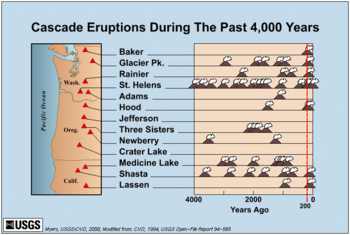
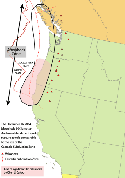
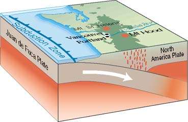
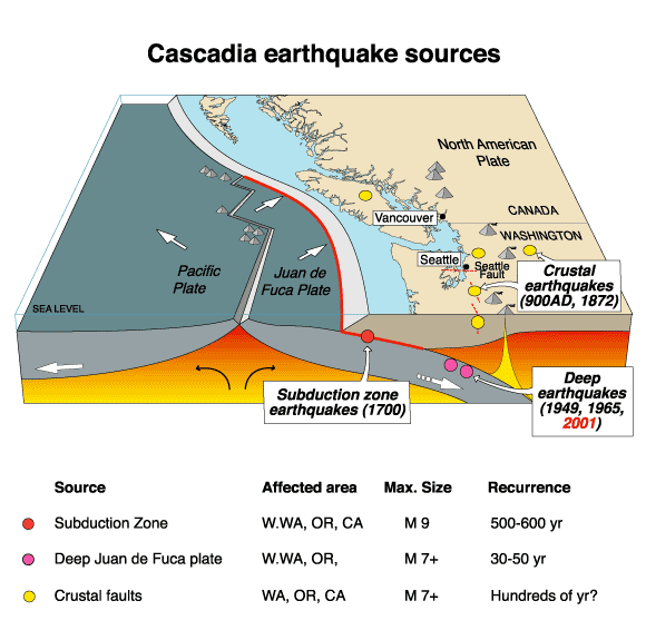
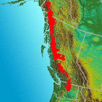
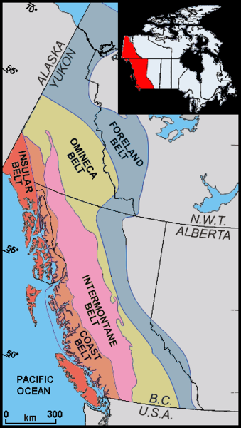
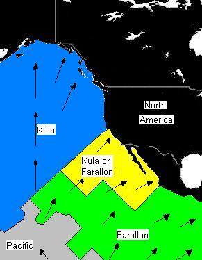
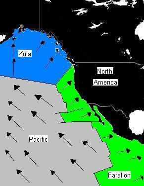
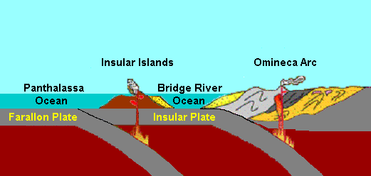
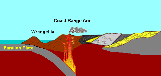
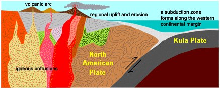
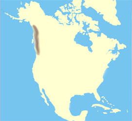
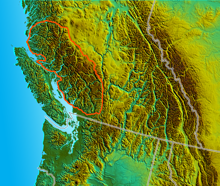
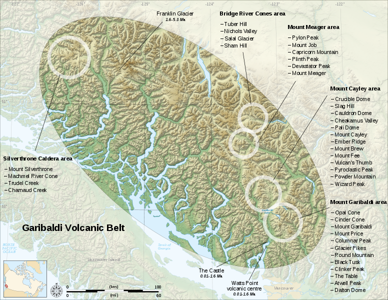
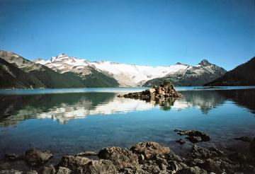
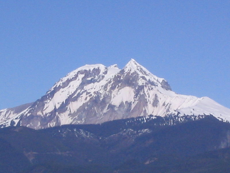
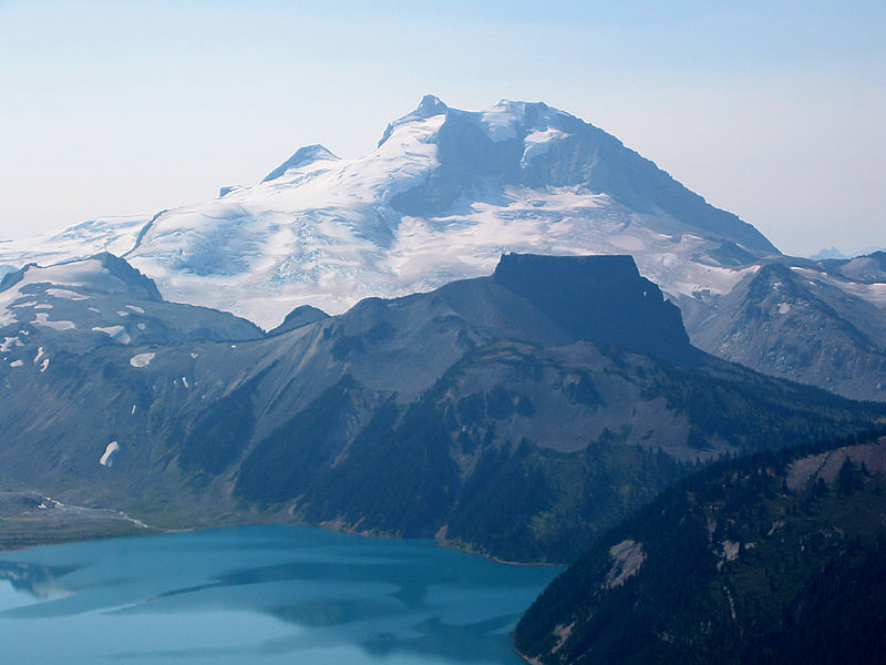
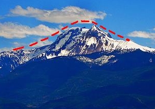
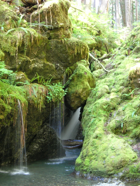
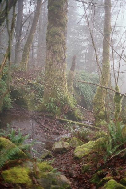
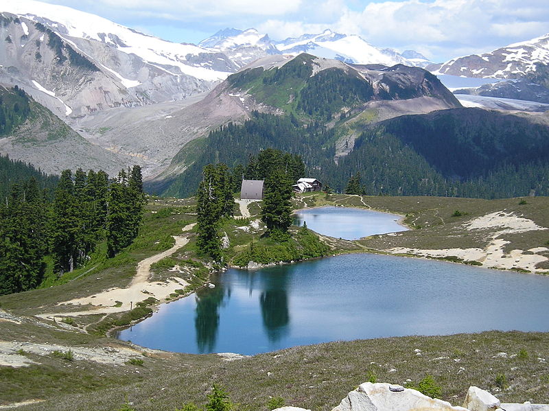
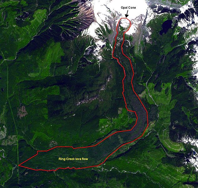
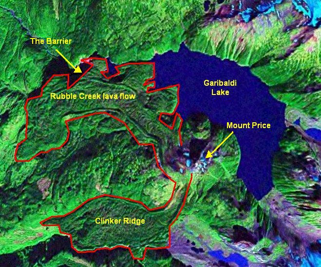
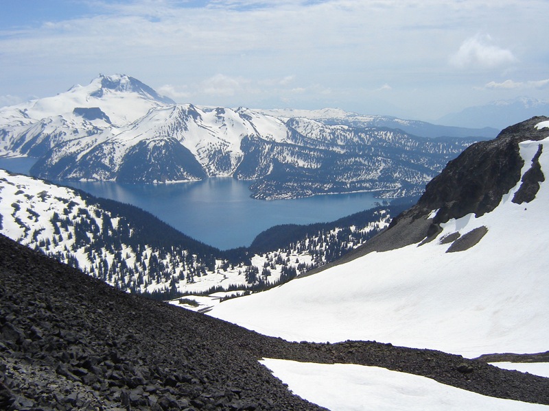
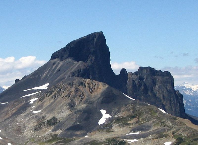
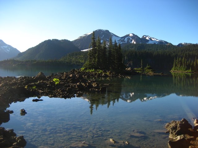
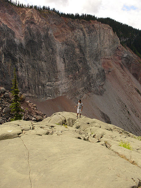
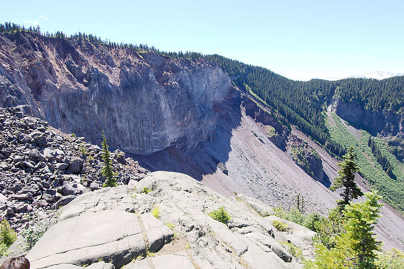
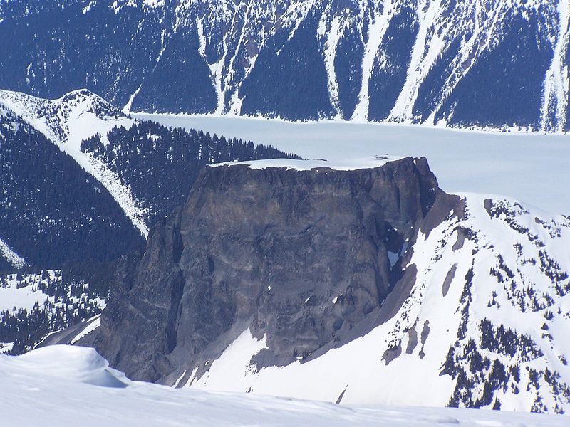
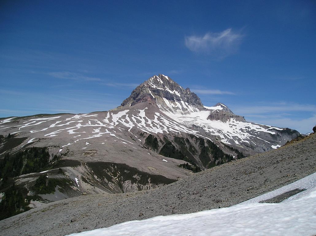
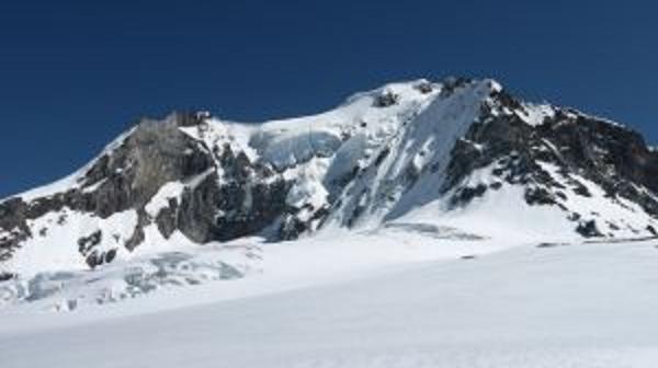
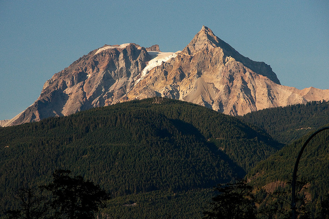
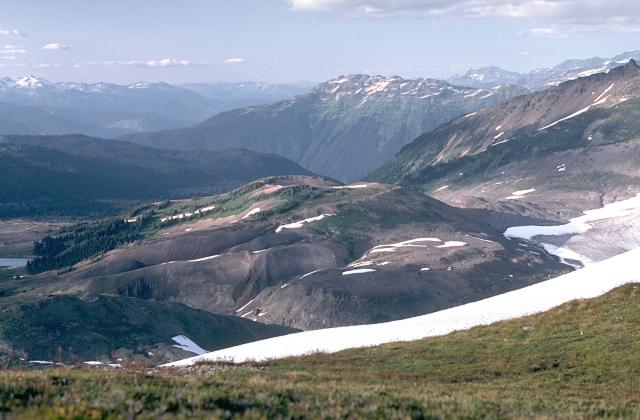


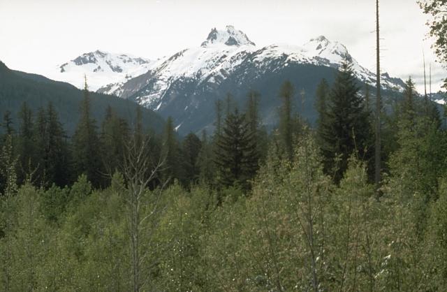
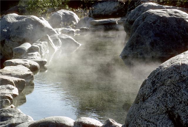
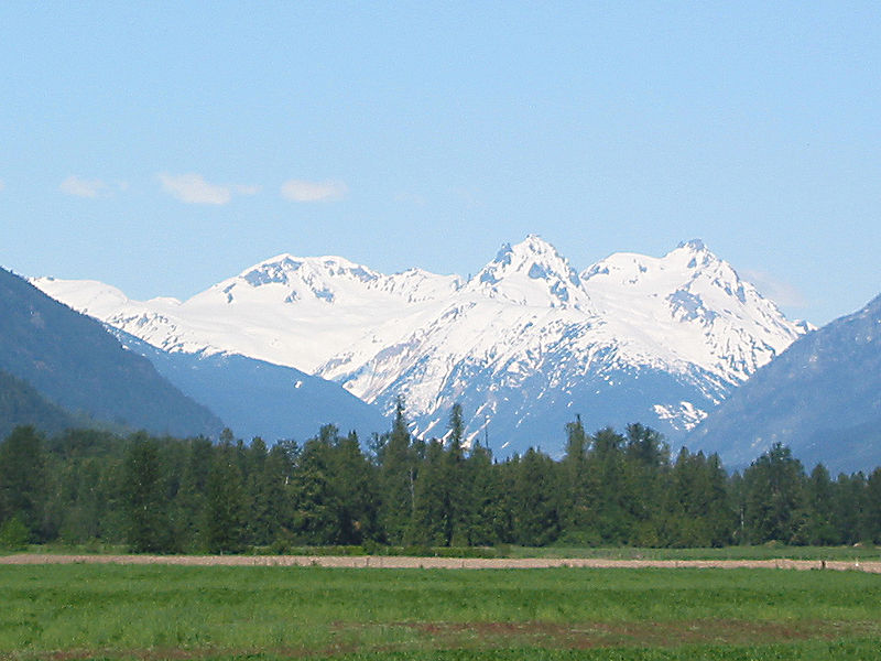
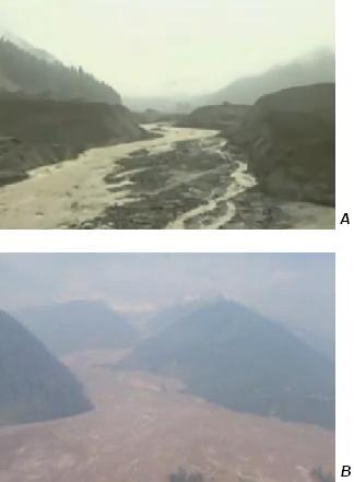
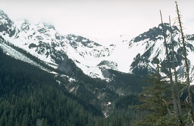
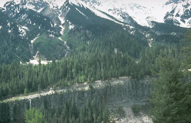
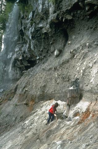
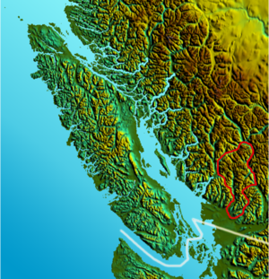
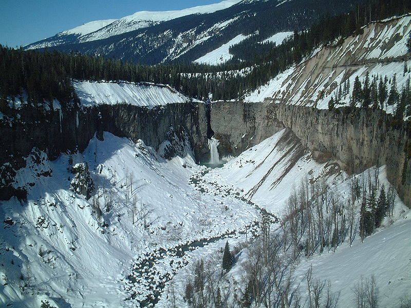
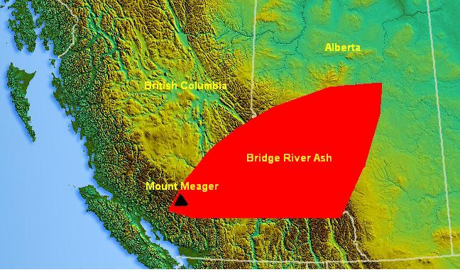
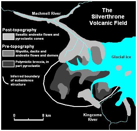
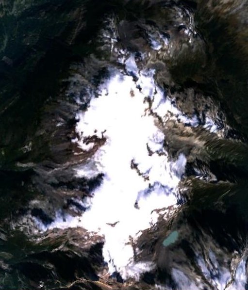
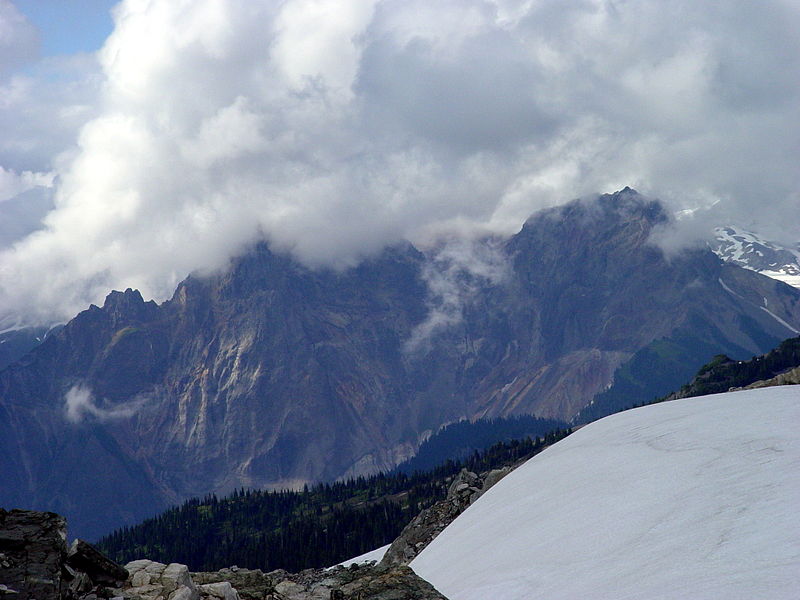
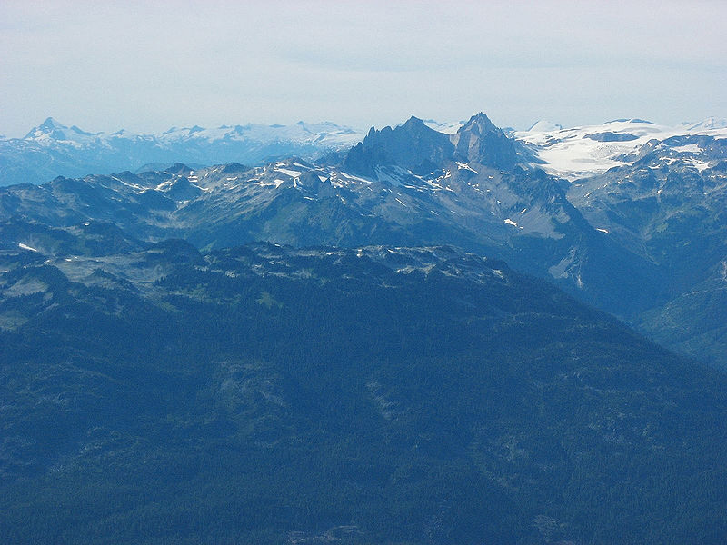
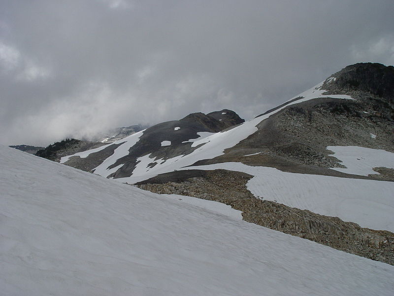
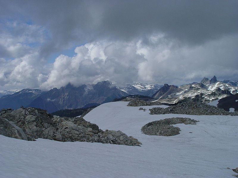
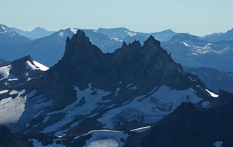
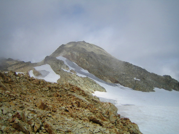
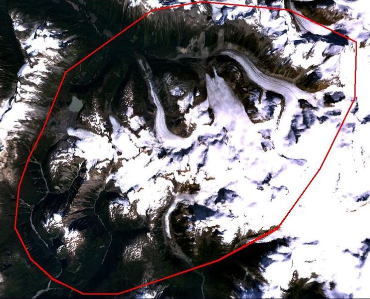
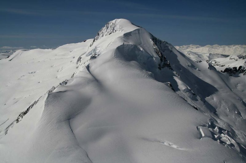
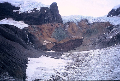
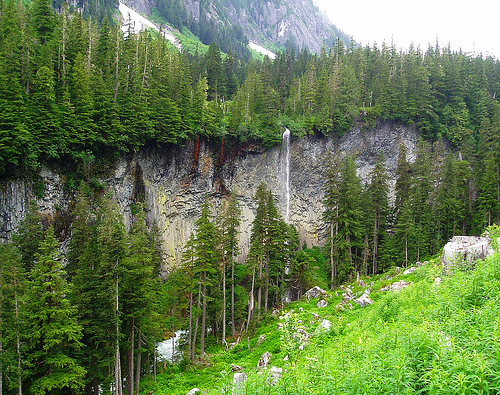
http://vulcan.wr.usgs.gov/Volcanoes/Canada/framework.html
Anaheim Volcanic Complex - Description
Cascade Range Volcanoes and Volcanics - Menu
Chilcotin Plateau Basalts - Description
Churchill - Location Map -- [Map,37K,InlineGIF]
Edgecumbe - Location Map -- [Map,37K,InlineGIF]
Edziza - Location Map -- [Map,37K,InlineGIF]
Garibaldi - Description
Garibaldi - Location Map -- [Map,37K,InlineGIF]
Garibaldi Lake Volcano - Description
Garibaldi Volcanic Belt - Description
Glaciations, Ice Sheets, and Volcanoes - Description -- Canada''s volcanoes and the Ice Age
Glaciations, Ice Sheets, Glacial Lakes, and Floods - Description -- general information about the Ice Sheets, including the Cordilleran Ice Sheet
Glaciations, Ice Sheets, Glacial Lakes, and Floods - Menu -- general information about the Ice Sheets, including the Cordilleran Ice Sheet
Hoodoo Mountain - Description
Hoodoo Mountain - Location Map -- [Map,37K,InlineGIF]
Iskut - Location Map -- [Map,37K,InlineGIF]
Lava Fork - Location Map -- [Map,37K,InlineGIF]
Major Volcanoes and Volcanic Areas of Western Canada - Map -- [Map,37K,InlineGIF]
Meager (Mount Meager) and Meager Mountain Volcanic Complex - Description
Meager Mountain - Location Map -- [Map,37K,InlineGIF]
Nazko - Location Map -- [Map,37K,InlineGIF]
Stikine Volcanic Belt - Description
Tseaux - Location Map -- [Map,37K,InlineGIF]
Tuya Volcanic Field - Location Map -- [Map,37K,InlineGIF]
Volcano Mountain - Location Map -- [Map,37K,InlineGIF]
Volcanoes and Volcanic Areas of Western Canada - Map -- [Map,37K,InlineGIF]
Wells Gray - Clearwater Volcanic Field - Description
Wells Gray - Location Map -- [Map,37K,InlineGIF]
Wrangell Volcanic Belt - Description
Canada has examples of almost every type of volcano. Although none are erupting now, at least 3 did in the last few hundred years and numerous others have the potential to erupt in the near future. Other countries'' volcanoes also can affect Canadians: eruptions in Alaska or along the west coast of the U.S.A. can impact agriculture and air travel across western Canada. Mount Baker in particular has the potential to affect the Fraser Valley. The volcanoes younger than about 5 million years in western Canada can be grouped into 6 volcanic belts ... The scattering of volcanoes in south-central British Columbia that don''t fit into the shown belts are the youngest members of the Chilcotin Plateau Basalt field. This belt was most active between 5 and 23 million years ago, but has seen activity as recently as 40 thousand years ago
Anahim Volcanic Belt
This nearly east-west line of volcanoes stretches from the west coast of British Columbia, just north of Vancouver Island, and reaches into the Interior Plateau near Quesnel. The volcanoes generally get younger as you go from the coast to the interior. These volcanoes probably formed as a result of the North American continent sliding westward over a small "hotspot", like the one feeding the Hawaiian islands. Volcanoes in this belt include the Rainbow, Ilgachuz, and Itcha ranges, and the Nazko cone which is only 7,200 years old.
Chilcotin Plateau Basalts
A zone of small-volume basaltic lava flow eruptions about 150 kilometers inland from and running parallel to the Garibaldi volcanic belt. Activity in this area is thought to be a result of extension of the crust behind the coastal subduction zone, a common phenomenon worldwide termed "back-arc extension volcanism". Chilcotin eruptions happened mainly 6-10 million years ago and 2-3 million years ago in the early stages of Garibaldi belt activity. In addition there have been a few eruptions in the Pleistocene (0.01 to 1.6 million years ago).
Garibaldi Volcanic Belt
The Garibaldi Volcanic Belt is the northern extension of the Cascades Volcanic Belt in the northwestern United States and contains the most explosive young volcanoes in Canada. It''s volcanoes are also the closest to British Columbia''s densely populated southwest corner. These volcanoes are the result of subduction of the Juan de Fuca tectonic plate beneath the North American tectonic plate; the plates meet just seaward of the west coast of Vancouver Island. The volcanoes of the Garibaldi Volcanic Belt generally are stratovolcanoes typical of subduction zones, and include Mount Garibaldi, Mount Cayley, and Mount Meager. Mount Meager''s eruption 2,350 years ago is the youngest explosive eruption in Canada. It was similar to that of Mount St. Helens in 1980 and the ongoing eruption of Montserrat in the Caribbean.
Stikine Volcanic Belt
This large area of volcanism stretches from just north of Prince Rupert, into the Yukon Territory and the Alaska border. It is the most active volcanic region in Canada, containing more than 100 volcanoes, 3 of which erupted in the last few hundred years (2 witnessed by people). These volcanoes formed due to extensional cracking of the crust in response to the Pacific Ocean plate dragging northward along the edge of the North American plate, on its way to the Aleution subduction zone. This belt includes the volcanoes Volcano Mountain, Mount Edziza, Level Mountain, and the extremely youthful Tseax Cone (240 years), Lava Fork (360 years), and Ruby Mountain (103 years).
Wells Gray - Clearwater Volcanic Field
The Wells Gray - Clearwater Volcanic Field is a tight cluster of basaltic volcanoes, and includes the Quesnel Cone Group. The origin of this volcanism is not yet clear, but appears to be a result of local crustal thinning. Many of these eruptions occurred during periods of glaciation, so the eruptions interacted with the ice sheets in complex ways, forming distinctive volcanic forms. A number of these eruptions have occurred in the last 10,000 years. The volcanoes included in this field are Pyramid Mountain and Kostal Cone.
Wrangell Volcanic Belt
This belt of volcanoes lies largely in Alaska but extends across the border into southwestern Yukon Territory. It formed as a result of melting of the crust due to subduction of the Pacific Ocean plate beneath the North American plate at the Aleutian Arc. It includes the volcanoes Mount Wrangell, which has been active historically, and Mount Churchill, which has had 2 large-magnitude explosive eruptions in the last 2,000 years that blanketed most of the Yukon with ash.
Canada is commonly thought to occupy a gap in the Pacific Ring of Fire between the Cascade volcanoes of the western United States and the Aleutian volcanoes of Alaska, yet the Cordillera of British Columbia and Yukon includes more than 100 separate volcanic centers that have been active during the Quaternary. Many of these are small monogenetic cones but others, such as the vast shield and dome complex of Mount Edziza, are products of repeated eruptions that began in the Miocene and continued episodically into Recent times. Others, such as Mount Garibaldi and Meager Mountain, are northern manifestations of Cascade volcanism which differ from the High Cascade volcanoes of the United States only in their more advanced stage of glacial erosion. Because volcanic activity in western Canada was contemporaneous with the ebb and flow of Cordilleran glaciations, many of the volcanoes display ice contact features. Mount Garibaldi itself is a supraglacial volcano which erupted onto a regional ice sheet. Others, such as Hoodoo Mountain, were contained within basins thawed in the ice and assumed the flat-topped form of tuyas. Still others, such as the subglacial mounds of the Clearwater Field, were erupted under glacial ice to form piles of pillow lava and hyaloclastite. Although no historic eruptions have been recorded in Canada, native legends of lava flows destroying villages and killing fish are conformed by radiocarbon dates of 200-250 years ago on carbonized wood beneath basalt flows in the Stikine Volcanic Belt.
Neogene and Quaternary igneous rocks in the Canadian Cordillera are concentrated along five principal volcano-tectonic belts that are closely related to the modern tectonic regime (Souther, in press). In southwestern British Columbia, the Pemberton and Garibaldi volcanic belts and the Chilcotin Group plateau basalt define an arc-backarc pair related to subduction of the Juan de Fuca and Explorer plates under the continental margin. The Anahim Volcanic Belt, which extends from the coast near Bella Bella easterly across central British Columbia to the eastern boundary of the Intermontane Belt, is interpreted to be the trace of a mantle hot spot. The Stikine Volcanic Belt, which forms a broad zone through northwestern British Columbia and the southern Yukon, is thought to be a zone of extension developed in response to shear along the adjacent, transcurrent boundary between the continent and Pacific crust. The Wrangell Volcanic Belt, extending from Alaska into southwestern Yukon, is part of a continental arc related to convergence between the Pacific and the northern North American plates. Neogene volcanic activity outside of the five main volcano-tectonic belts was limited to the eruption of small basaltic centers in the Clearwater-Quesnel and McConnell Creek areas near the suture bounding the eastern edge of Quesnellia, and to the eruption of basaltic to rhyolitic volcanoes and hypabyssal rocks of the Alert Bay Belt possibly coincident with the subducted boundary between the Explorer and Juan de Fuca plates.
Simpkin and Siebert, 1994, Volcanoes of the World: Cambridge University Press
Canada Holocene Volcanoes
Alligator Lake - Volcanic Field - Holocene
Bridge River Cones - Volcanic Field - Holocene
Crow Lagoon - Pyroclastic Cone - Holocene
Edziza - Stratovolcano - Radiocarbon
Fort Selkirk - Volcanic Field - Holocene
Garibaldi Lake - Volcanic Field - Holocene
Garibaldi, Mount - Stratovolcano - Radiocarbon
Heart Peaks - Shield Volcano - Holocene
Hoodoo Mountain - Subglacial Volcano - Holocene
Iskut-Unuk River Cones - Cinder Cones - Radiocarbon
Level Mountain - Shield Volcano - Holocene
Meager - Complex Volcano - Radiocarbon
Milbanke Sound Group - Cinder Cones - Holocene
Nazko - Cinder Cones - Radiocarbon
Ruby Mountain Cinder Cones Historical
Satah Mountain - Volcanic Field - Holocene
Silverthrone - Caldera Holocene
Spectrum Range - Shield Volcano - Holocene
Tseax River Cone - Pyroclastic Cone - Radiocarbon
Wells Gray - Clearwater - Cinder Cones - Dendrochronology
Cascade Range Volcanoes and Volcanics
http://vulcan.wr.usgs.gov/Volcanoes/Cascades/framework.html
http://vulcan.wr.usgs.gov/Volcanoes/Cascades/volcanoes_cascade_range.html
http://vulcan.wr.usgs.gov/Volcanoes/Cascades/Images/framework.html
http://vulcan.wr.usgs.gov/Glossary/PlateTectonics/framework.html
http://en.wikipedia.org/wiki/Geology_of_the_Pacific_Northwest
next
volcanoes
Garibaldi Volcanic Belt
Cascadia subduction zone
Cascade Volcanoes