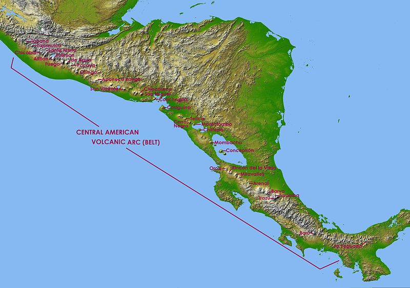
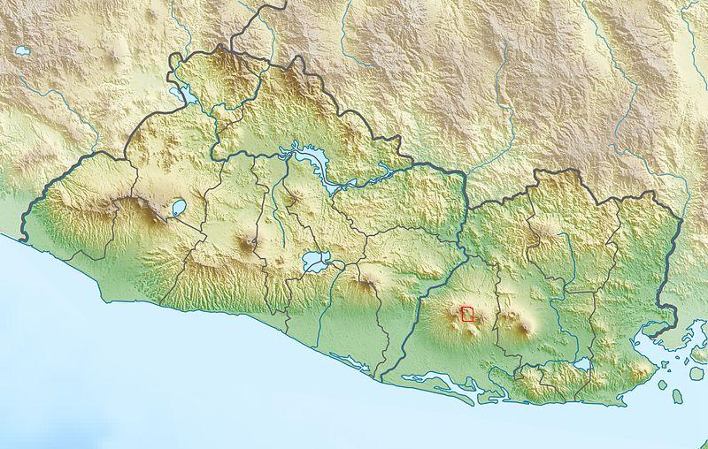
 | CAVA Volcanoes, south el Salvador |
|
|
|
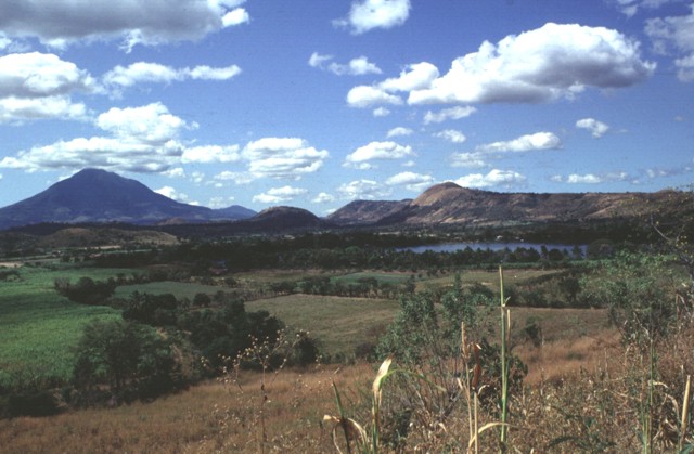
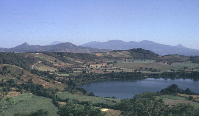
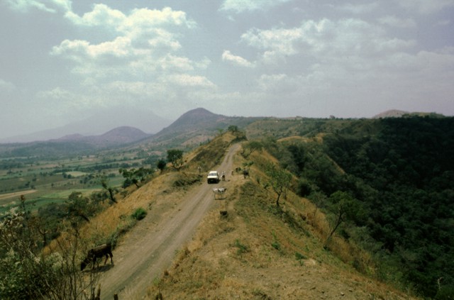
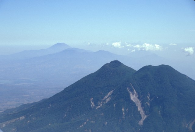
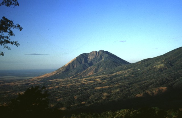
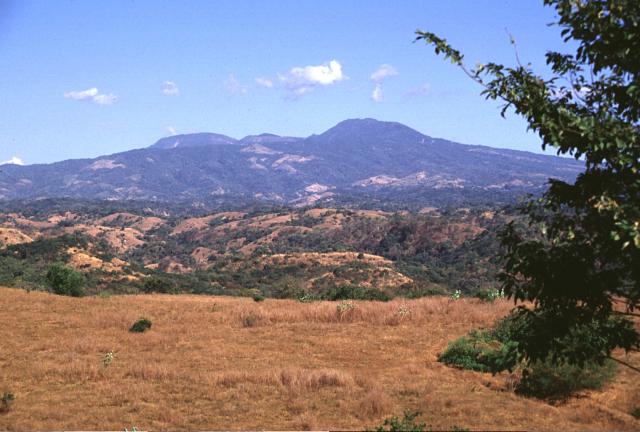
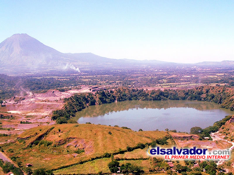
The Apastepeque volcanic field consists of a cluster of about two dozen lava domes, cinder cones, and explosion craters NE of San Vicente volcano, the large stratovolcano at the left. The lake-filled Laguna de Apastepeque crater is visible at the right, below Cerro Las Delicias lava dome. On the left-center horizon is Cerro Santa Rita lava dome.Photo by Carlos Pullinger, 1996 (Servicio Nacional de Estudios Territoriales, El Salvador).http://www.volcano.si.edu/world/volcano.cfm?vnum=1403-071&volpage=photos |
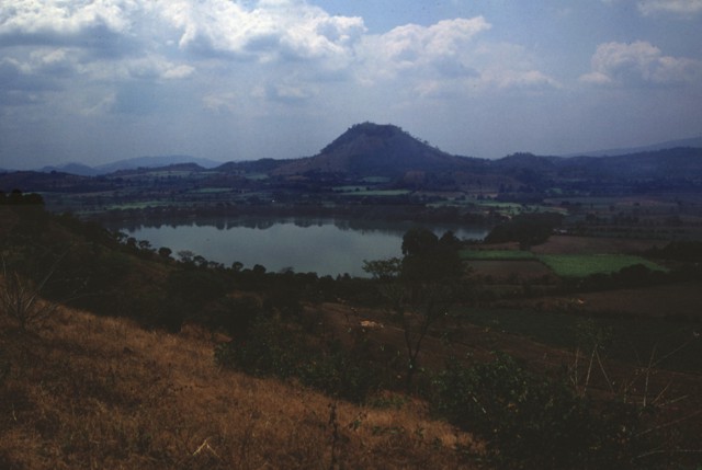
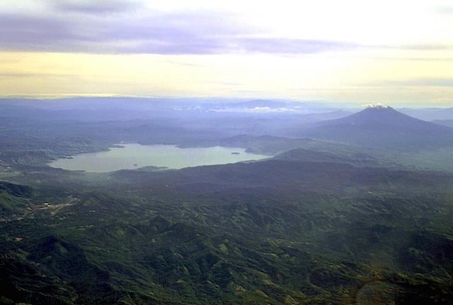
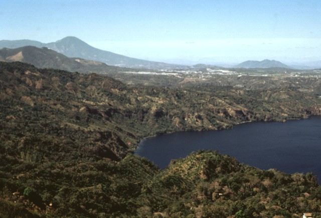
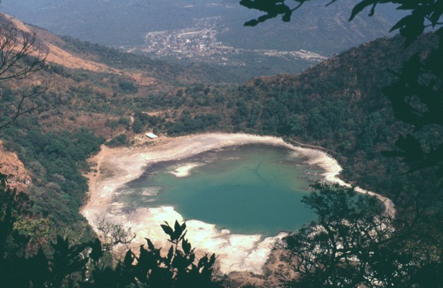
Apastepeque Volcanic Field, Holocene, 13o72N, 88o77W, elevation 700m. The Apastepeque volcanic field north of the city of San Vicente consists of a dense cluster of about two dozen chemically diverse lava domes, cinder cones, and maars NE of San Vicente volcano. Laguna de Apastepeque is seen here from the WNW with peaks of the Tecapa-San Miguel volcano group in the background. The visible walls of the 800-m-wide lake are only about 5 m high, but the lake is approximately 50 m deep.Photo by Carlos Pullinger, 1996 (Servicio Nacional de Estudios Territoriales, El Salvador). http://www.volcano.si.edu/world/volcano.cfm?vnum=1403-071&volpage=photos Apastepeque volcano is a young volcanic field 8 km north of San Vicente town in central El Salvador. The Volcanic features contains about 24 closely spaced cinder cones, lava flows, lava domes, and maars. The latter are now filled by lakes, such as Laguna de Apastepeque and Laguna Chalchuapan. The older vents in the volcanic field erupted andesitic-to-dacitic lava domes, sometimes following dacitic pumice eruptions. The younger vents formed basaltic cinder cones and phreatic and phreatomagmatic explosions left up to 100 m deep maars. Eruptions less then 10KA, Typical eruption style: effusive and explosive http://www.volcanodiscovery.com/apastepeque.html Laguna de Apastepeque in the foreground is one of two lake-filled phreatic explosion craters in the Apastepeque volcanic field. The broad range in the distance on the right-hand horizon to the SE is the Tecapa massif. At the far right is the sharp peak of Volcбn Taburete. San Miguel volcano can be seen on the left-center horizon behind the ridge in the middle ground.Photo by Carlos Pullinger, 1994 (Servicio Nacional de Estudios Territoriales, El Salvador).http://www.volcano.si.edu/world/volcano.cfm?vnum=1403-071&volpage=photos |
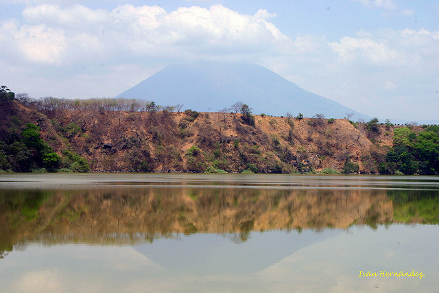
The low-rimmed Laguna de Apastepeque is one of two large lake-filled craters in the Apastepeque volcanic field. The 800-m-wide lake is about 50 m deep. The lake is surrounded by flat-lying beds of basaltic ash containing angular blocks of andesite.Photo courtesy of Comision Ejecutiva Hidroelйctricia del Rio Lempa (CEL), 1992.http://www.volcano.si.edu/world/volcano.cfm?vnum=1403-071&volpage=photos |
Laguna Chalchuapa (also spelled Chalchuapan) is one of two lake-filled explosion craters of the Apastapeque volcanic field. The 700-m-wide crater is located immediately NE of the dry explosion crater Hoyo de Calderas. Coarse andesitic and basaltic lahar deposits underlie dacitic pumice deposits exposed in the walls of Laguna Chalchuapa.Photo by Giuseppina Kysar, 1999 (Smithsonian Institution).http://www.volcano.si.edu/world/volcano.cfm?vnum=1403-071&volpage=photos |
Cerro El Cerron (right-center), one of the largest lava domes of the Apastepeque volcanic field, rises to the south above Laguna de Apastepeque. The 740-m-high Cerro Cerron (also known as Cerro de las Ramirez) is an andesitic lava dome that rises 240 m above the valley floor and has a small depression at its summit. The Pan-American highway cuts across the valley floor between Laguna de Apastepeque and Cerro Cerron).Photo by Giuseppina Kysar, 1999 (Smithsonian Institution).http://www.volcano.si.edu/world/volcano.cfm?vnum=1403-071&volpage=photos |
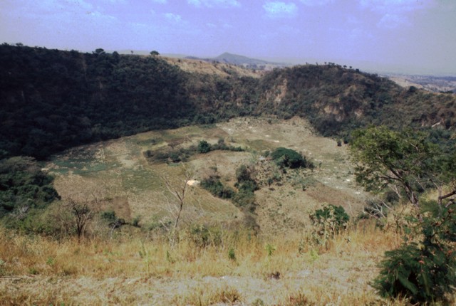
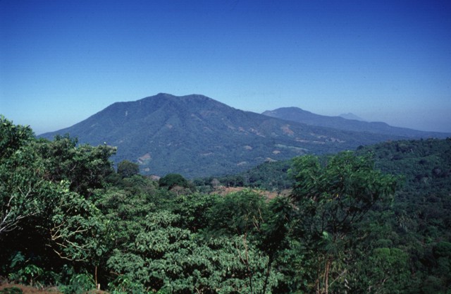
Several different volcanic features of the Apastepeque volcanic field can be seen in this view from the rim of Hoyo de Calderas, a phreatic explosion crater. The peak on the center horizon and the rounded peak beyond it to the left are Cerro Las Delicias and Cerro Santa Rita, respectively. Both are lava domes. The conical volcano in the haze behind Cerro Santa Rita is San Vincente stratovolcano.Photo by Giuseppina Kysar, 1999 (Smithsonian Institution).http://www.volcano.si.edu/world/volcano.cfm?vnum=1403-071&volpage=photos |
Hoyo de Calderas, also known as El Ollo, is a phreatic explosion crater located NW of Laguna de Apastepeque. The steep-walled crater, seen here from the SE, is 700 m wide and 140 m deep. Unlike nearby lake-filled Laguna de Chalchuapa and Laguna de Apastepeque, the floor of Hoyo de Calderas is dry and available for agricultural use. Photo by Giuseppina Kysar, 1999 (Smithsonian Institution).http://www.volcano.si.edu/world/volcano.cfm?vnum=1403-071&volpage=photos |
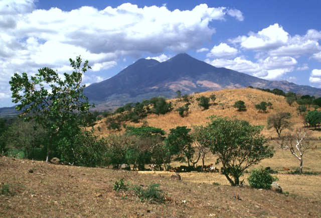
San Vicente volcano, elevation 2181m, or, as is known in Nahuatl language, Chichontepec.Geologically, San Vicente volcano lies on the southern fault of the Central American graben, which in this part of the country runs E-W and has a width of about 8-10 km. The northern graben faults are easily identified just north of the town of Tepetitan |
San Vicente volcano, like San Miguel volcano, rises in relative isolation about 2000 m above the Pacific coastal plain of El Salvador. The volcano was constructed within a caldera left by collapse of the Plio-Pleistocene La Carbonera volcano, whose western flanks form the low forested hills in the left foreground. The eastern rim of the caldera has been buried by growth of San Vicente. The volcano was constructed within the 20-30 km wide Central Graben that cuts Tertiary volcanic basement rocks.Photo by Lee Siebert, 1999 (Smithsonian Institution).http://www.volcano.si.edu/world/volcano.cfm?vnum=1403-07=&volpage=photos |
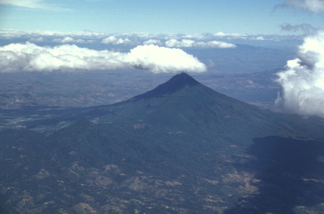
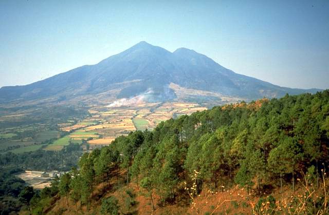
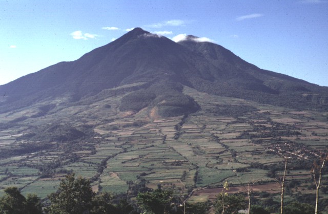
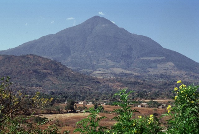
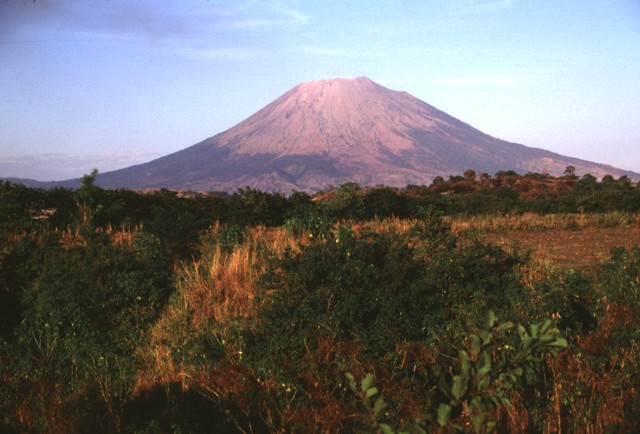
The twin summits of San Vicente volcano form one of El Salvador''s most prominent natural landmarks. Fresh scarps from landslides produced during the January 2001 earthquake scar the flanks of the volcano. The San Vicente area and towns at the foot of the volcano were particularly hard hit by the tectonic earthquake and suffered extensive damage. The Tecapa volcanic complex and conical San Miguel volcano rise in the distance.Photo by Paul Kimberly, 2002 (Smithsonian Institution).http://www.volcano.si.edu/world/volcano.cfm?vnum=1403-07=&volpage=photos Flights from the international airport at San Salvador often pass close to San Vicente volcano, whose twin summits are seen here from the south. The low hill at the extreme right is the rim of La Carbonera caldera, which was formed as a result of a major plinian explosive eruption during the Pleistocene. Destruction of this tholeiitic volcano about 550,000-590,000 years ago was followed by growth of the calc-alkaline San Vicente (Chichontepec) volcano. San Vicente, 2182 m is aHolocene stratovolcano in central El Salvador. It is located next to the town of San Vicente (hence the name) and is the second highest volcano in El Salvador. In the indigenous language Nahuat, double summit. The volcano has two craters located one in each summit, although not exactly at the top. Dense vegetation covers both summits. Numerous hot springs and fumaroles are found on the northern and western flanks of the volcano. To the northeast, at 820 metres in a ravine of 180 metres of longitude, there are fumaroles -- fountains of clear and muddy water or small volcanoes of mud.The last significant eruption occurred more than 1,700 years ago. The volcano may have had a very long history of repeated, and sometimes violent, eruptions, and at least once a large section of the volcano collapsed in a massive landslide. No recent eruptions, 2001 Earthquake.There was a magnitude 6.6 earthquake near the volcano on 13th February 2001. The earthquake generated over 25 landslides on the flank of the volcano which killed 39 people. Reports of an eruption following the earthquake were not confirmed. Photo by Paul Kimberly, 2002 (Smithsonian Institution).the twin 130 cu km andesitic Chichontepec edifice was constructed within the Pleistocene La Carbonera caldera.The summit of San Miguel volcano provides a vista down an E-W-trending volcanic chain between it and San Vicente volcano, the sharp-topped peak on the right horizon. The broad El Tigre volcano appears in the center of the photo beyond the slopes of Chinameca volcano in the right foreground. At the extreme left is Usulutan, and to its left the summit of Taburete volcano is hidden behind a small cloud. Behind El Tigre are the peaks of the Tecapa volcanic complex. An eastward-looking aerial view down the main Salvadoran volcanic front shows San Vicente volcano below the cloud in the foreground and Tecapa, El Tigre, and Usulutan volcanoes below the horizon at the upper right. The small cone in the saddle between Usulutan and El Tigre is Cerro Oromontique. Behind Tecapa and El Tigre is conical San Miguel volcano, and to its right in the far distance is Conchagua volcano, the easternmost on the Salvadoran mainland http://www.volcano.si.edu/world/volcano.cfm?vnum=1403-07=&volpage=photos |
The twin peaks of San Vicente volcano, also known as Chichontepec, rise dramatically to the SE of Lake Ilopango. The modern andesitic stratovolcano was constructed within the Pleistocene La Carbonera caldera, whose rim is visible only on its SW side. San Vicente volcano, the second highest in El Salvador, grew within the caldera to form a paired volcano with summit craters oriented along a WSW-ENE line. The northern and southern flanks are covered by lava flows from the central vent, but lava flows on the eastern side originated from a vent on the upper flank. Volcanism has continued into the Holocene, but the latest lava flows are covered by deposits from the major ca. 260 AD eruption from neighboring Ilopango volcano. Reports of historical eruptions in 1643 and 1835 are false (Catalog of Active Volcanoes of the World; Sapper, 1917), but numerous hot springs and fumaroles are found on the northern and western flanks of the volcano.San Vicente is one of several Salvadoran volcanoes that have been the sites of geothermal exploration projects. |
Lobate lava flows are seen on the northern flank of San Vicente volcano. These and other flows of San Vicente have not been dated, but all are overlain by pumice of the Tierra Blanca Joven (TBJ) formation, erupted from neighboring Ilopango caldera about 1750 years ago. Post-caldera lava flows constructing San Vicente volcano range from basaltic andesite to dacitic composition. Most satellitic vents are dacitic.Photo by Carlos Pullinger, 1994 (Servicio Nacional de Estudios Territoriales, El Salvador).http://www.volcano.si.edu/world/volcano.cfm?vnum=1403-07=&volpage=photos |
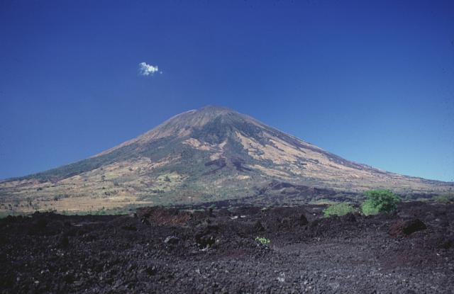
The easternmost summit of San Vicente volcano (also known as Chichontepec) is seen here from the NE along the road to the city of San Vicente. The hill in the left foreground is Cerro Ramirez, a flank cone that is one of the most recent vents of the volcanic complex. Although no historical eruptions are known from San Vicente, seismicity remains relatively high, and in 1936 a seismic swarm destroyed much of the city of San Vicente.Photo by Paul Kimberly, 1999 (Smithsonian Institution). http://www.volcano.si.edu/world/volcano.cfm?vnum=1403-07=&volpage=photos |
San Vicente is exceeded in height and volume only by Santa Ana among El Salvador''s volcanoes. The large hill in the foreground is part of the Tecoluca debris-avalanche deposit on the SE flank of San Vicente (also known as Chichontepec), whose twin summits appear in the background. The avalanche and associated lahars traveled about 25 km to the Rio Lempa. Photo by Lee Siebert, 1999 (Smithsonian Institution). The sharp-topped 2182-m-high eastern summit (right) is considered to be morphologically younger than the 2105-m-high western summit, although no dates have been obtained from San Vicente lava flows. The modern San Vicente volcano was constructed by the extrusion of thick lobate lava flows that originated primarily from the summit vents and a vent on the eastern flank.http://www.volcano.si.edu/world/volcano.cfm?vnum=1403-07=&volpage=photos |
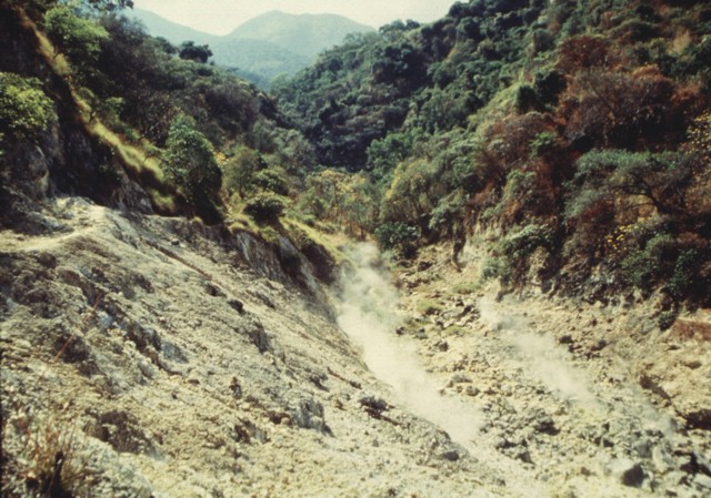
Steaming fumaroles rise from Agua Agria, a large thermal area on the flank of San Vicente volcano. Low-temperature fumaroles (<100 degrees centigrade) and hot springs are located along faults cutting the northern and western flanks of San Vicente.Photo courtesy of Comisiуn Ejecutiva Hidroelйctricia del Rнo Lempa (CEL), 1992.http://www.volcano.si.edu/world/volcano.cfm?vnum=1403-07=&volpage=photos |
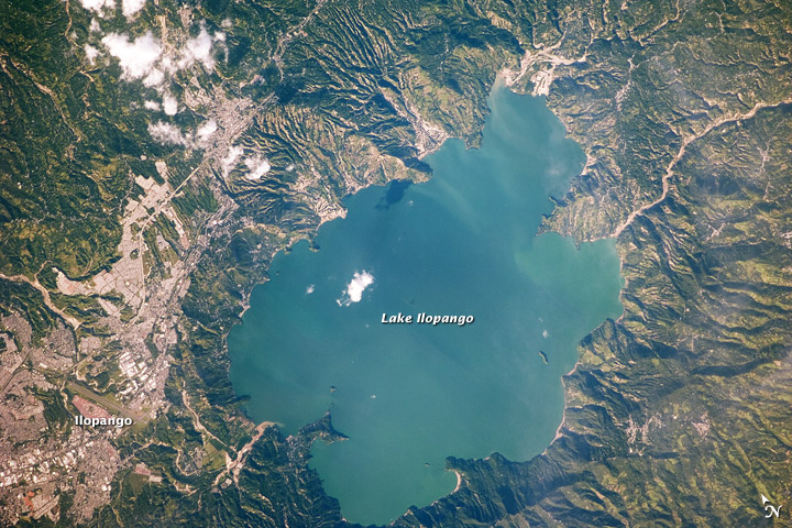
Lake Ilopango |
Tecapa |
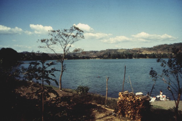
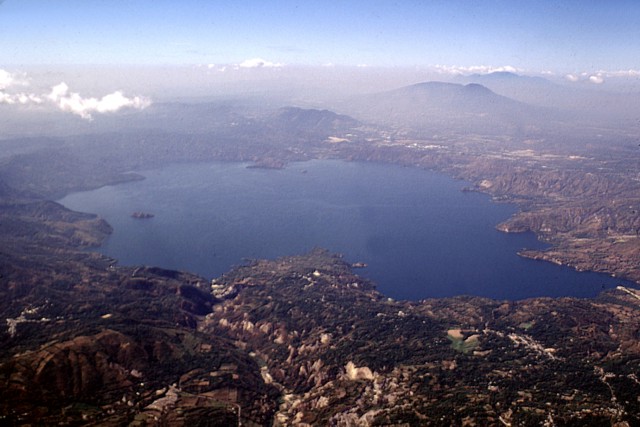
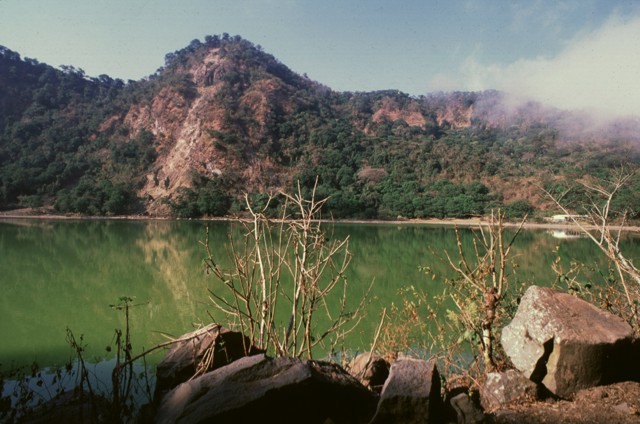
Lake Ilopango is seen in this aerial view from the SW with San Vicente stratovolcano at the right. The latest collapse of the 8 x 11 km Ilopango caldera occurred after a powerful eruption during the 5th century AD that produced widespread pyroclastic flows and devastated early Mayan cities. Dacitic lava domes form small islands near the shore of the lake and rocky islets near its center. The caldera was formed during four major eruptions, the last of which was about 1500 years ago. This eruption blanketed much of central and western El Salvador with ash and pumice Copyrighted photo by Stephen O''Meara.http://www.volcano.si.edu/world/volcano.cfm?vnum=1403-06=&volpage=photos |
Lake Ilopango seen from the east, San Salvador city and San Salvador Volcano can be seen just behind the lake looming in the haze. The scenic 8 x 11 km Ilopango caldera, filled by one of El Salvador''s largest lakes, has a scalloped 150-500 m high rim. The caldera, which lies immediately east of the capital city of San Salvador, is strongly controlled by regional faults of the central Salvador graben. Four major dacitic-rhyolitic explosive eruptions during the late Pleistocene and Holocene produced extensive pyroclastic-flow and pyroclastic-fall deposits that blanket much of El Salvador. The latest collapse of Ilopango caldera resulted from the massive 5th century AD Terra Blanca Joven (TBJ) eruption, which produced widespread pyroclastic flows and devastated early Mayan cities. Post-caldera eruptions formed a series of glassy dacitic and andesitic lava domes within the lake and near its shore. The Islas Quemadas, a group of low islets in the center of the lake that mark the summit of a largely submerged lava dome, were formed in 1879-80 during the only historical eruption of Ilopango. Lake Ilopango, elevation 450m, last eruption 1880, is a crater lake which fills a scenic 8Ч11 km (72 km2) volcanic caldera in central El Salvador. The caldera, which contains the second largest lake in the country has a scalloped 100 m to 500 m high rim. Four major dacitic - rhyolitic eruptions occurred during the late Pleistocene and Holocene, producing pyroclastic flows and tephra that blanketed much of the country.The caldera collapsed most recently during a cataclysmic eruption in the 5th century AD. which produced widespread pyroclastic flows. This eruption produced about 25 km3 of tephra (20 times as much as the 1980 eruption of Mount St. Helens), thus rating a 6 on the (VEI) Volcanic Explosivity Index. One of the most prominent tourist destinations is a town called Apulo, which was one of the towns affected by the 2009 floods and mudslides caused by Hurricane Ida.Later eruptions formed several lava domes within the lake and near its shore. The only historical eruption, which occurred from December 31, 1879, up to March 26, 1880, produced a lava dome and had a VEI of 3. The lava dome reached the surface of the lake, forming the islets known as Islas Quemadas.The 8 x 11 km wide Ilopango caldera fills the center of the image in this view from the ESE. Fresh, light-colored exposures of the Tierra Blanca Joven formation in the foreground associated with the latest caldera-forming episode were in part created by landsliding during the January 2001 earthquake. The capital city of San Salvador lies beyond the lake, between it and San Salvador volcano (upper right). The Santa Ana volcanic complex lies beyond San Salvador volcano on the right horizon. http://en.wikipedia.org/wiki/Ilopango_(volcano) |
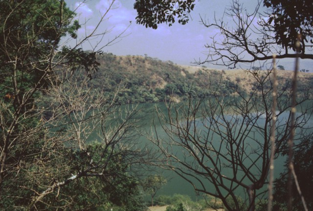
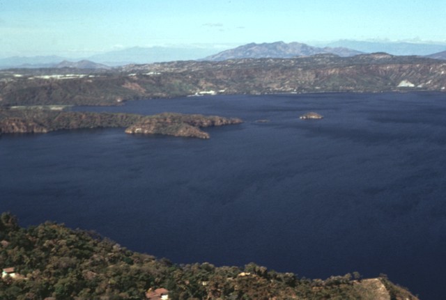
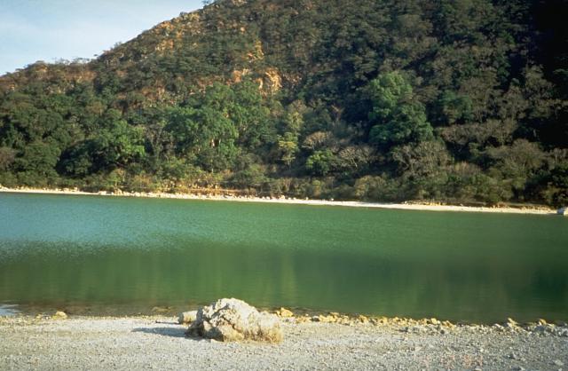
The two tiny islands in the center of Lake Ilopango barely visible above and slightly to the left of the house in the foreground are the Islas Quemadas. These are post-caldera dacitic lava domes that were emplaced December 31, 1879 to March 1880 during Ilopango''s only historical eruption. A huge column of ash and incandescent rocks was erupted on January 20, and the dome breached the surface on January 23. It reached a height of 50 m above the lake surface before violent explosions March 5 destroyed most of the subaerial part of the dome. The 8 x 11 km Ilopango caldera, filled by one of El Salvador''s largest lakes, has a scalloped 150-500 m high rim. The caldera, seen here from its west rim, is strongly controlled by regional faults of the central Salvador graben. Its latest collapse resulted from the massive 5th century AD Tierra Blanca eruption that produced widespread pyroclastic flows and devastated early Mayan cities. The latest of a series of post-caldera eruptions formed the Islas Quemadas, a group of low islets in the center of the lake, in 1879-1880.Photo by Kristal Dorion, 1994 The SW wall of Ilopango caldera rises about 500 m above the surface of the caldera lake. Punta La Peninsula (center) on the western side of the caldera extends a kilometer into the lake. The high wall on the southern side of the lake is a fault scarp in southward-dipping rocks of the Pliocene Balsamo formation. The scenic lake is a popular resort destination from the capital city of San Salvador, and the shores of the lake are dotted with resorts and vacation homes. (U.S. Geological Survey).The 8 x 11 km wide caldera was formed during four major Quaternary eruptions, the last of which occurred about 1500 years ago. The southern caldera wall rises about 500 m above the lake, which has a maximum depth of about 250 m. The small island at the left side of the lake (above the flowering shrub) is Isla Cerro los Patos, a post-caldera dacitic lava dome. http://www.volcano.si.edu/world/volcano.cfm?vnum=1403-06=&volpage=photos |
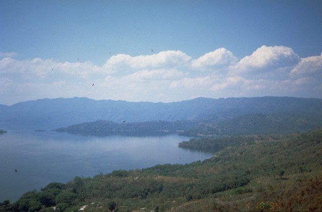
The western side of Lake Ilopango is seen from the southern rim of Ilopango caldera. The broad peak on the right-hand horizon is Guazapa, a Pleistocene volcano in the Interior Valley of El Salvador that has young pyroclastic cones at its base. The northern wall of Ilopango caldera rises about 400-500 m above the lake. Much of the caldera rim is covered with a thick blanket of deposits from the caldera-forming eruptions, but some lava domes are exposed in the caldera wall. Photo by Bill Rose, 1978 (Michigan Technological University).http://www.volcano.si.edu/world/volcano.cfm?vnum=1403-06=&volpage=photos Lago Ilopongo. Like most of the lakes in the Central American volcanic belt, this lake has a volcanic origin. It lies in a large caldera. Last eruption 1880 |
The SW corner of Ilopango caldera is visible in the foreground with the outskirts of the capital city of San Salvador in the middle distance. The high peak on the left horizon to the NW is El Picacho, part of the San Salvador volcanic complex, a historically active volcano overlooking the capital city. Below it to the left is San Jacinto, a Pliocene lava dome complex. The low peak on the upper right horizon is Cerro Nejapa, a Pliocene volcano in the Interior Valley of El Salvador.Photo by Bill Rose, 1978 (Michigan Technological University).http://www.volcano.si.edu/world/volcano.cfm?vnum=1403-06=&volpage=photos |
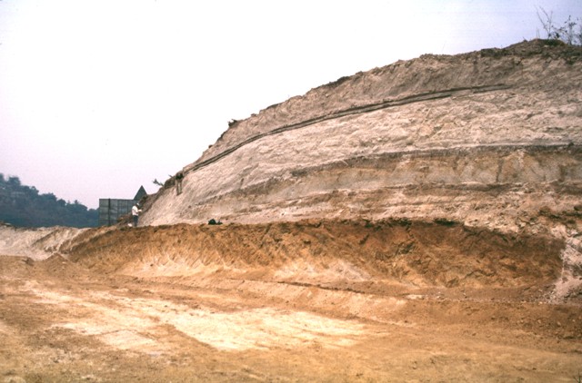
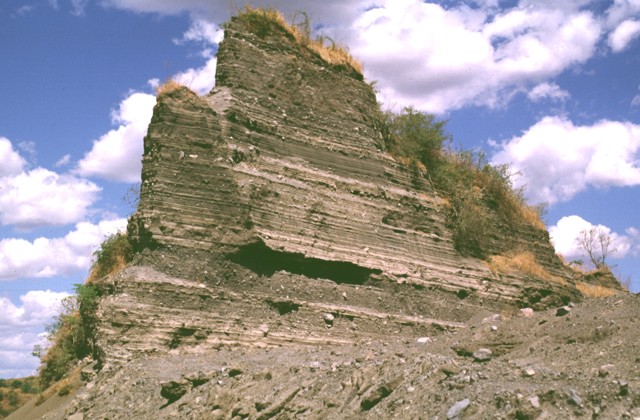
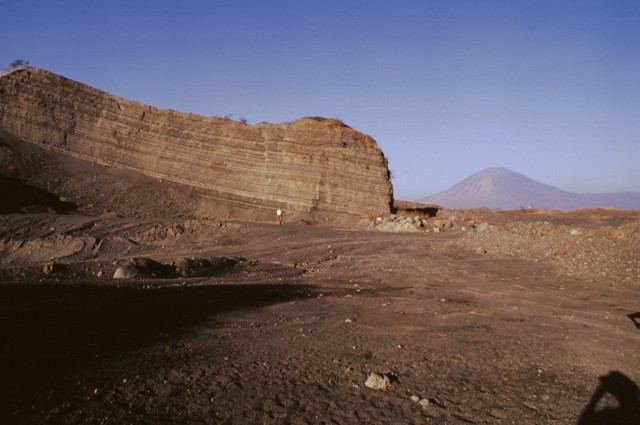
The four major pyroclastic units associated with the incremental formation of Ilopango caldera are exposed in this quarry. The Tierra Blanca ("White Soil") unit that blankets much of central and western El Salvador consists (from bottom to top) of the Pleistocene TB4 (the orange-colored unit at the base), TB3, and TB2 units (separated by thin soils), and the Holocene TBJ unit. The latter is called the Tierra Blanca Joven (the young Tierra Blanca) and was erupted about 1500 years ago. Note the geologist on the left side of the outcrop for scale.Photo by Carlos Pullinger, 1996 Tierra Blanca 3) deposit, the second oldest of four major deposits associated with the formation of Ilopango caldera. This outcrop is located south of the town of Panchimalco, about 20-30 km SW of Ilopango caldera. (Servicio Nacional de Estudios Territoriales, El Salvador). http://www.volcano.si.edu/world/volcano.cfm?vnum=1403-06=&volpage=photos |
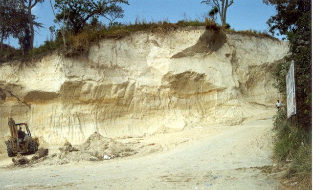
White-colored pyroclastic-flow and -fall deposits from Ilopango caldera known collectively as Tierra Blanca (White Soil) blanket much of central and western El Salvador. This quarry near the city of Cojutepeque, 9 km ENE of the caldera, exposes the Tierra Blanca Joven (TBJ) formation, produced during the youngest of the several Tierra Blanca eruptions about 1500 years ago. The eruption destroyed early Mayan cities and forced their abandonment for decades to centuries. Photo by Giuseppina Kysar, 1999 (Smithsonian Institution).http://www.volcano.si.edu/world/volcano.cfm?vnum=1403-06=&volpage=photos |
Many volcanic peaks dot the landscape of central Salvador. Volcanoes on Coastal Plain of El Salvador |
Taburete |
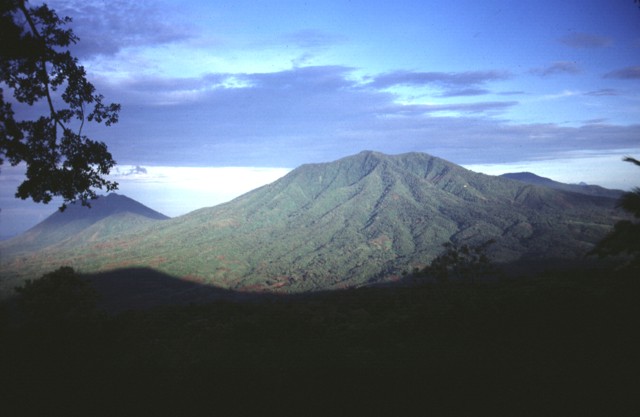
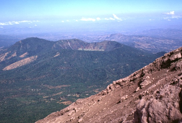
Taburete is a stratovolcano in central El Salvador, rising above the coastal plain between the San Vicente and San Miguel volcanoes. It is topped by a well-preserved, 150¢300 m deep summit crater, with the true summit on the south side of the crater rim.Last eruption unknown. Taburete volcano rises above the Pacific coastal plain east of the Rio Lempa at the SW end of a cluster of volcanoes between San Vincente and San Miguel volcanoes. Basaltic to basaltic-andesite Volcбn Taburete is elongated in a NW-SE direction and overlaps with Tecapa volcano to the NE. The 1172-m-high summit of Taburete forms a prominent peak that rises about 170 m above the southern crater rim. A well-preserved, 150-300 m deep summit crater has a low point on its eastern rim. A fairly recent lava flow descends the southern flank of the volcano (Williams and McBirney, 1955). Loma Pacha cone on the lower SE flank fed a thick lava flow that traveled 1 km to the SE. The age of the most recent eruption of Taburete is not precisely known, and Weber and Wiesemann (1978) did not map Holocene deposits from Taburete. The Tecapa volcanic complex (left) and Volcan Taburete (right) are separated by a 800-m-high saddle. They are seen here from the SW rising more than 1100 m above the Pacific coastal plain and lie at the eastern end of a volcanic chain reaching to San Miguel volcano. A relatively young lava flow is found on the southern flank of Taburete volcano, although its age is not known precisely. Fumarolic activity continues at Tecapa, the site of a major geothermal project. Photo by Lee Siebert, 1999 (Smithsonian Institution). The Tecapa volcanic complex and Volcan Taburete rise to the east across the Rio Lempa, which is hidden beyond the slope in the foreground. These peaks lie at the western end of the 40-km-long Tecapa-San Miguel volcano cluster in eastern El Salvador. Ignimbrites from a caldera-forming eruption at Tecapa reached across the Rio Lempa http://www.volcano.si.edu/world/volcano.cfm?vnum=1403-072&volpage=photos |
Taburete is a stratovolcano in central El Salvador, rising above the coastal plain between the San Vicente and San Miguel volcanoes. It is topped by a well-preserved, 150¢300 m deep summit crater, with the true summit on the south side of the crater rim.Last eruption unknown. Taburete volcano rises above the Pacific coastal plain east of the Rio Lempa at the SW end of a cluster of volcanoes between San Vincente and San Miguel volcanoes. Basaltic to basaltic-andesite Volcбn Taburete is elongated in a NW-SE direction and overlaps with Tecapa volcano to the NE. The 1172-m-high summit of Taburete forms a prominent peak that rises about 170 m above the southern crater rim. A well-preserved, 150-300 m deep summit crater has a low point on its eastern rim. A fairly recent lava flow descends the southern flank of the volcano (Williams and McBirney, 1955). Loma Pacha cone on the lower SE flank fed a thick lava flow that traveled 1 km to the SE. The age of the most recent eruption of Taburete is not precisely known, and Weber and Wiesemann (1978) did not map Holocene deposits from Taburete. The Tecapa volcanic complex (left) and Volcan Taburete (right) are separated by a 800-m-high saddle. They are seen here from the SW rising more than 1100 m above the Pacific coastal plain and lie at the eastern end of a volcanic chain reaching to San Miguel volcano. A relatively young lava flow is found on the southern flank of Taburete volcano, although its age is not known precisely. Fumarolic activity continues at Tecapa, the site of a major geothermal project. Photo by Lee Siebert, 1999 (Smithsonian Institution). The Tecapa volcanic complex and Volcan Taburete rise to the east across the Rio Lempa, which is hidden beyond the slope in the foreground. These peaks lie at the western end of the 40-km-long Tecapa-San Miguel volcano cluster in eastern El Salvador. Ignimbrites from a caldera-forming eruption at Tecapa reached across the Rio Lempa http://www.volcano.si.edu/world/volcano.cfm?vnum=1403-072&volpage=photos |
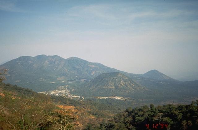
Four peaks of the 40-km-long Sierra Tecapa range rise to the NE above the Pacific coastal plain. On the left is Volcбn Taburete, and in the center is El Tigre volcano. The high peak at the right is Usulutбn, and in the distance at the far right is San Miguel volcano, the highest in eastern El Salvador.Photo by Lee Siebert, 1999 (Smithsonian Institution) http://www.volcano.si.edu/world/volcano.cfm?vnum=1403-072&volpage=photos |
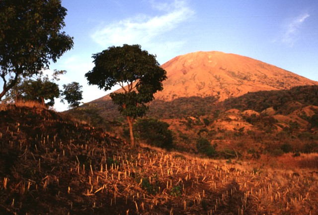
Usulutan is a stratovolcano in central El Salvador, rising above the coastal plain between the San Vicente and San Miguel volcanoes, and just east of Taburete volcano. The volcano is topped by a 1.3 km wide summit crater which is breached to the east.Usulutan volcano, 1449, anchors the SE end of a cluster of basaltic to basaltic-andesite stratovolcanoes between San Vicente and San Miguel volcanoes. The flanks of the forested Usulutan volcano are dissected, but youthful lava flows are present on its southern flanks. The younger summit rocks of 1449-m-high Usulutбn and Cerro Nanzal pyroclastic cone on the lower SE flank were mapped as Holocene (Weber and Wiesemann, 1978). A broad 1.3-km-wide crater is breached to the east from the summit of Usulutбn to its lower flank. Usulutan volcano (right), at the SE end of a cluster of stratovolcanoes west of San Miguel volcano, has an eroded summit crater, but youthful flows are present on its southern flanks. La Manita (left) a small cone to the NE of Usulutan on the flank of El Tigre volcano has also been mapped as Holocene in age, along with Cerro Nanzal, a pyroclastic cone on the SE flank of Usulutan. No historical eruptions are known from Usulutn. Cerro Oromontique, the small peak on the left horizon, was erupted along a fissure cutting the flank of El Tigre volcano. Relatively young lava flows are located on the southern flank of Usulutan volcano http://www.volcano.si.edu/world/volcano.cfm?vnum=1403-081&volpage=photos |
A large erosional valley 1.3 km wide at its head cuts the eastern flank of the basaltic to basaltic-andesite Usulutan volcano. It is seen here from the flanks of Chinameca volcano to its NE with the Pacific Ocean in the distance at the left. Despite its prominence, Usulutan volcano has not been studied in detail. Photo by Carlos Pullinger, 1996 (Servicio Nacional de Estudios Territoriales, El Salvador).http://www.volcano.si.edu/world/volcano.cfm?vnum=1403-081&volpage=photos |
A westward view down the axis of a cluster of volcanoes between San Miguel and San Vicente volcanoes shows the eroded Pleistocene Cerro el Tigre volcano at the left and flat-topped Tecapa volcano to its right. San Vicente volcano can be seen in the far right distance.Photo by Carlos Pullinger, 1996 (Servicio Nacional de Estudios Territoriales, El Salvador).http://www.volcano.si.edu/world/volcano.cfm?vnum=1403-082&volpage=photos |
Heavily forested Cerro el Tigre is the NE-most and oldest of the cluster of coalescing Quaternary volcanoes between the Rнo Lempa and San Miguel volcano. The Pleistocene volcano is seen here from Chinameca volcano to its east, with Usulutбn volcano in the shadow at the left. The low cone in the sun in front of Usulutan is Cerro la Manita, a Holocene cone constructed along a NW-SE-trending fissure cutting the flanks of El Tigre.Photo by Carlos Pullinger, 1996 (Servicio Nacional de Estudios Territoriales, El Salvador).http://www.volcano.si.edu/world/volcano.cfm?vnum=1403-082&volpage=photos |
The dissected Pleistocene volcano El Tigre is seen here from the NW on the flanks of Tecapa volcano with the town of Santiago de Maria at the left center. Two Holocene cones, symmetrical Cerro Oromontique in the center of the photo and Cerro la Manita, the small peak on the right horizon, were erupted along a NW-SE-trending fissure cutting the flanks of El Tigre volcano. Photo by Kristal Dorion, 1994 (U.S. Geological Survey). Caption: GVP.Cerro el Tigre, 1640m, Holocene stratovolcano is the highest, NE-most, and oldest of the cluster of coalescing basaltic to basaltic-andesite Quaternary volcanoes between the Rio Lempa and San Miguel volcano. The summit crater of El Tigre has been destroyed by erosion, and the flanks of the volcano are deeply dissected. Two large NNW-trending valleys, parallel to other regional fissures, cross the volcano, which lies about 7 km SE of Tecapa volcano and a similar distance NE of Usulutбn volcano. Although El Tigre itself is Pleistocene in age, two young cones on its flanks were mapped as Holocene by Weber and Wiesemann (1978). Cerro Oromontique and Cerro la Manita were erupted on the western and southern flanks of El Tigre, respectively, along a NW-SE-trending fissure extending towards Tecapa volcano. Last eruption unknown. http://www.volcano.si.edu/world/volcano.cfm?vnum=1403-082&volpage=photos http://feww.wordpress.com/2010/04/26/a-family-photo-of-volcanoes-el-salvador/ |
Tecapa |
Tecapa, 1593, Holocene is a complex basaltic-to-andesitic stratovolcano at the NW end of a cluster of volcanoes east of the Rнo Lempa between San Vicente and San Miguel volcanoes. The Berlin caldera, whose rim is visible on the west side of the complex, was formed during the eruption of the Blanca-Rosa dacitic pumice in the late Pleistocene. Following caldera formation the cones of Cerro Las Palmas, Cerro Pelуn, Tecapa-Laguna de Alegria, and Cerro Alegria were constructed along a WSW-ENE line. The crater of Tecapa-Laguna de Alegria contains a deep notch on the eastern rim and is filled by Laguna de Alegria crater lake. The Tecapa volcanic complex currently displays fumarolic activity, and a producing geothermal plant is located at the Berlin geothermal field. http://www.volcano.si.edu/world/volcano.cfm?vnum=1403-08=&volpage=photos |
Laguna de Alegria is seen here from the summit of Tecapa volcano, looking SE with the town of Santiago de Maria in the background. The 600-m-wide crater lake lies about 300 m below the summit. Santiago de Maria is situated at the eastern end of the Tecapa volcanic complex, on the 900-m-high saddle between it and Cerro El Tigre volcano. The slopes of the young cone of Cerro Oromontique, constructed on the flank of El Tigre volcano along a NW-SE-trending fissure between Tecapa and El Tigre, rise immediately to the right of the town.Photo by Carlos Pullinger, 1994 (Servicio Nacional de Estudios Territoriales, El Salvador). http://www.volcano.si.edu/world/volcano.cfm?vnum=1403-08=&volpage=photos |
The peak of Loma San Juan (left-center) lies along the northern crater rim of Laguna de Alegrнa, a crater lake at the summit of Tecapa volcano. Solfataras found along the rim of the crater lake have a maximum temperature of 94 degrees Centigrade. An area of hydrothermally altered clay containing up to 45 percent sulfur is found around the crater lake.Photo by Giuseppina Kysar, 1999 (Smithsonian Institution). http://www.volcano.si.edu/world/volcano.cfm?vnum=1403-08=&volpage=photos |
The summit of Tecapa volcano contain a 600-m-wide crater lake, Laguna de Alegria. The 0.9 x 1.3 km wide crater, seen here from the west, is elongated in an E-W direction and lies about 300 m below the summit. Photo by Kristal Dorion, 1994 (U.S. Geological Survey). http://www.volcano.si.edu/world/volcano.cfm?vnum=1403-08=&volpage=photos |
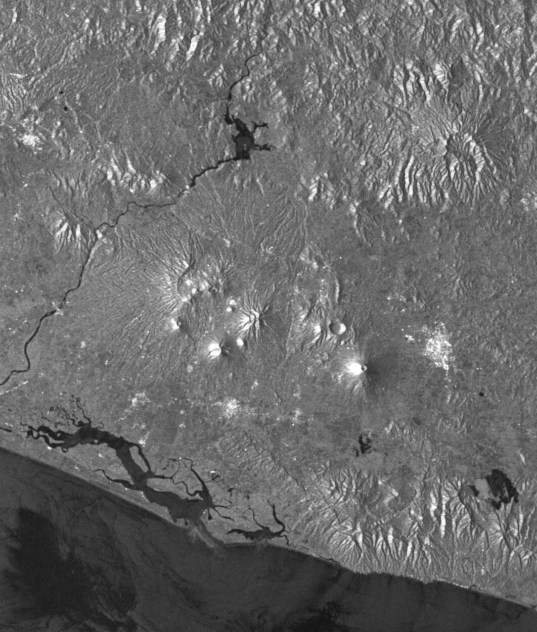
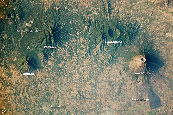
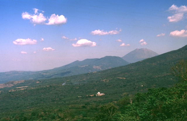
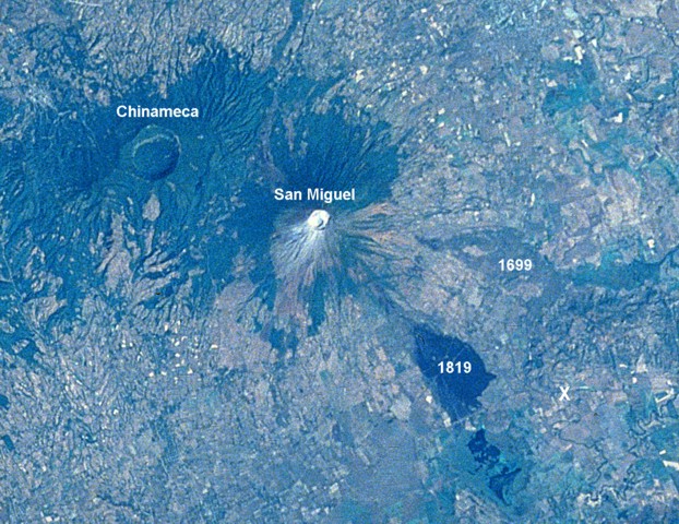
An E-W-trending chain of volcanoes extends ca. 30 km across eastern El Salvador. The small light-colored dot at the left is Laguna de Alegria, a crater of the Tecapa volcanic complex. No historical eruptions are known from the eroded Usulutбn and El Tigre volcanoes. The 2-km-wide Laguna Seca el Pacayal caldera is a prominent feature of Chinameca volcano. San Miguel is one of El Salvador''s most active volcanoes; the dark area at the lower right is a lava flow from the 1819 eruption. The city of San Miguel is at the upper right. Usulutan: Formed during Holocene (an ongoing geological epoch that began about 12,000 years ago). El Tigre formed during the Pleistocene Epoch (2.588 million to about 12,000 years ago). The summit crater of El Tigre has eroded. Chinameca Volcano has a two-km-wide caldera formed after a powerful eruption caused its dome to collapse. San Miguel - the youngest member of the family, is situated about 15 km southwest of the city of San Miguel, where it takes its name from. ItÆs one of the most active volcanoes in el Salvador and last erupted in 2002. (Source of Photo: NASA. Astronaut photograph ISS023-E-22411 was acquired on March 31, 2010).http://feww.wordpress.com/2010/04/26/a-family-photo-of-volcanoes-el-salvador/ |
Chinameca (also known as El Pacayal) is a small stratovolcano in central-eastern El Salvador. It lies north of San Miguel volcano. The volcano is topped by a 2 km wide caldera known as Laguna Seca el Pacayal, and a satellite cone on the west side, Cerro el Limbo, rises higher than the caldera rim. Fumaroles can be found on the north side, and it has been the site of a geothermal exploration program. No eruptions. - http://en.wikipedia.org/wiki/Chinameca_(volcano) .A 2-km-wide, steep-sided caldera truncates the 1300-m-high summit of Chinameca volcano, whose flanks are draped with coffee plantations. The Holocene cone of Cerro el Limbo on the western flank rises to 1380 m, above the level of the caldera rim, and a Holocene lava flow extends from a NNW-flank vent into the lowlands to the north beyond the town of Chinameca (Weber and Weisemann, 1978). A group of fumarole fields is located on the north flank of the volcano surrounds the city of Chinameca, and the volcano has been the site of a geothermal exploration programhttp://www.volcano.si.edu/world/volcano.cfm?vnum=1403-09= |
Chinameca volcano, also known as El Pacayal, is seen here to the NW from the barren upper flanks of San Miguel volcano. The high point of the caldera, Cerro el Pacayal, lies on the western rim (left-center) and rises about 450 m above the caldera floor. The rounded peak of Cerro el Limbo at the left rises to above 1380 m, exceeding the height of the caldera rim. Photo by Lee Siebert, 1999 (Smithsonian Institution).http://www.volcano.si.edu/world/volcano.cfm?vnum=1403-09=&volpage=photos el Limbo is a Holocene flank cone on the western flank A lava flow of Holocene age was also erupted from a NNW-flank vent into the lowlands to the north beyond the town of Chinameca. Fumarole fields are located on the north flank of the volcano and surround the city of Chinameca. 3 strong shallow earthquakes of 5.9, 6.0 and 5.5 magnitude occurred on 6 and 7 May 1951 near the town of Jucuapa at the NW base of Chinameca volcano. http://www.volcanodiscovery.com/chinameca.html |
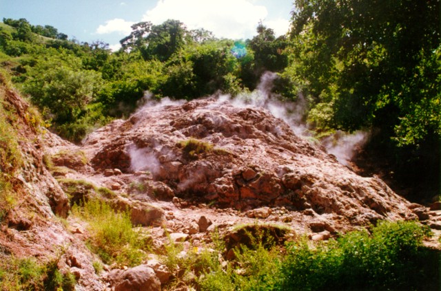
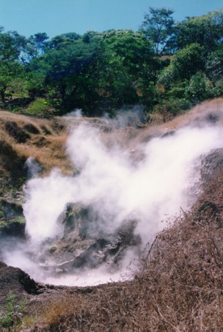
Steam rises from fumaroles in an area of hydrothermally altered rock on the northern flank of Chinameca volcano. Fumarole fields surround the city of Chinameca on several sides within a few kilometers of the town. A geothermal potential of 5-55 MW has been identified at Chinameca.Photo courtesy of Comision Ejecutiva Hidroelectricia del Rio Lempa (CEL).http://www.volcano.si.edu/world/volcano.cfm?vnum=1403-09=&volpage=photos |
Los Infernillos Canton las Meses thermal area at Chinameca volcano features a cluster of mudpots. This is part of a series of fumarole fields surrounding the city of Chinameca.Photo by Carlos Pullinger, 1994 (Servicio Nacional de Estudios Territoriales, El Salvador).http://www.volcano.si.edu/world/volcano.cfm?vnum=1403-09=&volpage=photos |
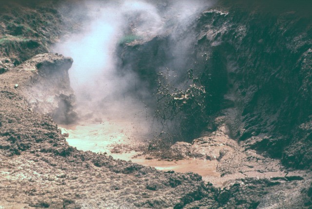
A fumarolic area known as Chinameca 4 is one of several surrounding the city of Chinameca. Temperatures of around 100 degrees Centigrade have been recorded at the fumaroles of Ausoles la Viejona, Ausoles el Boquerуn, and Infiernillos de Chinameca. The high heat flow has made this area the object of geothermal exploration.Photo courtesy of Comision Ejecutiva Hidroelectricia del Rio Lempa (CEL). http://www.volcano.si.edu/world/volcano.cfm?vnum=1403-09=&volpage=photos |
The Chinameca volcanic complex on the center horizon is seen here from the west beyond the low-angle slopes of the Pleistocene El Tigre volcano in the foreground. The low, flat-topped peak at the right side of the Chinameca complex is Cerro el Limbo, a cone on the western flank of Chinameca caldera. The high conical peak at the upper right is San Miguel volcano, which is separated by a low saddle from Chinameca.Photo by Carlos Pullinger, 1994 (Servicio Nacional de Estudios Territoriales, El Salvador) http://www.volcano.si.edu/world/volcano.cfm?vnum=1403-10=&volpage=photos |
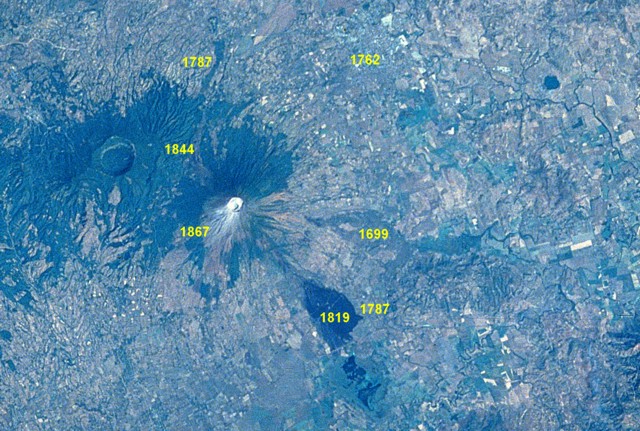
A large eruption took place from San Miguel in 1699, accompanied by strong earthquakes, flames, and rumblings. A major lava flow (right-center) traveled from SE-flank fissures for a straight-line distance of nearly 9 km. The flow divided around a light-colored kipuka and then banked against Pleistocene volcanic hills, where it was deflected to the south in a narrow lobe to the point labeled "X." The 2.5-km-wide caldera of Chinameca volcano lies across a saddle from San Miguel in this Space Shuttle image with north to the upper left. NASA Space Shuttle image STS61C-31-47, 1986 (http://eol.jsc.nasa.gov/). |
Conical San Miguel volcano, one of El Salvador''s most prominent landmarks, rises across a low saddle SE of Chinameca (Pacayal) volcano. The 2130-m-high San Miguel is seen here from Cerro el Limbo, a cone on the western flank of Chinameca. The southern side of Chinameca''s 2-km-wide summit caldera is visible at the left.Photo by Carlos Pullinger, 1996 (Servicio Nacional de Estudios Territoriales, El Salvador). http://www.volcano.si.edu/world/volcano.cfm?vnum=1403-10=&volpage=photos |
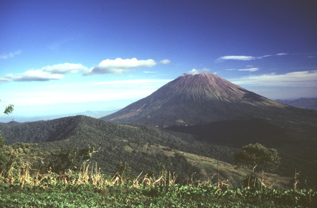
The SW side of San Miguel volcano towers more than 2000 m above the Pacific coastal plain; the base of the volcano lies only about 100 m above sea level. The symmetrical volcano is one of the most active in El Salvador and has produced dominantly basaltic and basaltic andesite lava flows and tephra. Frequent eruptions have kept much of the upper part of the edifice unvegetated. Flank vents are concentrated on the SE and NW quadrants of the volcano, but have been active during historical time on all sides.Photo by Lee Siebert, 1999 (Smithsonian Institution).http://www.volcano.si.edu/world/volcano.cfm?vnum=1403-10=&volpage=photos |
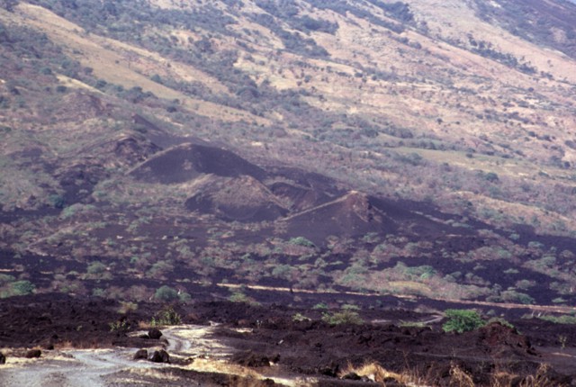
The symmetrical cone of San Miguel volcano, last eruption 2002, one of the most active in El Salvador, rises from near sea level to form one of the country''s most prominent landmarks. The unvegetated summit of the 2130-m-high volcano rises above slopes draped with coffee plantations. A broad, deep crater complex that has been frequently modified by historical eruptions (recorded since the early 16th century) caps the truncated summit of the towering volcano, which is also known locally as Chaparrastique. Radial fissures on the flanks of the basaltic-andesitic volcano have fed a series of historical lava flows, including several erupted during the 17th-19th centuries that reached beyond the base of the volcano on the north, NE, and SE sides. The SE-flank lava flows are the largest and form broad, sparsely vegetated lava fields crossed by highways and a railroad skirting the base of the volcano. The location of flank vents has migrated higher on the edifice during historical time, and the most recent activity has consisted of minor ash eruptions from the summit crater.This sparsely vegetated basaltic lava flow was erupted from a fissure vent on the lower SE flank of San Miguel in 1819. The flow covers a broad 2.5-km-wide, 5-km-long area on the low-angle slopes below the volcano and reaches down to an elevation of less than 40 m above sea level. The principal coastal highway of El Salvador traverses the flow below the point of this photo, and the national railway crosses the flow closer to the vent.Photo by Lee Siebert, 1999 (Smithsonian Institution). http://www.volcano.si.edu/world/volcano.cfm?vnum=1403-10=&volpage=photos |
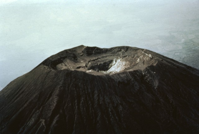
The summit of San Miguel volcano was reported to be peaked prior to the 16th century, but now is truncated by a 1-km-wide crater. This aerial view shows the 2130 m high point on the far NE crater rim in the center of the photo and several benches cut by a roughly 250-m-deep central crater. The morphology of the crater has varied greatly during historical time as a result of the creation and subsequent destruction of new craters. A cinder cone that formed in the NE part of the crater in 1884 had disappeared 50 years later. Photo by Willard Parsons, 1964 (courtesy of Bill Rose, Michigan Technological University). http://www.volcano.si.edu/world/volcano.cfm?vnum=1403-10=&volpage=photos |
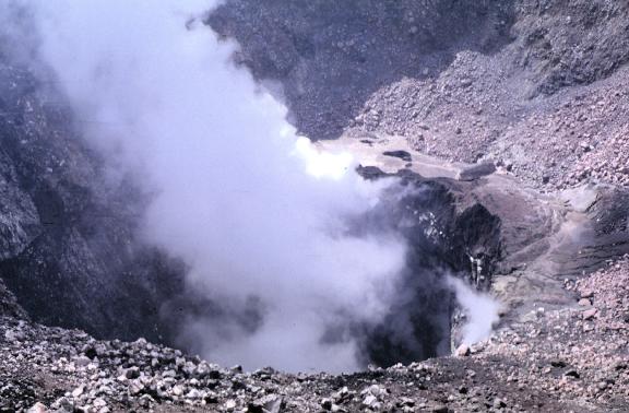
View of the internal crater of San Miguel volcano. High temperature fumaroles periodically cause small phreatic eruptions that deposit thin layers of ash on the surrounding vegetation. Photo by Carlos Pullinger, 1994http://www.geo.mtu.edu/volcanoes/central_america/el_salvador/san_miguel/images/ |
The summit crater of San Miguel volcano reflects a complex sequence of events. This view from the northern crater rim shows two lava benches that are truncated by a deep compound central pit crater from which steam plumes rise. The morphology of the summit crater has varied dramatically during historical time. The inner pit crater has gradually expanded to the east and north and increased in depth to nearly 350 m in 1999.Photo by Lee Siebert, 1999 (Smithsonian Institution). http://www.volcano.si.edu/world/volcano.cfm?vnum=1403-10=&volpage=photos |
This view from the southern crater rim shows the 2030 m high point of San Miguel on the NE rim at the upper right. An ejecta-covered terrace on the eastern side of the crater is truncated by a deep inner crater. The crater morphology has varied dramatically since the beginning of documentation in the 16th century. In 1866 a 600-m-wide, 320-m-deep crater existed in the SE part of the summit crater, while a 100-m-wide, 80-m-deep adventive crater was located in its ENE part.Photo by Lee Siebert, 1999 (Smithsonian Institution) http://www.volcano.si.edu/world/volcano.cfm?vnum=1403-10=&volpage=photos |
The summit of San Miguel volcano contains a deep crater whose morphology has been frequently modified by historical eruptions. In 1586 the volcano already had a truncated summit; before then the volcano was said to have had a sharp peak. In 1866 the crater was 600 m wide and 320 m deep and contained a subcrater on the ENE side. A cinder cone that formed at the NE side of the crater in 1884 had largely disappeared by 1924, and a ring plain on the crater floor was largely gone by 1949.Copyrighted photo by Dick Stoiber, 1965 (Dartmouth College). http://www.volcano.si.edu/world/volcano.cfm?vnum=1403-10=&volpage=photos |
A deep crater that has been frequently modified by historical eruptions (recorded since the early 16th century) caps the truncated summit of the basaltic-to-andesitic volcano. Radial fissures on its flanks have fed a series of fresh lava flows. This barren lava flow issued from a fissure vent on the SE flank of San Miguel in 1819. The flow traveled about 5 km and covered a broad area below the SE base of the volcano, extending down to 25 m above sea level. Emplacement of the lava flow necessitated the construction of a new road at the base of the volcano.Photo by Dick Stoiber, 1971 (courtesy of Bill Rose, Michigan Technological University). http://www.volcano.si.edu/world/volcano.cfm?vnum=1403-10=&volpage=photos The basaltic lava flow in the foreground originated during a major effusive eruption that began from fissure vents on the NNW flank of San Miguel on July 25, 1844. By December lava was confined to the crater. The volcano then entered a several-year-long period of explosive activity. Another lava flow was reported in 1848, the year the eruption ended.Photo by Paul Kimberly, 1999 (Smithsonian Institution). http://www.volcano.si.edu/world/volcano.cfm?vnum=1403-10=&volpage=photos |
The dark sparsely vegetated area in the center of the photo marks basaltic lava flows erupted on the SE flank of San Miguel volcano in 1819. The flows, seen here from the summit of San Miguel, originated from fissure vents on the lower SE flank in July 1819 and traveled about 5 km downslope toward Laguna el Jocotal (upper right). The small lava flows at the lower right-center were erupted in December 1855. The principal coastal highway and the national railway of El Salvador cross the 1819 flows.Photo by Lee Siebert, 1999 (Smithsonian Institution). http://www.volcano.si.edu/world/volcano.cfm?vnum=1403-10=&volpage=photos |
The sparsely vegetated basaltic lava flow cutting diagonally across the photo to the upper right was erupted from a NNW-flank vent in 1844. The flow traveled initially to the NNW toward the broad saddle between San Miguel and Chinameca volcanoes and then was deflected to the NE. It traveled in a narrow lobe as far as 8 km from the summit near the path of the present-day road between the town of San Jorge and the city of San Miguel.Photo by Lee Siebert, 1999 (Smithsonian Institution). http://www.volcano.si.edu/world/volcano.cfm?vnum=1403-10=&volpage=photos |
The fresh-looking lava flow at the upper right on the north flank of San Miguel volcano was emplaced during an eruption in 1844. The flow originated on July 25 from a NNW-flank fissure and traveled initially to the NNW before diverting to the NE and reaching to 8 km from the summit. After December the volcano began long-term explosive activity that lasted until 1848, when another lava flow occurred.Photo by Kristal Dorion, 1994 (U.S. Geological Survey). http://www.volcano.si.edu/world/volcano.cfm?vnum=1403-10=&volpage=photos |
This large lava bomb in the summit crater of San Miguel was probably erupted in 1976. Lava fountaining took place in the central crater, which was active December 2-12, 1976 and February 28 to March 1, 1977, constructing a new spatter cone. Ashfall in December 1976 caused some crop damage. Photo by Carlos Pullinger, 1996 (Servicio Nacional de Estudios Territoriales, El Salvador).http://www.volcano.si.edu/world/volcano.cfm?vnum=1403-10=&volpage=photos |
Small cinder cones on the lower SE flank of San Miguel between about 300 and 400 m altitude were constructed along a radial fissure that also was the source of a voluminous basaltic lava flow (foreground) erupted in 1819. The flow traveled about 5 km and covered a broad area below the base of the volcano.Photo by Paul Kimberly, 1999 (Smithsonian Institution).http://www.volcano.si.edu/world/volcano.cfm?vnum=1403-10=&volpage=photos |
The low ridge in the left foreground is the vegetation-covered surface of a SW-flank lava flow erupted in 1867. Lava effusion began on the SW flank on December 14. Explosive activity continued, producing ashfall over the city of Usulutßn (20 km to the SW) and damaging tobacco plantations. The volcano was reported to be in activity again on February 2 and was particularly active on February 16. Lava fountains produced extensive scoria deposits that mantled the flow, causing it to be more vegetated than older flows.Photo by Lee Siebert, 1999 (Smithsonian Institution). http://www.volcano.si.edu/world/volcano.cfm?vnum=1403-10=&volpage=photos |
http://www.geo.mtu.edu/volcanoes/central_america/el_salvador/san_miguel/ |
An eruption at San Miguel on September 21-23, 1787 from summit and N- and SE-flank vents produced five lava flows. Ashfall caused extensive crop damage. Other historical lava flows from San Miguel are labeled in this Space Shuttle image with north to the upper left. The 1762 lava flow (faintly seen at the upper right) extended as far as the present-day city of San Miguel. The 2.5-km-wide caldera of Chinameca volcano lies NW of San Miguel volcano, and the small dark-colored dot at the upper right is Laguna de Aramuaca maar. NASA Space Shuttle image STS61C-31-47, 1986 (http://eol.jsc.nasa.gov/). |
Laguna Aramuaca |
Laguna Aramuaca, maar, Holocene, last eruption unknown. A solitary, 1-km-wide, lake-filled maar, Laguna Aramuaca, occupies a low-lying area about 10 km SE of the city of San Miguel. The Pan-American highway swings around the south side of the maar immediately north of the Rio Grande de San Miguel. Laguna Aramuaca was mapped as Holocene by Weber and Wiesemann (1978), but has not been studied in detail. The low rim of the maar rises about 50-100 m above the countryside and reaches only 181 m above sea level. Spectacular pyroclastic-surge deposits are exposed by quarries near the rim of the maar. The low SW rim of Aramuaca maar is reflected in the waters of 600-m-wide Laguna de Aramuaca. The maar was erupted through sediments in a plain north of the Rнo Grande de San Miguel. http://www.volcano.si.edu/world/volcano.cfm?vnum=1403-101&volpage=photos |
|
A quarry at Laguna de Aramuaca exposes a roughly 10-m-high section of thinly bedded pyroclastic-surge layers. Despite its immediate proximity to the Pan-American highway, this spectacular maar remains to be studied in detail.Photo by Lee Siebert, 1999 (Smithsonian Institution). http://www.volcano.si.edu/world/volcano.cfm?vnum=1403-101&volpage=photos |
Bedded pyroclastic-surge deposits are exposed in a quarry at Laguna de Aramuaca, SE of the city of San Miguel. Conical San Miguel volcano rises 18 km to the west in the right background. Note the person in the center for scale.Photo by Giuseppina Kysar, 1999 (Smithsonian Institution).http://www.volcano.si.edu/world/volcano.cfm?vnum=1403-101&volpage=photos |


Home http://plate-tectonic.narod.ru/volcanoam13aphotoalbum.html
http://en.wikipedia.org/wiki/List_of_volcanoes_in_El_Salvador
http://en.wikipedia.org/wiki/List_of_volcanoes_in_Honduras
http://en.wikipedia.org/wiki/List_of_volcanoes_in_Nicaragua
http://en.wikipedia.org/wiki/List_of_volcanoes_in_Panama
http://en.wikipedia.org/wiki/List_of_volcanoes_in_Costa_Rica
South CAVA
El Salvador volcanoes
Apastepeque Volcanic Field
http://en.wikipedia.org/wiki/List_of_volcanoes_in_El_Salvador