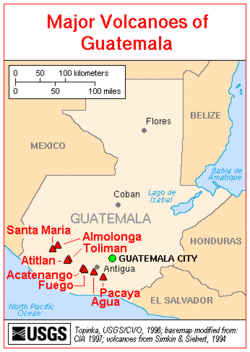
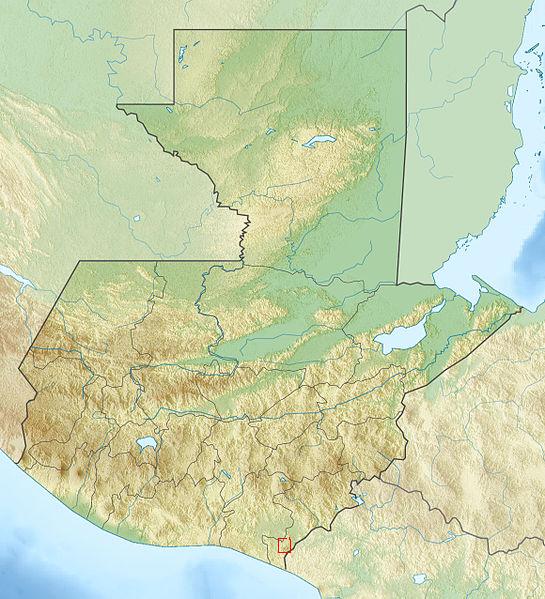
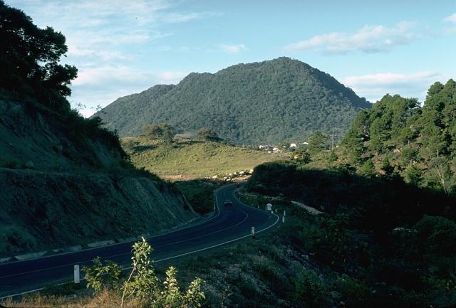
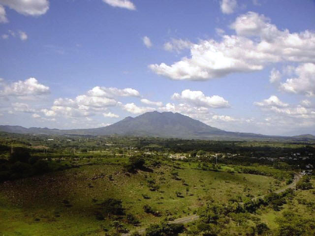
 | Cava, southern Guatemala |
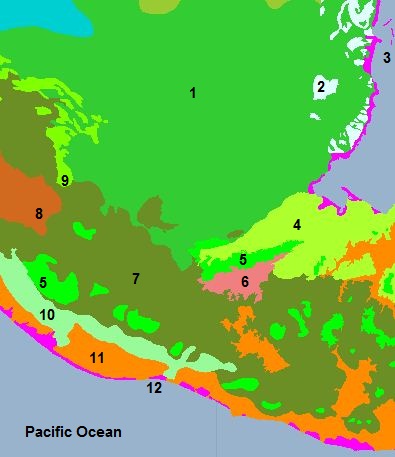
Ecology and biodiversity: 1. Penten-Veraruz moist forests covers most of northern Guatemala 2. A patch of the Belizian pine forests ecoregion is located in northeast Guatemala.3. Mesoamerican Gulf-Caribbean mangroves (Petenes mangroves - Northern Honduras mangroves) 4. Central American Atlantic moist forest 5. Central American montane forests 6. . One of the driest areas in Central America, the Motagua Valley area, is the location of the Motagua Valley thornscrub7. The Central American pine-oak forests ecoregion spans southern Guatemala.8. Along the border with Mexico lies the Chiapas Depression dry forests.9. Chiapas montane forests 10. Sierra Madre de Chiapas moist forest 11. Central American dry forests 12. Southern Mesoamerican Pacific Mangroves (Tehuantepec-El Manchon mangroves - Northern Dry Pacific Coast mangroves) http://www.eoearth.org/article/Guatemala |
|
|
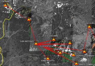
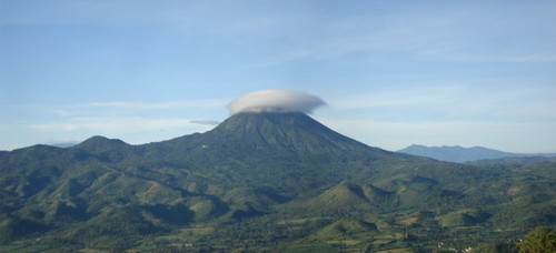
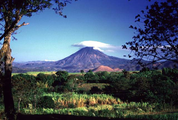
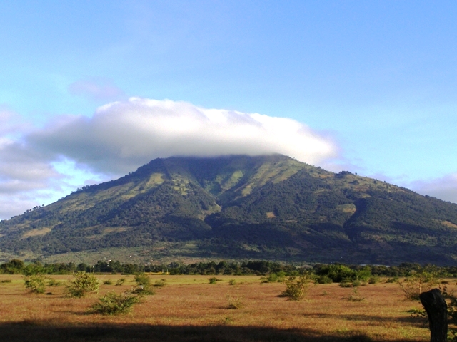
Volcano Siete Orejas near volcano santa Maria http://en.wikipedia.org/wiki/Volc%C3%A1n_Siete_Orejas |
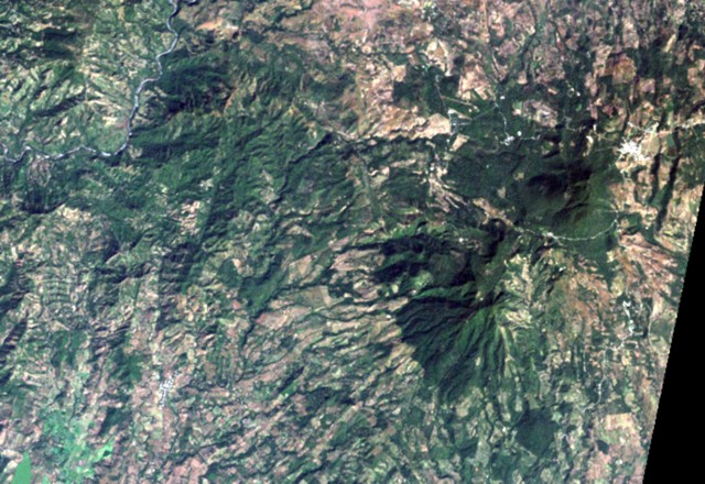
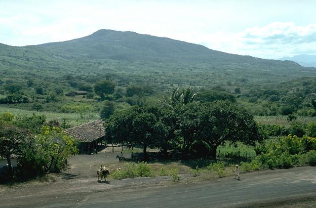
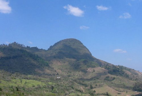
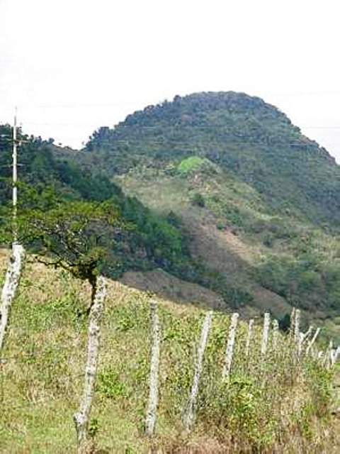
Cerro de Coxom is a stratovolcano in western Guatemala. The 3,045-m |
|
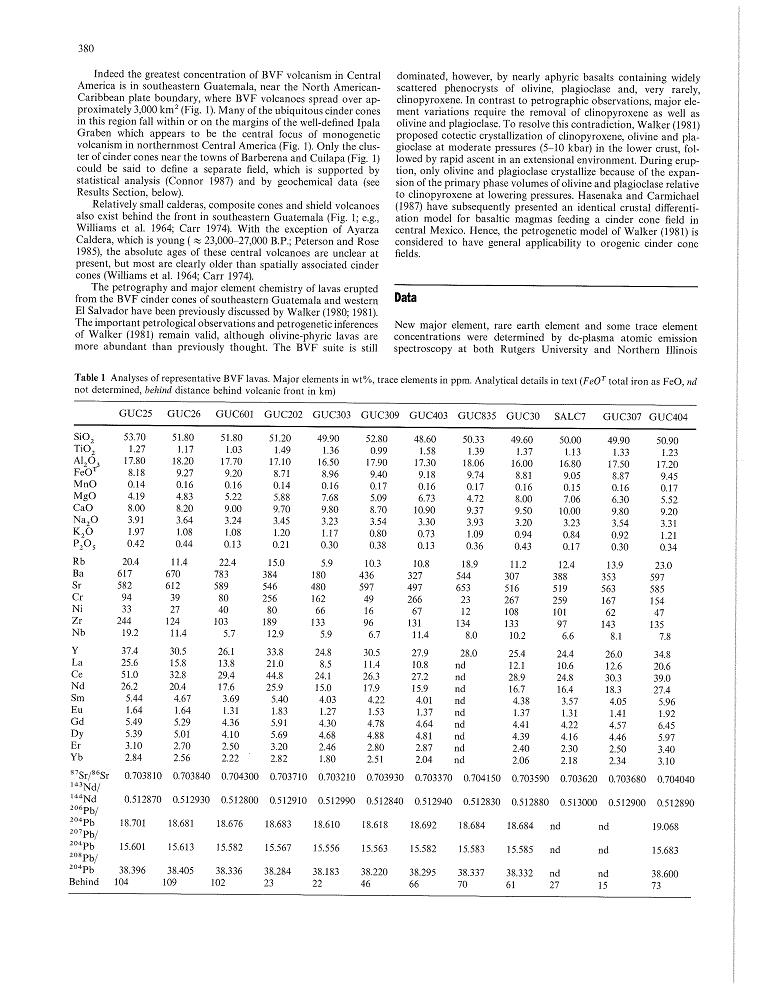
Cuilapa-Barbarena volcanic field 14.33 N, 90.40 W, summit elevation 1454 m, is located at an intersection between the Jalpatagua fault and Santa Rosa de Lima caldera. Cuilapa-Barbarenca cinder cone field contains 70 monogenetic olivine basalt cones, which are mostly less than 100 m high. Most of the cones are located on the southern and western rims of the Santa Rosa de Lima caldera. Eruptions have occurred within the past few thousand years http://www.volcanolive.com/guatemala.html http://www.geology.wisc.edu/~unstable/PDF/Walker_et_al_1995_CMP.pdf Edifice-collapse phenomena have, to date, received relatively little attention in Central America, although ∼40 major collapse events from about two dozen volcanoes are known or inferred in this volcanic arc. Volcanoes subjected to gravitational failure are concentrated at the arc''s western and eastern ends. Failures correlate positively with volcano elevation, substrate elevation, edifice height, volcano volume, and crustal thickness and inversely with slab descent angle. Collapse orientations are strongly influenced by the direction of slope of the underlying basement, and hence are predominately perpendicular to the arc (preferentially to the south) at its extremities and display more variable failure directions in the center of the arc. The frequency of collapse events in Central America is poorly constrained because of the lack of precise dating of deposits, but a collapse interval of ∼1000–2000 yr has been estimated during the Holocene. These high-impact events fortunately occur at low frequency, but the proximity of many Central American volcanoes to highly populated regions, including some of the region''s largest cities, requires evaluation of their hazards. The primary risks are from extremely mobile debris avalanches and associated lahars, which in Central America have impacted now-populated areas up to ∼50 km from a source volcano. Lower probability risks associated with volcanic edifice collapse derive from laterally directed explosions and tsunamis. The principal hazards of the latter here result from potential impact of debris avalanches into natural or man-made lakes. Much work remains on identifying and describing debris-avalanche deposits in Central America. The identification of potential collapse sites and assessing and monitoring the stability of intact volcanoes is a major challenge for the next decade. http://specialpapers.gsapubs.org/content/412/1.abstract The Cuilapa-Barbarena volcanic field contains approximately 70 Quaternary cinder cones, generally less than 100 m high. Many of the mostly basaltic cones are located along the strike of the major regional Jalpatagua fault, which extends SE from Guatemala City, north of the chain of stratovolcanoes stretching across Guatemala. The cones were erupted from fracture systems related to the intersection of the Jalpatagua fault with the southern and western margins of the Miocene Santa Rosa de Lima caldera and overlie pyroclastic-flow deposits from Amatitlбn caldera to the NW. The age of the most recent eruptions is not known, although the youngest cones post-date the last phase of eruptive activity at Tecuamburro volcano and could be of Holocene age (Reynolds, 1987). Williams (1960) considered the most recent eruptions from the Cuilapa-Barbarena volcanic field to have occurred within the last few thousand years |
The Cuilapa-Barbarena volcanic field contains approximately 70 Quaternary cinder cones, generally less than 100 m high. Many of the mostly basaltic cones are located along the strike of the major regional Jalpatagua fault, which extends SE from Guatemala City, north of the chain of stratovolcanoes stretching across Guatemala. The cones were erupted from fracture systems related to the intersection of the Jalpatagua fault with the southern and western margins of the Miocene Santa Rosa de Lima caldera and overlie pyroclastic-flow deposits from Amatitlбn caldera to the NW. The age of the most recent eruptions is not known, although the youngest cones post-date the last phase of eruptive activity at Tecuamburro volcano and could be of Holocene age (Reynolds, 1987). Williams (1960) considered the most recent eruptions from the Cuilapa-Barbarena volcanic field to have occurred within the last few thousand years |
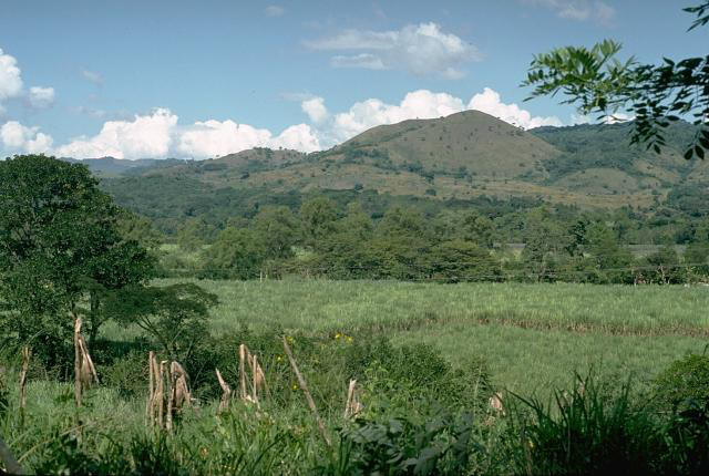
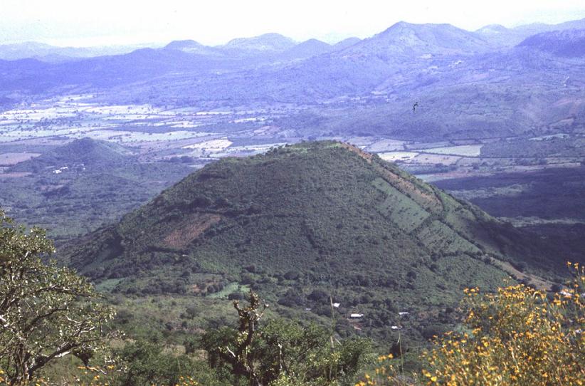
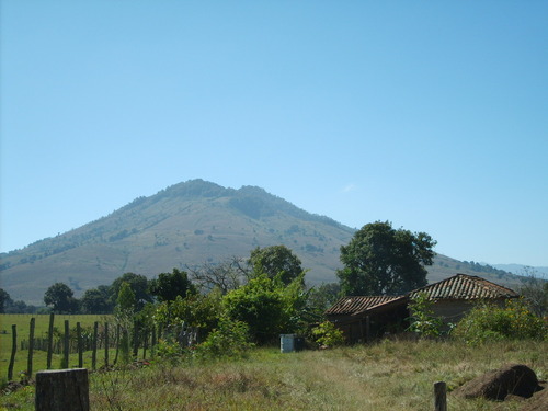
Nearly 50 Pleistocene-Holocene cinder cones comprise the Barbarena-Cuilapa cinder cone field. The field apparently originated due to tensional faulting where the Jalpatagua Fault bends around the southern margin of the Santa Rosa de Lima caldera. The cones tend to align along the faults. A few of the cones south of Cuilapa are seen in the middle distance - http://www2.brevard.edu/reynoljh/centralamerica/southcentralguat.htm |
Pleistocene basalt flow, from one of the nearby cinder cones in the Cuilapa area, filled an old valley and formed columnar joints as it cooled. The flow was subsequently faulted and cut through by the Rio Los Esclavos, seen at the canyon bottom.- http://www2.brevard.edu/reynoljh/centralamerica/southcentralguat.htm |
volcano Jumaytepeque.Jumaytepeque volcano straddles the southeastern rim of the Santa Rosa de Lima caldera. This photo was taken from the southern edge of the resurgent dome and looks southeastward across the caldera floor with the town of Nueva Santa Rosa in the center. The caldera was a lake until it was filled with pumice from the Ayarza eruption about 20,000 years ago.This area was a caldera -http://www2.brevard.edu/reynoljh/centralamerica/southcentralguat.htm Jumaytepeque Volcano 14.336 N, 90.269 W , summit elevation 1815 m , cinder cones north of the NW-SE-trending Jalpatagua fault.The volcano sits near the SE rim of the large Miocene Santa Rosa de Lima calderahttp://www.volcanolive.com/guatemala.html |
Tecuamburro volcano. Tecuamburro is an andesitic stratovolcano which formed 38 KA inside a horseshoe-shaped caldera formed by a structural failure in a second, 100,000-year-old stratovolcano, known as Miraflores. At the top of the Tecuamburro is an acidic crater lake around which many hot springs, fumaroles, and boiling mudpots are found |
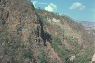
The Rio los Esclavos drains the eastern portion of the south-central Guatemala area. Deciphering the superposition of the interfingering strata exposed along its banks, with the help of a few key isotopic ages, were critical to unraveling the geologic history of the area. In this photo, the river has cut through a thick bed of pumicious rhyolite that was erupted from Tecuamburro volcano between 20-30 KA. Tecuamburro is on the southern boundary of the Cuilapa quadrangle. The flow completely filled in the prexisting canyon and formed a small lake that stretched upstream until the river reestablished its path through the easily-eroded pumice. You can see Carl (red hat) in the lower right, for scale. The white dot at the lower right base of the cliff, above Carl''s head, is a local fisherman. The base of the pumice rests on top of Pliocene andesitic lavas from Ixhuatan volcano http://www2.brevard.edu/reynoljh/centralamerica/southcentralguat.htm |
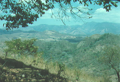
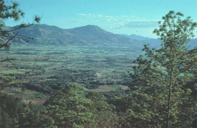
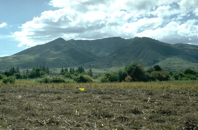
This image shows most of the southern two thirds of the Dartmouth map area in south-central Guatemala. The mountains on the left are the extinct Ixhuatan volcano. Those on the right are Tecuamburro volcano. With just a little imagination, the Pacific Ocean can be seen between the two volcanoes stretching to the horizon. The Santa Rosa de Lima caldera lies between the point the low range of hills in the center- http://www2.brevard.edu/reynoljh/centralamerica/southcentralguat.htm |
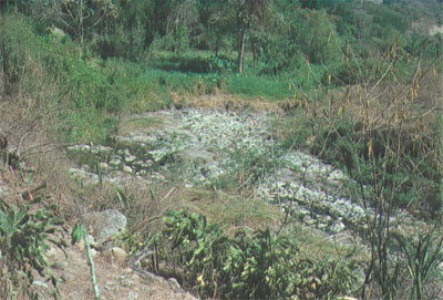
Numerous hot springs are present along the Rio Los Esclavos where it cuts between Ixhuatan and Tecuamburro volcanoes. We measured temperatures over 90є C, suggesting that boiling water, suitable for geothermal energy, was not far below. An odd thing about this site is that there is a local cemetery just out of the picture on the left. http://www2.brevard.edu/reynoljh/centralamerica/southcentralguat.htm |
The rugged jumble of steep hills around the town of Santa Maria Ixhuatan, as seen from the coastal plain to the south. The hills were a collapsed Pliocene andesitic shield volcano that had had a late phase of dacitic dome activity the volcano Ixhuatan. http://www2.brevard.edu/reynoljh/centralamerica/southcentralguat.htm |
This image shows much of the southeastern portion of the Cuilapa quadrangle. The hill on the left is probably some sort of andesitic dome. We never really did figure that one out. The area back in the clouds is the collapsed Ixhuatan volcano. The Rio Los Esclavos canyon lies just in front of the low hill in the center. It is about 100 m deep and is incised through Pleistocene-Holocene basalt flows and Pliocene andesites. The canyon is there because a splay of the right-lateral Jalpatagua Fault cuts the volcanic strata - http://www2.brevard.edu/reynoljh/centralamerica/southcentralguat.htm |
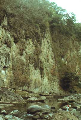
The Pliocene andesite cliffs along the Rio Los Esclavos |
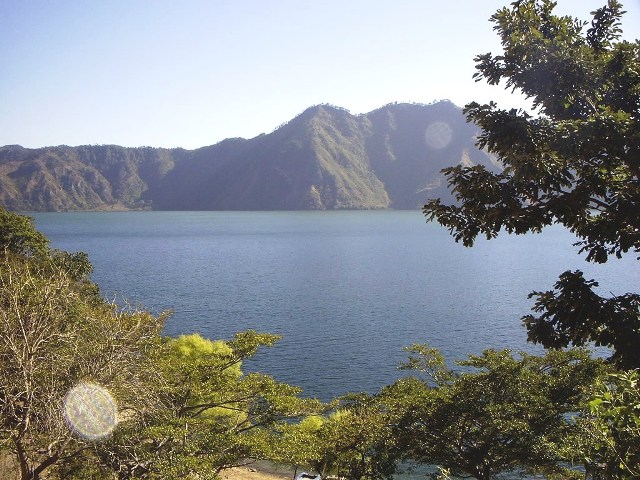
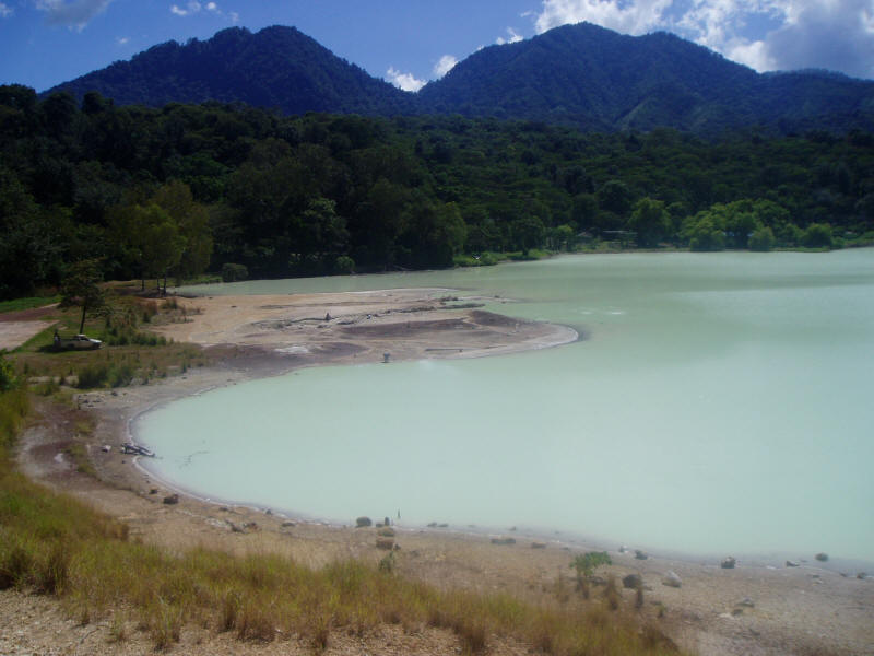
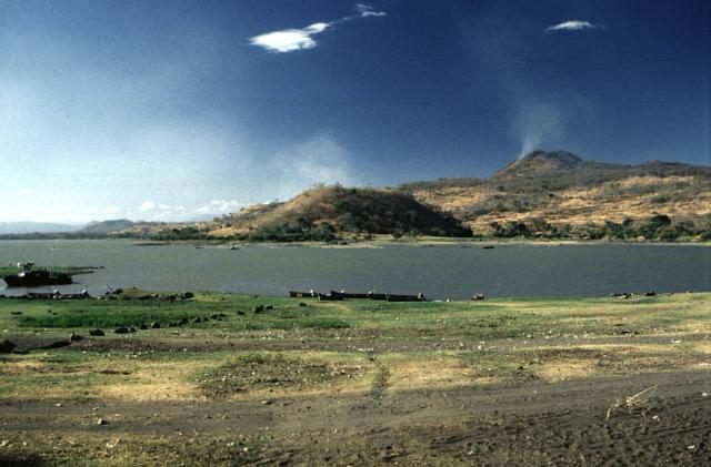
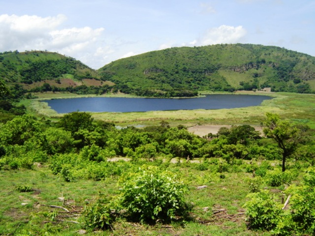
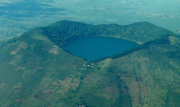
Laguna de Ayarza is a crater lake,s a caldera that was created some 20 KA by a catastrophic eruption that destroyed a twinned volcano and blanketed the entire region with a layer of pumice, destroying a twinned volcano. Pumice from the eruption blanketed the entire region. The mountain in the background is the northern rim of the Santa Rosa de Lima caldera in the Dartmouth map area. Lake Ayarza is situated in the quadrangle to the east of the Nueva Santa Rosa quad. The lake has a surface elevation of 1409 m. |
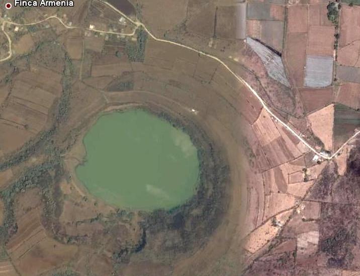
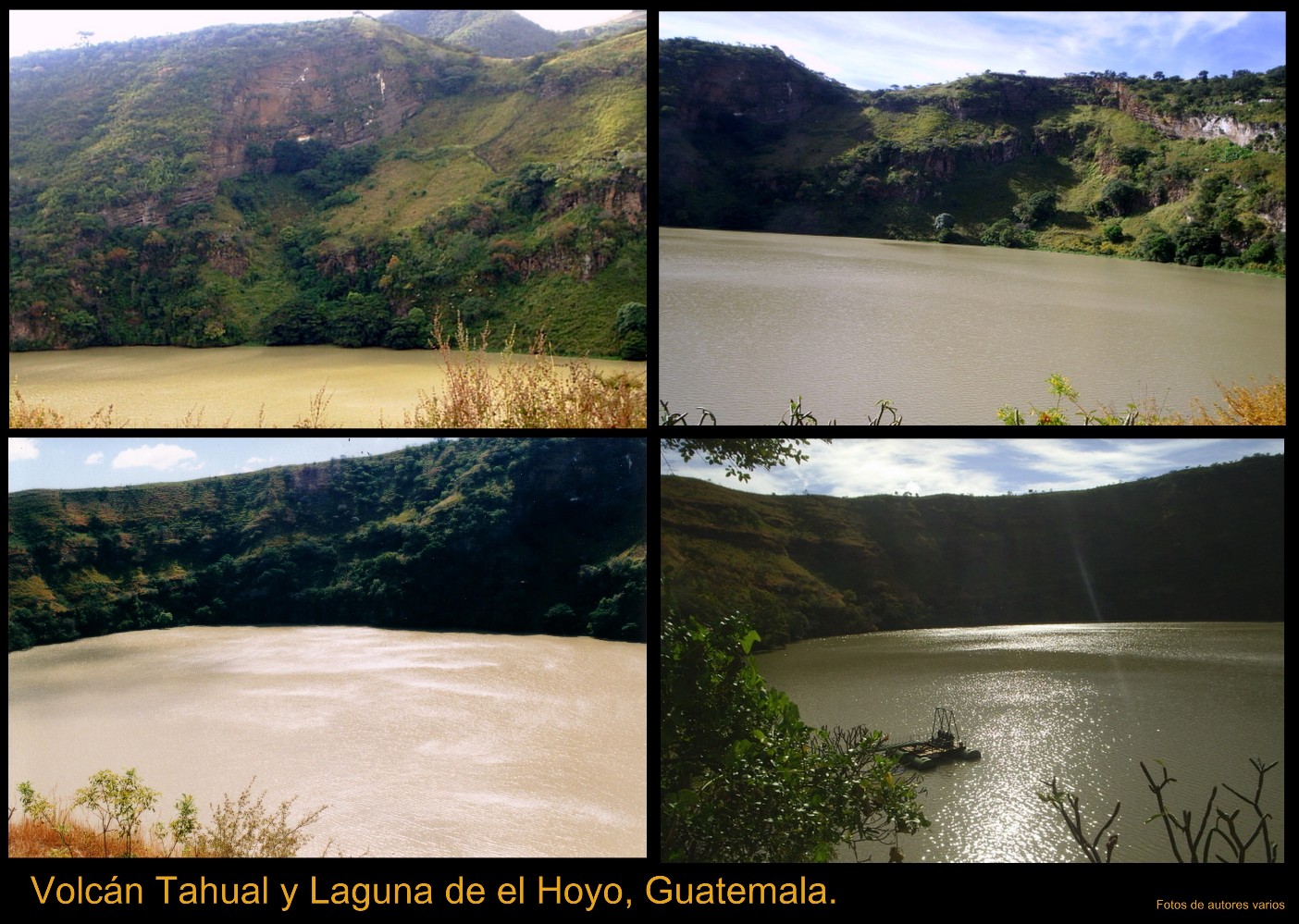
La Laguna del Hoyo |
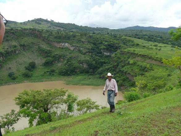
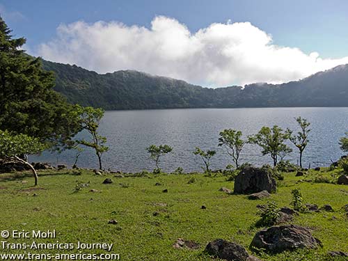
La Laguna del Hoyo is a large maar situated in the south-central part of the Nueva Santa Rosa quadrangle. Maars are caused by phreatic (steam) eruptions. Hot subterranean magma superheats the ground water to the point where the built-up pressure overcomes the strength of the overlying rock and causes the explosion. This is strictly a steam and debris eruption, however, no new magma is erupted -http://www2.brevard.edu/reynoljh/centralamerica/southcentralguat.htm |
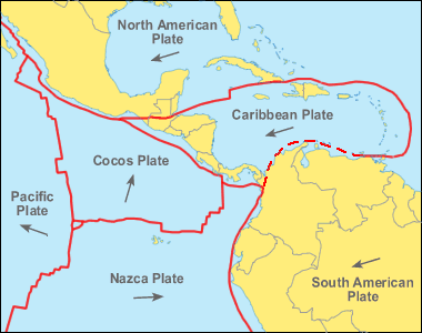
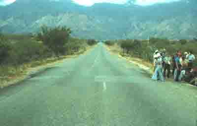
The fault line crossed the highway to Zacapa, offsetting the centerline. Tectonically, I was standing on the Caribbean Plate, looking across the Motagua Fault at the North American Plate. As can be seen in the photo, the Motagua Fault is a left-lateral strike-slip fault. The mountains in the background were elevated along other splays of the fault during prehistoric earthquakes 1976. |
Moyuta is situated at the southern edge of the Jaltapagua fault. The volcano has an elevation of 1662 m and its summit is formed by three andesitic lava domes. The slopes of the volcano complex have numerous cinder cones. Small fumaroles can be seen on the northern and southern slopes, and hot springs are found at the north-eastern base of the volcano, as well as along rivers on south-eastern side. Moyuta is the easternmost of a chain of large stratovolcanoes extending along the volcanic front of Guatemala. Like Tecuamburro volcano, Moyuta is offset about 20 km south of the main volcanic chain and lies south of the Jalpatagua Fault, overlying the southern boundary of the Jalpatagua Graben. The 1662-m-high volcano is capped by a cluster of at least three forested, steep-sided, coalescing andesitic lava domes that from some distant perspectives give the summit a flat-topped appearance. Numerous cinder cones in various stages of erosion are located on the flanks of the complex. The age of the latest eruption of Moyuta volcano is not known, although the summit domes were considered to have been emplaced in relatively recent times (Williams et al., 1964). Small fumaroles are found on the northern and southern flanks of the volcano, and hot springs are located near Azulco at the NE base and along rivers on the SE side of Moyuta. Last eruptions not known.Moyuta volcano rises above farmlands on the Pacific coastal plain of Guatemala. The densely forested volcano is extensively dissected and is mostly of Pliocene and Pleistocene age, but has a cluster of relatively youthful andesitic-to-dacitic lava domes at its summit. North-trending faults cut the summit area and form step-like ridges. Fumaroles, acid springs, and bicarbonate-rich hot springs are located on the northern and southern flanks of the volcano. http://www.volcano.si.edu/world/volcano.cfm?vnum=1402-13-&volpage=photos Moyuta is the easternmost of a chain of large stratovolcanoes extending along the volcanic front of Guatemala. The summit of the 1662-m-high volcano contains a cluster of forested lava domes. It is viewed here from a small lake to its SW at the edge of the Pacific coastal plain. The age of the latest eruption of Moyuta volcano is not known |
This view from the south shows a forested lava dome, one of a cluster of at least three steep-sided, coalescing andesitic-to-dacitic domes forming the summit of Moyuta volcano. The age of the domes is not known, but they are considered to be relatively recent features. The town of Moyuta, the outskirts of which are seen in the center of the photo, was constructed high on the volcano immediately adjacent to the summit dome complex.Photo by Lee Siebert, 1988 (Smithsonian Institution).http://www.volcano.si.edu/world/volcano.cfm?vnum=1402-13-&volpage=photos |
The large forested area at the middle right is the 1662-m-high Moyuta volcanic complex, its summit composed of a series of overlapping andesitic lava domes. The small white-colored area above and to the right of the dome complex is the city of Moyuta, which lies at an altitude of nearly 1300 m. Moyuta is the easternmost of the chain of large stratovolcanoes stretching across the Guatemalan Highlands. NASA Landsat image, 2000 (courtesy of Loren Siebert, University of Akron).http://www.volcano.si.edu/world/volcano.cfm?vnum=1402-13-&volpage=photos |
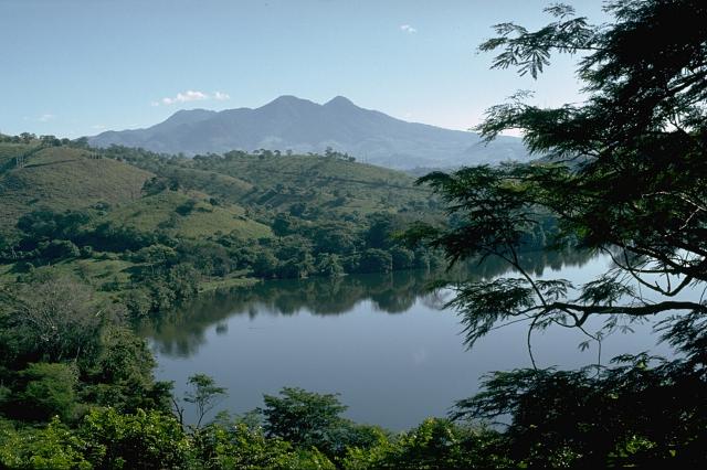
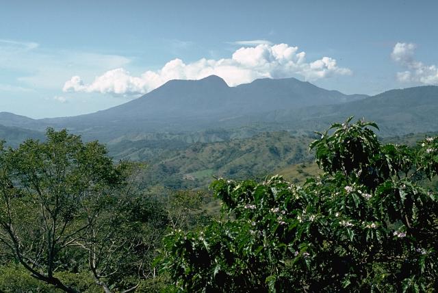
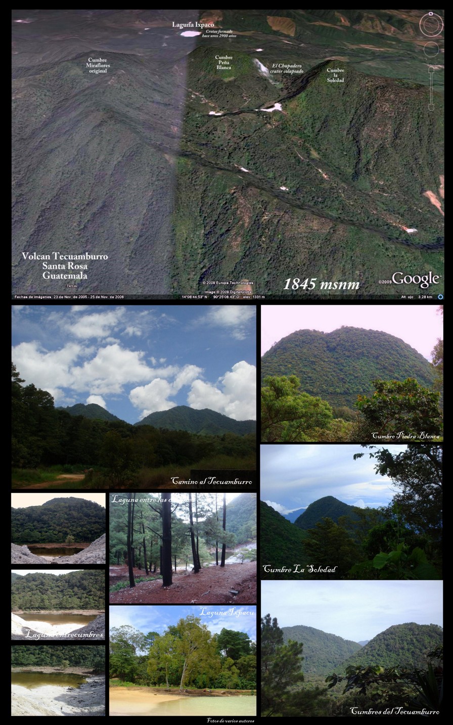
Tecuamburro is a stratovolcano, 1845 m, 960 BC, in southern Guatemala, is an andesitic stratovolcano which formed approximately 38,000 years ago inside a horseshoe-shaped caldera formed by a structural failure in a second, 100,000-year-old stratovolcano, known as Miraflores. At the top of the Tecuamburro is an acidic crater lake around which many hot springs, fumaroles, and boiling mudpots are found http://en.wikipedia.org/wiki/Tecuamburro |
Tecuamburro is a small, forested stratovolcano or large lava-dome complex of mostly Pleistocene age. It is located about 50 km ESE of Guatemala City, about 20 km south of the main volcanic chain. An ancestral andesitic stratovolcano, Miraflores, was formed about 100,000 years ago. Tecuamburro and other lava domes were constructed during the late Pleistocene or early Holocene within a horseshoe-shaped, east-facing caldera produced by structural failure of the older Miraflores stratovolcano prior to about 38,000 years ago. One of the largest of these domes, Peсa Blanca, overtops the NW rim of the collapse scarp. Two nested craters, the larger of which is Chupadero, lie at the NW end of the complex. The smaller crater is a phreatic tuff ring, Laguna Ixpaco, that was formed about 2900 years ago during the latest dated eruption of the Tecuamburro complex. Numerous fumaroles, hot springs, and boiling mud pots are found in the area around the acidic lake. No historical eruptions are known from Tecuamburro.1995m -http://www.authenticmaya.com/volcanoes.htm |
|
Volcano and Sulphur Ixpaco lagoon inside the crater. Volcano and Sulphur Ixpaco lagoon inside the crater ESE Guatemala Tecuamburro is a small, forested stratovolcano or large lava-dome complex of mostly Pleistocene age. It is located about 50 km ESE of Guatemala City, about 20 km south of the main volcanic chain. An ancestral andesitic stratovolcano, Miraflores, was formed about 100KA. Tecuamburro and other lava domes were constructed during the late Pleistocene or early Holocene within a horseshoe-shaped, east-facing caldera produced by structural failure of the older Miraflores stratovolcano prior to about 38KA. One of the largest of these domes, Pena Blanca, overtops the NW rim of the collapse scarp. Two nested craters, the larger of which is Chupadero, lie at the NW end of the complex. The smaller crater is a phreatic tuff ring, Laguna Ixpaco, that was formed about 2900 years ago during the latest dated eruption of the Tecuamburro complex. Numerous fumaroles, hot springs, and boiling mud pots are found in the area around the acidic lake. No historical eruptions are known from Tecuamburro.http://www.authenticmaya.com/volcanoes.htm |
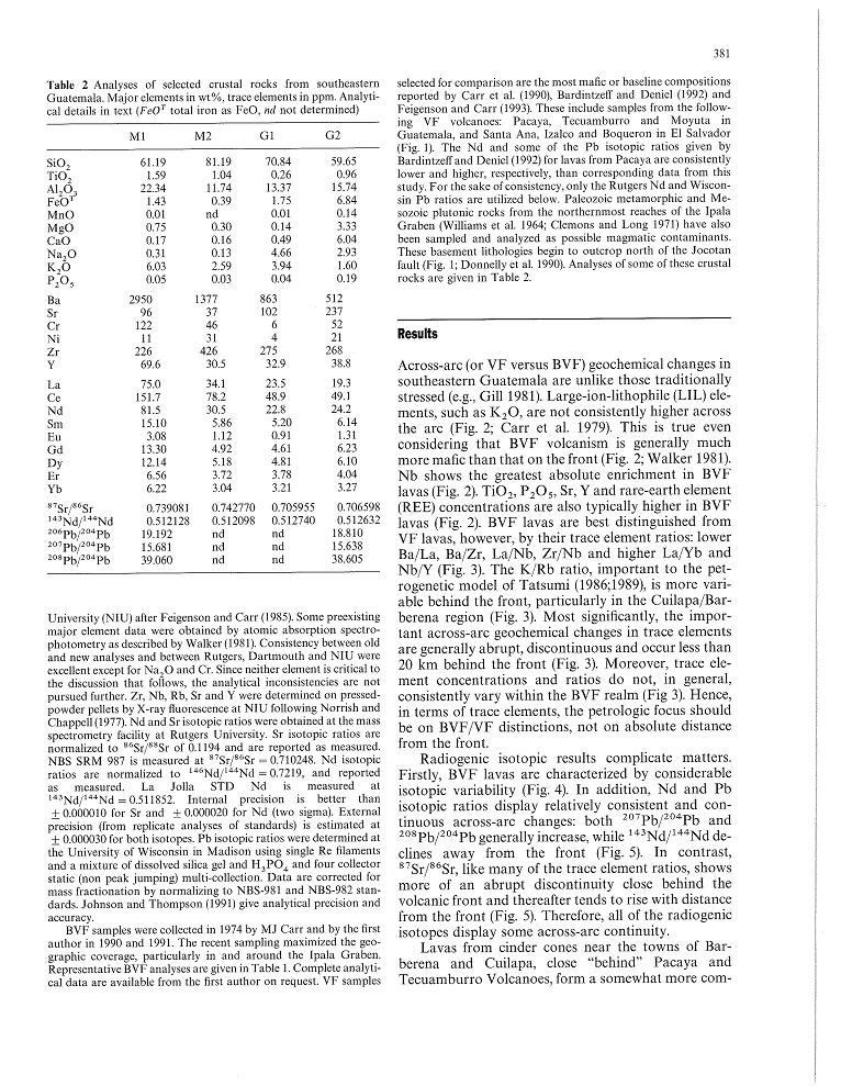
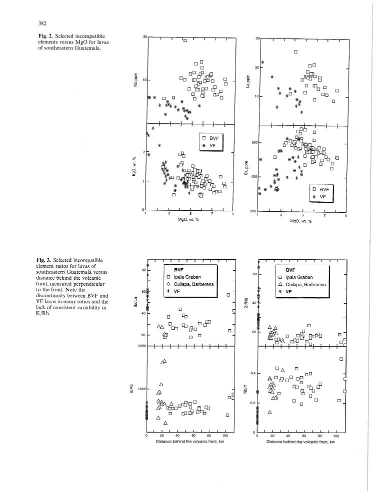
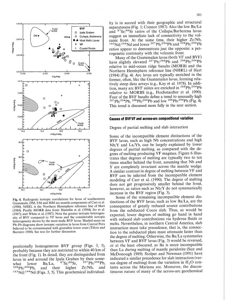
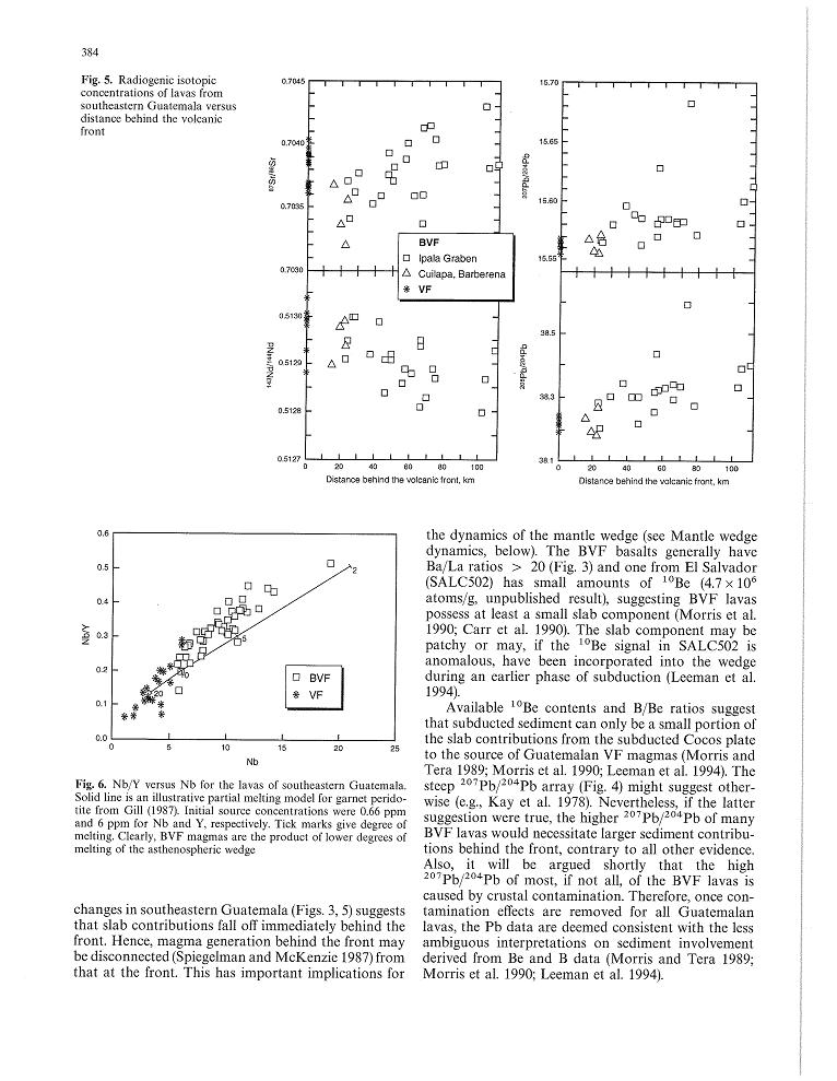
http://www.geology.wisc.edu/~unstable/PDF/Walker_et_al_1995_CMP.pdf |
http://www.geology.wisc.edu/~unstable/PDF/Walker_et_al_1995_CMP.pdf |
http://www.geology.wisc.edu/~unstable/PDF/Walker_et_al_1995_CMP.pdf |
http://www.geology.wisc.edu/~unstable/PDF/Walker_et_al_1995_CMP.pdf |
http://www.geology.wisc.edu/~unstable/PDF/Walker_et_al_1995_CMP.pdf |
http://www.geology.wisc.edu/~unstable/PDF/Walker_et_al_1995_CMP.pdf |
http://www.geology.wisc.edu/~unstable/PDF/Walker_et_al_1995_CMP.pdf |
http://www.geology.wisc.edu/~unstable/PDF/Walker_et_al_1995_CMP.pdf |
http://www.geology.wisc.edu/~unstable/PDF/Walker_et_al_1995_CMP.pdf |
http://www.geology.wisc.edu/~unstable/PDF/Walker_et_al_1995_CMP.pdf |
http://www.geology.wisc.edu/~unstable/PDF/Walker_et_al_1995_CMP.pdf |
|
http://www.neverstopexploring.com/blog/37-volcanoes-in-10-days/ |
Moyuta |
The large forested area at the middle right is the 1662-m-high Moyuta volcanic complex, its summit composed of a series of overlapping andesitic lava domes. The small white-colored area above and to the right of the dome complex is the city of Moyuta, which lies at an altitude of nearly 1300 m. Moyuta is the easternmost of the chain of large stratovolcanoes stretching across the Guatemalan Highlands. NASA Landsat image, 2000 (courtesy of Loren Siebert, University of Akron). |
Moyuta is a stratovolcano in southern Guatemala. It is located near the town of Moyuta in Jutiapa Department, and is situated at the southern edge of the Jaltapagua fault. The volcano has an elevation of 1662 m and its summit is formed by three andesitic lava domes. The slopes of the volcano complex have numerous cinder cones. Small fumaroles can be seen on the northern and southern slopes, and hot springs are found at the north-eastern base of the volcano, as well as along rivers on south-eastern side. The volcano is covered with forest. Eruptions unknown. Moyuta is the easternmost of a chain of large stratovolcanoes extending along the volcanic front of Guatemala. Like Tecuamburro volcano, Moyuta is offset about 20 km south of the main volcanic chain and lies south of the Jalpatagua Fault, overlying the southern boundary of the Jalpatagua Graben. The 1662-m-high volcano is capped by a cluster of at least three forested, steep-sided, coalescing andesitic lava domes that from some distant perspectives give the summit a flat-topped appearance. Numerous cinder cones in various stages of erosion are located on the flanks of the complex. The age of the latest eruption of Moyuta volcano is not known, although the summit domes were considered to have been emplaced in relatively recent times (Williams et al., 1964). Small fumaroles are found on the northern and southern flanks of the volcano, and hot springs are located near Azulco at the NE base and along rivers on the SE side of Moyuta. Moyuta is the easternmost of a chain of large stratovolcanoes extending along the volcanic front of Guatemala. The summit of the 1662-m-high volcano contains a cluster of forested lava domes. It is viewed here from a small lake to its SW at the edge of the Pacific coastal plain. The age of the latest eruption of Moyuta volcano is not known.http://en.wikipedia.org/wiki/Moyuta_(volcano) En este mismo lugar, en el caserio Los Ausoles, se encuentra un geiser. Un geiser es agua subterranea calentada por gases y rocas calientes, expulsada por la presion de vapor acumuladohttp://es.wikipedia.org/wiki/Volc%C3%A1n_Moyuta |
This view from the south shows a forested lava dome, one of a cluster of at least three steep-sided, coalescing andesitic-to-dacitic domes forming the summit of Moyuta volcano. The age of the domes is not known, but they are considered to be relatively recent features. The town of Moyuta, the outskirts of which are seen in the center of the photo, was constructed high on the volcano immediately adjacent to the summit dome complex.Photo by Lee Siebert, 1988 (Smithsonian Institution).http://www.volcano.si.edu/world/volcano.cfm?vnum=1402-13-&volpage=photos |
Moyuta volcano, seen here on the left-center horizon from the NW, is the easternmost of a chain of large stratovolcanoes extending across Guatemala. Its flat-topped summit is formed by a cluster of lava domes. Lava flows from the volcano interfinger with lacustrine deposits in the Jalpatagua valley, partly covered by the cloud bank below the volcano. The volcano lies south of the NW-SE-trending Jalpatagua Fault and overtops the southern margin of the Jalpatagua Graben, which lies on trend with the medial graben of El Salvador. The densely forested volcano is extensively dissected and is mostly of Pliocene and Pleistocene age, but has a cluster of relatively youthful andesitic-to-dacitic lava domes at its summit. North-trending faults cut the summit area and form step-like ridges. Fumaroles, acid springs, and bicarbonate-rich hot springs are located on the northern and southern flanks of the volcano.Photo by Lee Siebert, 1988 (Smithsonian Institution) http://www.volcano.si.edu/world/volcano.cfm?vnum=1402-13-&volpage=photos |
Chingo volcanic field |
Volcan Las Viboras, north of Volcбn Chingo, is a part of the Chingo volcanic field that lies entirely within Guatemala. Las Viboras lava shield (seen here from the north) is capped by a cinder cone. Las Viboras is the largest volcanic feature formed along a fault extending north from Volcan Chingo. Youthful lava flows of estimated Holocene age were erupted along this same fault on the northern flank of Las Viboras and on the NW side of the volcano.Photo by Giuseppina Kysar, 1999 (Smithsonian Institution) http://www.volcano.si.edu/world/volcano.cfm?vnum=1402-17-&volpage=photos |
Loma Los Siete Cerros (Peak of the Seven Hills) is a satellitic vent complex of the Volcan Chingo volcanic field. This complex of overlapping cinder cones on the Salvadoran side is seen here from the east and is one of many vents that flank the volcano. Among the youngest vents are those that produced lava flows on the NW side of the volcano in Guatemala. Other young flows issued from an intermittent chain of cones extending N-S on both side of the summit.Photo by Giuseppina Kysar, 1999 (Smithsonian Institution) http://www.volcano.si.edu/world/volcano.cfm?vnum=1402-17-&volpage=photos |
Panoramic view of Volcan Chingo. viewed from Cerro Las Viboras |
Volcan Chingo from the SE side shows several satellitic vents on the Salvadoran side of the volcano. Loma Los Siete Cerros appears at the left, and the rounded cone of Cerro Laguneta at the right. The knob on the horizon above Cerro Laguneta is Volcan Las Viboras, which, like Chingo itself, straddles the Guatemala/El Salvador border and is part of a long chain of N-S-trending vents.Photo by Giuseppina Kysar, 1999 (Smithsonian Institution).http://www.volcano.si.edu/world/volcano.cfm?vnum=1402-17-&volpage=photos Chingo volcano on the El Salvador-Guatemala border, Holocene. Chingo, 14.12 N, 89.73 W, 1775 m, stratovolcano. Volcan las Viboras, a cinder cone near Laguna Atescatempo. Eruptions have occurred from flank fissures which have produced lava flows on the western flank of Chingo, and the northern flank of Volcan las Viboras.No recent eruptions - http://www.volcanolive.com/guatemala.html A shallow, oval-shaped summit crater is breached on the western side. No historical eruptions are known from Chingo volcanic field. Other small stratovolcanoes and cinder cones are located on both sides of the volcano along a major N-S-trending fault. Other youthful cones, such as Cerro de Olla, lie across the Salvadorian border to the south. To the north in Guatemala, Volcan las Viboras, a cinder cone that caps a basaltic shield volcano, is the most prominent of several fault-controlled cones near Laguna Atescatempo. Flank fissures have fed many youthful lava flows, particularly on the western flank of Chingo and the northern flank of Volcan las Viboras. http://www.volcano.si.edu/world/volcano.cfm?vnum=1402-17- |
Volcan Chingo, a small, but prominent stratovolcano is the second highest of a cluster of volcanoes in SE Guatemala. It is seen here from the Guatemalan side above Laguna Atescatempo, which was created when lava flows from the Volcan Chingo area dammed local drainages. Many youthful basaltic cinder cones are located on the flanks of the volcano on both sides of the border.Photo by Lee Siebert, 1993 (Smithsonian Institution). http://www.volcano.si.edu/world/volcano.cfm?vnum=1402-17-&volpage=photos Volcan Chingo is a symmetrical stratovolcano that straddles the Guatemala/El Salvador border. The 1775-m-high conical volcano rises 900 m above its surroundings and is the most prominent regional landmark. A shallow, oval-shaped summit crater is breached on the western side. No historical eruptions are known from the Volcan Chingo volcanic field. Other small stratovolcanoes and cinder cones are located on both sides of the volcano along a major N-S-trending fault. Other youthful cones, such as Cerro de Olla, lie across the Salvadorian border to the south. To the north in Guatemala, Volcan las Viboras, a cinder cone that caps a basaltic shield volcano, is the most prominent of several fault-controlled cones near Laguna Atescatempo. Flank fissures have fed many youthful lava flows, particularly on the western flank of Chingo and the northern flank of Volcan las Viboras http://www.authenticmaya.com/volcanoes.htm |
Chingo aerial view is from the SW, the Guatemalan side of the volcano. The border with El Salvador extends from the bottom-right part of the photo through Volcan Chingo to Lake Guija at the upper left corner of the photohttp://www.volcano.si.edu/world/volcano.cfm?vnum=1402-17-&volpage=photos |
Las Viboras Volcano and Chingo near Atescatempa lagoon. Volcan las Viboras, a cinder cone 1100 m.that caps a basaltic shield volcano, is the most prominent of several fault-controlled cones near Laguna Atescatempo. Flank fissures have fed many youthful lava flows, particularly on the western flank of Chingo and the northern flank of Volcan las Viboras .http://www.authenticmaya.com/volcanoes.htm |
Flores (Volcan Amayo) , summit elevation 1600 m, volcanic field. Young lava flows occur at the NE base of the volcano, near El Aguacite. Flores is the most prominent stratovolcano in a volcanic field composed of several small volcanoes in southern Guatemala. http://www.volcanolive.com/guatemala.html |
Flores is one of the largest of a cluster of small stratovolcanoes located behind the volcanic front. Volcan de Flores, also known as Volcan Amayo, lies at the SW end of the SE Guatemala volcanic platform. The 1600-m-high summit rises up to 600 m above a basement of Cretaceous and Tertiary sedimentary rocks and contains a shallow crater breached on its eastern side. Satellitic cones occur at the southern and eastern base of the dominantly basaltic Flores volcano. Youthful lava flows occur at the NE base of the volcano, near El Aguacite http://www.volcano.si.edu/world/volcano.cfm?vnum=1402-14- Volcan de Flores is one of the largest of a cluster of small stratovolcanoes located in SE Guatemala behind the volcanic front. Volcan de Flores, also known as Amayo, lies about 10 km west of the city of Jutiapa, at the SW end of the SE Guatemala volcanic platform. The 1600-m-high summit rises up to 600 m above a basement of Cretaceous and Tertiary sedimentary rocks and contains a shallow crater breached on its eastern side. Satellitic cones occur at the southern and eastern base of the dominantly basaltic Flores volcano. Youthful lava flows occur at the NE base of the volcano, near El Aguacite,1600+ m .http://www.authenticmaya.com/volcanoes.htm |
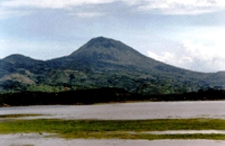
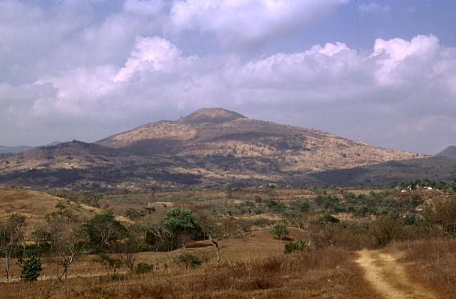
Tahual volcano |
Tahual, seen here from the NE. Tahual 14.43 N, 89.90 W, summit elevation 1716 m, stratovolcano. The volcano contains a cinder cone and lava flows. Laguna de Hoyo is located north of the volcano.No recent eruptions. http://www.volcanolive.com/guatemala.html |
|
Lago de Guija is a lake of volcanic dam. The lake is of volcanic origin and was formed by a large basaltic lava flow from the San Diego volcano which blocked the Guija depression''s original drainage. http://en.wikipedia.org/wiki/Lake_G%C3%BCija |
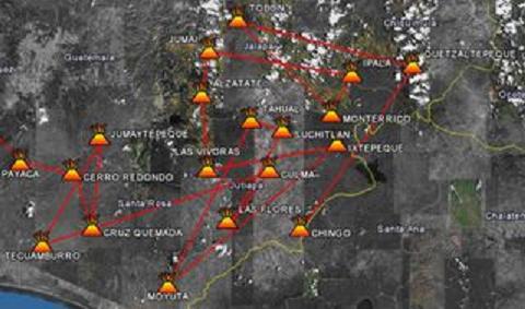
Jalapa |
Tobуn, 1800 mt. Jalapa |
Alzatate, 2045 m. Jalapa |
Jumay 2,176 m, Jumay Stratovolcano, 2,176 m, last eruptions not known.Jumay volcano is situated well behind the main volcanic chain in Central America. It is located just south of the Jocotбn Fault, the southernmost of the major faults that make up the plate boundary between the Caribbean and North American plates - http://www2.brevard.edu/reynoljh/centralamerica/southeasternguat.htm |
Volcan Ixtepeque is a stratovolcano. It consists of several rhyolitic lava domes and basaltic cinder cones. Its name is derived from the nahuatl word for obsidian. Ixtepeque was one of the most important obsidian sources in pre-Columbian Mesoamerica- http://en.wikipedia.org/wiki/Ixtepeque |
Ixtepeque Volcano 14.42 N, 89.68 W, summit elevation 1292 m , lava domes . The volcano contains the largest obsidian field in north America. Obsidian from Ixtepeque has been found in archaeological sites across Central America. Eruptions within the past few thousand years.http://www.volcanolive.com/guatemala.html Ixtepeque volcano, which takes its name from the Aztec word for obsidian, is perhaps the largest obsidian field in North America. A 4 x 5 km wide rhyolitic obsidian lava field was erupted within the Ipala graben from a craterless vent along a NE-trending fissure that passes through adjacent rhyolitic lava domes and basaltic cinder cones. Obsidian from Ixtepeque has shown up at archaeological sites across Central America. Flat-lying pumice beds produced by explosive eruptions preceding lava effusion are found locally around the volcano. Other obsidian flows originated from lava domes NE of Ixtepeque. These rhyolitic vents are interspersed with basaltic cinder cones and lava flows. Laguna de Obrajuelo is a complex cone cut by a large crater more than a km in diameter. Initial basaltic eruptions were followed by the extrusion of obsidian flows and the eruption of rhyolitic pumice that were considered by Williams et al. (1964) to be only a few thousand years old.Holocene -http://www.volcano.si.edu/world/volcano.cfm?vnum=1402-18- |
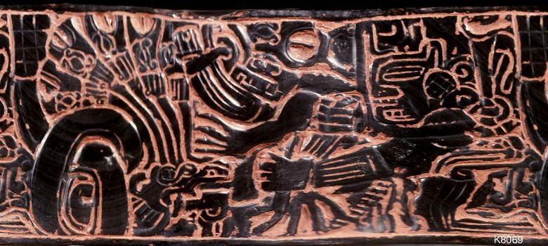
Carved obsidian vase Serpent with snakes emerging from its head. Obsidian from Ixtepeque has shown up at archaeological sites across Central America.-http://www.authenticmaya.com/Obsidian.htm |
Ixtepeque volcano, 1292, which takes its name from the Aztec word for obsidian, is perhaps the largest obsidian field in North America, including red obsidian.. A 4 x 5 km wide rhyolitic obsidian lava field was erupted within the Ipala graben from a craterless vent along a NE-trending fissure that passes through adjacent rhyolitic lava domes and basaltic cinder cones. Flat-lying pumice beds produced by explosive eruptions preceding lava effusion are found locally around the volcano. Other obsidian flows originated from lava domes NE of Ixtepeque. These rhyolitic vents are interspersed with basaltic cinder cones and lava flows. Laguna de Obrajuelo is a complex cone cut by a large crater more than a km in diameter. Initial basaltic eruptions were followed by the extrusion of obsidian flows and the eruption of rhyolitic pumice that were considered by Williams et al. (1964) to be only a few thousand years old http://www.authenticmaya.com/volcanoes.htm |
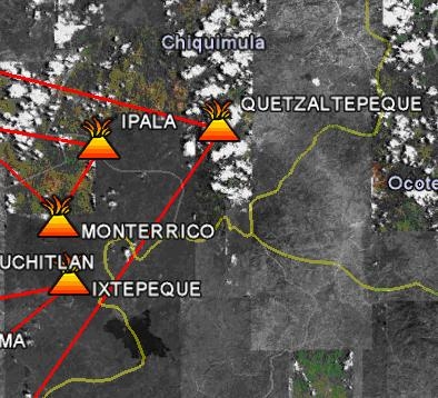
El volcan Monte Rico, o Monterrico, es un volcan de la zona oriental, 1,285 m, cono de escorias, parasito del volcбn Ipala y de constitucion rocosa de basalto olivinico (Bohnenberger, 1969). http://wikiguate.com.gt/wiki/Volc%C3%A1n_Monte_Rico |
Ipala Volcano 14.55 N, 89.63 W , summit elevation 1650 m, stratovolcano . The summit contains a 1 km wide crater. Monte Rico is a cone located on the southern flank. The most recent eruptions were produced along a 17 km long NNE-SSW fissure that produced a line of cinder cones and associated basaltic lava flows covering 20 sq km. No recent eruptions http://www.volcanolive.com/guatemala.html |
Ipala and Monterrico. Volcan Ipala has a 1,000 m wide summit crater which contains a crater lake (Lake Ipala), whose surface lies about 150 m below the crater rim. Volcan Ipala is part of a cluster of small stratovolcanoes and cinder cone fields in south-eastern Guatemala - http://en.wikipedia.org/wiki/Volc%C3%A1n_Ipala Ipala is part of a cluster of closely spaced small stratovolcanoes and cinder cone fields in SE Guatemala. The summit of the 1650-m-high stratovolcano is cut by a 1-km-wide crater containing a lake. The eastern flank of the small Monterrico stratovolcano, seen here from the SW, is cut by a line of Holocene cinder cones and lava flows. Monte Rico is the prominent cinder cone on the south flank (right skyline). No historical eruptions are known from Ipala http://www.authenticmaya.com/volcanoes.htm |
View of the lake inside the cone of Ipala |
Ipala crater lake |
Quezaltepeque is a volcanic field in Chiquimula. It has erupted in the Holocene. It is an area of basaltic lava flows was erupted from vents along a north-south trending fault without explosions, cutting through Tertiary pyroclastic rocks WNW of Ipala volcano. These basaltic flows issued passively from vents along a N-S-trending fault without accompanying explosive activity. There are mounds of lava over the vents. A series of youthful lava flows was erupted from vents cutting through Tertiary pyroclastic rocks .The vents are capped by low mounds of lava. The flows were considered to be of Holocene age by Williams et al. (1964). http://www.volcano.si.edu/world/volcano.cfm?vnum=1402-21-&volpage=photos |
Quezaltepeque, 14.65 N, 89.35 W , summit elevation 1200 m. Undated eruptions. The right side of the relatively cloud-free area at the center of this NASA Landsat image (with north to top) contains the Quezaltepeque volcanic field. A series of youthful lava flows was erupted from vents along a N-S-trending fault cutting through Tertiary pyroclastic rocks about 5 km south of the town of Quezaltepeque. The northern end of Lake Gьija along the Guatemala/El Salvador border is at the bottom of the image, and the city of Chiquimula is at the top center. The fault-controlled Rнo Motagua valley is at the upper left.NASA Landsat7 image (worldwind.arc.nasa.gov)http://www.volcano.si.edu/world/volcano.cfm?vnum=1402-21-&volpage=photos&photo=114071 |
Quezaltepeque.The right side of the relatively cloud-free area at the center of this NASA Landsat image (with north to top) contains the Quezaltepeque volcanic field. A series of youthful lava flows was erupted from vents along a N-S-trending fault cutting through Tertiary pyroclastic rocks about 5 km south of the town of Quezaltepeque. The northern end of Lake Gьija along the Guatemala/El Salvador border is at the bottom of the image, and the city of Chiquimula is at the top center. The fault-controlled Rнo Motagua valley is at the upper lefthttp://www.authenticmaya.com/volcanoes.htm |
Quezaltepeque |
The Chiquimula volcanic field, 1192 m, occupies a fault-bounded basin underlain by Cretaceous plutonic rocks in the Chiquimula Valley of SE Guatemala. Initial eruptions during the Pleistocene produced mesa-forming basaltic lava flows along the N-S-trending fault forming the eastern edge of the Ipala graben. These were followed by the eruption of widespread lava flows NW of Chiquimula town that covered about 12 sq km. The most recent eruptions produced basaltic cinder cones and lava flows near the northern edge of Chiquimula town. The cinder cones were constructed along a N-S-trending fracture, with Cerro Grande at the northern end being the largest and Cerro Chiquito at the southern end being the youngest. The lava flows from Cerro Chiquito are so fresh and sparsely vegetated they were considered by Williams et al. (1964) to possibly be less than 1000 years old. http://www.authenticmaya.com/volcanoes.htm |
The youngest vents of the Chiquimula volcanic field were erupted along a N-S-trending fracture north of the town of Chiquimula. They are seen here from the NE, north of the town of Petapilo. The northernmost of the young cones, Cerro Grande, is the oldest and largest. The youngest lava flows originated from fissure vents at Cerro Chiquito. The age of these unvegetated flows is not known, but they may be less than a thousand years old.Photo by Giuseppina Kysar, 1999 (Smithsonian Institution).http://www.volcano.si.edu/world/volcano.cfm?vnum=1402-20-&volpage=photos |
The Chiquimula Holocene volcanic field, cinder cone, occupies a fault-bounded basin underlain by light-colored Cretaceous plutonic rocks in the Chiquimula Valley of SE Guatemala. The most recent eruptions produced basaltic cinder cones and lava flows constructed along a N-S-trending fracture starting near the northern edge of Chiquimula town. Part of the town is seen on the valley floor to the right of the hill in the center of this photo, taken from the NW along the road to Maraxco.Photo by Giuseppina Kysar, 1999 (Smithsonian Institution).http://www.volcano.si.edu/world/volcano.cfm?vnum=1402-20- 14.83 N, 89.55 W, 1192 m, contains cinder cones and lava flows.Young looking lava flows may have been erupted in the past 1000 years. Undated eruptions. http://www.volcanolive.com/guatemala.html |
Volcan Tahual 14.43 N, 89.90 W , summit elevation 1716 m , stratovolcano. The volcano contains a cinder cone and lava flows. Laguna de Hoyo is located north of the volcano. No recent eruptions.http://www.volcanolive.com/guatemala.html Tahual 14.43 N, 89.90 W , summit elevation 1716 m, stratovolcano is located south of the town of Monjas. The volcano contains a cinder cone and lava flows. Laguna de Hoyo is located north of the volcano. No recent eruptions http://www.volcanolive.com/tahual.html |
Jumay Stratovolcano, 2,176 m, last eruptions not known.Jumay volcano is situated well behind the main volcanic chain in Central America. It is located just south of the Jocotбn Fault, the southernmost of the major faults that make up the plate boundary between the Caribbean and North American plates - http://www2.brevard.edu/reynoljh/centralamerica/southeasternguat.htm |
The Retana Caldera used to be flooded by a shallow lake. The lake was drained so that the rich soil on the lake bottom could be used for agriculture -http://www2.brevard.edu/reynoljh/centralamerica/southeasternguat.htm |
The elongated Suchitan volcano, seen here from the west on the rim of Retana caldera, is the highest of a cluster of closely spaced small stratovolcanoes and basaltic cinder-cone fields in SE Guatemala. The large peak to the left of the 2042-m-high summit of Suchitбn is Cerro Mataltepe; other cinder cones occur lower on the north flank. One of the latest lava flows from Suchitбn traveled through a low notch in the east rim of the caldera. The flat-bottomed floor of Retana caldera once contained a lake, but now is used for agricultural land. http://www.volcano.si.edu/world/volcano.cfm?vnum=1402-16- |
Volcan Suchitan, NE of the city of Jutiapa, is one of the largest volcanoes in SE Guatemala. The 2042-m-high summit of the andesitic-to-basaltic stratovolcano is elongated in a N-S direction. Several large canyons cut the slopes of the dominantly andesitic edifice. A large parasitic cone, Cerro Mataltepeque, 1814 m, is located on the upper northern flank, and two smaller cones are located on the lower northern flank. Two basaltic lava flows of Holocene age are located on the northern and NW flanks (Williams et al., 1964), and many flank vents are basaltic. Suchitan was constructed immediately to the east of the 5-km-wide basaltic-to-dacitic Retana caldera, formed in part in association with the eruption of a dacitic pumice deposit. Steep walls 60-250-m high rise above the flat caldera floor. One of the latest basaltic lava flows from Suchitan flowed through a low notch in the eastern caldera rim. Several lava cones and a maar are located along a N-S line north of Retana caldera. A reported eruption of Suchitan in 1469 is considered to have actually been from Atitlan volcano in the Guatemalan highlands http://www.authenticmaya.com/volcanoes.htm Like all of the volcanoes in southeastern Guatemala, Suchitan has no recorded eruptive activity |
A cluster of cones and low shield volcanoes surrounds the city of Jutiapa in SE Guatemala. The most prominent feature is Cerro Santiago, one of two coalescing cinder cones capping a low shield volcano SE of Jutiapa., flows from the twin Los Cerritos cones NE of Jutiapa cross the Interamerican highway. Volcan Culma forms a steep-sided basaltic lava mound immediately east of the city. To the west, Cerro Gordo or Volcano Amayo), a craterless cinder cone surrounded by basaltic lava flows. It is one of several cinder cones to have produced lava flows that blanket the landscape between Jutiapa and Tertiary volcanic hills to the south.http://www.authenticmaya.com/volcanoes.htm |
Santiago,14.33 N, 89.87 W , summit elevation 1192 m , volcanic field . Santiago volcano consists of a cluster of cinder cones located NE of Jutiapa. No recent eruptions. http://www.volcanolive.com/guatemala.html |
Culma, 1,027m http://www.authenticmaya.com/volcanoes.htm |
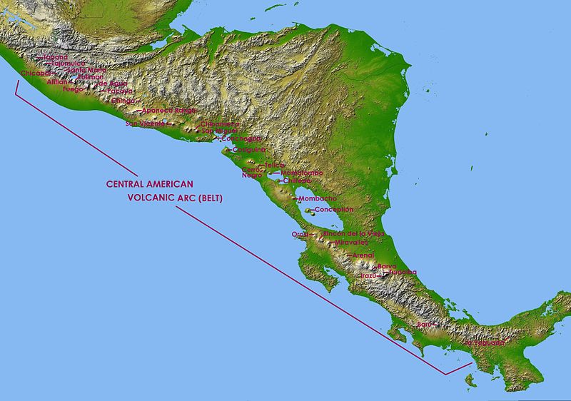

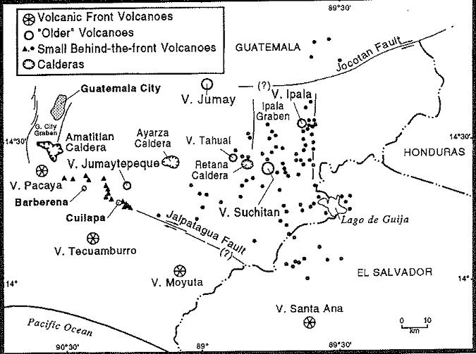

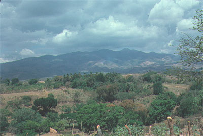
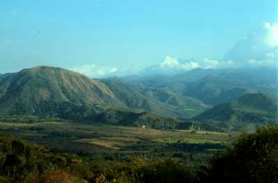


The volcanoes in southeastern Guatemala are distinct from those in the rest of the Central American volcanic chain. None of them have any recorded eruptions but most appear to have been active in the Pleistocene. They are not aligned along a single axis. Instead, they are scattered all over southeastern Guatemala, extending almost as far inland as the plate boundary. Ayarza volcano, is usually categorized as part of southeastern Guatemala. Below are photos of some of these cones that I took while driving around southeastern Guatemala in the fall of 1976 in search of exposures of Tertiary volcanic rocks. Relatively little is known about most of these mountains. The leading hypothesis for their anomalous appearance is that a sliver of the subducting Cocos Plate is descending at a very low angle- http://www2.brevard.edu/reynoljh/centralamerica/southeasternguat.htm
http://www.volcanolive.com/tahual.html
http://www.authenticmaya.com/volcanoes.htm
http://en.wikipedia.org/wiki/Central_America_Volcanic_Arc
http://en.wikipedia.org/wiki/List_of_volcanoes_in_Guatemala
http://geology.com/rocks/igneous-rocks.shtml Igneous Rocks
RES Volcanology grad program
http://www.authenticmaya.com/volcanoes.htm
http://en.wikipedia.org/wiki/List_of_volcanoes_in_Guatemala
http://www.volcanolive.com/guatemala.html
https://www2.brevard.edu/reynoljh/grandcanyon/canyon1.htm
http://www2.brevard.edu/reynoljh/vita/magnetostratigraphy.html