 | South Costa Rica. Volcanoes |
|
|
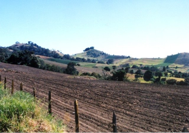
http://en.wikipedia.org/wiki/Cordillera_de_Tilar%C3%A1n#Mountain_ranges |
|
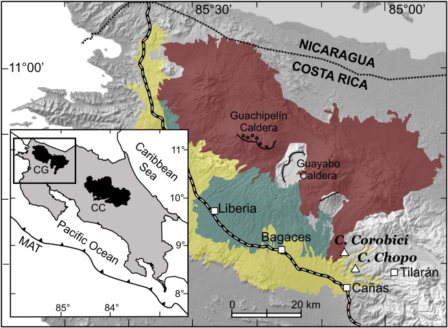
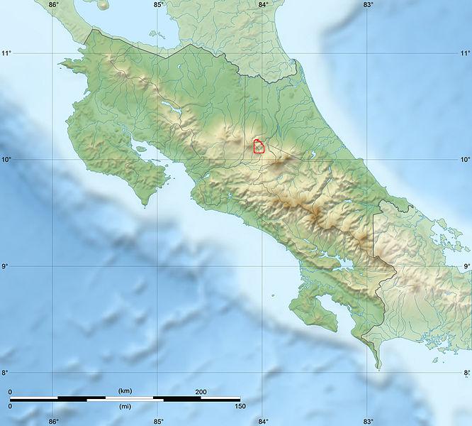
The inset shows Costa Rica and its two volcanic ranges the Cordillera Central (CC) and the Cordillera de Guanacaste (CG). The last one is also shown in the shaded relief as the darker region. The middle gray area corresponds to the ignimbritic fan deposits (1.6�0.6 Ma) from two recent calderas, and the brightest gray is the Bagaces ignimbritic plateau (2�4 Ma). http://www.sciencedirect.com/science/article/pii/S0377027310003549 |
|
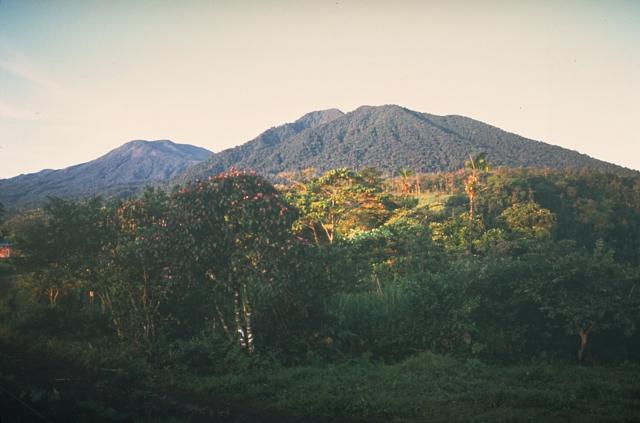
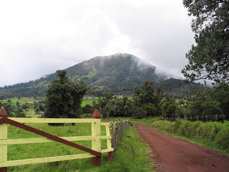
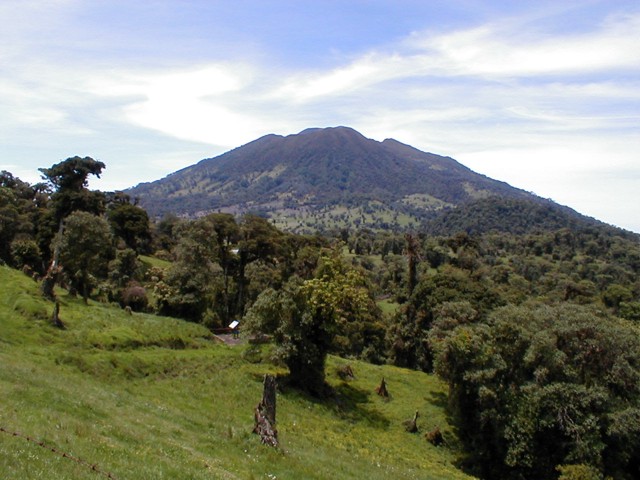
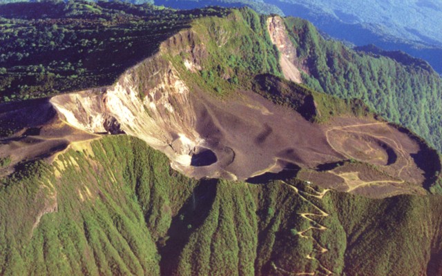
Located within Braulio Carrillo National Park, the conical Cacho Negro Volcano sits less than five miles from Poas Volcano. Cypress and pine forest surround the dormant volcano, and a variety of flora and fauna live on the verdant mountain slopes. (2.136 m.a.s.l.). Extinct volcano that is situated in the central part of Braulio Carillo National Park. It`s known for its perfect conical shape. Its slopes are covered with cypress and pine forests |
Congo Volcano is located less than four miles north of Poas Volcano, one of the country�s most popular attractions. Poas Volcano National Park was expanded in 1993 to include Congo within its boundaries. Trails through the park wind past the volcano, but due to its seclusion, Congo is difficult to reach. Always consult with a park ranger before hiking out to Congo Volcano.Congo Volcano is now named for the congos, or howler monkeys that inhabit its verdant slopes. Though ancient lava flows paved the way for the valleys and river canyons that now surround the volcano, scientists estimate that the mountain has lain dormant for almost 6,000 years. |
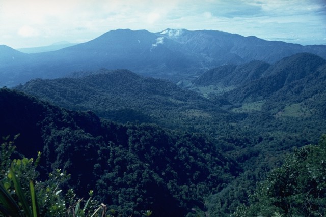
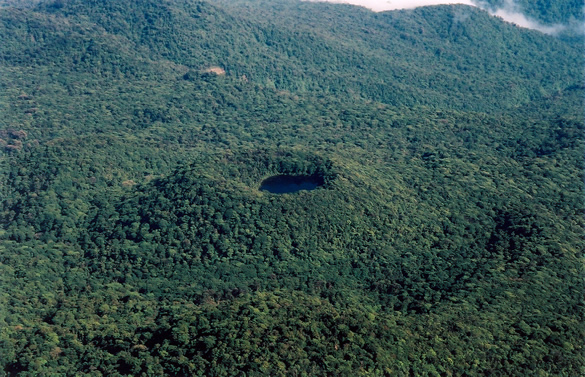
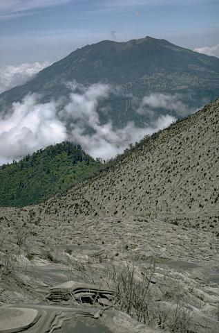
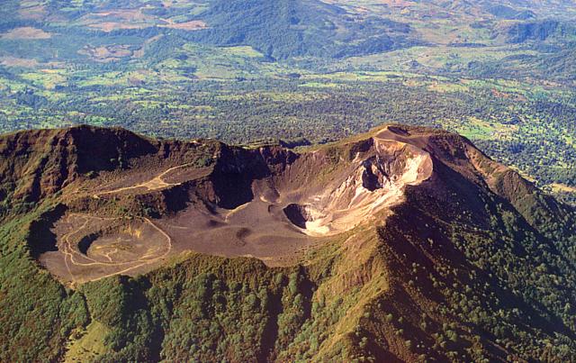
Cerro Congo lies about 6 km north of Poas volcano and was constructed along a N-S-trending chain of vents that extends into the Caribbean coastal plain in the background. The summit crater of the 2014-m-high stratovolcano, located at the northern end of Poas National Park, is breached to the NW. Howler monkeys abound in the forests blanketing the cone, and provide the name of the volcano. Cerro Congo was active during the late Pleistocene and Holocene until about 5000 years ago.Photo by Federico Chavarria Kopper, 1999 (courtesy of Eduardo Malavassi, OVSICORA-UNA). http://www.volcano.si.edu/world/volcano.cfm?vnum=1405-04=&volpage=photos |
The broad Poas volcanic complex was constructed during eruptions along a N-S line. This photo from the NE shows the north-flank of 2014-m-high Cerro Congo stratovolcano in the center, with the 2639-m-high von Frantzius cone in the left background. The latest activity from Cerro Congo produced a pyroclastic-flow deposit radiocarbon dated at about 5140 yrs ago. The Laguna Hule maar at the north end of the Poas complex is located at the base of Cerro Congo, out of view to the right.Photo by Mike Carr, 1983 (Rutgers University). http://www.volcano.si.edu/world/volcano.cfm?vnum=1405-04=&volpage=photos |
Steam clouds are visible in the distance rising from the active summit crater (center horizon) of Poas volcano in this view from the NW. The flat peak behind the steam clouds is the Botos cone (the high point of the Poбs massif), and the forested peak to its left is von Frantzius cone. The slopes of Cerro Congo lie across a saddle from von Frantzius on the extreme left horizon. Two large calderas, the youngest of which formed about 40,000 years ago, are located at the broad summit of the volcano.Photo by Dick Berg, 1969 (courtesy of William Melson, Smithsonian Institution). http://www.volcano.si.edu/world/volcano.cfm?vnum=1405-04=&volpage=photos |
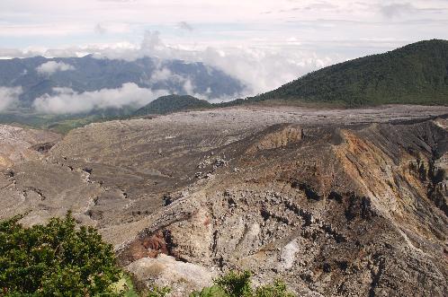
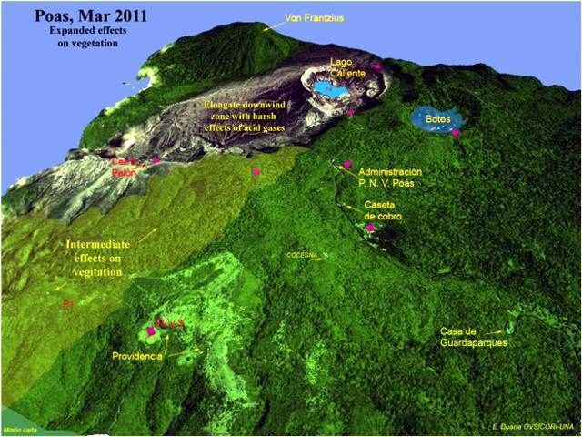
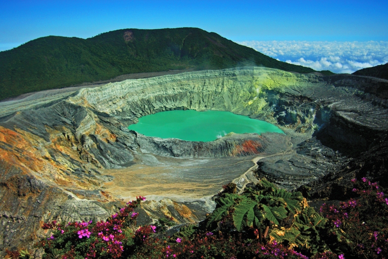
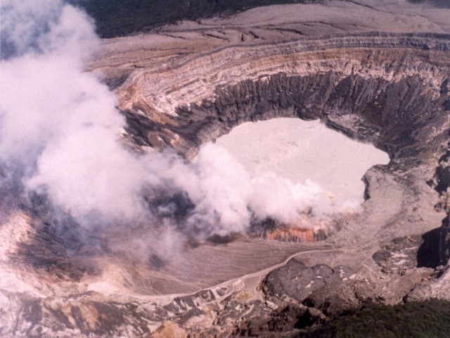
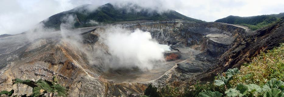
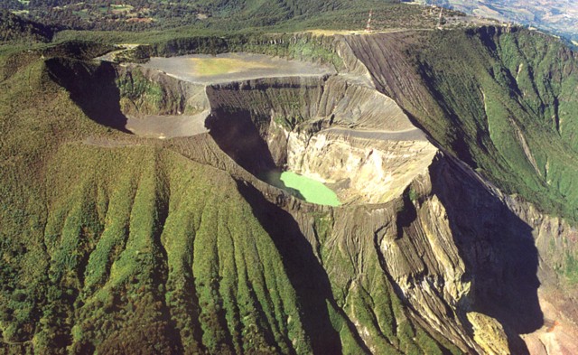
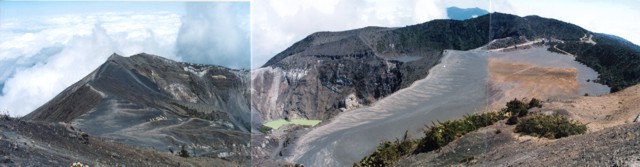
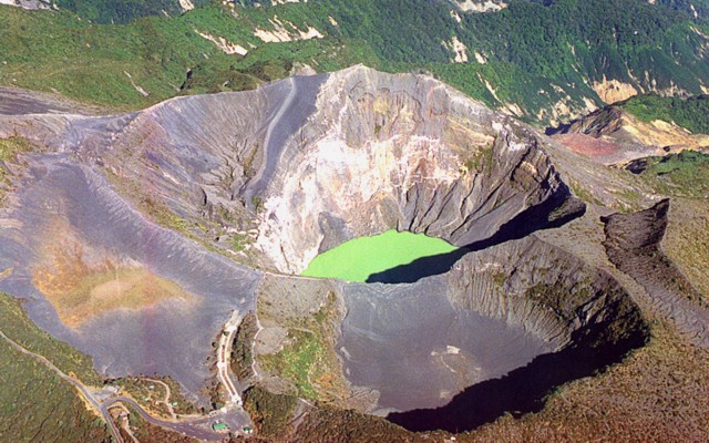
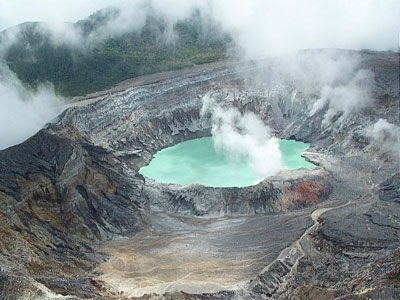
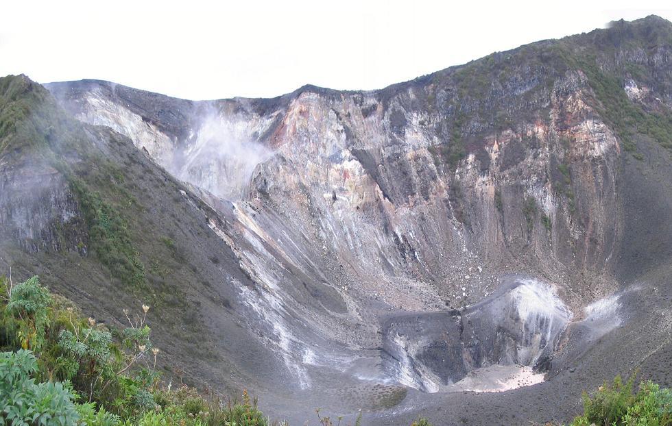
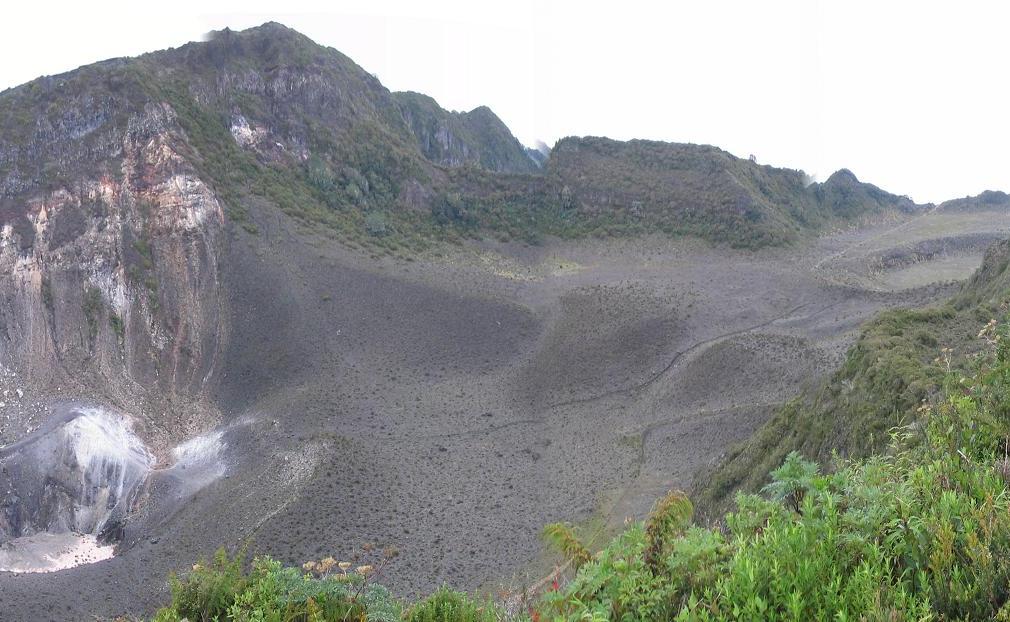
Poas. Oblique view highlighting the area to the S of Poas (note volcano''s crater lakes, including the active "Lago Caliente") On color versions of this figure, the pink rhombuses show sites for collecting acid rain. Providencia is shown in the lower left. The crater lake at upper right, "Botos" is ~0.5 km across in the long direction but the scale on this image varies with distance towards the foreground.A comparison of vegetation in the area between Cerro Pelon and Providencia (designated "F1" ) made during August 2010 to January 2011 found that most plant species were resistant at certain levels of acidification. However, when their tolerance thresholds were reached, the affected species decayed quickly and were sometimes unable to recover. Certain species, including eucalyptus, pine, alder, and cypress, were particularly sensitive to the volcanic gases. Minor effects from gases were observed on Cypress trees as far as 9 km SW of the emission source. OVSICORI-UNA reports contained several photos showing more details on the effects of acidic gases on vegetation. One of their later reports, from April 2011, discussed ongoing phreatic eruptions and dome temperature of 560�C. Courtesy E. Duarte, OVSICORI-UNA.http://www.volcano.si.edu/reports/bulletin/contents.cfm?issue=3604&display=complete The broad, well-vegetated edifice of Poas, one of the most active volcanoes of Costa Rica, contains three craters along a N-S line. The frequently visited multi-hued summit crater lakes of the basaltic-to-dacitic volcano, which is one of Costa Rica''s most prominent natural landmarks. A N-S-trending fissure cutting the 2708-m-high complex stratovolcano extends to the lower northern flank, where it has produced the Congo stratovolcano and several lake-filled maars. The southernmost of the two summit crater lakes, Botos, is cold and clear and last erupted about 7500 years ago. The more prominent geothermally heated northern lake, Laguna Caliente, is one of the world''s most acidic natural lakes, with a pH of near zero. It has been the site of frequent phreatic and phreatomagmatic eruptions since the first historical eruption was reported in 1828. Poas eruptions often include geyser-like ejections of crater-lake water. Poas, one of the most active volcanoes of Costa Rica, is a broad, well-vegetated volcano with a summit area containing three craters along a N-S line. The 2708-m-high volcano is constructed within eroded remnants of two nested calderas |
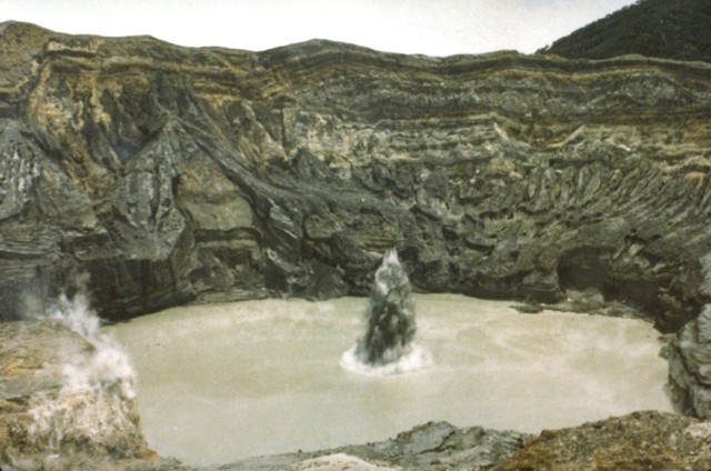
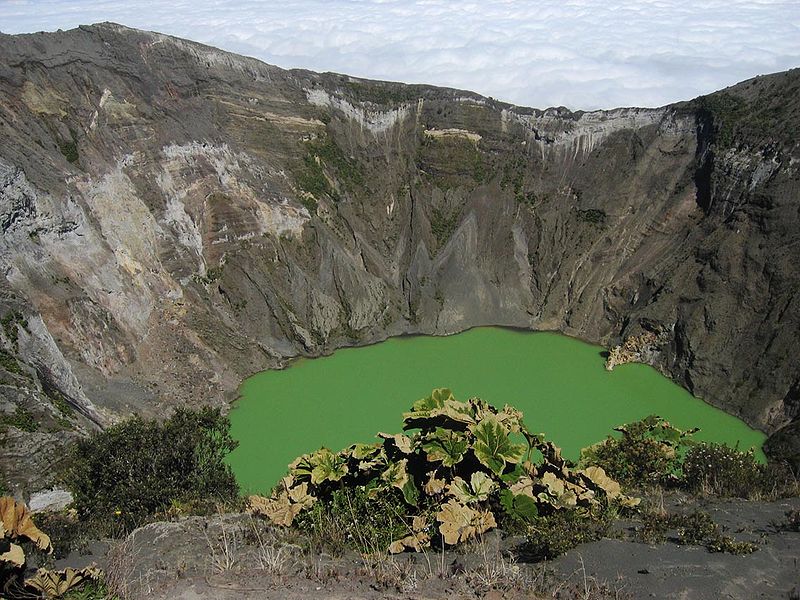
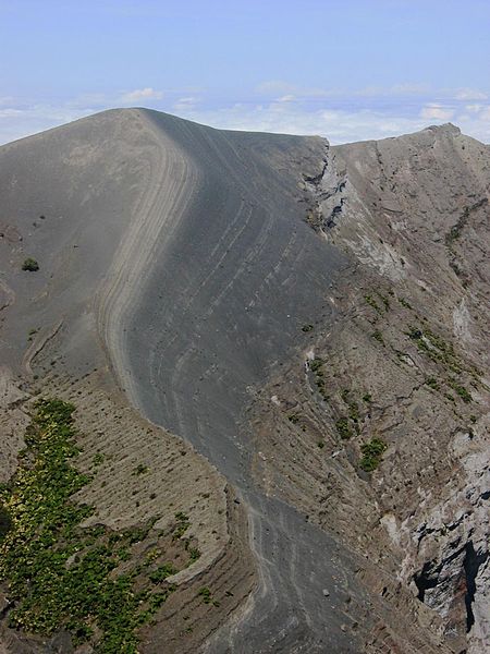
Volcano Poas It has three craters, only one active. It measures 1500 meters length (the second widest crater of the world), and 300 m of depth. On its bottom there is the most active bubbling lake in the world. Its geiser eruptions shoot 40 m high. To the north from the main crater, Von Frantzius crater (the oldest one) is situated (it`s named after german doctor who searched it in 1860). The third crater Botos is filled with blue water lake and ringed by thick forests. On the west side of volcano winds the Toro Amarillo river.The first mention of Poas volcanic activity dates back to 1834. The first naturalist to visit Poas was Dane Andres Sandoe Oersted in 1863. Its eruption from 1889 came an earthquake, due to which, a piece of volcanic wall was torn off and a deep hole filled with water was made. During the eruption from 1910, the ash cloud was shot 8000 meters into the air. In 1952-1954 there were similar cloud ashes substituted by deep tremors. Since 1989 the increase of gas emissions has been observed. It''s blamed for acid rains, that destroyed the strawberry plantations on the western side of volcano.There are two crater lakes near the summit. The northern lake is known as the Laguna Caliente and is located at a height of 2,300 m in a crater approximately 1.7 km wide and 290�300 m deep. It is one of the world''s most acidic lakes. The acidity varies after rain and changes in volcanic activity, sometimes reaching a pH of almost 0; consequently, it supports little or no aquatic life. The bottom of this lake is covered with a layer of liquid sulphur. Acid gases create acid rain and acid fog, causing damage to surrounding ecosystems and often irritation of eyes and lungs.Lake Botos, the southern lake, fills an inactive crater, which last erupted in 7500 BC. It is cold and clear, and is surrounded by a cloud forest located within the Poas Volcano National Park.Poas was near the epicenter of a 6.1-magnitude earthquake in January 2009.There was also eruptive activity in 2009 involving minor phreatic eruptions and landslides within the northern active crater. Poбs eruptions often include geyser-like ejections of crater-lake water. Forested von Frantzius cone in the background was constructed along the buried northern rim of the innermost of two large nested calderas cutting the summit of Poas. The crater lake has been the source of frequent geyser-like phreatic eruptions during historical time and is the featured attraction of Poas National Park. A prominent bench formed by lava flows and pyroclastic material is found at the eastern side of the crater. The diameter and depth of the crater lake varies with seasonal rainfall and eruptive activity; on occasion the lake has disappeared. Pyroclastic eruptions through the crater lake have sometimes ejected scoria formed from molten sulfur. http://en.wikipedia.org/wiki/Po%C3%A1s_Volcano |
A vertical view into the crater lake of Poas volcano in December 1999 shows a steam plume (bottom center) originating from the pyroclastic cone on the south side of the lake. December plume heights ranged between 0.7 and 1 km. The 800-m-wide crater contains an acidic lake of variable dimensions. The steaming pyroclastic cone was formed during eruptive activity from 1953 to 1955. Photo by Federico Chavarria Kopper, 2000. http://www.volcano.si.edu/world/volcano.cfm?vnum=1405-04=&volpage=photos |
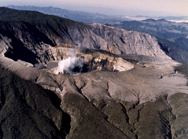
The steaming main crater of Poas volcano, seen here in an aerial view from the NE, lies within the smaller of two nested calderas at the summit of the volcano. This inner caldera is elliptical and is 4 km wide in its longer N-S direction, but is not well-exposed topographically. A tourist overlook along the ESE crater rim near the upper left provides a frequently visited vantage point into the crater in the popular Poas National Park. Photo by National Aeronautics and Space Administration (NASA), 1982. http://www.volcano.si.edu/world/volcano.cfm?vnum=1405-04=&volpage=photos |
This February 1982 photo of the active crater of Poas volcano shows a vigorous steam plume pouring from fumarolic vents on the southern crater rim. The northern crater wall in the background exposes pyroclastic deposits from phreatomagmatic eruptions that originated from the crater lake. Photo by National Aeronautical and Space Administration (NASA), 1982 http://www.volcano.si.edu/world/volcano.cfm?vnum=1405-04=&volpage=photos |
Paos. Fumaroles into active crater |
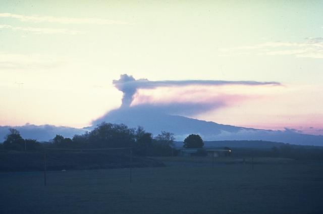
Column of smoke rising from the main crater.A steam plume rising from the historically active summit crater, which has been the site of frequent phreatic and phreatomagmatic eruptions since 1828. Eruptions often include geyser-like ejection of crater lake water. |
A steam plume pours from fumaroles on the pyroclastic cone on the south side of the summit crater lake of Poas volcano in this February 2000 view from the NW. Vigorous degassing produced plumes up to about 700 m high in May, and bubbling of the crater lake had been reported since late March. A temperature of 40�C was measured on the NE shore of the lake at various points in May. The 400-m-wide coldwater lagoon known as Laguna del Frнa or Laguna del Poas is visible at the upper left within Botos maar.Photo by Federico Chavarria Kopper, 2000 http://www.volcano.si.edu/world/volcano.cfm?vnum=1405-04=&volpage=photos |
Minor phreatic eruptions producing geysering to heights of several meters were first reported in March 1994. Two phreatic eruptions were reported at the end of April, by which time the crater lake had nearly dried up. Intense gas emission in the ensuing months caused health problems and severe economic losses in agricultural areas. Ash eruptions that took place on June 3 and July 9 to August 5 formed a small new crater. The crater lake (seen here September 2, 1994) returned, and minor phreatic eruptions took place in October. Photo by Jose Enrique Valverde Sanabria, 1994 (courtesy of Eduardo Malavassi, OVSICORA-UNA).http://www.volcano.si.edu/world/volcano.cfm?vnum=1405-04=&volpage=photos |
Poas stratovolcano, 2708m, erupted intermittently from June 1987 to June 1990, producing ash-bearing plumes such as this one seen on March 6, 1989. Geyser-like phreatic explosions had resumed at Poбs from June 1987 until at least October 1988, punctuated by large explosions on April 9, 1988. The crater lake completely disappeared by April 1989, and during May ash plumes reached heights of 1.5-2 km above the crater. Sulfur-rich fumarolic activity constructed sulfur cones, lakes of molten sulfur, and sulfur flows up to 30 m long. Photo by Gerardo Soto, 1989 (Instituto Costarricense de Electricidad, published in Alvarado, 1989). http://www.volcano.si.edu/world/volcano.cfm?vnum=1405-04=&volpage=photos Poas has been formed from adjoining eruptive centres with large collapse craters. A famous eruption in 1910 sent a water geyser 4000 m into the air. Sulphur eruptions have occurred intermittently at the volcano since 1989. It has erupted 39 times since 1828. 2011 Earthquake: On 13th May 2011 there was a large (magnitude 6.0) earthquake 10 km south of Poas volcano. The focus was at a depth of 70 km.2011 Phreatic Eruption: A small phreatic eruption occurred from a summit lake of Poбs volcano on 2nd February. Material was ejected 6 m high. Bubbles of gas and upwelling sediments were observed from the lake surface.2010 Phreatic eruption: A phreatic explosion occurred at Poas volcano on 23rd February at Laguna Caliente. Sulphurous deposits were ejected onto the southern flank. The event was not preceded by seismic activity.2009 Earthquake and Eruption: A large earthquake (mag 6.1) occurred at Poas volcano on Thursday 8th January 2009. The epicentre was located 8 km east of the volcano summit. A phreatic eruption occurred at the summit lake (Laguna Caliente). The eruption ejected ash and steam 600 m above the lake.2008 Eruption: A small phreatic eruption occurred at the crater lake (Laguna Caliente) on 13th January 2008. Ash was emitted to 2.0 km altitude.2006 Eruptions: On 24th March 2006 eruptions occurred from the bottom of Caliente Lake. Two phreatic eruptions occurred at the crater lake on 25-26 September 2006. A phreatic eruption occurred on 16th December 2006. Erupted material reached a height of 30 m.Poas Eruptions: 2008-2011, 2006, 1996, 1994, 1992-93, 1992, 1991, 1991, 1987-90, 1981, 1980, 1979-80, 1978, 1977-78, 1977, 1976, 1974-75, 1972-73, 1970, 1969, 1967, 1964-65, 1963, 1958-61, 1952-57, 1948-51, 1946, 1941-46, 1929, 1925, 1914-15, 1914, 1910, 1910, 1907, 1898-91, 1880, 1879?, 1860, 1838, 1834, 1828 http://www.volcanolive.com/poas.html |
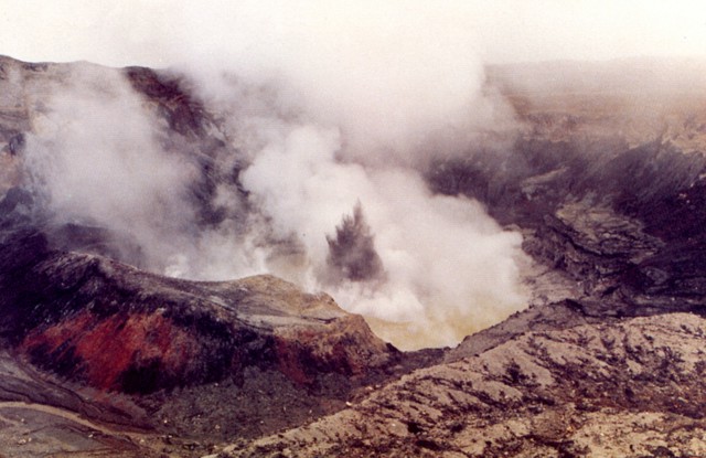
Moderate eruptions with strong vapor and ash emission took place from the main crater of Poas during March to May 1981. This March 19 time exposure from the northern crater rim shows the incandescent wall of a lava dome in the crater. Fumarolic activity continued until 1986.Photo by Eduardo Malavassi, 1981 (OVSICORA-UNA http://www.volcano.si.edu/world/volcano.cfm?vnum=1405-04=&volpage=photos |
An ash plume rises above the crater lake of Poas volcano in 1915. Intermittent eruptions producing some ashfall had begun October 8, 1914, and were continuing on May 15, 1915. The April 10 eruption was seen from San Josй, and the last of a series of eruptions during April 15-19 produced ashfall at great distances. Photo by R. Fernandez Peralta, 1915 (courtesy of Jorge Barquero, Universidad Nacional Costa Rica). http://www.volcano.si.edu/world/volcano.cfm?vnum=1405-04=&volpage=photos |
An ash plume rises above vents in the summit crater of Poas volcano on May 4, 1990, near the end of an eruptive period that began in June 1987. At the time of this photo the crater lake had shrunk substantially to a small feature only several centimeters deep that fluctuated slightly with changes in rainfall recharge. Lake temperatures were >72�C (measured by infrared thermometer), and small hot springs around the lake had temperatures of 85�C. Minor explosive eruptions at Poas continued into the following month.Photo by Jorge Barquero, 1990 (Universidad Nacional Costa Rica). http://www.volcano.si.edu/world/volcano.cfm?vnum=1405-04=&volpage=photos |
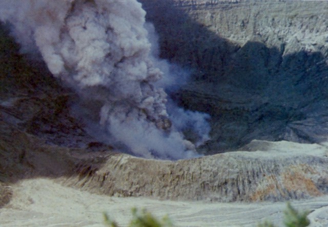
Poas. Volcanic gases and associated condensate and rainfall led to increasing areal extent and degree of damage to vegetation in nearby areas. In studying the Lago Caliente''s waters, Martinez and others (2011) found in solution a variety of oxo-anions of sulfur called polythionates (SnO6-2, where n can be 20 or larger), which they found to vary in concentration from undetectable to 8,000 mg/L. They considered polythionates to be "highly relevant for monitoring purposes at Poas, in particular because they may signal impending phreatic eruptions."More on the 25 December 2009 phreatic eruption. A previous report discussed a phreatic eruption on 25 December 2009 but some further comments are worth adding. As previously noted, "Steam and lake water mixed with sediment and blocks were ejected 550-600 m above Laguna Caliente and fell in the vicinity of the lake, within the crater." No mention was previously made of a 24 December 2009 phreatic eruption discussed by OVSICORI-UNA. It took place in the morning at 0808 and all erupted material fell back in the crater.Photos taken on 25 December 2009 and recently posted on the Picasa website have come to our attention. The four photos on figure 24 come from a set of nine taken from the S rim. The earliest of the set depict a very tranquil lake with steaming at or near the dome (not shown here). The next photo, taken 129 seconds after that tranquil scene, portrays the advancing eruption . The subsequent two photos captured the interval closest to the peak of the eruptive vigor. Four sequential photos taken looking N at Poas of a phreatic eruption from the center of Lago Caliente on 25 December 2009. The time intervals between the four photos was as follows: photos (a) to (b), 5 sec; photos (b) to (c), 5 sec; and photos (c) to (d), 11 sec. Photo descriptions below: (a) The earliest available photo of the eruption cloud, which, based on the next photo in this set, was clearly still emerging energetically. It advanced with the leading portions of the plume chiefly dark. At the plume''s base, white steam clouds mask the lake. (b and c) The shots taken closest to the maximum point of the eruption''s thrust phase, with dark material still conspicuous. White tufts expanded and began to cap most of the advancing jets. The clouds engulfing the base of the plume now contain more discolored zones. (d) As the plume evolves and the vigorous exhalative part of the eruption ends or wanes, a steam-rich cloud envelops the eruption cloud. Note the gray-colored rain falling out of the plume. Taken from Cindy and JM''s Gallery (undated) on the Picasa photo sharing website (see References and Information Contacts below). http://www.volcano.si.edu/reports/bulletin/contents.cfm?issue=3604&display=complete |
Poas. An exact assessment of the photos is complicated by several factors. There were shifts in the focal length of the lens (documented in camera metadata found on the website). Also, in detail, the camera''s time record indicated 0252 hrs, clearly incorrect for this daylight scene. That problem is reconciled by a photo featured in the OVSICORI-UNA report, which showed a plume photo by another photographer at a stage nearly identical to figure 24b and the text indicated the eruption occurred at 0952 hrs local time.An email response from Cindy Doire provided these comments about witnessing the phreatic eruption."We arrived at the volcano early in the morning. We were one of the first to arrive that day. Our group and a few other tourists were looking at it and NOTHING was happening. The people finished looking and started leaving that spot. It was just about 4 of us still there, when suddenly the volcano started to erupt. There was NO warning at all. Even the rangers were surprised. At the beginning, white steam (gas?) shot up, then black rock and dirt started exploding out. I believe that everything that shot up, fell back into the crater . . . the gas could be smelled and was strong �" In an email to GVP regarding the 25 December 2009 eruption, Eliecer Duarte commented: "It seems that this [25 December 2009] eruption opened a more permanent vent at the bottom of the lake. Since that event the frequency of phreatic ones increased and remained like this for [a] year and a half. We still have dozens of smaller ones daily. More on crater degassing. Field visits during 2010 and 2011 allowed scientists to see the expanding effects of Poas volcanic gases on vegetation (figures 25 and 26). Dry conditions resulted in winds carrying the gases considerable distances from the volcano. The area most affected was an elongate zone downwind of the active crater and extending ~4 km SW. Figure 26 portrays transitional zones with intermediate effects. A commercial airline pilot and amateur photographer took this and other photos of Poбs on 28 April 2010. The active crater and its discolored lake (Lago Caliente) reside at the right-hand side of this shot. It is part of an elongate zone of barren rock stretching ~4 km across the otherwise lushly vegetated landscape. As is typical, the plume''s orientation on this day lies directly over the barren zone. http://www.volcano.si.edu/reports/bulletin/contents.cfm?issue=3604&display=complete |
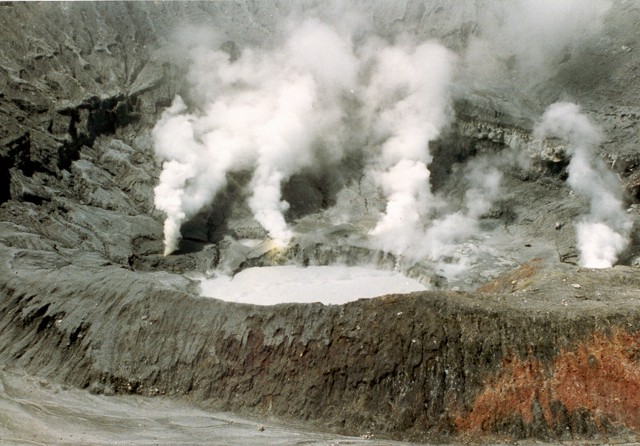
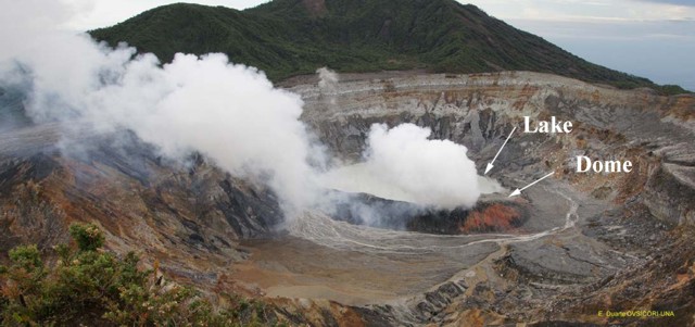
Poas. Starting just beyond the elongate zone of harsh effects, the areas of discolored vegetation had increased impact and areal extent. One such impacted area was a nature preserve called Providencia, which is seen in figure 26 to the left of Poas. Farther from the volcano lies Cerro Pelon (2.5 km distance and direction SW of the crater) , which also showed the effects of chemical burning from volcanic gases.In the past, activity centers have migrated within the crater. OVSICORI-UNA reported that, for at least the past year (ending March 2011), the points of degassing have been concentrated in the hot crater lake and dome. The emanating steam and gases, often carried by wind, have affected areas up to several hundred meters around the crater. The active crater at Poбs, showing pronounced steam release both from fractures in the dome as well as from the lake''s surface. Conditions like this (with more or less steam) often prevailed in recent times (including just a few seconds prior to the eruption sequence shown in figure 24). The crater lake (Lago Caliente) rests behind (N of) the dome and steam clouds. Courtesy E. Duarte, OVSICORI-UNA. http://www.volcano.si.edu/reports/bulletin/contents.cfm?issue=3604&display=complete |
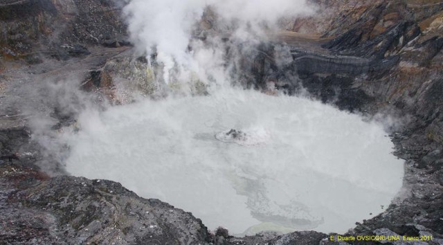
Poas. OVSICORI-UNA reported that through at least March 2011 small phreatic eruptions occurred daily at Lago Caliente. These eruptions sometimes only reached the lake''s surface, but at other times reached a few meters above the lake, and occasionally, tens of meters above the lake. The majority of the erupted sediments fell back into the lake. The fine sediments sometimes remained suspended in the lake water and caused its gray color. The majority of eruptions occurred in the central part of the crater, with a few originating slightly more to the N or S of the center. Because of the phreatic activity and high temperature of the lake (57�C), strong evaporation occurred and plumes traveled long distances in the wind (figure 28). At Poas, a phreatic eruption at Lago Caliente reaching several meters high, in a manner typical of daily activity during recent months. View from the active crater''s N side (opposite the viewpoint). Photo taken sometime in January 2011. Courtesy E. Duarte, OVSICORI-UNA http://www.volcano.si.edu/reports/bulletin/contents.cfm?issue=3604&display=complete |
Ash and mud from a small phreatic explosion rise above the steaming crater lake of Poas volcano on August 28, 1988. Geyser-like phreatic explosions had been occurring since June of the previous year and lasted for a few more months beyond August 1988. Geyser-type activity was almost continuous during the second half of August and the first week of September, with black mud plumes rising 5-10 m. During the rest of the month, plumes rose as much as 25 m. Small mud eruptions continued, and by April 1989 the crater lake disappeared.Photo by E. Valverde, 1988 (published in Barquero, 1998) http://www.volcano.si.edu/world/volcano.cfm?vnum=1405-04=&volpage=photos |
Geyser-like phreatic eruptions resumed from Poas volcano in June 1987, ejecting lake water and sediments to a maximum reported height of 75 m. This January 23, 1988 photo shows the typical ejection of plumes of gas, ash, and mud above the crater lake. The crater lake disappeared by April 19, 1989 and lithic ash emission began. Mud eruptions resumed when rainy-season waters formed a new lake. During May 1989 ash plumes reached heights of 1.5-2 km above the crater. Phreatic eruptions continued until June 1990. http://www.volcano.si.edu/world/volcano.cfm?vnum=1405-04=&volpage=photos |
A dark plume containing ash and mud punches through the surface of the crater lake of Poas volcano in July 1977. Ash-laden plumes rose at 25-minute intervals from the crater lake. Phreatic explosions began in May 1977 and were continuing at the time of this July photograph.Photo by S. Racchini, 1977.A geyser-like ejection of steam and ash rises above the surface of the crater lake of Poas volcano in July 1977. The white ring at the base of the eruption column is a steam cloud that is traveling laterally away from the vent along the surface of the crater lake. Mild phreatic explosions such as this one were typical of an eruption that began in May 1977 and lasted at least until July. The crater walls rise about 250 m above the lake. (Universidad Nacional Costa Rica, courtesy of Jorge Barquero). http://www.volcano.si.edu/world/volcano.cfm?vnum=1405-04=&volpage=photos |
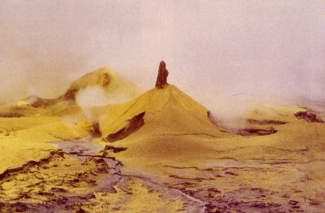
Small mud and sulfur cones up to 3 m high were formed during 1989 on the floor of the active crater. A period of eruptive activity from June 1987 to June 1990 included geyser-like crater lake eruptions, the ejection of mud and pyroclastic sulfur, the formation of temporary small pools of liquid sulfur, and the emission of sulfur lava flows up to 30 m long. Acidic gas plumes caused extensive damage to plantations on the volcano''s flanks.Photo by Jorge Barquero, 1989 (Universidad Nacional Costa Rica). http://www.volcano.si.edu/world/volcano.cfm?vnum=1405-04=&volpage=photos |
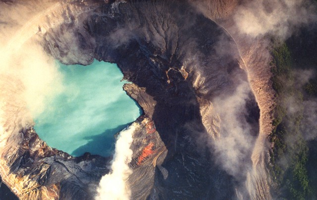
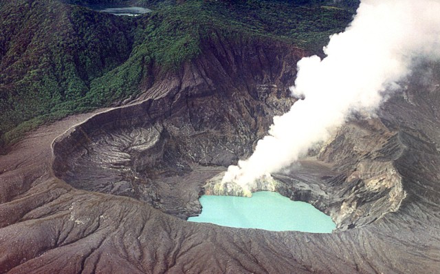
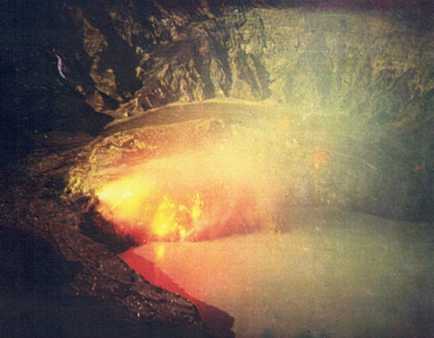
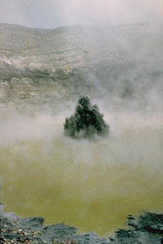
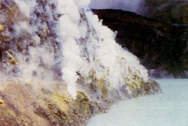
Escaping fumarolic gases pour from the sulfur-lined wall of a lava dome at the bottom of the active crater of Poбs. The water filling the turquoise-colored crater lake is among the most acidic natural waters on Earth (pH = 0). The hot (roughly 50 degrees Centigrade) lake has been the source of frequent phreatic eruptions that produce geyser-like plumes of steam, ash, and mud. Pyroclastic sulfur has also been ejected. Photo by Guillermo Alvarado (Instituto Costarricense de Electricidad. http://www.volcano.si.edu/world/volcano.cfm?vnum=1405-04=&volpage=photos |
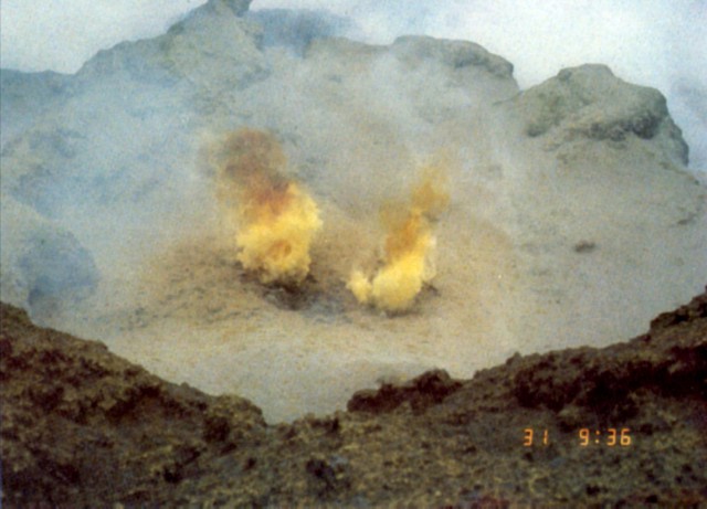
Fumarolic plumes at Poas volcano are sometimes tinted yellow by the high-temperature combustion of sulfur. Pyroclastic scoriaceous sulfur fragments have been ejected during some explosive eruptions. Acidic gas plumes from Poбs have damaged vegetation in the national park and surrounding areas, causing widespread devastation to coffee and other plantation crops. An explosion on April 9, 1988 dropped acidic sulfur-rich mud on visitors, cars, and plants near the tourist overlook.Photo by Jorge Barquero (Universidad Nacional Costa Rica). http://www.volcano.si.edu/world/volcano.cfm?vnum=1405-04=&volpage=photos |
Brilliantly colored sulfur and other minerals precipitate around high-temperature fumaroles in the summit crater of Poas volcano. Fumarolic temperatures approaching 600 degrees Centigrade were recorded in 1988, several times higher than the melting point of sulfur. The ejection of pyroclastic material consisting of scoriaceous sulfur resembling basaltic scoria as well as the emission of small sulfur lava flows has been documented during several historical eruptions at Poas. Photo by Jorge Barquero (Universidad Nacional Costa Rica). http://www.volcano.si.edu/world/volcano.cfm?vnum=1405-04=&volpage=photos |
Geologic Summary. The broad, well-vegetated edifice of Poas, one of the most active volcanoes of Costa Rica, contains three craters along a N-S line. The frequently visited multi-hued summit crater lakes of the basaltic-to-dacitic volcano, which is one of Costa Rica''s most prominent natural landmarks, are easily accessible by vehicle from the nearby capital city of San Josй. A N-S-trending fissure cutting the 2,708-m-high complex stratovolcano extends to the lower northern flank, where it has produced the Congo stratovolcano and several lake-filled maars. The southernmost of the two summit crater lakes, Botos, is cold and clear and last erupted about 7,500 years ago. The more prominent geothermally heated northern lake, Laguna Caliente, is one of the world''s most acidic natural lakes, with a pH of near zero. It has been the site of frequent phreatic and phreatomagmatic eruptions since the first historical eruption was reported in 1828. Poas eruptions often include geyser-like ejections of crater-lake water. http://www.volcano.si.edu/reports/bulletin/contents.cfm?issue=3604&display=complete Botos cone forms the 2708 m high point of the Poas volcanic massif. It was the eruptive focus prior to about 7500 years ago, when that focus shifted to the presently active crater (which lies beneath the clouds to the NW). The 1-km-wide Botos maar is filled by a 400-m-wide coldwater lagoon sometimes known as Laguna del Frнa or Laguna del Poбs. The lake has a maximum depth of 14 m. The cold, freshwater lagoon contrasts with the hot, extremely acidic lake of the main crater. Poas is situated near the southeastern end of the Central American arc, above the Cocos-Caribbean subduction zone. Cinder cones are strongly aligned in a north-south direction. Two calderas, one nested within the other, developed in the summit area of Poas (Thorpe and others, 1981). The younger, smaller collapse occurred less than 40,000 years B.P. but more than 7,540 years ago (a carbon-14 date on the postcaldera Botos cone) (Prosser, 1983, 1985; Prosser and Carr, 1987). The modern cone of Poas has grown within and nearly obscured the two calderas; only the flat-topped morphology of Poas belies its calderas. The summit of the modern cone has a main crater that may contain a sulfur-rich lake with a layer of molten sulfur at its base (Bennett and Raccichini, 1978; Francis and others, 1980). The magma erupted to form the younger caldera has been tentatively identified as basaltic andesite (Prosser and Carr, 1987); magma associated with the earlier caldera-forming eruption is not known. A mafic composition is consistent with the lack of a major gravity low in the area of the caldera and the existence of a local gravity high at Poas''s summit. Tournon (1984) presented analyses of basalt, andesite, and low-silica dacite -- samples that may span the time(s) of caldera formation. Most historical eruptions of Poas have been small, phreatic or magmatic, sometimes including molten sulfur. From: Dzurisin and Newhall, 1988, Historical Unrest at large Calderas of the World: USGS Bulletin 1855 http://vulcan.wr.usgs.gov/Volcanoes/CostaRica/description_costa_rica_volcanoes.html |
Poas is multicratered cone. Its summit is often enveloped in clouds. The active crater has an acid lake and a lot of fumarolic activity. Phreatic explosions occasionally occur as well as rarer pyroclastic activity. The crater is situated in one of Costa Rica''s most modern national parks. short distance from the main crater is Lago Bodos, a cold water lake found in an older crater. The water appears to be very fresh; no fumarolic activity is seen here -http://www2.brevard.edu/reynoljh/costarica/2003/crvolcanoes.htm |
Lake Botos |
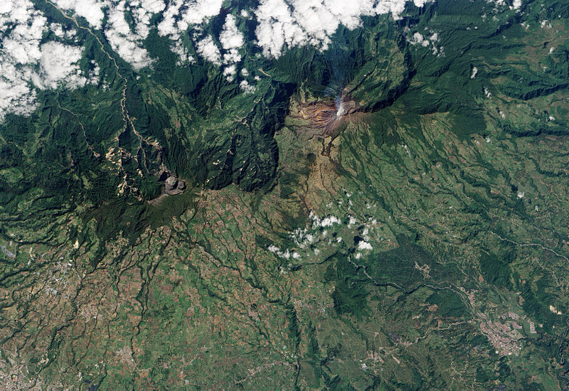
The Laguna Rio Cuarto maar occupies the northern end of a chain of volcanic vents extending to about 18 km north of Poas volcano. The 600 x 750 m wide maar has a maximum depth of 66 m and is bounded by low walls that rise only 4-20 m above the lake surface. The maar was erupted through lahar and alluvial deposits on the coastal plain at an elevation of only about 400 m above sea level.Photo by Paul Kimberly, 1998 (Smithsonian Institution) http://www.volcano.si.edu/world/volcano.cfm?vnum=1405-04=&volpage=photos |
Bosque Alegre maar was constructed about 12 km from Poas along a N-trending chain of vents. Laguna Hule ("Rubber Lake") at the lower left lies within the 2-km-wide maar complex known as Bosque Alegre ("Happy Forest"). The pyroclastic cone at the right rises about 130 m above the roughly 20-m-deep lake and separates it from Laguna Congo in the NW part of the maar complex. A pyroclastic-flow deposit from Bosque Alegre maar was radiocarbon dated at about 2730 yrs before present.Photo by Guillermo Alvarado, 1987 (Instituto Costarricense de Electricidad).http://www.volcano.si.edu/world/volcano.cfm?vnum=1405-04=&volpage=photos |
An aerial view from the north looks down the chain of vents extending north from Poas volcano. In the foreground is the Bosque Alegre (Laguna Hule) maar complex, and the forested peak in the middle distance is Cerro Congo volcano. Poбs volcano forms the horizon, about 12 km to the south. The Bosque Alegre complex contains three lagoons, Laguna Congo (lower right), a small unnamed one above it, and Laguna Hule (left center). The 2-km-wide complex last erupted about 2730 years ago. Photo by Guillermo Alvarado, 1987 (Instituto Costarricense de Electricidad).http://www.volcano.si.edu/world/volcano.cfm?vnum=1405-04=&volpage=photos |
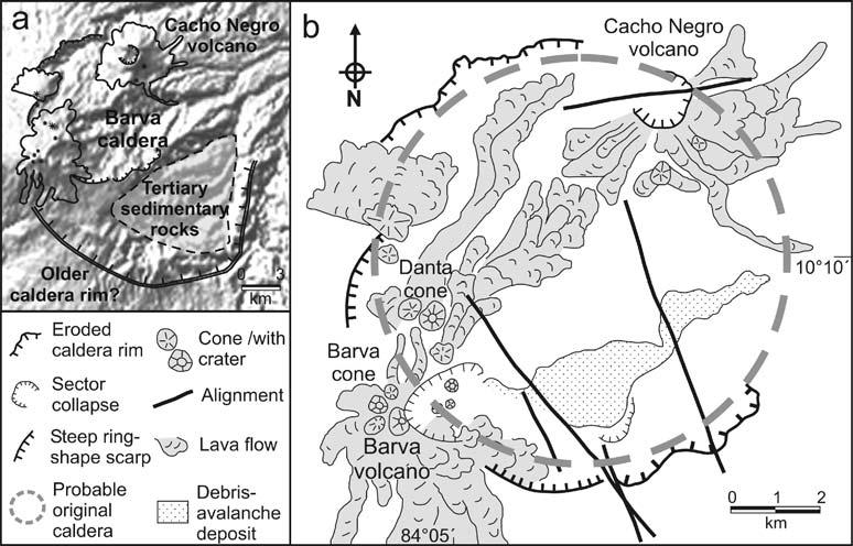
Barva Volcano is a composite, dormant, andesitic shield volcano. The volcano contains a complex form with many craters and parasitic cones. There is a 800 m wide crater near the summit which contains a lake.Calderas: Barva volcano covers an area of 1,500 sq km and has two major calderas. Barva caldera is 10 km in diameter, with a rim 140�320 m above the floor. The rim is eroded in the east and northeast. The second caldera structure is 15 km in diameter, and older than Barva caldera based on the degree of erosion. The rim of this caldera is open to the NE and the eastern rim is affected by faulting. Tiribi Tuff: The caldera-forming eruption of Tiribi Tuff 322,000 years ago, is the most explosive event recorded in Costa Rica. Barva volcano has been identified as the source of the Tirib� Tuff. The Tirib� Tuff comprises pyroclastic deposits that crop out in the lower SW flanks of Barva volcano. It is the most widespread, recent and well exposed ignimbrite in central Costa Rica. It has a volume of 25 cubic km, and covers an area of 820 sq km. The thickness of the upper ash-flow sheet is about 100 m (average 30 m).The Tiribi Tuff eruption highlights the danger posed by Barva volcano to the 2.4 million people living around the volcano.Possible eruption of Barva Volcano in 1867 http://www.volcanolive.com/costarica.html |
Barva caldera http://www.geo.mtu.edu/~raman/papers2/The%20Tiribi%20Tuff.pdf |
http://www.geo.mtu.edu/~raman/papers2/The%20Tiribi%20Tuff.pdf |
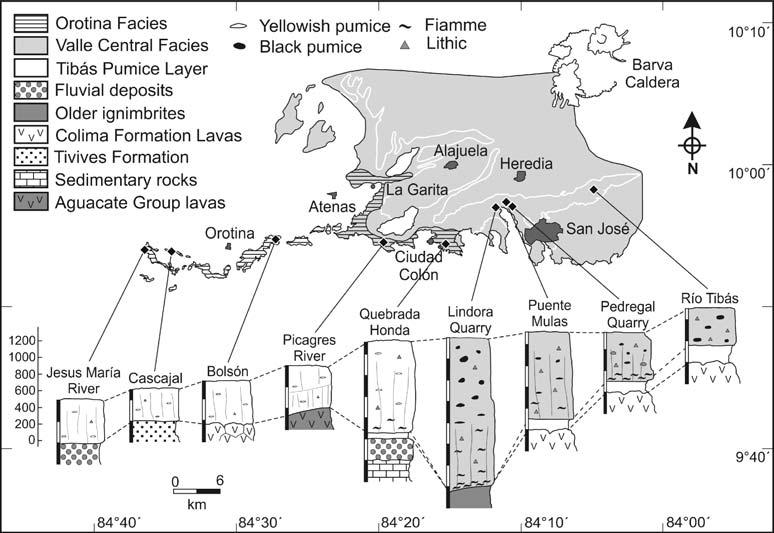
Distribution of the 322 KA Tiribi tuff(Valle Central and Orotina) http://www.geo.mtu.edu/~raman/papers2/The%20Tiribi%20Tuff.pdf |
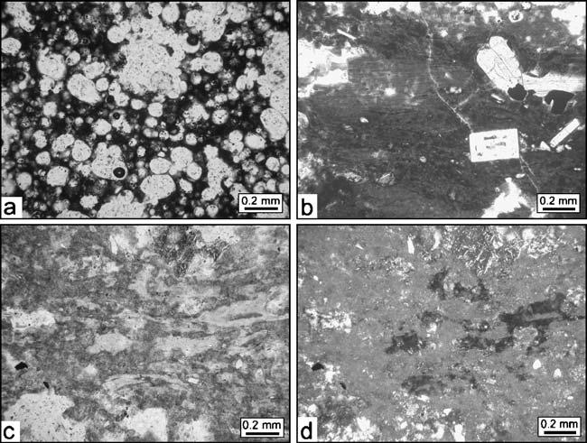
Microscopic photographs of the 322KA Tiribi Tuff facies. a Highly vesicular black pumice of the non-welded portions of the Valle Central facies, showing abundant small spheric vesicles, b Densely welded portion of an ignimbrite of the Valle Central facies at the Electriona Power Plant (eastern Valle Central). The rock is a vitrophyre of fresh dark brown glass and euhedral plagioclase and clinopyroxene crystals. c Devitrified ignimbrite of the Orotina facies, showing still fresh glass shards surrounded by a devitrified groundmass altered to sericite and microcrystalline quartz.d Same sample as c but with crossed polarized light http://www.geo.mtu.edu/~raman/papers2/The%20Tiribi%20Tuff.pdf |
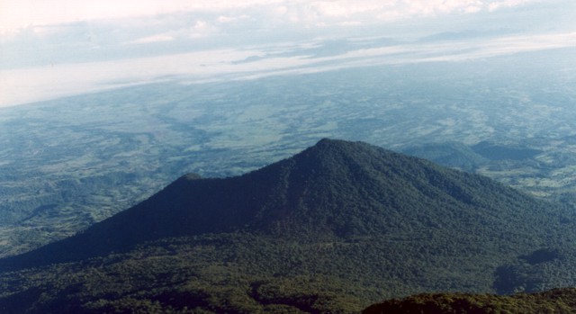
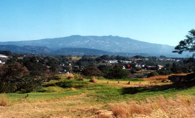
Barva, 2906m, last eruption 6050 BC.Barva volcano rises to the NE above the western outskirts of San Jose. No confirmed historical eruptions are known from Barva, but thermal springs are found near Porrosati de Barva, Gongolona peak, and along ridges to the north side of the volcano. Sulfur vapor and mineral deposition occurs at landslide scarps on the flanks of the volcano.Volcan Barva seen here from the Central Valley of Costa Rica, is a complex volcano with a broad summit containing three principal peaks and a dozen eruptive vents. Four pyroclastic cones are constructed within the central and NW parts of a 2 x 3 km caldera. The SW peak is capped by another 4 cones, one of which contains a crater lake. Satellitic cones are found on the northern and southern flanks. A large plinian eruption occurred at Barva during the early Holocene. There have been no confirmed historical eruptions. The massive Barva volcano is dotted with numerous satellitic vents, some of which are visible along the irregular northern horizon. Multiple lava flows descend the southern flank of Barva. One of the more recent of these is the Los Angeles flow, which reaches nearly to the city of Heredia. http://www.volcano.si.edu/world/volcano.cfm?vnum=1405-05=&volpage=photos |
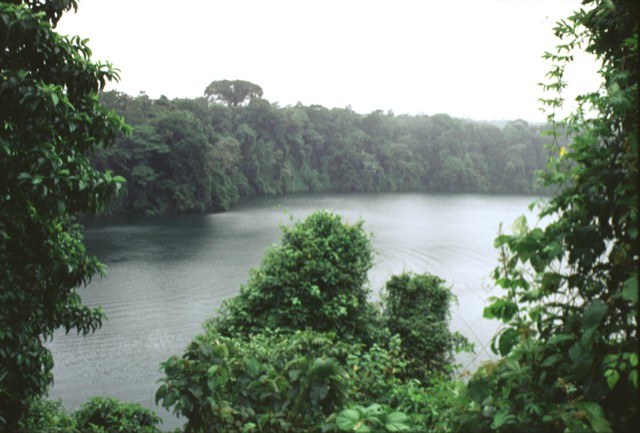
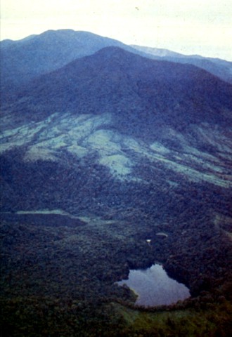
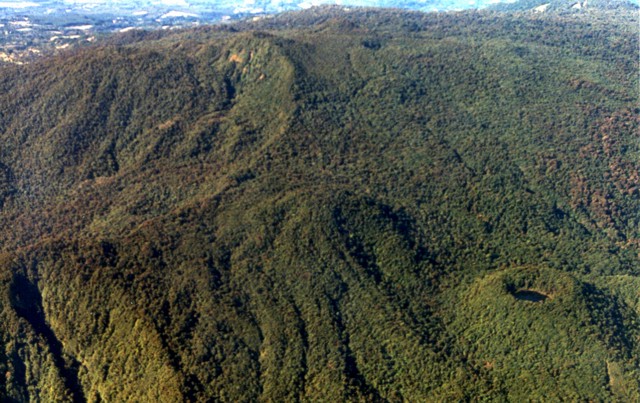
The forested summit area of Volcan Barva is composed of a series of overlapping cones with about a dozen vents. At the lower right is the well-preserved cone of Danta (whose name means tapir), with a small lake in its crater. Forest-covered lava flows can be seen to its left. Barva is the topographic high point of Braulio Carillo National Park, noted for its lush forests and exotic birds and wildlife.Photo by Federico Chavarria Kopper, 1999 (courtesy of Eduardo Malavassi, OVSICORI-UNA).http://www.volcano.si.edu/world/volcano.cfm?vnum=1405-05=&volpage=photos |
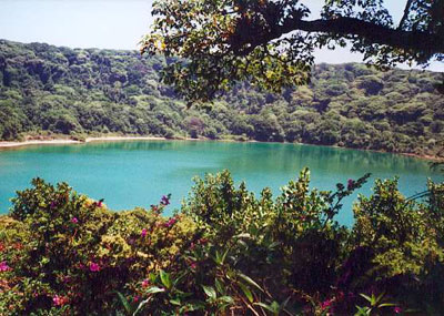
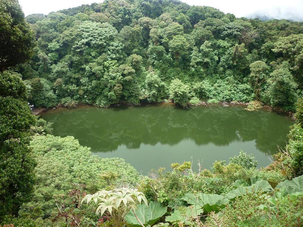
The SW peak of Barva volcano is capped by at least four volcanic cones. This 2840-m-high cone contains a well-preserved crater filled by the 70-m-wide Barva lagoon. Aztec legends tell of the formation of Barva lagoon and a fearful serpent that devoured children in a nearby village. Nineteenth-century visitors to Barva lagoon noted similar dense vegetation as seen today, discounting reports of earlier historical eruptions |
Barva Volcano, is an inactive volcano; on the Eastern side of the mountain it has a lake in what formerly was the volcanic crater, called "Laguna de Barva", and in the Western side it has three hills on the top which are called "Las Tres Marias"[. It is an andesitic shield complex in central Costa Rica. Barva has a dozen different erruptive spots in the summit and some parasitic cones in the flanks of the mountain. Its three principal summits visible from the Central Valley give it the common local name of Las Tres Marias. Four pyroclastic cones are constructed within the 2 x 3 km caldera at the central and NW part of the summit. The SW peak contains four cones, one of which has a crater lake.The volcano has not presented any erruptive activity since colonial times. Eruptions were reported around 1760 but later visits to the summit did not provide evidence of eruptions during historical time. http://en.wikipedia.org/wiki/Barva_Volcano |
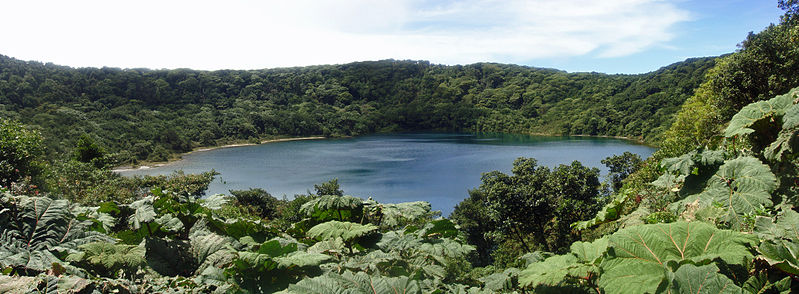
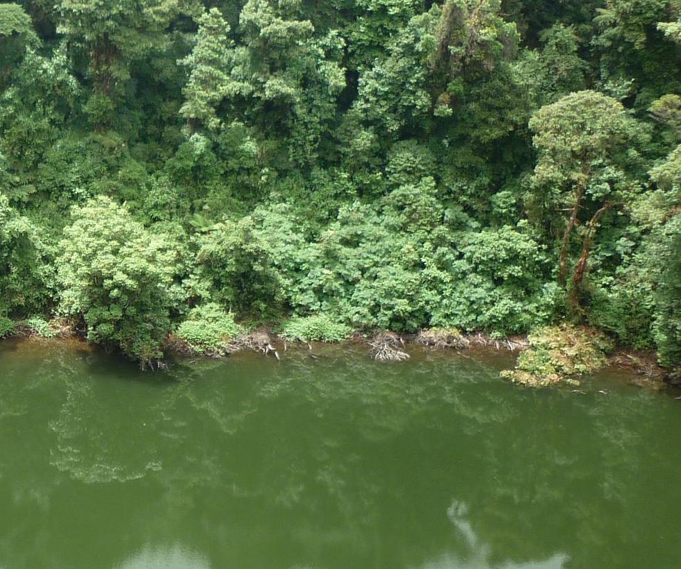
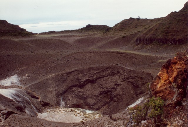
The roughly 300-m-wide Barva crater lake is surrounded by dense forest. The clear waters of the shallow lake are about 8 m deep, and a pH of 4-5 was measured in December 2002. Near-surface black lapilli deposits were found that were more than a meter thick near the lake. |
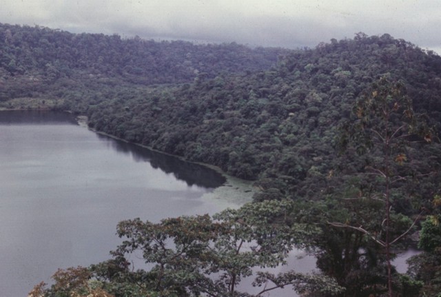
The southern flanks of Barva volcano lie in the foreground of this photo, with the flat-topped Irazu massif in the background to the SE. One of the youngest lava flows on Barva, the Los Angeles flow, traveled down the south flank almost as far as the city of Heredia. Barva and Irazъ, Costa Rica''s highest volcano, form backdrops to the nation''s capital city, San Jose, which lies out of view to the right. Irazъ is sometimes known as the "Colossus" due to its massive size and occasionally destructive eruptions.Photo by Ichio Moriya (Kanazawa University).http://www.volcano.si.edu/world/volcano.cfm?vnum=1405-05=&volpage=photos |
Irazu and Turrialba |
A group of scoria cones lies on the southern flank of Irazu near the road to the summit. Many of these cones were constructed along a NNW-SSE trend. Flank cones were the source of voluminous lava flows such as the compound roughly 1.2 cu km Cervantes flow, which traveled about 10 km down the SSE flank to the Rнo Reventazon at the base of the volcano.Photo by Ichio Moriya (Kanazawa University).http://www.volcano.si.edu/world/volcano.cfm?vnum=1405-06=&volpage=photos |
Hummocky terrain on the south flank of Irazъ marks the path of the Cervantes lava flow. This massive compound flow originated from two vents, Cerro Pasquн and another to the NW, producing the eastern and western Cervantes flows, respectively. The former traveled about 10 km to the base of the volcano. These flows are chemically bimodal, with the 0.17 cu km western flow being basaltic in composition and the 0.9 cu km eastern flow basaltic andesite. Radiocarbon ages for the flow range between about 14 and 17KA. Photo by Guillermo Alvarado, 1986 (Instituto Costarricense de Electricidad).http://www.volcano.si.edu/world/volcano.cfm?vnum=1405-06=&volpage=photos |
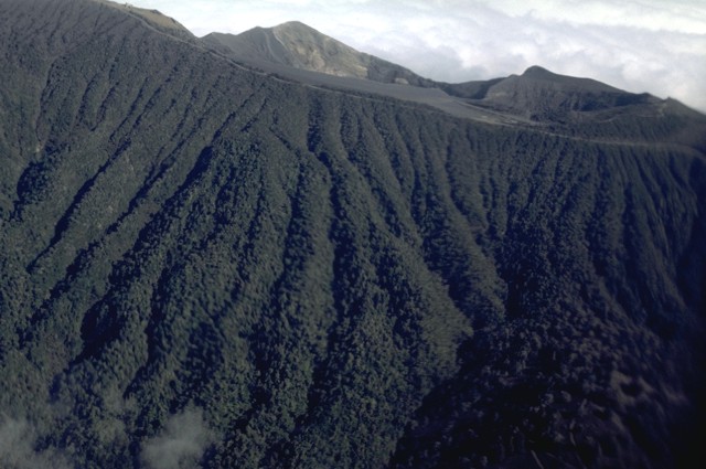
Erosional ribs furrow the upper southern flanks of Irazu volcano. The summit of the volcano lies just out of view at the upper right. The flat bench is Playa Hermosa. Behind it to the left is the northern rim of Irazъ''s currently active summit crater. To the right is the northern rim of the older Diego de la Haya crater, source of eruptions during the 18th century. Volcanism at Irazъ has migrated from east to west; a still older cone lies out of view to the right. Photo by William Melson, 1986 (Smithsonian Institution). http://www.volcano.si.edu/world/volcano.cfm?vnum=1405-06=&volpage=photos |
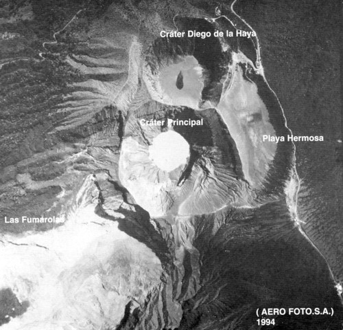
The summit crater complex of Irazu volcano is seen in this aerial view with north to the left. Eruptive activity at Irazъ has migrated to the west from a crater out of view beyond the top of the photo to the Diego de la Haya crater (active during the 19th century) and then to the main crater (Crбter Principal). Playa Hermosa is a largely buried older crater. The road at the right leads to communication towers at the summit of Irazъ (lower right).Aerofoto S. A., 1994 (published in Barquero, 1998).http://www.volcano.si.edu/world/volcano.cfm?vnum=1405-06=&volpage=photos |
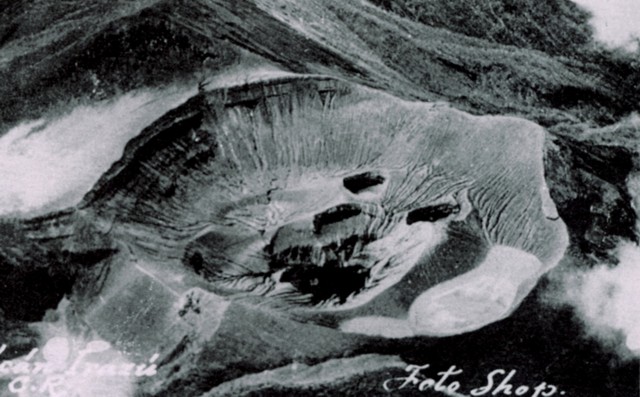
An aerial view shows the summit crater of Irazu volcano prior to the 1963 eruption, with the Diego de la Haya crater at the lower left and Playa Hermosa at the left-center. The floor of the main crater (Crбter Principal) is pocked by several small explosion craters. The ridge on the right side of the crater floor is the remnant of the pyroclastic cone formed during the 1723 eruption. Repeated explosive eruptions during 1963-65 greatly modified the summit crater, and the individual vents seen here were merged into a single large crater.Anonymous photo (published in Alvarado, 1989).The flat bench is Playa Hermosa, a largely filled older crater. The roughly 200-m-deep summit crater has been the source of most of Irazu''s historical eruptions, 600-m-wide crater. http://www.volcano.si.edu/world/volcano.cfm?vnum=1405-06=&volpage=photos |
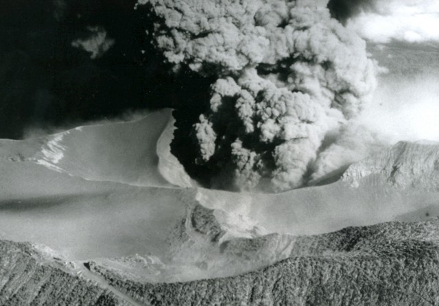
A dense ash plume pours from the summit crater of Irazu volcano on April 14, 1964, about midway through a major explosive eruption that began in 1963. The ash-covered plateau at the left is Playa Hermosa, a buried older crater. The road to the summit of Irazu can be seen at the lower left. Heavy ashfall from the 1963-65 eruption blanketed the Central Valley and caused major economic disruption. The eruption merged several pre-existing smaller craters and increased the diameter of the vent to form the larger present-day crater. Photo by U.S. Geological Survey, 1964.http://www.volcano.si.edu/world/volcano.cfm?vnum=1405-06=&volpage=photos |
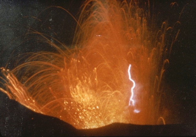
A lightning bolt is visible within incandescent ejecta from the summit crater of Irazu volcano in 1963. This eruption was the largest at Irazъ during the 20th century. Intermittent ejection of ash, lapilli, blocks, and bombs, took place for two years beginning in March 1963. Late in 1963 an eruption column rose to 8 km above the vent in 4 minutes. Incandescent material in the eruption column was common in December 1963 and January 1964. The traces of incandescent bombs ejected by strombolian explosions during the 1963-65 eruption produced spectacular vistas readily accessible to visitors from San Jose. Particularly impressive strombolian activity occurred in December 1963 and January 1964. Photo by M. Esquivel, 1963 (published in Barquero, 1998). http://www.volcano.si.edu/world/volcano.cfm?vnum=1405-06=&volpage=photos |
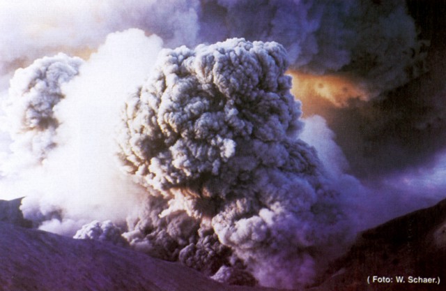
Ashfall from the 1963-65 eruption of Irazu affected both populated areas and agricultural lands. In the weeks following the beginning of the eruption on March 13, 1963 dense ashfall at times restricted visibility to 30 m in San Jose, paralyzing traffic. Remobilization of the heavy ash blanket during the rainy season caused mudflows. During the first weeks of January 1964 heavy ashfall was distributed by winds as far away as Tamarindo beach on the Pacific coast and Lake Nicaragua, 180 km NE of the volcano. The first of several major eruptions of Irazu volcano between 1963 and 1965 took place on March 13, 1963. These eruptions produced heavy ashfall over much of central Costa Rica, severely affecting agricultural areas and causing major economic problems. Photo by W. Schaer (published in Barquero, 1998).http://www.volcano.si.edu/world/volcano.cfm?vnum=1405-06=&volpage=photos |
An eruption plume rising above the summit of Irazu volcano is seen in March 1963 from the old San Jose airport. Eruptions during 1963-65 were among the largest in historical time from Irazъ. Intermittent mild-to-moderate explosive activity produced heavy ashfall that severely affected agricultural areas and caused economic disruption. The largest explosions took place on March 13 and July 3, 1963, January 14, April 14, and July 6, 1964, and January 31, 1965.Copyrighted photo by Dick Stoiber, 1963 (Dartmouth College). http://www.volcano.si.edu/world/volcano.cfm?vnum=1405-06=&volpage=photos |
The light-colored, flat-bottomed floor of the Playa Hermosa crater is truncated by two younger craters--Irazu''s main crater (center) and the Diego de la Haya crater (top left). A greenish lake fills the bottom of the main crater, the source of most of Irazu''s historical eruptions. Diego de la Haya was active during the 18th century. An eruption in 1994 took place from vents below the cliff in the shadow at the lower right. Communication towers line the summit ridge of Irazъ at the upper right. Photo by Federico Chavarria Kopper, 1999. http://www.volcano.si.edu/world/volcano.cfm?vnum=1405-06=&volpage=photos |
Irazu one of its most active volcano rises to 3432 m immediately east of the capital city of San Josй. The massive volcano covers an area of 500 sq km and is vegetated to within a few hundred meters of its broad flat-topped summit crater complex. At least 10 satellitic cones are located on the southern flank of Irazu. No lava flows have been identified from Irazъ since the eruption of the massive Cervantes lava flows from south-flank vents about 14,000 years ago, and all known Holocene eruptions have been explosive. The focus of eruptions at the summit crater complex has migrated to the west towards the historically active crater, which contains a small lake of variable size and color. Although eruptions may have occurred around the time of the Spanish conquest, the first well-documented historical eruption occurred in 1723, and frequent explosive eruptions have occurred since. Ashfall from the last major eruption of Irazu during 1963-65 caused significant disruption to San Jose and surrounding areas. lake occupies one of the summit craters of Irazъ, one of Costa Rica''s most active volcanoes. Irazu rises to 3432 m immediately east of San Jose and is the country''s highest volcano. This crater lake (seen here from the southern crater rim) has been the source of many historical eruptions. The first well documented historical eruption of Irazъ occurred in 1723, and frequent explosive eruptions have occurred since. Ashfall from its last major eruption during 1963-65 caused significant disruption to San Jose and surrounding areas. A panoramic view from the summit of Irazъ volcano shows the E-W-trending summit crater complex. The main crater is partially filled by a lake in the center of the photo, the floor of the broad flat-bottomed Playa Hermosa crater at the right is covered by deposits of historical eruptions, and the Diego de la Haya crater lies in the right background. Photo by Ichio Moriya (Kanazawa University). http://www.volcano.si.edu/world/volcano.cfm?vnum=1405-06=&volpage=photos |
An aerial view from the SE looks down on the summit crater complex of Irazu volcano. A greenish lake fills the 700-m-wide main crater (center), which truncates both the Diego de la Haya crater (lower right) and the older Playa Hermosa crater (lower left), reached by the summit highway. Photo by Federico Chavarria Kopper, 1999. http://www.volcano.si.edu/world/volcano.cfm?vnum=1405-06=&volpage=photos |
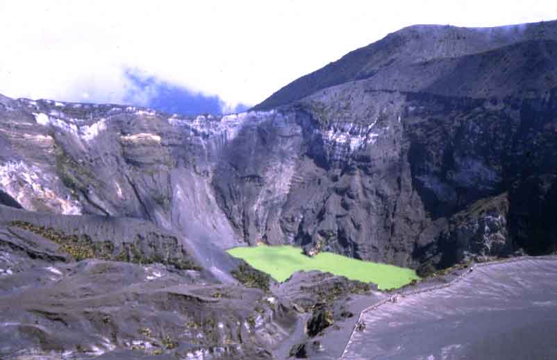
The color of the lake in the summit crater of Irazu volcano varies with atmospheric conditions. The steep-walled crater is about 700 m wide and nearly 200 m deep and has been the source of most of Irazu''s historical eruptions. Fumarolic activity is frequently observed along the shores of the lake, producing bubbling water. A lake occupies one of the summit craters. A lake fills the bottom of the currently active main crater (Crater Principal), which partially truncates the older Diego de la Haya crater . The latter has not erupted since the 18th century. The main crater is about 700 m wide and 200 m deep. It is seen here from the summit of Irazъ, with ash-covered Playa Hermosa (a largely buried older crater) at the lower right and the edge of Diego de la Haya crater at the upper right. Activity at Irazu has migrated to the west from La Laguna, a crater east of Diego de la Haya, to the currently active lake-filled main crater. |
Volcan Irazu erupted several times during the 20th century. A green, acid lake currently occupies the main crater. For scale, several people can be seen along the fence line in the foreground.The Irazu, 3432 m, is an active complex stratovolcanosituated in the Cordillera Central, last eruption 1994.The volcano''s summit has several craters, one of which contains Diego de la Haya, a green crater lake of variable depth. From the top it is possible to see both the Atlantic and Pacific Oceans on a clear day. However, such clear days are very rare indeed, and it is typical for the volcano''s summit to be covered in cloud for much of the time. The volcano is a complex volcanic shield. It has an irregular subconic shape, and its temperature oscillates between 3 and 17 �C . It is a stratovolcano with a summit elevation of 3,432 metres . Its five craters are easily differentiated. The most important ones, because of their activity, are The Main Crater, which is almost circular has very inclined walls and it measures 1,050 m in diameter and 300 m depth; The Diego de la Haya crater is 600 m in diameter and 100 m deep. Other craters are Playa Hermosa, La Laguna, and El Piroclastico. Irazu is the southernmost of the ten Quaternary volcanoes which form a northwest-trending line through central and northern Costa Rica. Radioactive dating has shown an age of at least 854 KYs with eruption peaks at 570 KY and the most recent active phase from 136 KY to present. The most recent activity includes lava flows along with strombolian and phreatomagmatic explosions. Lava types include basalt and andesite erupted during different events suggesting the volcano is fed by two distinct magma chambers. Irazu has erupted frequently in historical times � at least 23 times since its first historically recorded eruption in 1723. Its most famous recent eruption began March 19, 1963 (continuing until 1965). It showered San Jose and much of the central highlands of Costa Rica with ash. http://en.wikipedia.org/wiki/Iraz%C3%BA_Volcano In a Strombolian-type eruption observed during the 1965 activity of Irazu Volcano in Costa Rica, huge clots of molten lava burst from the summit crater to form luminous arcs through the sky. Collecting on the flanks of the cone, lava clots combined to stream down the slopes in fiery rivulets http://vulcan.wr.usgs.gov/Volcanoes/CostaRica/description_costa_rica_volcanoes.html |
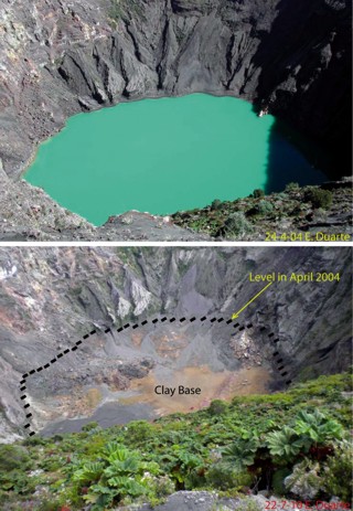
Views taken from Irazu;''s S rim. (top) The crater on 24 April 2004 contained a turquoise lake. (bottom) A repeat photo taken on 22 July 2010 shows the lake had disappeared; the former lake level and the clay base on the crater floor are marked. Since November 2010 water had accumulated and as of April 2011, was several meters deep. Courtesy of Eliecer Duarte, OVSICORI-UNA.http://www.volcano.si.edu/reports/bulletin/contents.cfm?issue=3604&display=complete |
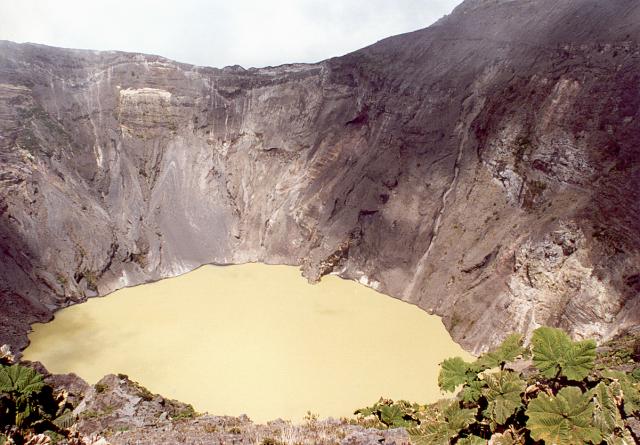
Volcano Irazu The highest volcano in the country. It''s possible to see both oceans at once. On its slopes there are strawberry cultivations. There is a smell of sulphur on its top.Its main crater is round shaped and is filled with green water with sulphur and measures 1050 metres of wide and 300 metres of depth. The second crater Diego da la Haya has 600 metres of width and 100 metres of depth. The other craters are: Playa Hermosa, El Piroklastico and La Laguna. The name Irazu (Iztaru) derives from the language of Indians which used to live under its slopes. It means "a thunder" or "the place that shakes".In April 2010 the lake within Irazu''s crater dwindled to only a few centimeters depth and from May to August the lake was dry enough to allow plants to grow up to 10 cm high. Water began to accumulate in September 2010 but disappeared again during the following month. Since November 2010 water returned to the crater and as late as April 2011, a shallow turquoise-blue lake was maintained. Continuous monitoring of acid rain on Irazu''s flanks reflected contributions from Turrialba. Often called Irazъ''s "twin volcano," Turrialba is less than 10 km to the ENE and during the past 4 years it has caused a region-wide increase in acid rain. Covering January 2004 through September 2007, the last Bulletin report on Irazъ (BGVN 32:11) highlighted decreasing lake levels, fumarolic changes, and minor mass wasting on the crater walls during January 2004 to March 2007 (see table 5 for a summary of lake changes). On 22 July 2010 a team of investigators from Observatorio Vulcanologico Sismologica de Costa Rica-Universidad Nacional (OVSICORI-UNA) descended to the dry crater floor. They documented changes in vegetation, fumaroles, and clay deposition on the crater floor. Photos taken during prior trips provided comparisons with previous conditions (figure 22). Rockfalls and minor mass wasting had been occurring regularly and the long runout of debris across the crater floor was visible during this investigation. Most of the debris fell from the E and SW walls. On the NE side of the dry crater a rocky area emitted low temperature (24�C) sulfur-smelling gases from three aligned vents. Higher temperatures (86�C) were measured from fumaroles on the N side of the crater but they appeared to be releasing gas with less energy than observed in the past years when bubbles were visible within the lake. Another interesting finding was a waterfall on the inside of the crater on the SW wall; this small waterfall did not have sufficient volume to pool on the crater floor and instead soaked directly into the surrounding clay. The water level in Irazъ''s crater has been variable throughout time; the Bulletin recorded a dry crater during February 1977 and June 1987 (SEAN 12:07), and April 1990 (BGVN 15:04). Factors highlighted during the IAVCEI CVL-7 ("Commission of Volcanic Lakes" Costa Rica, 10-19 March 2010) included complex connections with Turrialba, seasonal effects, infiltration within the crater, and the role of mass wasting. The mechanism for the recent disappearance of the lake is still under investigation by OVSICORI-UNA and ICE investigators (Guillermo Alvarado, personal communication). Erosion. Mass wasting had been an ongoing process for at least 10 years. Material is primarily shed from the E and SW walls and the lake contained islands of black and red material formed from the debris. In February 2003 a major rockslide into the lake caused the water color to change from green to shades of red. An analysis of seismicity during that month showed no correlation to these slope failures (BGVN 28:12). Cracks along the NW rim formed and widened since December 2007; these cracks caused blocks up to 3 x 20 m to fall from the rim in March 2008.Local gas measurements. Since the large phreatic explosion in December 1994 (BGVN 19:12), the NW fumarole has been releasing low gas emissions regularly. Different temperature measurements recorded since June 2010 ranged between 90�C to 86�C. To monitor changes in sulfur dioxide output from Irazu, a network of three stations collected rain samples from sites along the volcano''s flanks.The pH data from September 2004 through July 2010 were plotted in the OVSICORI-UNA July 2010 monthly report. The results correlate pH changes to much larger degassing events occurring at Turrialba, a neighboring volcano that began major degassing in 2007. Only the "Borde Sur" station was sampling continuously but the other two stations reflected similar trends in acidity. Despite irregular fluctuations, a decreasing pH trend began in 2007. The lowest point of the trend was measured by "Borde Este" at approximately pH 3.25. Where there "Pacayas" station data began, the trend appeared to have stabilized between pH 3.25 and 4.75.Geological Summary. Irazu, Costa Rica''s highest volcano and one of its most active, rises to 3,432 m immediately east of the capital city of San Jose. The massive volcano covers an area of 500 sq km and is vegetated to within a few hundred meters of its broad flat-topped summit crater complex. At least 10 satellitic cones are located on the southern flank of Irazъ. No lava flows have been identified from Irazu since the eruption of the massive Cervantes lava flows from S-flank vents about 14,000 years ago and all known Holocene eruptions have been explosive. The focus of eruptions at the summit crater complex has migrated to the W toward the historically active crater which contains a small lake of variable size and color. Although eruptions may have occurred around the time of the Spanish conquest, the first well-documented historical eruption occurred in 1723 and frequent explosive eruptions have occurred since. Ashfall from the last major eruption of Irazu during 1963-65 caused significant disruption to San Jose and surrounding areas.http://www.volcano.si.edu/reports/bulletin/contents.cfm?issue=3604&display=complete |
|
Frequent historical eruptions have kept the summit craters of Irazu volcano devoid of vegetation. The thick layer of dark-gray ash and scoria that caps the rim at the left center in this photo marks ashfall deposits formed during the 1963-65 eruptions of Irazu, which were among the largest from the volcano in historical time. A detail of the crater edge. 9.97 N, 83.85 W , summit elevation 3432 m , stratovolcano. 1994 Eruption: A small phreatic eruption occurred at Irazu volcano on 8th December 1994 fumarole on the upper NW-flank. The eruption destroyed forest on the upper slopes of the Rio Sucio, down to 2,500 m elevation, and produced landslides and mudflows. 1963-65 Eruption: An eruption of Irazu volcano began on 13th March 1963 and continued to produce ash for two years. Most ash was deposited in a narrow zone extending 24 km westwards from the summit beyond the city of San Jose. The eruption produced ash, lapilli, blocks, and bombs. No lava flows were produced. At times ash eruptions occurred at periods of a minute and produced lightning and columns which rose hundreds of metres high. Larger explosions occurred after periods of low activity, and produced columns a kilometer high. In late in 1963, an eruption column rose 8 km above the crater in 4 minutes. Occasionally, landslides of the wall rock into the vent stopped the eruption for up to 2 days. The climax of the eruption occurred during December 1963 and January 1964, when large volumes of ash and incandescent scoria were erupted and magma rose to within 100 meters of the top of the vent. Eruptions: 1994, 1963-65, 1939-40, 1933, 1930, 1928, 1924, 1917-21, 1914, 1910, 1909, 1899, 1894, 1889, 1883, 1882?, 1875, 1847, 1844, 1842, 1826?, 1823, 1822, 1821, 1775?, 1726, 1723 http://www.volcanolive.com/costarica.html |
Distant Diego de la Haya crater. he Diego de la Haya crater, last active during the 18th century.The flat-bottomed Diego de la Haya crater in the background was the site of Irazu''s first and largest historical eruption in 1723. The eruption began on February 16, 1723 and reached peak intensity in February and March. The eruption continued sporadically until December 11. Incandescent material was ejected, and ash fell on the cities of Cartago, San Jose, Barva, and Heredia. The west rim of the 400 x 500 m wide Diego de la Haya crater has been truncated by the presently active summit crater. |
Distant Diego de la Haya crater |
Hydrothermally altered rocks and lava flows are prominent in cliffs on the upper northern flank of Irazu volcano. Las Fumaroles (upper left-center), a thermal area below the north-flank cliffs, was the source of an explosive eruption in December 1994 that also produced an avalanche and mudflow down the Rio Sucio.Photo by Eliecer Duarte, 2001 (OVSICORI-UNA).http://www.volcano.si.edu/world/volcano.cfm?vnum=1405-06=&volpage=photos |
This view of the less-frequently seen northern side of Irazu''s summit crater complex shows fumaroles rising from vents below a steep escarpment cutting the outer NW flank of the volcano''s main crater (which lies behind the high point on the left horizon). This thermal area, known as Las Fumaroles, was the source of an explosive eruption in December 1994 that also produced an avalanche and mudflow down the Rнo Sucio, the valley at the lower right.Photo by Jorge Barquero, 1994 (Universidad Nacional Costa Rica). http://www.volcano.si.edu/world/volcano.cfm?vnum=1405-06=&volpage=photos |
The area affected by a December 8, 1994 phreatic explosion is visible from the NW rim of Irazu''s summit crater. The explosion originated from a fumarolic area (lower right) on the upper NW flank and produced ashfall to about 30 km from the vent, destroying forests down to 2500 m elevation. The explosion, which produced no juvenile material, created an irregular crater 60-80 m in diameter. Landslides and lahars traveled down the Rнo Sucio drainage (right center).Photo by Lee Siebert, 1998 (Smithsonian Institution). http://www.volcano.si.edu/world/volcano.cfm?vnum=1405-06=&volpage=photos |
An avalanche produced during a December 8, 1994 phreatic explosion swept down the Rio Sucio to the north, destroying trees high up the banks of the river. Associated lahars swept many kilometers farther down the river, which cuts through lush valleys of the Cordillera Volcбnica Central Forest Reserve. The explosion formed a new crater in a fumarolic area north of Irazu''s main crater.Photo by Jorge Barquero, 1998 (OVSICORI-UNA).http://www.volcano.si.edu/world/volcano.cfm?vnum=1405-06=&volpage=photos |
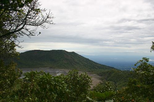
Turrialba, summit elevation 3325 m, stratovolcano .Turrialba volcano is located on the eastern end of the Cordillera Central. It is large and covered by vegetation except in the crater. There is a summit depression measuring 2 km E-W and 1.2 km N-S. Seismicity has appeared high under the volcano since 1996. 2012 Activity: On 12th January 2012 a new vent opened on the SE flank of Turrialba volcano. Ashfall was reported at Tres Rнos, 27 km SW of the volcano. On the 18th January a scientific team observed flames of combusting gas.2010 Eruption: On 5th January 2010 at 2:28 pm local time residents located on the southwest side of Turrialba Volcano, reported hearing a strong eruption Turrialba Volcanol. At Irazu Volcano National Park ash fell on parked vehicles. In addition, residents of Turrialba, and owners nearby farms on the slopes of Turrialba Volcano reported ashfall. Since mid-December 2009 until 4th January 2010, earthquakes were mainly long period. On 4th of January 2010 there was a significant increase in tremor volcanic, both in record time and in the amplitude of the signal, coinciding with the increase in the tremor there was a significant decrease in LP-type earthquakes. Twenty people were evacuated from the eruption. The eruption was caused by magma intrusion at depth, causing a heating of groundwater, and a sudden decompression through the fracture system.2008 Unrest: During September 2008 observations revealed damaged to vegetation at the volcano. On the southern flank of the West crater, plants were burned down to the soil. Trees in lower altitude areas were yellowed due to acid rain. Pastures and areas along canyons and depressions were also affected. Turrialba Volcano National Park was temporarily closed on 30th September because high levels of gas were blowing over parts of the park where visitors view the volcano.2007 Unrest: In August 2007 fractures and new funaroles opened at the volcano. Molten sulphur was observed at the volcano for the first time in 25 years.1950-60 Fumarolic activity.Large columns of vapour from Turrialba volcano were observed from the city of Cartago in the period 1950-1960.1920 Fumarolic activity: Large columns of vapour from Turrialba volcano were observed from the city of Cartago.1866 Eruption: An eruption of Turrialba volcano in 1866 covered most of Costa Rica in ash, and extended to Nicaragua. Eruptions: 2012, 2010, 1866, 1864-65, 1861?, 1855, 1853, 1847?, 1723 http://www.volcanolive.com/costarica.html |
The summit of Turrialba, the easternmost in the Cordillera Central, is seen here from its SW flank. The volcano rises to 3340 m about 25 km NW of the city of the same name and is exceeded in height in Costa Rica only by its neighbor Irazu volcano. Turrialba is excentric to the main volcanic chain and lies east of its axis. The summit area is designated as Turrialba National Park, and its northern flanks are part of the extensive Cordillera Volcanica Central forest reserve. Photo by Eliecer Duarte (OVSICORI-UNA).http://www.volcano.si.edu/world/volcano.cfm?vnum=1405-07= |
Turrialba is the SE-most and the 2nd-highest of Costa Rica''s Holocene volcanoes. The massive, vegetation-covered stratovolcano is seen here from the barren upper slopes of Irazu volcano to its SW. Three well-defined craters mark the upper end of a broad summit depression that is breached to the NE. Turrialba has been quiescent since a series of explosive eruptions in the 19th century that were sometimes accompanied by pyroclastic flows. Photo by William Melson, 1969 (Smithsonian Institution). http://www.volcano.si.edu/world/volcano.cfm?vnum=1405-07= |
Turrialba emits a translucent plume of volcanic gases in this natural-colour satellite image - http://en.wikipedia.org/wiki/Turrialba_Volcano |
Turrialba, the easternmost of Costa Rica''s Holocene volcanoes, is a large vegetated basaltic-to-dacitic stratovolcano located across a broad saddle NE of Irazъ volcano overlooking the city of Cartago. The massive 3340-m-high Turrialba is exceeded in height only by Irazu, covers an area of 500 sq km, and is one of Costa Rica''s most voluminous volcanoes. Three well-defined craters occur at the upper SW end of a broad 800 x 2200 m wide summit depression that is breached to the NE. Most activity at Turrialba originated from the summit vent complex, but two pyroclastic cones are located on the SW flank. Five major explosive eruptions have occurred at Turrialba during the past 3500 years. A series of explosive eruptions during the 19th century were sometimes accompanied by pyroclastic flows. Fumarolic activity continues at the central and SW summit cratersThe summit crater complex of Turrialba volcano is seen here from the north, with the Central Valley of Costa Rica in the background. Three well-defined craters can be seen at the upper SW end of a broad 800 x 2200 m wide summit depression that is breached to the NE. Turrialba has been quiescent since a series of explosive eruptions during the 19th century that were sometimes accompanied by pyroclastic flows. Hydrothermally altered ground can be seen at the central and SW summit craters (right), where fumarolic activity continues. Photo by Federico Chavarria Kopper, 1999.The rim of one of the three craters filling the large summit depression of Turrialba volcano is seen in the foreground with the wall of the breached summit depression in the background. This depression is 500-800 m wide in a NW-SE direction and 2200 m long in a NE-SW direction and is of possible slope-failure origin. Historical eruptions during the 18th and 19th centuries have originated from the three small craters within this depression. http://www.volcano.si.edu/world/volcano.cfm?vnum=1405-07= |
Volcano Turrialba It`s the most eastern tip volcano of the Cordillera Central (the second volcano in the country in respect of meters above sea level -3.339). It has been active since 6.300 BC. In colonial times it was nicknamed by Spaniards as Torre Alba "white tower", because of its eruptions gave the impression of a huge white tower. It has three craters. The catastrophic eruptions happened also in 1723, 1847, 1853, 1855 and 1861. Now scientists claim a new eruption might be expected.In March 2001 around the volcano there were some tremors and shakes felt by the surrounding towns. Many residents of the nearby area were afraid that maybe the new cycle of activity, but the scientists claimed the shakes had nothing to do with that. Turrialba, (3,340 m) the southeast-most of Costa Rica''s Holocene volcanoes, is a large vegetation-covered stratovolcano located to the northeast of Irazu volcano. Three well-defined craters occur at the upper end of a broad summit depression that is breached to the northeast. Turrialba has been quiescent since a series of explosive eruptions in the 19th century that were sometimes accompanied by pyroclastic flows. Fumarolic activity continues at the summit craters. http://vulcan.wr.usgs.gov/Volcanoes/CostaRica/description_costa_rica_volcanoes.html Turrialba Volcano is stratovolcano is 3,340 m. The summit has three craters, one of which has fumaroles and sulfur pits.Below the summit is a mountain range and cloud forest, with ferns, bromeliads, lichens and mosses. During the 19th century, it explosively erupted several times (1847?, 1853, 1855, 1861?, 1864�1865, 1866), producing pyroclastic flows. The last major eruption was in 1866, but in January 2001, the volcano reported increased activity, displaying strong fumaroles at the central craters. The volcanic activities have increased since 2005. In January 2010, the volcano emitted ash. Turrialba is adjacent to Irazu. It had at least five large explosive eruptions in last 3500 years. http://en.wikipedia.org/wiki/Turrialba_Volcano http://upload.wikimedia.org/wikipedia/commons/7/7f/Turrialba_Volcano_Sept_2005.jpg The summit is composed of three craters, shown in this image. The farthest is the oldest and the closest is the youngest. Continuous fumarolic emmissions rise from the crater and deposit condensate minerals around the vents. The trail in the middle distance leads to the central crater from which a few minor fumaroles are active. It is too treacherous to enter the active crater but a trail around the rim allows viewing from three sides |
http://upload.wikimedia.org/wikipedia/commons/7/7f/Turrialba_Volcano_Sept_2005.jpg |
The bottom of Turrialba''s central crater is inactive except for minor steam fumaroles. This allows close inspection of the fumarolic minerals. The descent into the crater is fairly easy, even with the thin air at the summit region (Foto by Liz Mockbee). http://www2.brevard.edu/reynoljh/costarica/2003/crvolcanoes.htm |
A broad depression breached widely to the NE (right) cuts the summit of Turrialba, the easternmost Holocene volcano in Costa Rica. The upper part of the depression is partially filled by a smaller edifice with a roughly 1.3-km-wide crater, within which three smaller craters aligned NE-SW have formed. The three young craters erupted during the 18th-19th centuries; the walls of the two SW-most craters display broad areas of light-colored, hydrothermally altered rocks. Fumarolic activity continues at these craters.Photo by Federico Chavarria Kopper, 1999. Three overlapping craters, each of which contains sub-craters, occur within the 2 x 4 km summit depression. A cloud bank at the upper right covers the breached NE end of the summit crater complex. http://www.volcano.si.edu/world/volcano.cfm?vnum=1405-07= |
The 50-m-deep central crater (seen here looking NE toward the breach in the large summit depression) and the SW crater were the site in 1866 of the last and largest historical eruption of Turrialba volcano. Phreatomagmatic eruptions in January and February produced ashfall in Costa Rica''s Central Valley for four days in January and three days in February. Ash fell as far as Puntarenas and El Realejo in Nicaragua. Pyroclastic surges traveled more than 4 km, and small lahars traveled down the Rнo Aquiares and presumably other valleys. Photo by Jose Enrique Valverde Sanabria, 1996 (courtesy of Eduardo Malavassi, OVSICORI-UNA). http://www.volcano.si.edu/world/volcano.cfm?vnum=1405-07= |
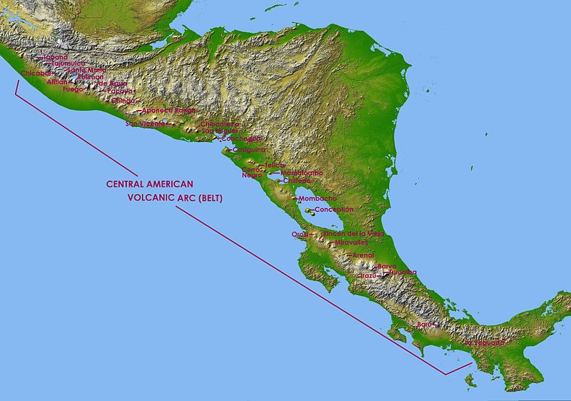

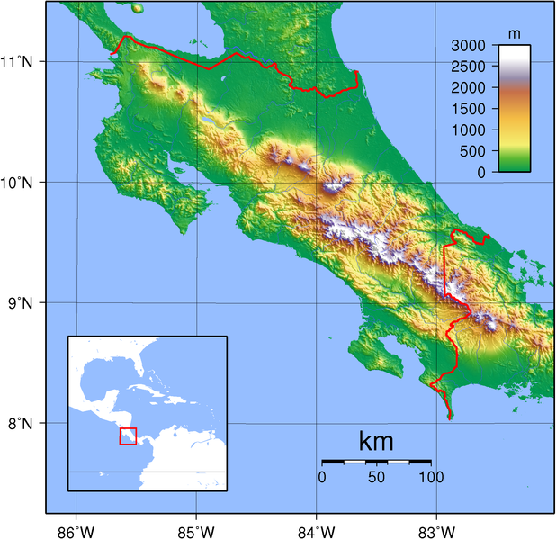
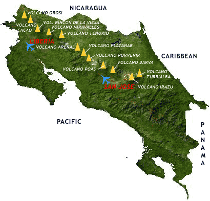
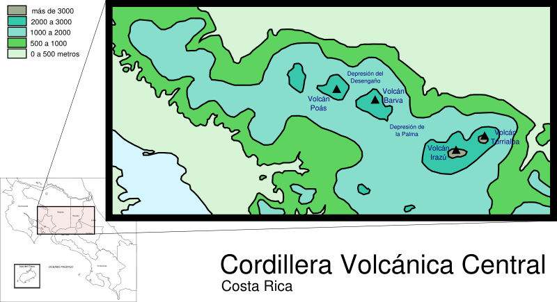


The Cordillera Central is a volcanic mountain range in central Costa Rica which continues the Continental Divide east of Cordillera de Tilaran. It extends 80 km from Tapezco Pass to the Turrialba Volcano and ending on the Pacuare River. It is separated from Cordillera de Tilaran by Balsa River and Platanar and Zarcero hills.
It contains four large volcanoes Poas (2,708 m), Barva (2,906 m), Irazu and Turrialba (3,340 m). The highest peak is Irazu at 3,432 m.
South of the range lie elevated plains of central tectonic depression of Costa Rican Central Valley.
Cordillera Central''s four main volcanoes are protected as national parks. Volcanic massif of the Poas Volcano is the central feature of Poas Volcano National Park, featuring permanent fumarolic activity. Barva Volcano features prominent hydrothermal activity (hot springs) and is a part of Braulio Carrillo National Park.
Irazu Volcano National Park contains Irazu Volcano, the highest volcano of Costa Rica. The significant elevation of the volcano makes it a strategic site for telecommunications, many national television and radio stations have their antennas at the summit.
Turrialba Volcano National Park centered around Turrialba Volcano features fumarolic activity and gas emissions http://en.wikipedia.org/wiki/Cordillera_Central,_Costa_Rica
Mountain ranges
The Tilaran Range is part of the Continental Divide east of Lake Arenal and the nearby active volcano Arenal, and running into the Cordillera Central range further east. At the edge of the range is the Monteverde cloud forest preserve.
The Central Range continues the Continental Divide east of Cordillera de Tilaran.
The Guanacaste Range is in northern Costa Rica near the border with Nicaragua. The range forms part of the southern region of the Continental Divide, the highest peak being the extinct stratovolcano Miravalles at 2,028 m. Peaks include: Miravalles Volcano (2,028 m), Orosi Volcano (1,659 m), Rincon de la Vieja Volcano (1,916 m)
Cordillera de Talamanca ( Talamanca Range )is included in the La Amistad International Park, which is shared between Costa Rica and Panama. The country''s highest peaks lie in this mountain range: the Cerro Chirripo and the Cerro Kamuk. Much of the region is covered by the forest.
The Cerros de Escazu borders the Central Valley to the south and is considered the northernmost portion of the Cordillera de Talamanca. http://en.wikipedia.org/wiki/Cordillera_de_Tilar%C3%A1n#Mountain_ranges
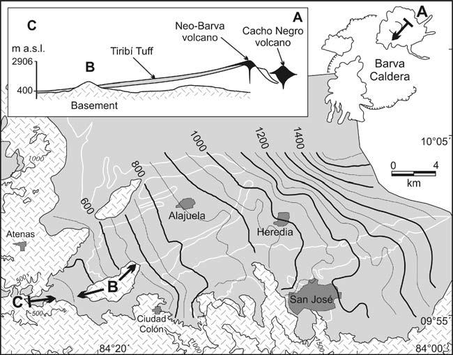
The Tiribi Tuff covered much of the Valle Central of Costa Rica, currently the most densely populated
area in the country (~2.4 million inhabitants). Underlying the tuff, there is a related well-sorted pumice deposit, the Tibas Pumice Layer. Based on macroscopic characteristics of the rocks, we distinguish two main facies in the Tiribi Tuff in correlation to the differences in welding, devitrification, grain size, and abundance of pumice and lithic fragments. The Valle Central facies consists of an ignimbritic plateau of non-welded to welded deposits within the Valle Central basin and the Orotina facies is a gray to light-bluish gray, densely to partially welded rock,with yellowish and black pumice fragments cropping out mainly at the Grande de Tarcoles River Gorge and Orotina plain. This high-aspect ratio ignimbrite covered an area of at least 820 km2 with a long runout of 80 km and a minimum volume outflow of 25 km3 (15 km3 DRE). Geochemically, the tuff shows a wide range of compositions from basaltic-andesites to rhyolites, but trachyandesites are predominant. Replicate new 40Ar/39Ar age determinations indicate that widespread exposures of this tuff represent a single ignimbrite that was erupted 322+/-2 ka. The inferred source is the Barva Caldera, as interpreted from isopach and isopleth maps, contours of the ignimbrite top and geochemical correlation (10 km in diameter). The Tiribi Tuff caldera-forming eruption is interpreted as having evolved from a plinian eruption, during which the widespread basal pumice fall was deposited,followed by fountaining pyroclastic flows. In the SW part of the Valle Central, the ignimbrite flowed into a narrow canyon, which might have acted as a pseudo-barrier, reflecting the flow back towards the source and thus thickening the deposits that were filling the Valle Central
depression. The variable welding patterns are interpreted to be a result of the lithostatic load and the influence of the content and size of lithic fragments. http://www.geo.mtu.edu/~raman/papers2/The%20Tiribi%20Tuff.pdf
http://www.volcanolive.com/costarica.html
http://www.volcano.si.edu/reports/bulletin/contents.cfm?issue=3604&display=complete Rincуn de la Vieja
http://www2.brevard.edu/reynoljh/costarica/2003/crvolcanoes.htm
http://www.turubari.com/htmlesp/conozca-costa-rica/costa-rica-volcanoes/
http://vulcan.wr.usgs.gov/Volcanoes/CostaRica/description_costa_rica_volcanoes.html costa rica north
http://www.volcano.si.edu/world/volcano.cfm?vnum=1405-06=
Panama
Geography of Costa Rica
The 322 ka Tiribi Tuff: stratigraphy, geochronology and mechanisms of deposition of the largest and most recent ignimbrite in the Valle Central, Costa Rica
Costa Rica
Panama