 | Cava Costa Rica/Panama |
National System of Conservation Areashttp://en.wikipedia.org/wiki/SINAC |
National System of Conservation Areas |
In Costa Rica there are many volcanic formations. Seven are considered to be active. Their activity is connected with fertile soils, which cover the majority of Costa Rica territory. The highest Costa Rica`s volcano is Irazu, the most active is Arenal and Poas has the second widest crater in the world. (diameter 1.5 km).Many of them are within the national parks. Costa Rica major volcanic peaks are stratovolcanos. The type of magma that fuels most Costa Rica volcanos is thick, viscous, and so filled with gases that the erupting magma often blasts violently into the air.The most serious eruption was that of Irazu volcanoe in 1963. It errupted clouds of smoke and ash that kept San Jose in a blanket of ash for two years. |
Volcan Orosнsituated in the Cordillera de Guanacaste. The area around the volcano is the Guanacaste National Park.At the base of the volcano is the Maritza Biological Station, which researches aquatic biology, founded in conjunction with Stroud Water Research Center, Avondale, Pennsylvania, USA |
http://www.mountain-forecast.com/peaks/Orosi-Volcano |
Orosi is one of a cluster of four eroded and vegetated cones in the Guanacaste Range at the NW corner of Costa Rica. Volcan Orosi itself has a conical shape as viewed from the north or west, but its flanks are heavily eroded. The complex includes Orosi, Orosilito, Volcбn Pedregal, and Cacao. The highest peak of the volcanic complex is 1659-m-high Volcбn Cacao, 5.5 km SE of Orosн. The summit of Cacao is cut by two large horseshoe-shaped calderas breached to the SW and east related to edifice collapse. The age of the latest activity of the Orosн complex is not known. Historical eruptions were reported from Orosi in 1844 and 1849, but even at the time of the first volcanological observations at the end of the 19th century, Orosн was overgrown with large trees, and the eruptions may actually have been from neighboring Rincуn de la Vieja volcano. The latest documented volcanic activity at Orosi produced mudflows (perhaps secondary) about 3500 years ago. The highest peak of the Orosн volcanic complex is Volcбn Cacao, which is seen in this view from the SW. The summit of Cacao, 5.5 km SE of Orosн, was breached to the SW as a result of edifice collapse. Orosi is one of a cluster of four eroded and vegetated cones in the Guanacaste Range at the NW corner of Costa Rica. Volcбn Orosн itself has a conical shape as viewed from the north or west, but its flanks are heavily eroded. The age of the latest activity of the Orosi complex is not known. The SW side of Volcan Cacao, located at the SE end of the Orosi volcanic massif, is cut by an arcuate depression created during a massive slope failure in which the summit of the volcano was removed. The vertical light-colored stripes on the upper edifice are rockslide scars. The latest eruptive activity at the Orosi complex consisted of post-collapse lava domes and flows from Cerro Cacao Photo by Cindy Stine, 1989 (U.S. Geological Survey). http://www.volcano.si.edu/world/volcano.cfm?vnum=1405-01=&volpage=photos |
Orosi, 10.980 N, 85.473 W , summit elevation 1659 m , Stratovolcanoes .The volcano is located in the Guanacaste Cordillera near the border with Nicaragua. It is 21 km south of Lake Nicaragua. It is composed of a cluster of 4 eroded cones, with a large and poorly preserved crater. All the cones are completely covered with vegetation. Eruptions of Orosi in 1844 and 1849 may have been due to Rincon de la Vieja volcano Unknown eruptions - http://www.volcanolive.com/costarica.html |
Volcano Cacao It`s placed in the Cordillera Guanacaste range. It has an open crater towards the south-west of which there is no recorded activity. On its steep slopes, numerous streams and rivers are born that flow into lake Nicaragua and the Nicoya Gulf as in the case of Tempisgue river. On its slope, at an elevation 1.050 mtrs. there is a Cacao Biological Station. It stands out also with a large number of petroglyphs.(1659 m.a.s.l.). It`s placed in the Cordillera Guanacaste range. It has an open crater towards the south-west of which there is no recorded activity. On its steep slopes, numerous streams and rivers are born that flow into lake Nicaragua and the Nicoya Gulf as in the case of Tempisgue river. On its slope, at an elevation 1.050 m.a.s.l. there is a Cacao Biological Station. |
Location and geological setting of the Cerro Chopo scoria cone (simplified after Denyer and Alvarado, 2007). The inset shows Costa Rica and its two volcanic ranges the Cordillera Central (CC) and the Cordillera de Guanacaste (CG). The last one is also shown in the shaded relief as the darker region. The middle gray area corresponds to the ignimbritic fan deposits (1.6¢0.6 Ma) from two recent calderas, and the brightest gray is the Bagaces ignimbritic plateau (2¢4 Ma). Cerro Corobicн scoria cone is also shown to the northwest of Cerro Chopo. Cerro Chopo is unique by the rhythmic reverse grading of its stratigraphic layers. Cerro Chopo is a pyroclastic cone because of the predominance of high density, poorly vesicular juvenile fragments. Compilation of the reported cases of spherical bombs, a type of pyroclastic fragment only found in a few places on Earth Cerro Chopo is a partially dissected, asymmetric, isolated Pleistocene pyroclastic cone, located in front of the Cordillera de Guanacaste, in northern Costa Rica. The cone consists of ~ 0.09 km3 of basaltic tephra, as well as ~ 0.14 km3 of lateral lava flows. Tephras are tholeiitic, high-alumina, olivine basalts, and represent minor degrees ( 5%) of crystal fractionation. Major and trace element compositions are consistent with minor fractionation from a mixture of E-MORB and OIB magmas. The cone walls consist of alternating coarser- and finer grained well-sorted beds, containing continuous spectra from breadcrust to smooth surface cannonball bombs, but also less frequent cylindric fragments and broken clasts. Cerro Chopo is unique compared to other typical scoria cones because it contains ubiquitous reversely-graded layers, scarcity of scorias, and instead a wide range of dense (1.54¢2.49 g/cm3) poorly vesicular (5¢40 vol.%) juvenile clast morphologies, including abundant cannonball juvenile bombs and lapilli. These are bombs with concentric layers surrounding vesiculated, dense and lapillistone cores and are interpreted to have repeatedly recycled through the vent. The cannonball bombs and lapilli have been described in a few scoria cones but are much less abundant than in Chopo. The reverse graded sequences are interpreted to have resulted from decreasing explosivity at the vent, in addition to local failure of tephra on slopes as the consequence of grain flows. Elsewhere on the Earth, most of the poorly-vesiculated spherical bombs, particularly cannonball, accretionary, composite, and core bombs, and its equivalent lapilli size (pelletal, spinning droplets and ellipsoidal lapilli), are all related to mafic to ultramafic, low-viscosity magmas. http://www.sciencedirect.com/science/article/pii/S0377027310003549 |
Geological map of the Cerro Chopo cone modified after and . The lava flows are distributed to the northeast. The red quadrangle represents the area studied in detail where the quarries are located. The star shows the position of the vent suggested by Mora (1977) and the red dashed lines are major faults http://www.sciencedirect.com/science/article/pii/S0377027310003549 |
Sketch of the quarry at Cerro Chopo showing by arrows the stratigraphical profiles used for correlation, as well as the structural elements like bedding and faults. The red discontinuous lines point to the axis of the antiform and synform built by the bedding.http://www.sciencedirect.com/science/article/pii/S0377027310003549 |
The Cerro Chopo basaltic cone (Costa Rica): An unusual completely eversed graded pyroclastic cone with abundant low vesiculated cannonball juvenile fragments. Major types of juvenile fragments of the Cerro Chopo cone: a. breadcrust bombs, b. cylindric bombs and c. cannonball bombs. The cannonball can be ellipsoidal or spherical in shape, some with incipient to well breadcrusted structure, and their internal structure shows frequently a rind. No pictures from broken clasts are shown.http://www.sciencedirect.com/science/article/pii/S0377027310003549 |
Density variations of the main clast types. Note that cannonball bombs with breadcrusted structure exhibit a density higher than 2 g/cm3, same as typical cannonball fragments.http://www.sciencedirect.com/science/article/pii/S0377027310003549 |
Diagram B/A versus C/B, where A is the longest axis, B the intermediate and C the smallest, of the different types of volcanic bombs and their relationship with sphericity of Krumbein (1941) indicated by the curved lines (modified after and ). No pictures from broken clasts are shownhttp://www.sciencedirect.com/science/article/pii/S0377027310003549 |
Microphotographs of the Cerro Chopo rocks: a. poorly vesicular (30%) bomb with olivine and pyroxene phenocrysts; b. detail of the matrix, rich in plagioclase, pyroxene and magnetite microliths; and c. partially oxidized olivine phenocryst http://www.sciencedirect.com/science/article/pii/S0377027310003549 |
Stratigraphic profiles of the eastern and western sequences. Both profiles are located at opposite sides of the antiform, the eastern sequence is coarser grained than the western sequence, represented by a higher bomb population which also suggests nearer vent facies. Gray parts represent studied parts of the stratigraphyhttp://www.sciencedirect.com/science/article/pii/S0377027310003549 |
Various photographs showing the deposits and other features at Cerro Chopo: a. basal lithic-rich phreatomagmatic beds; b. large bomb slab at the eastern sequence near the suggested vent; c. agglomerate at the vent-near facies; d. finer ash beds, abundant mostly at the upper portions of the Western sequence; e. ubiquitous typical reverse grading present at Chopo, and f. coarse-grained lens evidencing down slope rolling of large clasts. http://www.sciencedirect.com/science/article/pii/S0377027310003549 |
The Cordillera de Guanacaste are a volcanic mountain range. The mountain range stretches 110 km from northwest to the southeast and contains mostly complex stratovolcanoes. The range as forms part of the southern region of the Continental Divide, with the highest peak is the stratovolcano Miravalles at 2,028 m. The range contains areas of ecological significance, as the Miravalles Forest Reserve, hills and canyons that can be seen from the lowlands of Guanacaste, areas rich with epiphytes, ferns and palms; and areas of geothermal activity. http://en.wikipedia.org/wiki/Cordillera_de_Guanacaste Cordillera de Guanacaste de Costa Rica -http://www.skyscrapercity.com/showthread.php?p=50863787 |
The spectacular Miravalles Volcano is located in the Guanacaste mountain range 21miles outside of Liberia in an east-southeast direction; This awe inspiring volcano stands 600m above sea level boasting a total height of 2028m. 10,850 hectares of land surrounding the volcano have been acknowledged as a protected area and named the Miravalles Forest Reserve since March 16, 1976. This reserve protects rivers and tributaries that surge across the Gulf of Nicoya and into the fields of Nicaragua. The complex Miravalles stratovolcano also shelters a beautiful cloud forest and primary rainforest that overflows with coconut palm trees, epiphites and ferns; while also being home to wild felines, coyotes, white tail deer, pacas, white faced capuchin monkeys and peccaries just to name a few of the wildlife species that run rampant here.Miravalles Volcano boasts young lava flows that pour over the west and southwest slopes. At the peak of Miravalles you will discover six eruption points, though the main crater is dormant. This splendid volcano is adorned with hot mud pits (some mudpots have been measured to be as deep as 2m featuring diameters as wide as 6-7m, bubbling water pools, waterfalls, thermal springs, fumaroles and crystallized sulfur. The geographic position of Miravalles Volcano interrupts cloud flows that come in from the Caribbean coast, which produces frequent showers, heavy cloud covers, tremendously strong winds as well as cold rains. Annual rainfall can reach up to 140 inches. Ordinary temperatures in the area of Miravalles range from 75F to 90F. At the top of the volcano temperatures usually register between 42F and 48F, but have been known to drop to as low as 32F. Even though Miravalles volcano is constantly monitored, the last known ōeruptionö was a small geyser-like steam explosion that took place in 1946. Some small seismic activity does take place regularly inside and under the main crater.Miravalles Volcano is known for it many different points of interest; the most famous is probably the Las Hornillas tour center located in the southwest area; a family owned business that has created a living museum spa that displays hydrothermal movement along with other terrific features of the volcano. Costa RicaÆs oldest Pre-Hispanic archeological findings were discovered at the Miravalles Volcano. An ambitious development called Proyecto Geotermico Miravalles is a huge underground reservoir that is heated by geothermic activity which it tries to harness; this reservoir is an energy plant that actually generates electricity for the zone.Miravalles is situated along the volcanic front of Central America, just southeast of a postulated boundary between eastern Nicaragua and Costa Rican segments of the Cocos-Caribbean subduction zone (Stoiber and Carr, 1973). Miravalles Caldera formed approximately 500,000 +/- 150 KA (Tournon, 1984), after eruption of voluminous silicic ash flows. An andesitic stratovolcano of the same name grew within the caldera (Healy, 1969). At least five cones are recognizable in the summit area, distributed along a northeast-trending line (probable fault). The modern intracaldera cone may be the second of two; a previous postcaldera cone was destroyed (R. Fournier, oral commun., 1987). Melson and others (1986) note a preliminary age of 8,000 (?) years B.P. for a major plinian eruption from Miravalles, and an age of 7,000 (?) years B.P. for a large debris avalanche from Miravalles. A geothermal field is situated between the caldera scarp and Miravalles stratovolcano. No significant eruption has occurred at Miravalles in historical time. However, on 14 September 1946, a small steam eruption occurred high on the south flank of the volcano, near the summit crater. Weak earthquakes were felt at the time. An explosion crater 20 meters in diameter formed, and steam, mud, and ash were thrown 100 meters high (Hantke, 1951, citing a letter from Sigismund von Preussen of the town of La Barranca). The hydrothermal field is a hot-water-dominated system, with a vapor-dominated cap (few tens of meters thick) in some parts of the geothermal field. Changes in the vapor-dominated cap can give rise to surface hydrologic changes and small blowouts. Fumarolic activity has reportedly decreased in recent years (as of late 1987) (R. Fournier, oral commun., 1987). http://vulcan.wr.usgs.gov/Volcanoes/CostaRica/description_costa_rica_volcanoes.html |
TENORIO - MIRAVALLES - RINCoN DE LA VIEJA |
Rincon de la Vieja It appeared millions years ago. It has 9 craters (Rincon - 1.806 m., Von Seebach - 1.895 m., Santa Maria - 1.916 m.) and is considered as the third most active volcano in Costa Rica. Santa Maria crater is considered to be as the separate volcano. It`s main crater has elipse shape, 500 meters of width and 100 meters of depth. On its bottom there is a hole with bubbling 250 Celsius lava. To the east of crater there is a lake, waterfalls and bubbling mud holes. In the terrain called Las Hornillas, the fumaroles hiss like kettles spitting up odiferous steam and gases. The last vital eruptions took place in 1966-1970. They were accompanied by clouds of ashes, earthquakes and tremors. The lighter eruptions took part in 1984, 1891 and 1996.Rincon de la Vieja, the largest volcano in northwest Costa Rica, is a remote volcanic complex in the Guanacaste Range consisting of an elongated, arcuate NNW-SSE-trending ridge. At least nine eruptive vents are located within an older 15-kilometer-wide caldera remnant, with activity migrating to the southeast, where the youngest-looking craters are located. The twin cone of 1,916-meter-high Santa Maria volcano, the highest peak of the Rincon complex, is located at the eastern end of a smaller, 5-kiloeter-wide caldera and has a 500-meter-wide crater. A Plinian eruption producing the 0.25 cubic kilometers Rio Blanca tephra about 3,500 years ago was the last major magmatic eruption from the volcano. All subsequent eruptions, including numerous historical eruptions possibly dating back to the 16th century, have been from the Active Crater, which contains a 500-meter-wide crater lake. Rincon de la Vieja, is situated along the volcanic front of Central America, at or just southeast of a postulated boundary between eastern Nicaragua and Costa Rican segments of teh Cocos-Caribbean subduction zone (Stoiber and Carr, 1983). Rincon de la Vieja, the largest volcano in northern Costa Rica, consists of six volcanic centers that form an elongate ridge, built on a shield of ignimbrites. Healy (1969) outlined a large, 15-20 kilometer diameter caldera within which the present ridge-shaped volcano has grown. Carr and others (1986) concurred with this interpretation and outlined another nested, 5-kilometer-diameter caldera on the Rincon de la Vieja edifice. Most historical eruptions of Rincуn de la Vieja have been vulcanian, Strombolian, or phreatic explosions from the central crater of the complex. http://vulcan.wr.usgs.gov/Volcanoes/CostaRica/description_costa_rica_volcanoes.html |
Rincon de la Vieja is an active andesitic complex volcano in north-western Costa Rica, 1,916 m above sea level, and its summit is the highest point in Rincon de la Vieja Volcano National Park. It erupted most recently in September 2011. The volcano has a large number of fumaroles and hot springs on its slopes. It is formed by felsic lava.Rincon de la Vieja is one of six active Costa Rican volcanoes: the others are Poas, Irazu, Miravalles, Arenal, and Turrialba.Rincon de la Vieja is a ridge-shaped massif, with several volcanic vents lying along a northwest-southeast axis. Several craters and peaks exist, with Santa Marнa peak being the highest at 1916m above sea level. Von Seebach peak, 1895m above sea level, has been the site of most historical eruptions.Little is known about Rincon de la Vieja''s early eruptive history. It lies within a larger caldera, which indicates that a very large eruption probably occurred thousands of years ago. Analysis of nearby pyroclastic flow deposits shows that they were erupted in a moderately large eruption about 3500 years ago, and the first recorded eruption of the volcano took place in 1765.Since then, many minor eruptions have occurred, the most recent in September 2011. They have mostly occurred at a crater near Von Seebach peak, and have been characterised by strombolian and vulcanian activity in which eruptions are confined to the crater, and ash is erupted to moderate heights. The active crater is currently filled with a hot, acidic crater lake. Large number of hot pools and areas of bubbling mud are found in two areas on the slopes of the volcano, indicating substantial reserves of geothermal energy. Investigations have been carried out into the feasibility of tapping these reserves, and the volcano is estimated to have a generating potential of 140 megawatts. However, as the area is protected within a national park, drilling has so far been limited to test wells. Further drilling will require approval after studies of the likely environmental impact.. http://en.wikipedia.org/wiki/Rinc%C3%B3n_de_la_Vieja_Volcano |
The elongated profile of the Rincon de la Vieja massif is less prominent in this view from the west across the coastal plain. The volcanic massif is the largest in NW Costa Rica. It has an estimated volume of 130 cu km and is sometimes referred to as the "Colossus of Guanacaste." A rhyolitic ignimbrite, the Liberia Tuff, originated from Rincуn de la Vieja during the early Pleistocene. It covered an area of 3500-4000 sq km, blanketing wide areas of the Pacific coastal plain south and west of the volcano.Photo by Guillermo Alvarado (Instituto Costarricense de Electricidad).http://www.volcano.si.edu/world/volcano.cfm?vnum=1405-02=&volpage=photos |
Cerro San Roque (left), Cerro Gongora (center), and Cerro Canas Dulces (right), seen here from the west along the Pan-American highway, are rhyodacitic lava domes just outside the Guachipelнn caldera. The domes were formed prior to eruption of the Liberia Tuff and formation of the caldera about 1.6 million years ago.Photo by Lee Siebert, 1998 (Smithsonian Institution).http://www.volcano.si.edu/world/volcano.cfm?vnum=1405-02=&volpage=photos |
Barren slopes surround the Active Crater of the Rincon de la Vieja volcanic massif in this aerial view from the NE. Los Jilgueros lake is in the middle and the large forested inactive crater of Rincуn de la Vieja behind it and to the left. Santa Maria volcano is in the far background. An aerial view from the north looks down on the acidic lake of the Active Crater. Layered pyroclastic deposits are exposed in its SW crater wall. The crater rim of forested Rincуn de la Vieja cone is at the upper left, with the non-volcanic Jilgueros lake (also known as Laguna Fria) at the top centerThe barren slopes of Von Seebach cone at the upper right are a result not of its frequent eruptions, but of tephra and acidic gases blown downwind from the lake-filled Active Crater (left). Steady trade winds from the NNE distribute acidic vapors rising from Active Crater to the SW, creating the "Dead Zone" that extends down the SW flanks visible at the extreme upper right. Part of the complex summit region of Rincуn de la Vieja, the largest volcano in NW Costa Rica, is seen here from the north. Steam rises from the lake-filled Crбter Activo at the left, ENE of the shallow 1895-m-high Von Seebach crater (upper right). Laguna Fria (upper left) is not a crater lake, but a freshwater lake that formed between overlapping cones of the summit complex, which extends east and west beyond the area of this photo. Frequent historical eruptions from Crбter Activo have left surrounding terrain unvegetated and scarred by erosional gullies. Photo by Federico Chavarria Kopper, 1999. http://www.volcano.si.edu/world/volcano.cfm?vnum=1405-02=&volpage=photos |
Photo of the active crater lake of Rincon de la Vieja on 29 April 2010 showing yellow sulfur deposits and fumarolic activity along the SW wall of the crater. This kind of activity was typical throughout the reporting interval (last half of 2008 through January 2011). Photo by E. Fernandez, OVSICORI-UNA. Rincon de la Vieja, the largest volcano in NW Costa Rica, is a remote volcanic complex in the Guanacaste Range. The volcano consists of an elongated, arcuate NW-trending ridge that was constructed within the 15 km wide, early Pleistocene Guachipelin caldera, whose rim is exposed on the S side. Rinc¾n de la Vieja, sometimes known as the "Colossus of Guanacaste," has an estimated volume of 130 cu km and contains at least 9 major eruptive centers. Activity has migrated to the SE, where the youngest-looking craters are located. The twin cone of 1,916-m-high Santa MarĒa volcano, the highest peak of the Rincon complex, is located at the E end of a smaller, 5-km-wide caldera and has a 500-m-wide crater. A Plinian eruption producing the 0.25 cu km Rio Blanca tephra ~3,500 years ago was the last major magmatic eruption from the volcano. All subsequent eruptions, including numerous historical eruptions possibly dating back to the 16th century, have been from the prominent crater containing a 500-m-wide acid lake (known as the Active Crater) located ENE of Von Seebach crater. Low-frequency earthquakes and tremor were reported at Rincon de la Vieja during the first half of 2008 (BGVN 33:07). Since then, Observatorio Vulcanologico Sismologica de Costa Rica-Universidad Nacional (OVSICORI-UNA) had issued intermittent reports of activity through January 2011. Those reports are summarized in the following sections, with much of the discussion centered around fumaroles and behavior of the geothermally warmed lake in the active crater. Occasional, typically small phreatic eruptions had occurred here in past years, for example in the 1990s (eg., BGVN 21:02, 21:03, 22:01, and 23:03) but were absent in the current reporting interval (last half of 2008 through January 2011).August 2008. OVSICORI-UNA reported that the level of the lake was at a high level, with a bluish color, generated convection cells with evaporation, and had sulfur particles visible on it''s surface. Sulfur deposition and fumarolic activity continued along the SW wall.March 2009. In mid-March 2009, scientists visited the S and SW flank, collected samples, and noted some temperatures of 75-78░C. Because the visit occurred during the dry season, most areas encountered were dry. The scientists examined an area of acidification to the W of Von Seebach crater, ~3 km SW of the active crater. Strong winds common in that direction sometimes carried volcanic gases. Consequently, most of this narrow expanse only contained patches of grassland and shrubs that barely covered the rocky surface.October 2009. OVSICORI-UNA reported that seismographic station RIN3, located ~5 km SW of the main crater, registered volcano-tectonic events and tremor lasting for minutes.Weak ongoing fumarolic activity during 2010 through January 2011. OVSICORI-UNA reported that the level of the crater lake remained high during 2010, with constant evaporation. Geochemical, seismic, and deformation data did not show significant changes in physico-chemical parameters during 2010. The changing color of the lake, from blue to gray, was attributed to intense rains and fumarolic activity in the crater.Later reporting. Reports during 2010 through at least January 2011 described fumarolic activity along the S and SW walls of the crater, with sulfur deposition and moderate gas discharge. The lake remained a gray color, with sulfur particles in suspension. Figure 32 shows a photo taken in April of the crater looking at the SW wall with fumarolic activity along with sulfur deposition. In April 2010, OVSICORI-UNA reported that the temperature of the lake was 49░C. A fumarole sometimes seen active along the N flank had stopped discharging gas http://www.volcano.si.edu/reports/bulletin/contents.cfm?issue=3604&display=complete |
The rim of Active Crater is highest on the SW side and drops rapidly on the NW side. The 700-m-wide crater contains an acidic lake that is periodically partially ejected by explosive eruptions and therefore varies in depth. Trade winds from the ENE distribute acid fumarolic plumes from the Active Crater to the SW, destroying vegetation. Water geochemistry studies indicate that the crater lake water is leaking through the edifice into the north flank drainages. The walls of Crбter Activo (Active Crater) expose thick sequences of oxidized and hydrothermally altered pyroclastic deposits and light-colored lava flows. Many sublacustral eruptions from Active Crater have originated from vents beneath the acidic crater lake seen at the lower right.Photo by Guillermo Alvarado (Instituto Costarricense de Electricidad). http://www.volcano.si.edu/world/volcano.cfm?vnum=1405-02=&volpage=photos |
The turquoise-colored crater lake of the Crбter Activo of Rincуn de la Vieja is seen here on April 2, 1998 from its eastern rim during a quiet period of the 1998 eruption. The eruption began with phreatic explosions during February 15-18 that produced steam plumes up to 2 km above the crater lake and scorched vegetation on the NE side of the crater. On February 16 a mudflow traveled up to 12 km down the Penjamo and Azul rivers. Twenty explosions were recognized from seismic records, and additional explosions were recorded in May, June, and September. Photo by Josй Enrique Valverde Sanбbria, 1998 (courtesy of Eduardo Malavassi, OVSICORI-UNA).http://www.volcano.si.edu/world/volcano.cfm?vnum=1405-02=&volpage=photos |
This aerial photo from the north overlooks the summit cone complex of the Rincon de la Vieja volcanic massif, the largest volcano in NW Costa Rica. A steam plume rises from the acidic turquoise-colored lake of the Active Crater, and erosional gullies cut its tephra-mantled slopes. Dark-colored Laguna Fria beyond the Active Crater is a non-volcanic lake formed between the forested Rincуn de la Vieja crater (middle left margin) and the ridge extending to Santa Mari cone at the upper left margin of the photo. Photo by Federico Chavarria Kopper, 1996.Laguna de Fria is seen here from the west, along a ridge crest near Active Crater. Laguna de Fria (also known as Laguna los Jilgueros) does not lie within a volcanic crater, but was formed when meteoric waters accumulated in a depression between overlapping cones of the Rincon de la Vieja complex. The peak at the upper right is Rincon de la Vieja cone. It is one of many peaks forming the elongated summit ridge of the Rincon de la Vieja volcanic complex, and its forested summit contains a roughly 700-m-wide crater. http://www.volcano.si.edu/world/volcano.cfm?vnum=1405-02=&volpage=photos |
A steam plume rises from Active Crater, seen here from the south. An acid crater lake fills the innermost of two nested craters of the historically active pyroclastic cone. Frequent historical eruptions and the production of acid rain have kept the flanks of the cone unvegetated. Remobilization of fresh ashfall deposits has led to mudflows down the Quebrada Azufrosa at the upper right.Photo by Federico Chavarria Kopper, 1999.http://www.volcano.si.edu/world/volcano.cfm?vnum=1405-02=&volpage=photos |
An ash-laden eruption column rises above Rincуn de la Vieja volcano on June 4, 1922. About two months earlier (on April 11) evidence of a recent large eruption had been observed. After the explosive eruption of June 4, no further eruptive activity was recorded until 1966, when eruptions began occurring more frequently.10.83 N, 85.32 W ,summit elevation 1916 m ,complex volcano . Rincon de la Vieja is an active andesitic stratovolcano in north-western Costa Rica, about 25 km from Liberia. It is a complex volcano which has built from several eruptive centres that have merged into a single mountain.2012 Eruption:A phreatic eruption occurred at Rincуn de la Vieja volcano on 14th April 2012. The eruption was located at a hot acidic lake.2011 Eruptions: Phreatic eruptions occurred at Rincуn de la Vieja volcano on 19th August, 16th September and 22nd September 2011. Some fish were killed in Penjamo River. Eruptions: 2012, 2011, 1998, 1995, 1992, 1992?, 1991, 1991, 1987, 1986, 1985-86, 1984, 1983, 1970, 1969, 1969, 1966-67, 1922, 1917?, 1912, 1902?, 1861-63, 1860, 1853-54, 1851?, 1849, 1844, 1765, 1529? http://www.volcanolive.com/rincon.html Photo by Jose Tristan, 1922 (courtesy of Jorge Barquero). |
Deposits of the Liberia Tuff are exposed in steep-walled gullies SW of the volcano. The rhyolitic ignimbrite was erupted about 1.6 million years ago and blanketed an area of 3500-4000 sq km. The Liberia Tuff differs from other ignimbrite deposits in NW Costa Rica in containing a large amount of biotite phenocrysts. Eruption of the 25 cu km ignimbrite was associated with formation of the 15-km-wide Guachipelнn caldera, inside which the modern Rincуn de la Vieja massif was constructed.Photo by Lee Siebert, 1998 (Smithsonian Institution). http://www.volcano.si.edu/world/volcano.cfm?vnum=1405-02=&volpage=photos |
Fumarolic plumes issue from vents at the margin of a pool at the Aguas Termales thermal area on the southern base of Rincуn de la Vieja volcano. A popular recreational trail in Rincуn de la Vieja National Park makes a circuit through the mudpots and fumaroles of the geothermal area.Photo by Paul Kimberly, 1988 (Smithsonian Institution). http://www.volcano.si.edu/world/volcano.cfm?vnum=1405-02=&volpage=photos |
Steam rises from active bubbling mudpots at the Aguas Termales thermal area, one of several at the southern base of the Rincуn de la Vieja massif in the national park of the same name.Photo by Paul Kimberly, 1998 (Smithsonian Institution). http://www.volcano.si.edu/world/volcano.cfm?vnum=1405-02=&volpage=photos |
The Aguas Termales geothermal field at the southern base of Rincon de la Vieja volcano contains active mudpots. Several geothermal areas occur along a NW-trending lineation at the base of the volcano. Soil mercury studies delineate a fault parallel to the volcanic front that connects the geothermal sites.http://www.volcano.si.edu/world/volcano.cfm?vnum=1405-02=&volpage=photos |
Rincon de la Vieja National Park is host to more than 300 species of birds, including quetzals, toucanets, and eagles. Mammals include howler, spider, and white-faced monkeys, kinkajous, sloths, tapirs, tayras, cougars, and even jaguars |
Simplified geologic map of NW Costa Rica. The Guanacaste volcanic chain consists of five Quaternary volcanoes, including (from SE to NW) Tenorio, Miravalles, Rincón de la Vieja, Cacao, and Orosı́. Deposits from these Quaternary volcanoes overlie a broad ignimbrite plateau, formed by multiple Plio-Pleistocene caldera eruptions. Two partial caldera structures have been recognized: the Guayabo caldera at Miravalles, and the Guachipelı́n caldera at Rincon de la Vieja. |
Profile of Rincon de la Vieja viewed toward north, showing the location of the Active Crater and Von Seebach and Santa Marı́a cones. The barren slopes on the left side of the volcano represent the ōdead zoneö where volcanically derived acid rain has precluded significant vegetation. A broad ignimbrite plateau and associated dacite lava dome, related to silicic caldera eruptions in the Pleistocene, are shown in the foreground. The profile of Rincon de la Vieja in this photo is approximately 18 km, trending from NW to SE. http://www.sciencedirect.com/science/article/pii/S037702739900181X |
Aerial photomosaic of western summit craters at Rincon de la Vieja. Mixing of acidic vapors from the Active Crater with ENE trade winds produces acid rain along the volcano''s western summit and southwestern flank. The absence of vegetation and deep erosion resulting from this ongoing process have exposed deep stratigraphic profiles within the area referred to as the ōdead zoneö.http://www.sciencedirect.com/science/article/pii/S037702739900181X |
View of the Active Crater toward north. North crater wall stratigraphy consists of a lower sequence of thin lavas (1¢3 m thick) intercalated with highly altered tephra deposits. On the west side of the crater, a younger sequence of phreato-magmatic tephra deposits (>30 m thick) caps the lower sequence http://www.sciencedirect.com/science/article/pii/S037702739900181X |
Location of water sample sites. Identified on this map are acid chloride-sulfate (ACS) waters of the Active Crater and north-flank streams, acid sulfate (AS) waters of hot springs and boiling pools found along the south flank (Borinquen, Las Hornillas, and Las Pailas), and neutral chloride (NC) waters found at Salitral (just south of Cerro Fortuna).Leakage of Active Crater lake brine through the north flank at Rincуn de la Vieja volcano, northwest Costa Rica, and implications for crater collapseThe Active Crater at Rincon de la Vieja volcano, Costa Rica, reaches an elevation of 1750 m and contains a warm, hyper-acidic crater lake that probably formed soon after the eruption of the Rio Blanco tephra deposit approximately 3500 years before present. The Active Crater is buttressed by volcanic ridges and older craters on all sides except the north, which dips steeply toward the Caribbean coastal plains. Acidic, above-ambient-temperature streams are found along the Active Crater''s north flank at elevations between 800 and 1000 m. A geochemical survey of thermal and non-thermal waters at Rincуn de la Vieja was done in 1989 to determine whether hyper-acidic fluids are leaking from the Active Crater through the north flank, affecting the composition of north-flank streams.Results of the water-chemistry survey reveal that three distinct thermal waters are found on the flanks of Rincуn de la Vieja volcano: acid chloride¢sulfate (ACS), acid sulfate (AS), and neutral chloride (NC) waters. The most extreme ACS water was collected from the crater lake that fills the Active Crater. Chemical analyses of the lake water reveal a hyper-acidic (pH=0) chloride¢sulfate brine with elevated concentrations of calcium, magnesium, aluminum, iron, manganese, copper, zinc, fluorine, and boron. The composition of the brine reflects the combined effects of magmatic degassing from a shallow magma body beneath the Active Crater, dissolution of andesitic volcanic rock, and evaporative concentration of dissolved constituents at above-ambient temperatures. Similar cation and anion enrichments are found in the above-ambient-temperature streams draining the north flank of the Active Crater. The pH of north-flank thermal waters range from 3.6 to 4.1 and chloride:sulfate ratios (1.2¢1.4) that are a factor of two greater than that of the lake brine (0.60). The waters have an ACS composition that is quite different from the AS and NC thermal waters that occur along the southern flank of Rincon de la Vieja. The distribution of thermal water types at Rincуn de la Vieja strongly indicates that formation of the north-flank ACS waters is not due to mixing of shallow, steam-heated AS water with deep-seated NC water. More likely, hyper-acidic brines formed in the Active Crater area are migrating through permeable zones in the volcanic strata that make up the Active Crater''s north flank. Dissolution and shallow subsurface alteration of north-flank volcanoclastic material by interaction with acidic lake brine, particularly in the more permeable tephra units, could weaken the already oversteepened north flank of the Active Crater. Sector collapse of the Active Crater, with or without a volcanic eruption, represents a potential threat to human lives, property, and ecosystems at Rincon de la Vieja volcano. Keywords: magmatic degassing http://www.sciencedirect.com/science/article/pii/S037702739900181X |
Conceptual hydrologic model for Rincon de la Vieja. Acid chloride-sulfate (ACS) waters are formed by mixing of high-temperature magmatic volatiles with infiltrating meteoric water, which absorbs HCl and SO2. Disproportionation of SO2 leads to the formation of sulfuric acid and H2S, which, in combination with dissociation of HCl, leads to formation of a low-pH ACS water. Dissolution of andesitic volcanic rock combined with further evaporative concentration in the crater lake produces a hyper-acidic, metal-rich, chloride¢sulfate brine that then seeps away from the Active Crater, discharging on the north flank as partially neutralized ACS waters. ACS fluids migrating toward the south are progressively neutralized and reduced; separation of steam, H2S, and SO2 along the major NW-trending fault near the base of the volcano forms acid sulfate (AS) hot springs and boiling pools at Borinquen. Boiling and continued hydrolysis reactions produce neutral chloride waters that continue to migrate laterally away from the volcano, eventually discharging near Salitral about 14 km west-southwest of the Active Crater http://www.sciencedirect.com/science/article/pii/S037702739900181X |
Miravalles Volcano, 2028m, Range Cordillera de Guanacaste, stratovolcano, age of rocks 1.5 MY. Miravalles volcano 10.74 N, 85.15 W is located in the Cordillera del Guanacaste. It is a deeply eroded volcano without a crater. The volcano is the site of a developed geothermal area.1997 Earthquake Swarm: Between 5-27 October 1997 an earthquake swarm occurred under the south flank of Miravalles volcano. The swarm consisted of 620 earthquakes.1991-94 Seismicity: Between April 1991 and July 1994 there were 219 earthquakes measured at Miravalles caldera. The earthquakes occurred within a radius of 15 km of the geothermal field. http://www.volcanolive.com/costarica.html Volcano Miravalles It`s the highest in Cordillera Guanacaste. It contains 5 cones along a North-East trending line. The only reported historical eruptive activity was a small steam explosion in 1946. On its slopes a few mud bubbling pots and thermal springs. On cloudless days, from the top it`s possible to see Nicaragua Lake. |
The Miravalles Volcano is an andesitic stratovolcano, last eruption 1946. The caldera was formed during several major explosive eruptions that produced voluminous dacitic-rhyolitic pyroclastic flows between about 1.5 and 0.6 MA. The only reported historical eruptive activity was a small steam explosion on the SW flank in 1946. High heat flow remains, and Miravalles is the site of the largest developed geothermal field in Costa Rica Miravalles is a 2028-m-high andesitic stratovolcano that is one of five post-caldera cones along a NE-trending line within the broad 15 x 20 km Guayabo (Miravalles) caldera. The caldera was formed during several major explosive eruptions that produced voluminous dacitic-rhyolitic pyroclastic flows between about 1.5 and 0.6 million years ago. Growth of post-caldera volcanoes in the eastern part of the caldera that overtopped much of the eastern and southern caldera rims was interrupted by edifice collapse that produced a major debris avalanche to the SW. Morphologically youthful lava flows cover the western and SW flanks of the post-caldera Miravalles complex, which rises above the town of Guayabo on the flat western caldera floor. The only reported historical eruptive activity was a small steam explosion on the SW flank in 1946. High heat flow remains, and Miravalles is the site of the largest developed geothermal field in Costa Rica.Miravalles volcano rises above a thermal area on its SW flank. The 2028-m-high andesitic stratovolcano is one of five post-caldera cones constructed along a NE-trending line within the Pleistocene 15 x 20 km Miravalles caldera. Morphologically youthful lava flows cover the western and SW flanks of the volcano. The only reported historical eruptive activity was a small steam explosion in 1946, although high heat flow remains, and a producing geothermal field is located within the caldera. http://en.wikipedia.org/wiki/Miravalles_Volcano |
Miravalles (or Neo-Miravalles) stratovolcano rises above the floor of the Guayabo caldera and is the youngest feature of the Miravalles volcanic complex. It, along with Paleo-Miravalles volcano, was constructed within a caldera left by collapse of Cerro Cabro Muco volcano about 200KA. Cabro Muco volcano was itself constructed within the 15 x 20 km wide Guayabo caldera, which was formed during a major explosive eruption sometime between 1.5 million and 600 KA.Photo by Guillermo Alvarado, 1985 (Instituto Coastarricense de Electricidad).http://www.volcano.si.edu/world/volcano.cfm?vnum=1405-03=&volpage=photos |
The remote northern side of the youngest cone of the Miravalles volcanic complex is covered with dense rain forest. Prior to the arrival of the Spanish, Miravalles was known by indigenous people as Cuipilapa, a Nahuatl term meaning "river of many colors," a reference to minerals dissolved in rivers draining the volcano. In clear weather the summit provides views extending to the Gulf of Nicoya and the savannas of Guanacaste.Photo by Eliecer Duarte (OVSICORI-UNA).http://www.volcano.si.edu/world/volcano.cfm?vnum=1405-03=&volpage=photos |
A large area of irregular topography with many depressions containing small ponds is located south of Miravalles volcano along the road to the town of La Fortuna (not to be confused with La Fortuna near Arenal volcano). Large boulders, such as those in the foreground, are abundant. This topography is typical of that resulting from large volcanic debris avalanches and represents material produced by a major edifice collapse of the Miravalles volcanic complex.Photo by Lee Siebert, 1998 (Smithsonian Institution) http://www.volcano.si.edu/world/volcano.cfm?vnum=1405-03=&volpage=photos |
Vigorous mud eruptions occur at Las Hornillos thermal area on the west flank of Costa Rica''s Miravalles volcano. A geothermal project in the 15 x 20 km Guayabo caldera (inside which Miravalles volcano was constructed) provides a major component of the electrical power needs of Costa Rica.Photo by William Melson, 1988 (Smithsonian Institution) http://www.volcano.si.edu/world/volcano.cfm?vnum=1405-03=&volpage=photos |
Cerro Montezuma volcano in the Tenorio volcanic complex is seen here from the SW. The Tenorio complex marks the SE limit of the Guanacaste Range, which extends NW towards the Nicaragua border. This complex of five volcanic cones along a NNW-SSE trend has a cluster of volcanic domes at its northern end. No confirmed historical eruptions have occurred at Tenorio. Despite the report of a volcanic eruption in 1816, the volcano was densely forested at the time of its December 1864 visit by Seebach.Photo by Jorge Barquero, 1987 (OVSICORI-UNA). http://www.volcano.si.edu/world/volcano.cfm?vnum=1405-031&volpage=photos Tenorio stratovolcano 10.673 N, 85.015 W, summit elevation 1916 m, is located in NW Costa Rica at the SE end of the Guanacaste Range. The main cone contains three craters. Volc¦Тn Montezuma to the north has twin craters. Bijagua lava domes occur on the northern flank. Fumarolic activity is present on the NE flank.Tenorio Volcano Eruptions 1816? Holocene. http://www.volcanolive.com/costarica.html |
Lush jungle drapes the Tenorio volcanic complex and covers overlapping lava flows that descend the NE flank. The virgin forests of the complex are a highlight of Tenorio National Park and provide habitat for exotic fauna, including puma, tapir, paca, and jaguar. The summit of 1916-m-high Volcбn Tenorio, the highest peak of the complex, contains small twin craters, of which the NW-most one appears to be the youngest.Photo by William Melson, 1985 (Smithsonian Institution).http://www.volcano.si.edu/world/volcano.cfm?vnum=1405-031&volpage=photos Volcano Tenorio. It`s the easternmost volcano of Cordillera Guanacaste. It consists of four volcanic peaks and two twin-craters (sometimes called as separate volcan of Montezuma). It`s covered with savannah grasses, rain forest at mid-elevation and above by clouds forests. From the western slope of Tenorio flows down the Tenorio river and from the southern slope rivers Tenorito and Martirio.From its top spreads the sight for Guatuso and San Carlos lowlands, Lake Nicaragua, Cano Negro National Reserve and Arenal Lake. From its slopes snakes down the Rio Frio. A legend exists of an eruption in 1816, but the volcano was observed to be densely forested in 1864 and is not considered to have erupted in historical time. Since 1989 it has been under a pre-feasibility study to determine its geothermal potential. In 1998 the vicinity of the volcano there was a earthquake that measured 6.5 on the reicter scale. Volcano Tenorio National Park. It`s known among others for the hot springs (with the temperatures up to 94 C) and bubbling holes. At the foot of Tenorio spread the plantations of macadamia. |
The 225 sq km dominantly andesitic Tenorio volcanic massif anchors the SE end of the Guanacaste Range and consists of a cluster of densely forested NNW-SSE-trending volcanic cones. Overlapping lava flows from the principal peak, Tenorio, blanket the NW-to-SW flanks and descend the NE flank. The NW-most of three craters of the central cone is sparsely vegetated and appears to be the most recently active. Volcбn Montezuma to the north has twin craters, the northern of which fed a lava flow to the NE. Additional pyroclastic cones are found to the NE and SW of the central complex, and the Bijagua lava domes were constructed on the northern flank. A major debris avalanche covered about 100 sq km below the southern flank of the volcano. A legend exists of an eruption in 1816, but the volcano was densely forested at the time of an 1864 visit by Seebach and is not considered to have erupted in historical time. Fumarolic activity is present on the NE flank. The densely forested Tenorio volcanic complex forms a group of volcanic cones at the SE end of the Guanacaste Range. Only the NW crater of the central cone is sparsely vegetated. The age of the most recent eruption of the Tenorio group is not known. A legend exists of an eruption in 1816, but the volcano was densely forested at the time of an 1864 visit by Seebach and is not considered to have erupted in historical time. Fumarolic activity is present on the NE flank. Wispy clouds cling to the walls of Tenorio''s crater lake. This densely forested volcano provides habitat for some of Costa Rica''s most exotic wildlife, including pumas, jaguars, tapirs, and a wide variety of bird life. Heavy rainfall in this forested terrain feeds crystalline waters that are important in regional hydrology.Photo by Eliecer Duarte (OVSICORI-UNA).http://www.volcano.si.edu/world/volcano.cfm?vnum=1405-031&volpage=photos |
The verdant forests mantling the Tenorio volcanic complex are seen from the Rнo Celeste drainage. The Tenorio complex consists of five volcanic cones aligned NNW-SSE. Several archaeological sites are located around the complex, testament to the importance of the area to prehispanic Indians. The Tenorio complex marks the SE end of the Guanacaste Range; a range of low hills separates it from the next volcano to the SE, Arenal.Photo by William Melson, 1985 (Smithsonian Institution).http://www.volcano.si.edu/world/volcano.cfm?vnum=1405-031&volpage=photos |
One of the most popular areas on the flanks of Tenorio volcano is the Rнo Celeste, a highpoint of the Volcбn Tenorio National Park. At a point where two streams meet, the waters turn a heavenly light blue color. Legends indicate that after God was done painting the sky, he washed the brushes in the Rнo Celeste. A thermal area with fumaroles and mudpots is nearby, and the river cascades over a waterfall of the same name.Photo by Eliecer Duarte, 2004 (OVSICORI-UNA).http://www.volcano.si.edu/world/volcano.cfm?vnum=1405-031&volpage=photos |
Rio Celeste Tenorio National Park. Tenorio Volcano National Park forms part of the Arenal Tilaran Conservation Area. The jewel of the National Park is the volcano. Tenorio Volcano consists of four volcanic peaks and two craters. One of the craters is sometimes referred to as the Montezuma Volcano. The awe-inspiring Rio Celeste (Light Blue River) is turned literally blue due to the emanation of sulfur from the volcano and precipitation of calcium carbonate. Thermal springs and small geysers dot the area as do rivers, waterfalls, lagoons and panoramic views. The upper area of the park is dominated by primary cloud forest, while the lower regions are carpeted with rain forest. The Tapir and the rarely seen Puma reside in the area. http://en.wikipedia.org/wiki/Tenorio_Volcano_National_Park |
La Casa thermal spring is located in El Roble thermal area on the NE flank of the Tenorio volcanic complex. Temperatures of 46 degrees Centigrade and a pH of 3.5 have been measured at this location. At the nearby Los Quemados thermal area, 1 km to the south, vegetation has been destroyed over an area of 2500 sq m, and strong fumarolic activity has killed small animals. Temperatures up to 94 degrees Centigrade and a pH of 2 have been measured at Los Hervideros thermal area on the Roble river.Photo by Jorge Barquero, 1998 (OVSICORI-UNA). http://www.volcano.si.edu/world/volcano.cfm?vnum=1405-031&volpage=photos |
Arenal Volcano Eruptions: 1968-2010, 1750 , 1440?, 1400?, 1030?, 1020?, 750 AD , 700 AD?, 650 AD ▒ 100, 550 AD?, 400 AD?, 170 BC+/-200, 270 BC?, 380 BC+/- 200, 830 BC +/-500, 1250 BC +/-200, 1450 BC?, 1650 BC?, 1770 BC +/-100, 2250 BC?, 2800 BC?, 3190 BC+/- 100, 3350 BC?, 3900 BC?, 4450 BC?, 5060 BC ▒ 150 http://www.volcanolive.com/arenal.html 1988 Eruptions and Fatality: A tourist was killed by ballistics while standing in the danger zone near Arenal''s crater on 6th July 1988. June 1984: After a period of high effusive activity of intermittent lava flows, a new explosive phase began with 3 to 20 explosions per day of low to moderate magnitude. These explosions of steam, water, gases and ash reached altitudes of up to 5 kilometers where winds again carried the material across the Arenal reservoir (Lake Arenal) and over the town of Tilaran. June 1975: Between the 17th and the 21st of June 1975 several avalanches went down from one of the craters. The vegetation along Tabacon River was destroyed and a great amount of material was deposited on the riverbed. Four strong explosions also blew large amounts of ash into the sky. The ash was spread within a distance of 26 km.1968 Eruption: Cows were seen by farmers moving down from the middle upper slopes of the volcano 2 weeks prior to the eruption. A major explosive eruption occurred ar Arenal volcano between July 29¢31, 1968, after centuries of dormancy. The first explosions occurred at 0730 hr on 29th July. The eruption produced three new craters. The lateral explosion resulted in 70 deaths and damage to former Pueblo Nuevo and Tabacуn villages from hot gases, tephra, and ballistic blocks. A major explosion occurred at 1310 hr on 31st July 1969, and produced a hot ash-cloud surge, which overwhelmed two rescuing cars near the Tabacon river.The largest explosion crater was 260 m across and was located at an elevation of 1060m. Most of the devastating explosions from July 29-31 occurred at this crater. Many houses at Pueblo Nuevo village were partially or totally destroyed by bomb impacts and ash fall on roofs causing collapse. Some wooden houses at Pueblo Nuevo were charred by the tephra, which indicated a temperature of fine ejecta and air between 300 and 500 deg C.The explosions on 29th July 1968 devastated an area of 13.3 sq km, and 3 sq km on 31 July. Ash affected 230 sq km, and was deposited over an area of 1580 sq km. July 29, 1968:On Monday, July 29, 1968 at 7:30 AM, the Arenal Volcano suddenly and violently erupted. The eruptions continued unabated for several days, burying over 15 square kilometers with rocks, lava and ash. When it was finally over, the eruptions had killed 87 people and buried 3 small villages ¢ Tabacon, Pueblo Nuevo and San Luнs ¢ and affected more than 232 sq km of land. Crops were spoiled, property was ruined, and livestock was killed. It was a difficult time for the people of Arenal.At the height of its ferocious activity, the volcano flung giant rocks ¢ some weighing several tons ¢ more than a kilometer away at a rate of 600 m per second. These explosions would go on to form three new active craters.1951-65 Unrest: An increase in restlessness occurred at Arenal volcano beginning 1951. This included emissions on the NE flank of the volcano, decrease in water level of Cedeno lake on the north flank, causing fish death, fumaroles at the summit crater increased in number: 15 fumaroles in 1951 and 30 fumaroles in 1959 |
CORDILLERA DE GUANACASTE, volcan Arena |
ARENAL VOLCANO LAKE. Arenal Volcano, is an active andesitic stratovolcano in north-western Costa Rica. The Arenal volcano measures at least 1,633 m. It is conically shaped with a crater spanning 140 m. Geologically, Arenal is considered a young volcano and the age is estimated to be less than 7,000 years. The volcano was dormant for hundreds of years and exhibited a single crater at its summit, with minor fumaroles activity, covered by dense vegetation. In 1968 it erupted unexpectedly. Due to the eruption three more craters were created on the western flanks but only one of them still exists today. Since October 2010, Arenal''s volcanic activity appears to be decreasing and explosions have become rare. Arenal was Costa Rica''s most active volcano until 2010, and one of the ten most active volcanoes in the world. It has been studied by seismologists for many years. Although the activity nowadays is less damaging, you can still see ash columns and hear underground rumbling. With its perfect conical shape it allows breathtaking views of volcanic action in the summit.The volcano is located at the center of Arenal Volcano National Park . The temperature varies from 9 ЎгC in the high areas to 89 ЎгC in the low areas and the annual rainfall is around 349 cm.Arenal Volcano area is an important watershed for the Arenal Lake Reservoir. The reservoir''s water is used for hydroelectric power. It is also connected to the national system.Arenal has a good number of eruptive vents. Chato is a dormant stratovolcanic cone. It is believed Chato first erupted 38 KAduring the Pleistocene period and last erupted about 3,500 years ago.Chatito (10Ўг26Ўд17ЎеN 84Ўг41Ўд13ЎеW10.438ЎгN 84.687ЎгW) is a lava dome with an elevation of 1,100 metres (3,609 ft). Espina is another lava dome.Arenal, 1720m, is the youngest stratovolcano in Costa Rica and one of its most active. ArenalЎЇs crater contains a lava pool, which is composed of viscous basaltic andesite. The lava is extrudes in a pulsating pattern, forms a crust, and then overflows the crater rim and flows almost continuously down the north to southwest flanks of the volcano Arenal volcano in June 2010, a few weeks before it became dormant - John Seach Volcanic activity since 1968 has included explosive activity, strombolian eruptions, slow blocky lava flows, lava avalanches, pyroclastic flows, and hyper-concentrated stream-flows. These present a hazard to tourists and locals near the volcano. Stage 1 eruptions from 1968ЁC1971 were from a closed system. Stage 2 eruptions from 1971ЁCcurrent were produced from an open system. Pyroclastic flows are common at Arenal volcano. Pyroclastic flows since 1986 have been associated with moderate column collapse from Strombolian explosions, and small block avalanches from active lava fronts. Has Arenal volcano become dormnant? Arenal became dormant in 2010. This was the first period of dormancy since 1968. http://www.volcanolive.com/costarica.html http://en.wikipedia.org/wiki/Arenal_Volcano |
The Arenal volcanic complex, seen here in 1990 from Lake Arenal to its SW, consists of the conical Arenal stratovolcano (left) and the older Cerro Chato volcano (right), whose flat-topped summit is truncated by a crater filled by a lake. Arenal volcano began growing about 7000 years ago, and was active concurrently with Cerro Chato until the cessation of eruptive activity at Cerro Chato about 3500 years ago. Activity at the Arenal complex has migrated to the NW from the Chatito and La Espina lava domes, which lie to the right of Cerro Chato.Photo by William Melson, 1990 (Smithsonian Institution) http://www.volcano.si.edu/world/volcano.cfm?vnum=1405-033&volpage=photos The conical Volcan Arenal is the youngest stratovolcano in Costa Rica and one of its most active. The 1,657-meter-high andesitic volcano towers above the eastern shores of Lake Arenal, which has been enlarged by a hydroelectric project. Arenal was constructed to the northwest of the older Chato volcano, which contains a 500-meter-wide summit crater. The activity of Chato ended about 3,500 years ago, and the oldest known Arenal rocks are only 2,900 years old. Growth of Arenal has been characterized by periodic major explosive eruptions at several-hundred-year intervals and periods of lava effusion that armor the cone. Arenal''s most recent eruptive period began with a major explosive eruption in 1968. Continuous explosive activity accompanied by slow lava effusion and the occasional emission of pyroclastic flows has occurred since then from vents at the summit and on the upper western flank. http://vulcan.wr.usgs.gov/Volcanoes/CostaRica/description_costa_rica_volcanoes.html |
Arenal volcano (left) with its twin volcano Cerro Chato (right) is seen from near El Castillo on the SW side of the volcanic complex. Activity has migrated to the NW since the earliest eruptions dating back to 38,000 years ago and sited south of Cerro Chato and on its SE side at the La Espina and Chatito lava domes (out of view to the right). Cerro Chato was active until about 3500 years ago, in part contemporaneously with Arenal. Photo by Jorge Barquero (OVSICORI-UNA). http://www.volcano.si.edu/world/volcano.cfm?vnum=1405-033&volpage=photos |
The new post-1968 cone of Arenal volcano is seen at the right in this 1989 view from the NW. The pre-1968 summit of Arenal forms the peak to the left. Eruptions originating from four craters on the west flank extending from the summit to 1100 m on the middle western flank constructed the fresh, unvegetated cone seen at the right and a lava-flow field on the lower western flank. The volcano is the centerpiece of Arenal National Park.Arenal towers above forests along the Rio Agua Caliente on the WSW side of the volcano. The 12,016 hectare Volcбn Arenal National Park lies within the 204,000 hectare Arenal Conservation Area, which combines to protect eight of Costa Rica''s 12 biological life zones and includes 16 protected reserves in the region between the Guanacaste and Tilaran mountain ranges, including part of the Lake Arenal area. Photo by William Melson, 1989 (Smithsonian Institution) http://www.volcano.si.edu/world/volcano.cfm?vnum=1405-033&volpage=photos |
This 1992 view from the SW shows the new active summit vent of Arenal volcano, which forms the low knob just right of the pre-1968 summit, the high point at the left. The sharp peak lower down the flank is the east rim of the crater from Arenal''s previous major eruption in about 1525 AD. The current eruption has constructed the new cone at the west side of the 1525 AD crater. Lava flows from the current eruption cover the unvegetated slopes on the lower western and southern flanks.Photo by William Melson, 1992 (Smithsonian Institution) http://www.volcano.si.edu/world/volcano.cfm?vnum=1405-033&volpage=photos |
Fresh unvegetated lava flows from the 1968-present eruption of Arenal armor the SW flank of the volcano in this view from the Arenal Volcano Observatory below the southern base of the volcano. The active crater (Crater C) forms the summit, while the peak at the right (Crater D) is the prehistorical summit of the volcano. Pyroclastic ejecta from explosive eruptions smooths the upper flanks below the volcano''s summit, in contrast to the dissected flanks of the older cone on the right.Photo by Jorge Barquero, 1998 (OVSICORI-UNA).http://www.volcano.si.edu/world/volcano.cfm?vnum=1405-033&volpage=photos |
The western flanks of densely vegetated Cerro Chato are seen here from the OVSICORI-UNA/Smithsonian Institution volcano observatory at Arenal. Tephra from the last known eruption of Cerro Chato was dated at about 3500 years ago. Following this eruption the 1140-m-high stratovolcano contained a 500-m-wide summit crater that is partially filled by Laguna Cerro Chato. Activity at Cerro Chato dates back to 38,000 years, and prior to its cessation of activity it was active concurrently with Arenal for several thousand years.Photo by Jorge Barquero, 1998 (OVSICORI-UNA).http://www.volcano.si.edu/world/volcano.cfm?vnum=1405-033&volpage=photos |
This view of the forested summit crater of Arenal is the only known photo of the volcano''s summit prior to the major eruption of 1968. The previous significant eruption of Arenal (even larger than in 1968) took place in about 1440 AD, and also produced powerful explosions accompanied by pyroclastic flows and lava flows. Photo by Y. Monestel, 1968 (courtesy of Jorge Barquero, OVSICORI-UNA).http://www.volcano.si.edu/world/volcano.cfm?vnum=1405-033&volpage=photos |
Vegetation encroaches on the NE flanks of Arenal volcano, which are underlain by the A2 lava field. These voluminous flows blanket the NE-to-SE flanks of the volcano and are considered to have been erupted between about 1700 AD and the 1800 AD start of accurate historical records in Costa Rica. Slopes of the barren post-1968 cone form the right-hand side of the volcano, and fresh lava flows from the 1968-to-present eruption are visible on the lower right-hand flanks with Lake Arenal in the background. Photo by Federico Chavarria Kopper, 1999.http://www.volcano.si.edu/world/volcano.cfm?vnum=1405-033&volpage=photos |
A steam plume emanates from the active summit crater (Crater C, at upper right) of Arenal volcano in 2003, and a fresh blocky lava flow issues from the crater and travels down the NE flank to the bottom of the image. Some fumarolic activity is occurring from the pre-1968 crater (Crater D, at the left). The left-hand building at the top of the image is the Arenal Volcano Observatory, where visitors can observe computer monitors showing seismic monitoring of the volcano.Photo by Eliecer Duarte, 2003 (OVSICORI-UNA).http://www.volcano.si.edu/world/volcano.cfm?vnum=1405-033&volpage=photos |
An active lava flow with steaming margins can be seen at the upper right descending the NNW flank of Arenal volcano from the fuming Crater C complex on June 29, 1999. Below it, descending diagonally NE to the right margin, is another recent flow with prominent lateral levees. The inactive crater at the left is Crater D, the pre-1968 summit crater.Photo by Federico Chavarria Kopper, 1999 (courtesy of Eduardo Malavassi, OVSICORI-UNA).http://www.volcano.si.edu/world/volcano.cfm?vnum=1405-033&volpage=photos |
Lobate lava flows descend into lush forests on the northern flank of Arenal volcano. Note the prominent flow levees and several kipukas (islands of forested land surrounded by lava flows). The 1968-present eruption of Arenal has blanketed much of the northern flank with lava flows. The lake at the lower left is named Peсaranda and lies at the edge of cultivated lands encroaching on the slopes of the volcano. Photo by Federico Chavarria Kopper, 1999 (courtesy of Eduardo Malavassi, OVSICORI-UNA). http://www.volcano.si.edu/world/volcano.cfm?vnum=1405-033&volpage=photos |
The initial explosions of the 1968 eruption at Arenal volcano took place from three craters located along a roughly E-W-trending line extending from the west flank to the summit. The principal crater (Crater A) is visible in the sunlight at the center of the photo; this was the source of the devastating explosions on July 29. A steam plume rises from Crater B, obscuring Crater C behind it. Lava effusion from Crater C began in September and continued for many years.Photo by William Melson, 1968 (Smithsonian Institution). http://www.volcano.si.edu/world/volcano.cfm?vnum=1405-033&volpage=photos |
Spectacular strombolian eruptions such as reflected here in Lake Arenal on June 15, 1997 draw many visitors to Arenal, the youngest stratovolcano in Costa Rica and one of its most active. The oldest known Arenal products are only about 7000 years old, and the volcano was active for several thousand years contemporaneously with the older Chato volcano (lower right). Arenal''s most recent eruptive period began with a major explosive event in 1968, and frequent explosive activity and slow lava effusion have continued into the 21st century.Photo by Olger Aragуn, 1997.http://www.volcano.si.edu/world/volcano.cfm?vnum=1405-033&volpage=photos |
Spectacular strombolian eruptions from Arenal volcano are reflected in the waters of Lake Arenal in December 1992 have drawn visitors to the volcano since the onset of eruptive activity in 1968. Arenal''s first historical eruption began on July 29, 1968 with major explosions and pyroclastic flows from three new vents on the west flank that destroyed two towns and killed 78 persons. Lava extrusion has continued into the 21st century, forming an extensive lava field on the west flank, accompanied by intermittent explosive activity. Photo by Olger Aragon, 1992. http://www.volcano.si.edu/world/volcano.cfm?vnum=1405-033&volpage=photos 1998 Eruptions: Strong eruptions occurred at Arenal volcano on 5th May 1998, with 23 pyroclastic flows. The pyroclastic flows reached a maximum distance of 2 km from the summit and traveled at 60 km/hr. On 12th May a lava flow decended northwest to an elevation of 780m. May 5, 1998:The Arenal Volcano experienced a series of large eruptions on Tuesday afternoon, May 5, 1998. The first eruption was recorded at 1.05 p.m. when part of the northwest wall of the crater fell apart. Large amounts of lava, rocks and ash flew out of the volcano during this explosion. Another eruption took place at 2.20 p.m. with material emerging from the same part of the volcano.A specialist from the Costa Rica Volcanic and Seismic Observatory explained that the happening is nothing unusual for the volcano. Nevertheless, during this occasion the amount of lava within the crater was significantly greater than normal and therefore more material was poured out. This time a landslide (avalanche) took place, too, as a part of the crater wall fell apart on the northwest side. The phenomenon occurs sporadically, although this time the consequences were greater than usual.As a normal precaution, authorities declared a red alert, closed the road between La Fortuna and Tilarбn, which runs around the north side of the volcano, and evacuated approximately 450 people (mostly tourists) from the immediate area including several hotels and tourism oriented businesses. There were no reports of injuries caused by the volcanic activity.At 5.20 p.m. on Tuesday the volcano was still discharging material, but activity had decreased significantly. May 7, 1998: The eruptions of May 7, 1998 damaged two square kilometers and destroyed a 400- by 100-meter area of green forest in the vicinity of Arenal Volcano. A fissure, 500 meters long and 10 meters deep, was opened up in the wall of the crater and all the material slid down the side of the volcano.During this day 23 eruptions were reported, between 1:05 p.m. and 7:00 p.m., and thereafter the volcano returned to its normal state. Authorities reported no unusual behavior and the national park was reopened the same week. Local seismologists investigate the activity of the volcano and park rangers continue to vigorously enforce the safety perimeter. March 1996: At this time the volcano started to produce regular lava flows, accompanied by intermittent explosions of gases. This was the regular activity of the volcano until May 5, 1998. March 1994: Flows started to fill the V-shaped crater and deposited materials around the crater.1993 Eruption: During the night of 28 August 1993 a previously unknown type of pyroclastic flow, generated during a partial cone collapse and outpouring of an active lava pool at Arenal. This type of event has subsequently been identified at Arenal in June 1975, May 1998, August 2000, March 2001, at Cotopaxi (Ecuador) in 1877, and at Asama (Japan) in 1783. This phenomenon has important volcanic hazard implications for tourist development on the flanks of the volcano.August 1993:A northwest wall of one of the craters collapsed and generated several pyroclastic flows. The collapsed crater wall was shaped as a V, about 60 meters deep and 100 meters wide. In this V-shaped crater the lava started to flow again. |
A nighttime exposure on April 3, 1990 shows the trails of incandescent blocks that landed on the upper slopes and rolled downhill. A thick ash column obscures the eruption column that produced the glowing blocks. Almost constant lava effusion, accompanied by periods of heightened explosive activity, has occurred at Arenal volcano since a large explosive eruption in 1968.Photo by William Melson, 1990 (Smithsonian Institution). http://www.volcano.si.edu/world/volcano.cfm?vnum=1405-033&volpage=photos |
Arenal volcano in June 2010, a few weeks before it became dormant - John Seach http://www.volcanolive.com/arenal.html 2010 Eruptions: Eruptions continue at Arenal volcano in 2010. During February eruptions occurred at crater C with gas emission, strombolian eruptions, and avalanches. A lava flow extended down the SW flank. There was only fumarolic activity at crater D.2009 Eruptions:During 2009 activity at Arenal volcano consisted of Strombolian eruptions, avalanches, and lava flows. In mid June the hazard level was raised to Level 3 (on an increasing scale of 1-4), due to increased gas emission. On 16th June, pyroclastic flows resulted in the temporary closure of the National Park to visitors for one day.2008 Eruptions: Eruptions at Arenal volcano in January 2008 consisted of Strombolian explosions, avalanches, and lava flows. Blocks from the lava flow occasionally set fire to vegetation. On 6th June, a debris abalanche extended 800 m down the SW flank of Arenal. Tourists and park rangers 2 km away on the western side of the volcano were evacuated. An avalanche on 10th June produced an ash plume, and resulted in evacuations near the volcano.2007 Eruptions: Arenal volcano continued to be active in 2007 with Strombolian eruptions, lava flows and avalanches. On 18th September 2007 multiple pyroclastic flows traveled 1km south of the volcano.2006 Eruptions:Activity at Arenal volcano during 2006 consisted of gas emissions, Strombolian eruptions, lava flows extending north, and avalanches from lava-flow fronts.2005 Eruptions: Explosions began at Arenal volcano on 2nd November 2005. A pyroclastic flow was generated at 1502 hr and extended 1 km down the west flank.2004 Eruptions: An eruption at Arenal volcano on the 6th July 2005 sent lava avalanches down the volcano''s flanks.2003 Eruptions: Arenal''s eruptions in 2003 consisted of lava flows down the west, noth, and northeast. On the 5th September 2003 there was a pyroclastic flow. Lava flows descended to 800 m down the volcano''s north and northeast flanks.2000 Eruptions and Fatalities: Activity increased at Arenal volcano during the second half of April 2000. A series of explosions occurred at Arenal on 23rd August 2000. At 1336 hr a ten-minute long pyroclastic flow occurred. A Costa Rican tour guide and two tourists were overrun by a pyroclastic flow on 23rd August. The tour guide and an 8 year old girl died in hospital from burns suffered in the eruption. The pyroclastic flow extended 2.3 km from the crater and reached a maximum velocity of 80 km/hr. The eruptions on 23rd August 2000 were the strongest at Arenal volcano since 1968. On 26th August 2000 a passenger plane crashed 200 m below the summit of Arenal volcano, killing all ten people on board. The plane was flying from Fortuna to Tamarindo. The plane had deviated from its normal route along the coast, possibly to view eruptive activity.1999 Eruptions: Eruptions decreased at Arenal volcano in April 1999. http://www.volcanolive.com/costarica.html |
Arenal''s first historical eruption began on July 29, 1968, with major explosions and pyroclastic flows that destroyed two towns and killed 78 people. Three new vents were created along a radial fissure on the west flank. This August 12, 1968 view from the WNW flank shows an ash eruption with part of the devastated zone in the foreground. Effusion of block lava flows began from flank vents on September 19, 1968. Lava extrusion has continued until the present, forming an extensive lava field on the west flank, along with intermittent explosive Three craters were active along an E-W-trending fissure that extended from the summit to the lower west flank during the initial stages of the long-term eruption that began on July 29, 1968. The lowest crater, referred to as Crater A, is the large depression at the right center at about 1100 m on the west flank. Crater B is intermediate between Crater A and the steaming Crater C, near the summit. Crater A was the source of the largest explosions, pyroclastic flows, and impact ejecta.Photo by William Melson, 1968 (Smithsonian Institution). http://www.volcano.si.edu/world/volcano.cfm?vnum=1405-033&volpage=photos |
A powerful pelean eruption on July 29, 1968 began a new eruptive period at Arenal volcano. This November 1968 photo shows the destruction of vegetation by powerful explosions that devastated a broad area on the western flank of the volcano. Ballistic impacts of ejected blocks stripped trees of leaves to distances as far as 5 km west of the summit.Photo by William Melson, 1968 (Smithsonian Institution) http://www.volcano.si.edu/world/volcano.cfm?vnum=1405-033&volpage=photos |
The steep-sided margins of a blocky lava flow descending the Rнo Tabacуn tower above geologists at its base. Lava emission began on September 19, 1968, and in October the flow was advancing at rates of 10-30 m/day. By the time of this photo in November 1968 it had reached about 2.5 km from its source on the western flank. This area has now been buried by younger flows. a pyroclastic-flow deposit along the Rнo Tabacуn on the NW flank of Arenal in November 1968. The trees are aligned parallel to the flow direction of the rapidly moving pyroclastic flow. Devastating pyroclastic flows during July 29-31, 1968 swept down existing drainages. One of the largest, with an estimated volume of 0.0018 cu km, entered the Rio Tabacon. The deposits ranged to more than 30 m thick, but were typically about 10 m thick. Fumaroles on their surface were active for more than two year Photo by William Melson, 1968 (Smithsonian Institution).Lava flow emission began on September 19, 1968 and by the time of this December 1968 photo had reached about 2 km from the vent on the lower west flank.http://www.volcano.si.edu/world/volcano.cfm?vnum=1405-033&volpage=photos |
The steaming margins of a lava flow issuing from Crater A (located at about 1100 m elevation on the lower west flank of Arenal) are seen in April 1969. This crater was the source of the largest explosions at the onset of the eruption in July 1968. The dark area below the crater extending across the center of the photo is the distal portion of the same lava flow. This flow initially traveled down the Rio Tabacon on the NW flank, but later sent lobes over a broad area extending to the SW. Photo by William Melson, 1969 (Smithsonian Institution).http://www.volcano.si.edu/world/volcano.cfm?vnum=1405-033&volpage=photos |
A dark-colored lava flow descends from a steaming vent (Crater A) on the west flank of Arenal volcano on September 6, 1969. The flow overlies unvegetated terrain at the base of the volcano that was devastated by powerful explosions at the onset of Arenal''s most recent eruptive period in July 1968. Continuous explosive activity accompanied by slow lava effusion has occurred since from vents at the summit and upper western flank. The dark lava flow at the lower right, seen here in June 1970, originated from Crater A on the lower western flank of Arenal in September 1968. Note the prominent flow levees below where the flow escapes through a notch on the crater rim on the lower right horizon. Steam plumes rise from craters B and C at the summit of the volcano.Photo by William Melson, 1970 (Smithsonian Institution). http://www.volcano.si.edu/world/volcano.cfm?vnum=1405-033&volpage=photos |
Pyroclastic flows descend the flanks of Arenal volcano on July 7, 1987. This was the 4th period of heightened explosive activity during Arenal''s long-term eruption that began in 1968. The largest pyroclastic flow in this photo taken from the volcano observatory (2.5 km SSW of the summit) is traveling down the SSE flank. Photo by William Melson, 1987 (Smithsonian Institution). http://www.volcano.si.edu/world/volcano.cfm?vnum=1405-033&volpage=photos |
This field site, known informally as the "Garden of Bokonon," is located on the west flank of the volcano. Lake Arenal is visible at the upper right.Photo by William Melson, 1988 (Smithsonian Institution).http://www.volcano.si.edu/world/volcano.cfm?vnum=1405-033&volpage=photos |
Pyroclastic flow sweeps down the NNW flank of Arenal volcano on May 5, 1998, overriding light-colored deposits from earlier pyroclastic flows. As many as 23 pyroclastic flows took place during a 6-hour period that afternoon; they traveled down the upper reaches of the Tabacуn drainage basin, reaching 740 m elevation. The pyroclastic flows traveled at estimated velocities of 60 km/hr. The distal ends of the longest pyroclastic flows came to rest about 1.6 km from a lodge and hot-spring spa (Tabacon resort).Photo by Olger Aragon, 1998. http://www.volcano.si.edu/world/volcano.cfm?vnum=1405-033&volpage=photos |
A pyroclastic flow on September 5, 2003 descended the NE flank of Arenal, depositing coarse blocks and singing vegetation on either side of the narrow valley. A series of pyroclastic flows began at 1055 hrs in the morning of the 5th and lasted for about two hours. The pyroclastic flows originated from collapse of lava flows on the steep upper flanks of the volcano. Accompanying ashfalls occurred to the west and NW.Photo by Eliecer Duarte, 2003 (OVSICORI-UNA).http://www.volcano.si.edu/world/volcano.cfm?vnum=1405-033&volpage=photos |
A large 4 x 7 x 35 m segment of a lava flow was transported some 900 m during a pyroclastic flow down the NE flank of Arenal on September 5, 2003. Geologist Erick Fernandez from OVSICORI-UNA measures the dimensions of the lava-flow segment. Collapse of lava flows on the steep upper flanks of the volcano produced the pyroclastic flows, which reached down to about 800 m elevation.Photo by Eliecer Duarte, 2003 (OVSICORI-UNA). http://www.volcano.si.edu/world/volcano.cfm?vnum=1405-033&volpage=photos |
the margins of a pyroclastic-flow deposit from an eruption of Arenal in 1993. In addition to the devastating pyroclastic flows accompanying the start of the eruption in July 1968, periods of major pyroclastic-flow emission took place in 1975, 1987, 1993, and 1998.Photo by Guillermo Alvarado, 1993 (Instituto Costarricense de Electricidad). http://www.volcano.si.edu/world/volcano.cfm?vnum=1405-033&volpage=photos |
An ash plume rises above the summit of Arenal on June 2, 1998 as seen from the west flank of the volcano. Routine intermittent explosive activity had resumed at this time following a period of major pyroclastic-flow emission on May 5. Blocky lava flows from the long-term eruption that began in 1968 can be seen on the volcano''s flanks.Photo by Jorge Barquero, 1998 (OVSICORI-UNA).http://www.volcano.si.edu/world/volcano.cfm?vnum=1405-033&volpage=photos |
Dark ash clouds from Arenal volcano rise above white atmospheric clouds in 1968. A major explosive eruption began on July 29, 1968 from three new explosion craters formed along a roughly E-W-trending line. A series of major explosions took place between the morning of July 29 and the afternoon of July 31. Photo by Tom Simkin, 1968 (Smithsonian Institution). http://www.volcano.si.edu/world/volcano.cfm?vnum=1405-033&volpage=photos |
The main pyroclastic-flow deposit of May 5, 1998 fills the channel of the Rнo Tabacуn on the NW flank of Arenal. Nearly two dozen pyroclastic flows took place that afternoon. Transported blocks were semi-rounded and had abundant cooling joints; they often contained scoriaceous and bread-crust textures; their sizes ranged up to 1.5 x 3.5 x 4 m. At an undisclosed time of inspection the block''s temperatures were as high as 525░C, whereas at 10 cm depth the smaller tephra of the deposit''s matrix reached only 100░C. Photo by Erick Fernandez, 1998 (OVSICORI-UNA).http://www.volcano.si.edu/world/volcano.cfm?vnum=1405-033&volpage=photos |
Steam rises from the surface of a small hot mudflow as it travels down the Rio Tabacon on the NW flank of Arenal volcano in August 1968, following a powerful explosive eruption that began on July 29. The mudflow cut the road traversing the base of the volcano, about 4 km from the summit.Photo by William Melson, 1968 (Smithsonian Institution). http://www.volcano.si.edu/world/volcano.cfm?vnum=1405-033&volpage=photos |
An aerial view overlooks the impact crater field of the July 29, 1968 eruption on the west flank near Pueblo Nuevo. Most of the craters are partially filled by rainfall. These secondary craters, produced by the high-velocity impact of blocks ejected from a new crater that opened on the western flank of Arenal, ranged in size from a few m to 30 m in diameter. The crater field extended as far as about 5 km from the vent..Photo courtesy of Tom Simkin, 1968 (Smithsonian Institution).http://www.volcano.si.edu/world/volcano.cfm?vnum=1405-033&volpage=photos |
Chato Volcano, 1140m, is an inactive stratovolcano in north-western Costa Rica., 10o26ÆN 84o41ÆW. It is southeast of the nearby Arenal Volcano. It is believed Chato first erupted 38 KA years ago during the Pleistocene period and last erupted about 3,5 KA. One of the lava flows is now the route for La Fortuna Waterfall. The hill has two peaks, named Chatito and Espina. A crater about 500 m wide is filled with a lagoon, Laguna Cerro Chato.Its name means ōthe flat hillö. Its the volcanic formation with collapsed crater and with the idyllic lake within that (it`s possible to canoe on that). On August 2000 there was the plane crash. http://en.wikipedia.org/wiki/Chato_Volcano |
La Fortuna Waterfall drops about 70-75 meters and is located at the base of the dormant Chato volcano. It is fed by the Tenorio River, which travels through the rain forest in the Arenal Mountain range until it plunges over the cliff, forming this waterfall |
Cerro Chato. Chato Volcano is situated adjacent to Arenal Volcano and is a dormant little sister volcano to the more active Arenal. |
Cerro Chato lagoon |
Crater Lake of Cerro Chato |
The Platanar volcanic complex on the horizon is the NW-most volcano in the Cordillera Central of Costa Rica. The massive complex consists of two largely Pleistocene stratovolcanoes, Platanar and Porvenir, which grew within the Chocosuela caldera. The highest peak of the complex is 2267-m-high Porvenir volcano, whose summit crater contains a small cone. This view is from the east with the Bosque Alegre (Laguna Hule) maar, located on the lower northern flank of Poбs volcano, in the foreground.The Platanar volcanic center is the NW-most volcano in the Cordillera Central of Costa Rica. The massive complex covers about 900 sq km and is dominated by two largely Pleistocene stratovolcanoes, Platanar and Porvenir. These volcanoes were constructed within the Pleistocene Chocosuela caldera, which may have formed during a major slope failure. The 2183-m-high Cerro Platanar volcano (known locally as Volcбn Congo) on the north side of the complex has prehistorical lava flows on its western flanks and is the youngest volcanic center. The highest peak of the complex is 2267-m-high Porvenir volcano, whose summit crater lies 3 km south of Platanar. A thin layer of phreatic ash suggested that an eruption from Platanar occurred within the past few thousand years (Stine and Banks, 1991). The Aguas Zarcas group of nine basaltic cinder cones, located on the north flank of the Platanar-Porvenir complex to as low as 160 m altitude, is in part Holocene in age.Holocene, last eruption unknown. Photo by Mike Carr, 1983 (Rutgers University). http://www.volcano.si.edu/world/volcano.cfm?vnum=1405-034&volpage=photos |
Volcan Platanar rises above farmlands north of the volcano. The summit of Platanar, which is also known as Cerro Congo, after the howler monkeys occupying its slopes, reaches 2183 m. This stratovolcano lies about 8 km SE of the city of Quesada at the northern end of the Palmira-Chocosuela-Platanar volcanic complex. Young lava flows are located in the Finca Pradera area on its western flank.Photo by Eliecer Duarte (OVSICORI-UNA) http://www.volcano.si.edu/world/volcano.cfm?vnum=1405-034&volpage=photosPlatanar volcano 10.30 N, 84.366 W, summit elevation 2267 m, Stratovolcanoes located in Juan Castro Blanco National Park. The volcano consists of two cones - Platanar and Porvenir. Aguas Zarcas group of nine basaltic cinder cones, located on the north flank of Platana. There is no clear evidences of activity on its peak, but the thin layers of ashes covering in the eastern slope testified to its activity within last few centuries. On its northern slope, flow the thermal springs.No recent eruptions. http://www.volcanolive.com/costarica.html |
The Viejo-Porvenir complex is seen here rising above farmlands NE of the massif. The 2122-m-high Volcan Viejo is on the left and 2267-m-high Porvenir on the right. Volcan Viejo is not actually a volcano, but lies along the rim of the Chocosuela caldera and the Rio Segundo erosional caldera. El Viejo is noted for an area of sulfur deposits and fumarolic activity that was prominent until about 1960, after which it decreased and stopped by 1975. Porvenir is a small stratovolcano with a summit crater containing a pyroclastic cone.Photo by Eliecer Duarte (OVSICORI-UNA).http://www.volcano.si.edu/world/volcano.cfm?vnum=1405-034&volpage=photos |
Platanar volcano, located NW of the more well-known Poas volcano, is part of the Juan Castro Blanco National Park. Volcбn Platanar and Volcбn Porvenir were constructed along a N-S line in the western part of the park within Chocosuela caldera, which formed as a result of major explosive eruptions during the late Pleistocene.Photo by Guillermo Alvarado (Instituto Costarricense de Electricidad).http://www.volcano.si.edu/world/volcano.cfm?vnum=1405-034&volpage=photos2.267 m.a.s.l.). Large stratowulcano lying within the Chocosuela caldera. Its summit crater contains a small cone. A thin layer of ash suggest that an eruption occured within the past few thousand years. It belongs to Juan Castro Blanco National Park |
The Aguas Zarcas group of nine basaltic cinder cones, located on the far northern flank of the Platanar-Porvenir complex to as low as 160 m altitude, is in part Holocene in age. These cones lie 10-17 km behind the volcanic front of Costa Rica at a point 125 km above the Wadati-Benioff zone. The pyroclastic cones were constructed along two parallel fractures striking NNW.Photo by Paul Kimberly, 1998 (Smithsonian Institution). http://www.volcano.si.edu/world/volcano.cfm?vnum=1405-034&volpage=photos |
The summit crater of 2183-m-high Platanar volcano lies in the shadow at the upper right in this aerial view from the south. Prehistorical lava flows are found on the western flank of Platanar. The forested slopes of Platanar and Porvenir volcano to the south are habitat to abundant wildlife, including jaguars, foxes, pacas, and red- and white-faced monkeys, as well as exotic bird species and tropical snakes. Tropical trees abound, including the cabbage palm, from which a local delicacy, the heart of palm, is extracted.Photo by Federico Chavarria Kopper, 2004. http://www.volcano.si.edu/world/volcano.cfm?vnum=1405-034&volpage=photos |
Volcano Porvenir Large stratovolcano lying within the Chocosuela caldera. Its summit crater contains a small cone. A thin layer of ash suggest that an eruption occurred within the past few thousand years. It belongs to Juan Castro Blanco National Park. There were hints of its exitence as early as 2005 when infrared photography from Nasa indicated the presence of an enormous crater at the peak of Cerro Porvenir. The location is in dense cloud forest in the Parque Nacional del Agua Juan Castro Blanco located in San Carlos between the cities of Zarcero and Cuidad Quesada. The altitude of this new volcano (not really "new" since it has been there, hidden to human eyes, for about 2 million years) is 2,300 m. The crater is massive at 200 m in diameter and 60 meters in depth (some 8 times larger than the crater of Turrialba). The volcano is located in an area very inaccessible and normally covered in dense clouds. Scientist endured an 8 hour hike to the summit before making a dangerous descent into the crater to gather rock samples to determine its age. The volcano is located between the two very active faults known as the Congo and the Porvenir faults. Scientists confirmed that while vegetation indicated that an eruption has not occurred for 100s of years, there was clear evidence of past eruptions of considerable magnitude. Scientists do not believe that there is any imminent danger from this volcano. http://www.packagecostarica.com/ezine/march08/march08.html |
Porvenir & Plantanar Volcanoes at a distanc |
Porvenir. 2.183 m.a.s.l.). A volcanic peak lied at the northernmost end of Cordillera Central, 7 kilometres south-east of the town of Quesada. It belongs to Juan Castro Blanco National Park. There is no clear evidences of uruptive activity of that peak, but the thin layers of ashes covering in the eastern slope testified its activity within last few centuries. On its northern slope, flow the thermal springs |
El Viejo Volcano lies within Poas Volcano National Park, one of Costa Rica''s most visited attractions. The volcano''s surrounding landscape features cedar and palm forests. Hiking trails wind through the national park, but due to El Viejo''s seclusion, it can be very difficult to reach. Always consult with a park ranger for beginning a trek to the volcano crater. El Viejo, meaning The Old Man, is comprised of the sulfur deposits and cliffs that make up the Rio Segundo and Chocosuela craters. Up until 1960, El Viejo exhibited prolific fumarolic activity, puffing giant plumes of steam that could be seen for miles. By 1965, activity had decreased and by 1975, the fumaroles had disappeared completely. The mountain is sometimes known as ōthe dead volcanoö.(2.122 m.n.p.m.) It`s situated to the north-west off Poas volcanoe. It can be reached through Bajos del Toro or Toro Amarillo in Palmira. It used to be called La Mina (a mine), because of the old private pumice-stone mine, that existed there. Its slopes are covered by cypresses and cedars.It belongs to the Juan Castro Blanco National Park -http://www.turubari.com/htmlesp/conozca-costa-rica/costa-rica-volcanoes/ |
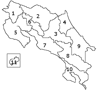
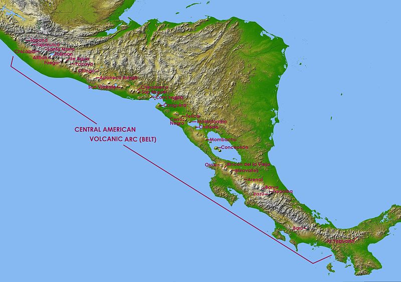
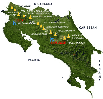

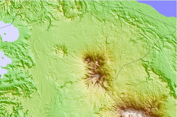
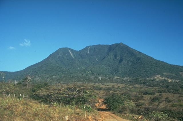
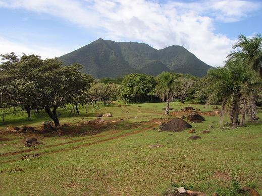
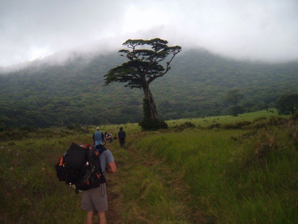
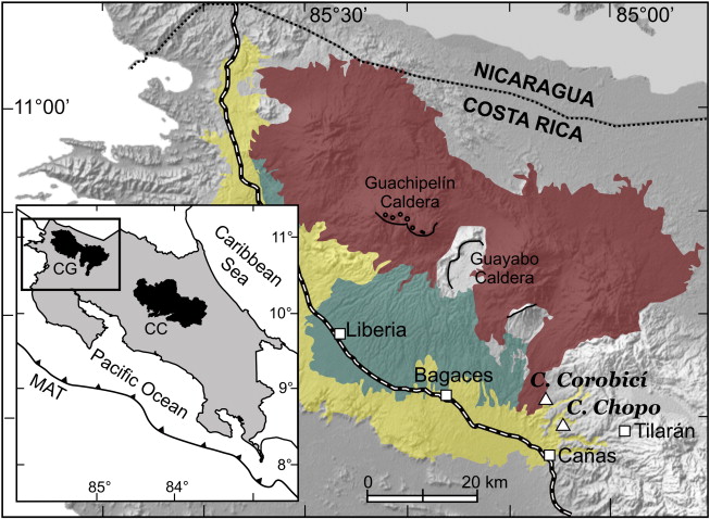
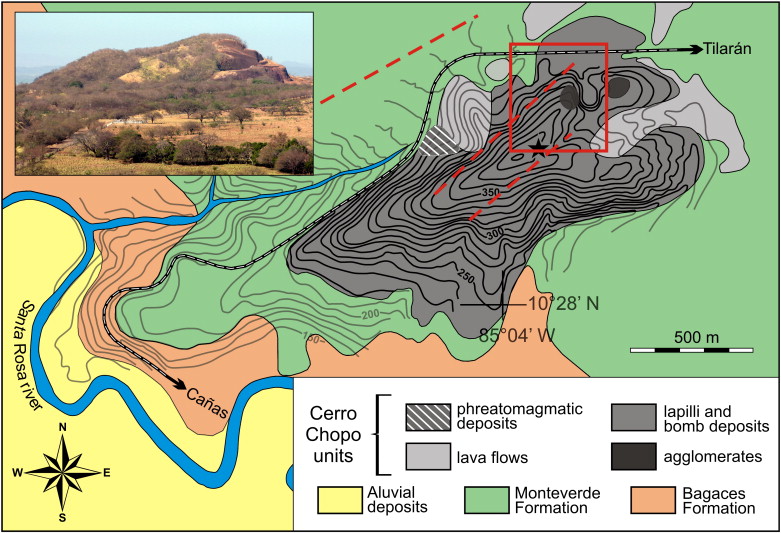
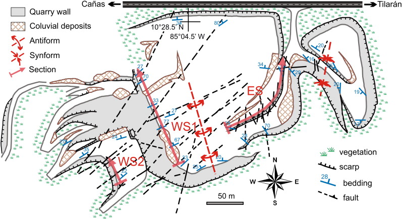
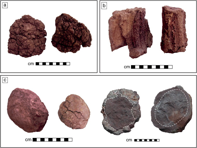
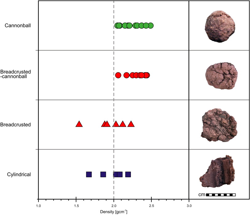
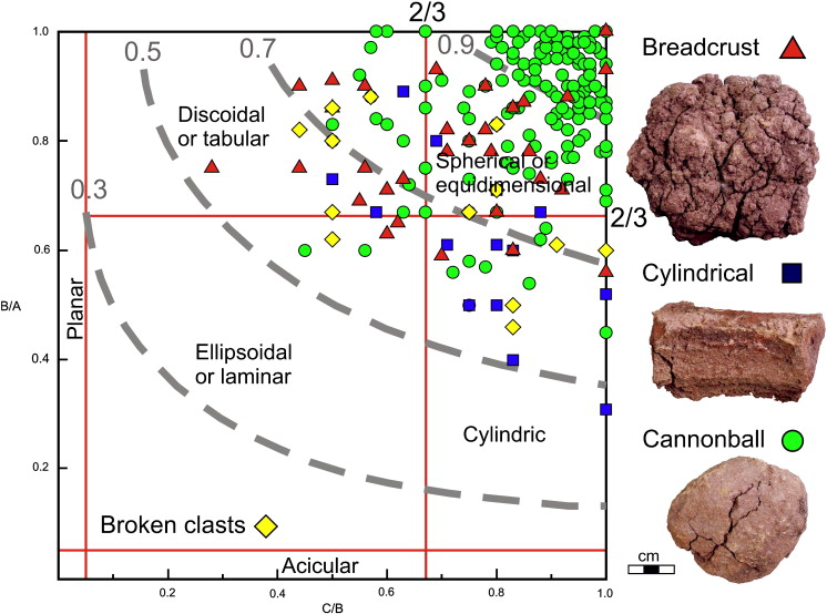
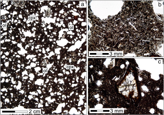
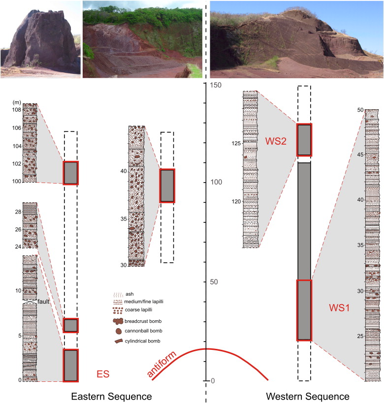
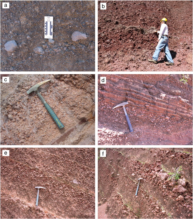

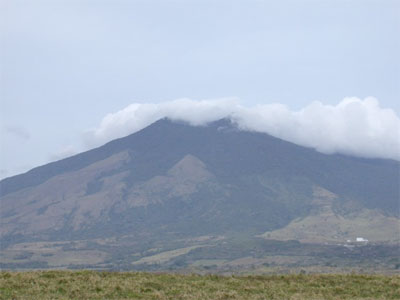
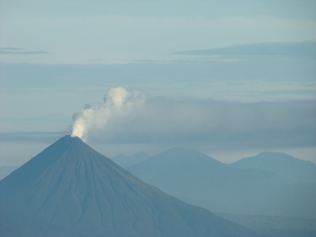
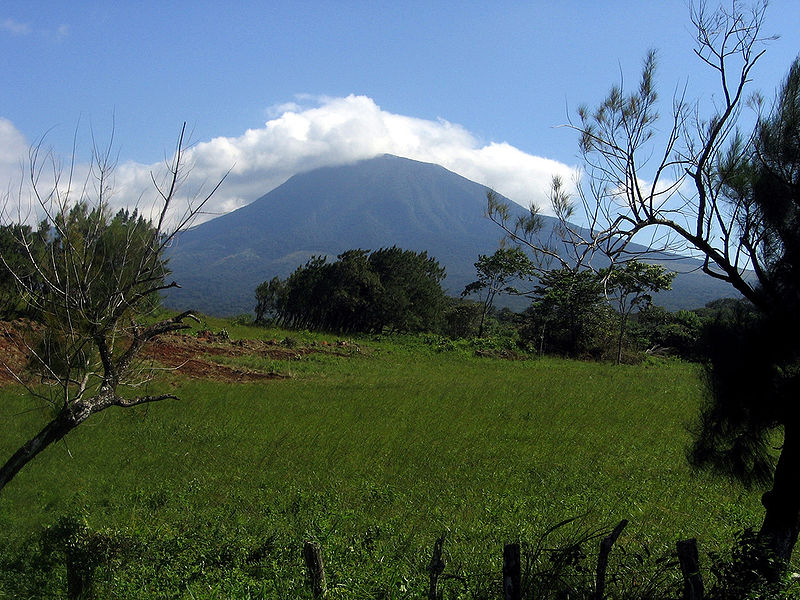
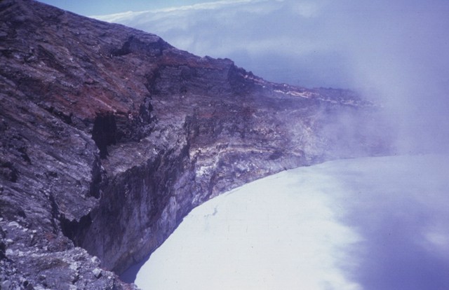
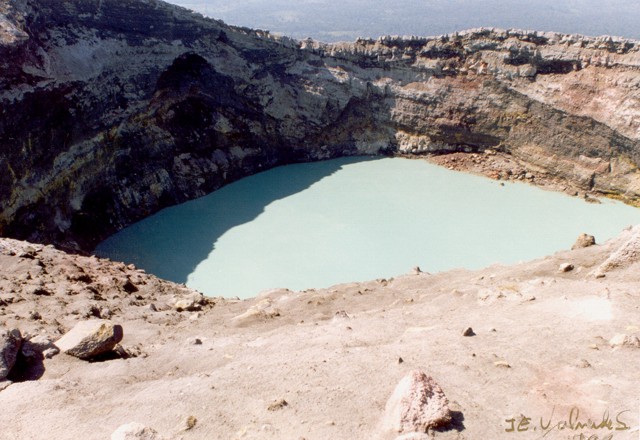
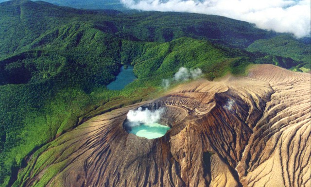
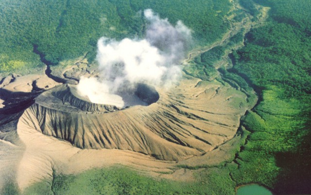
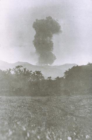
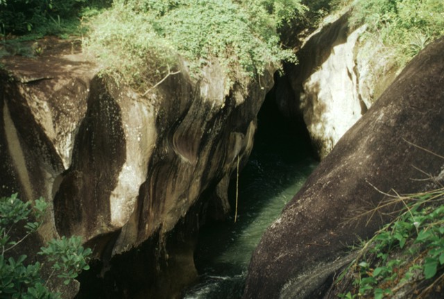
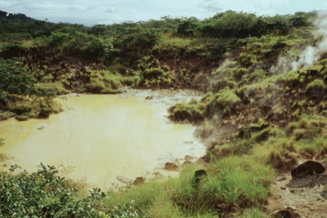
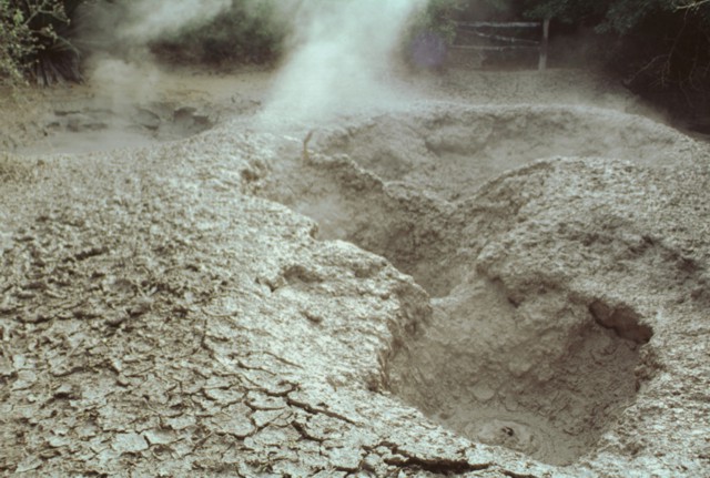
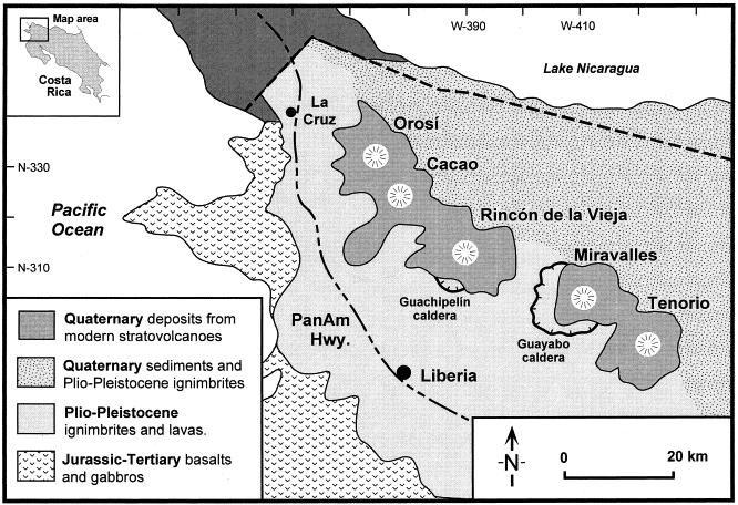
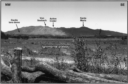
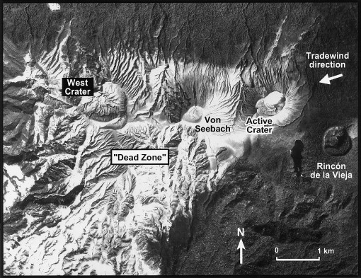
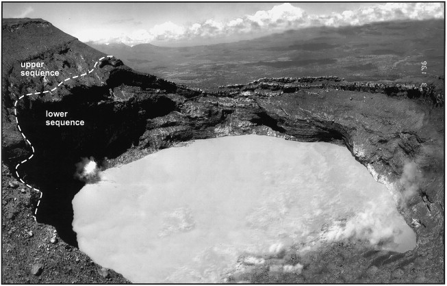
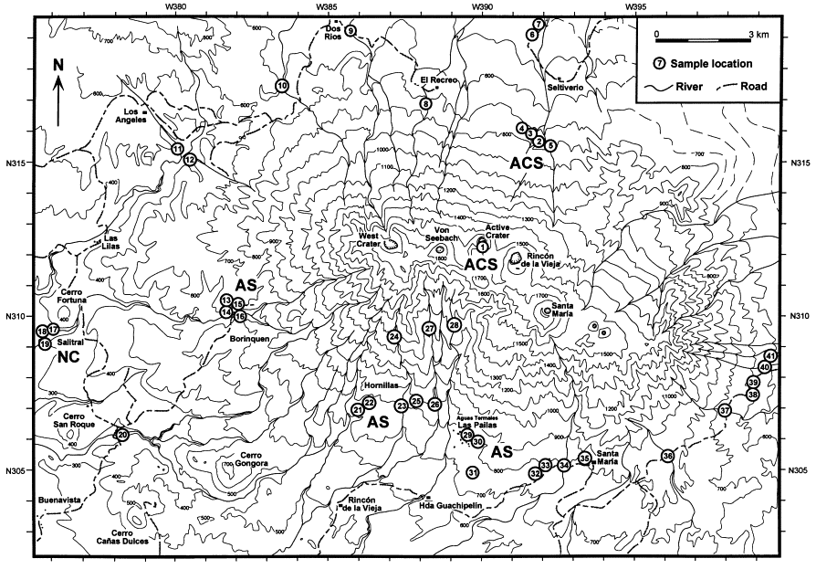
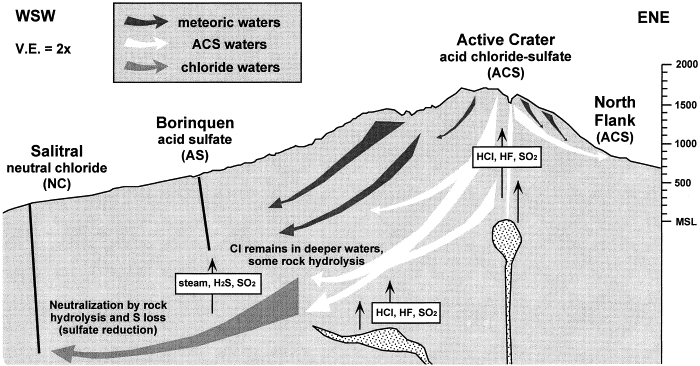
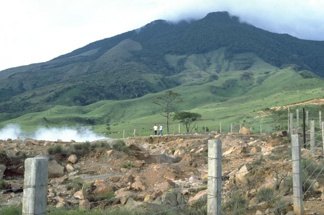
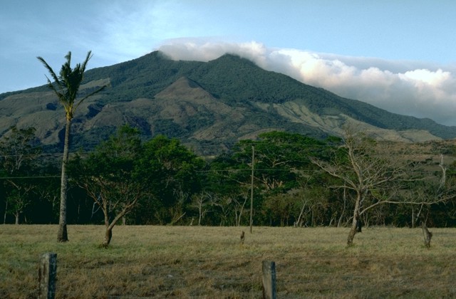
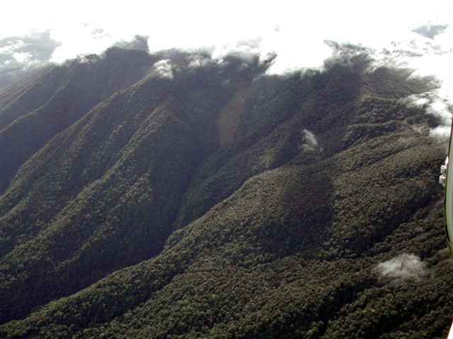
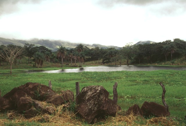
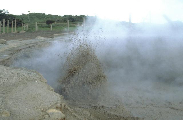
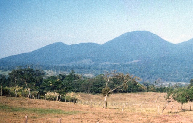
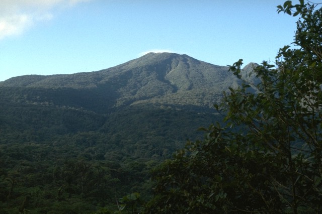
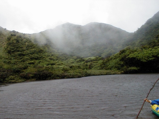
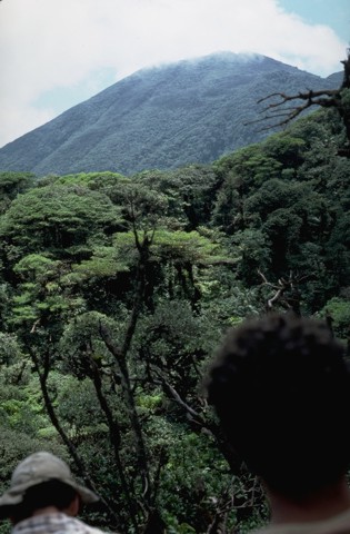
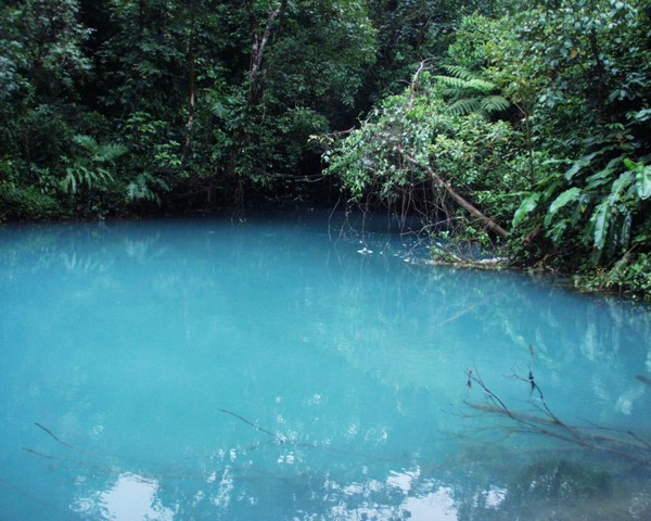
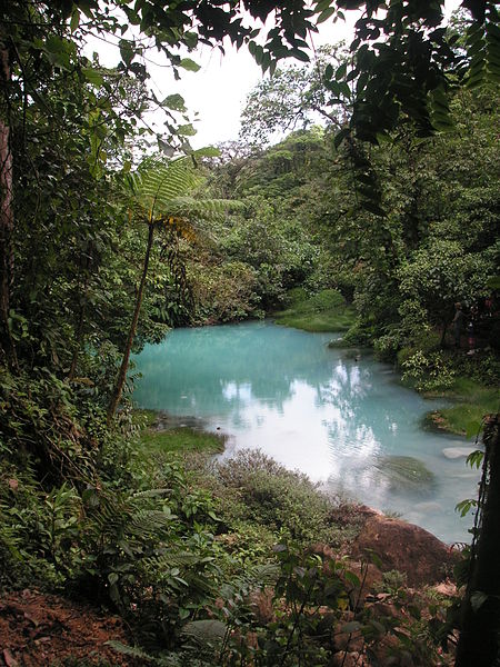
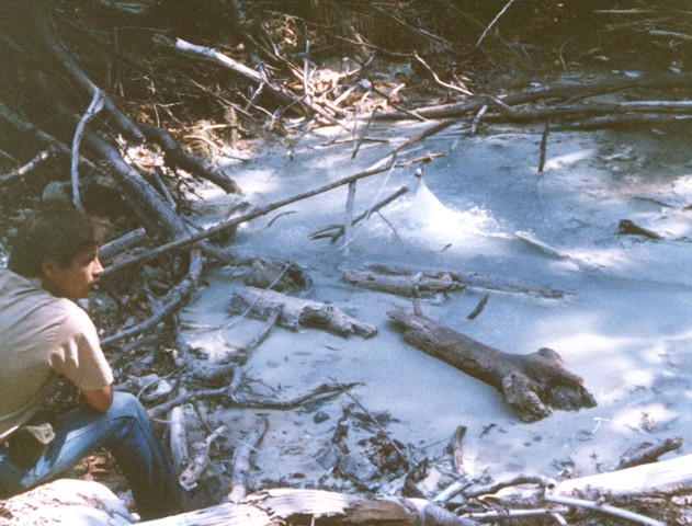
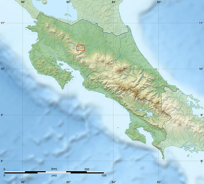
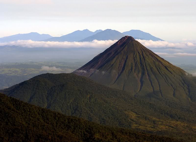
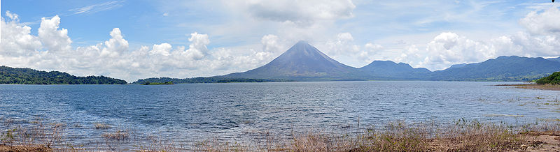
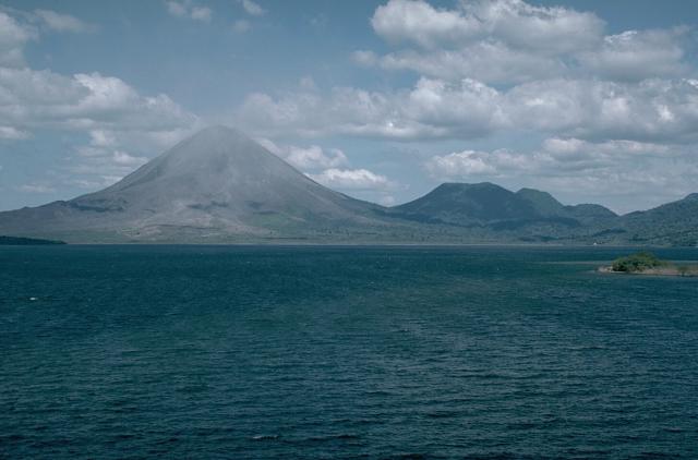
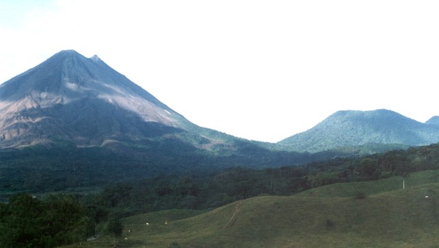
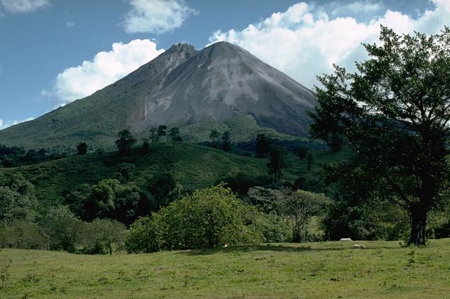
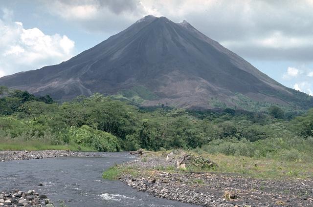
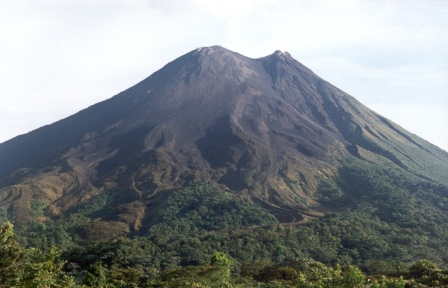
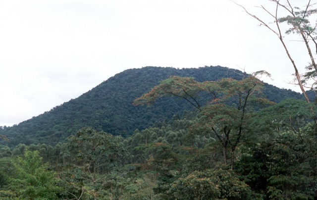
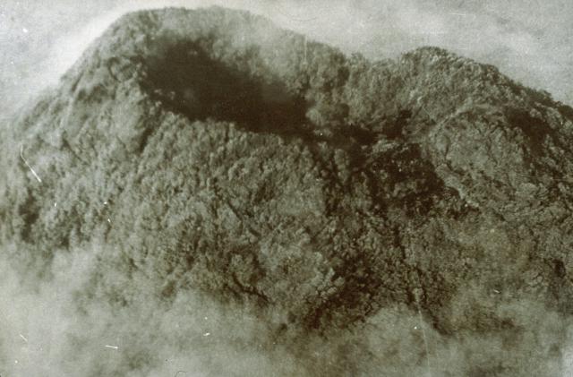
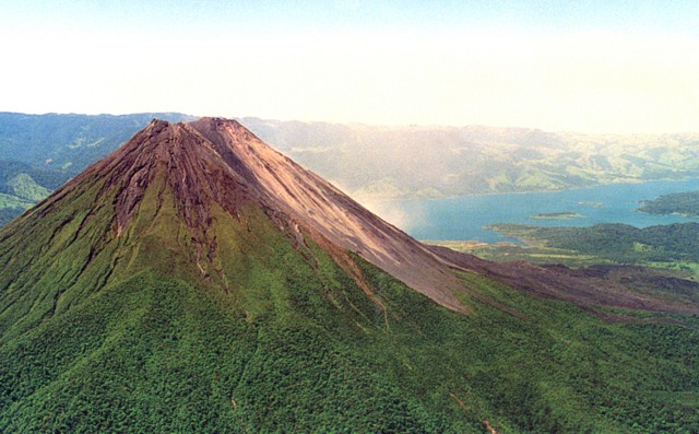
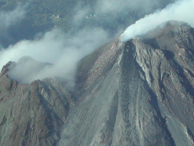
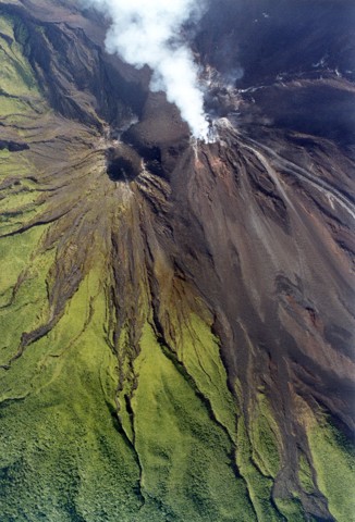
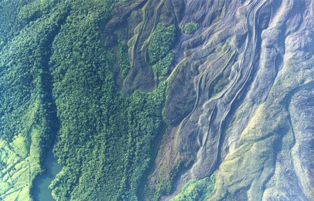
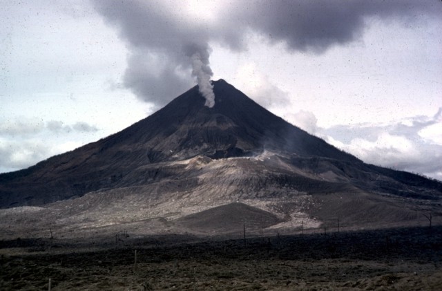
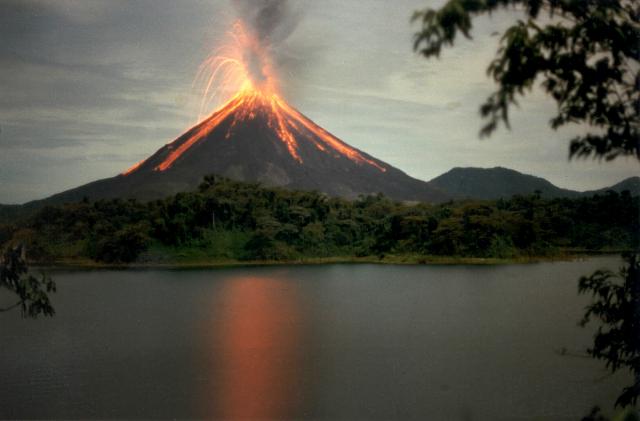
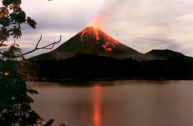
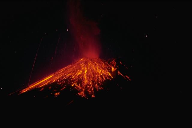
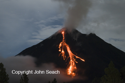
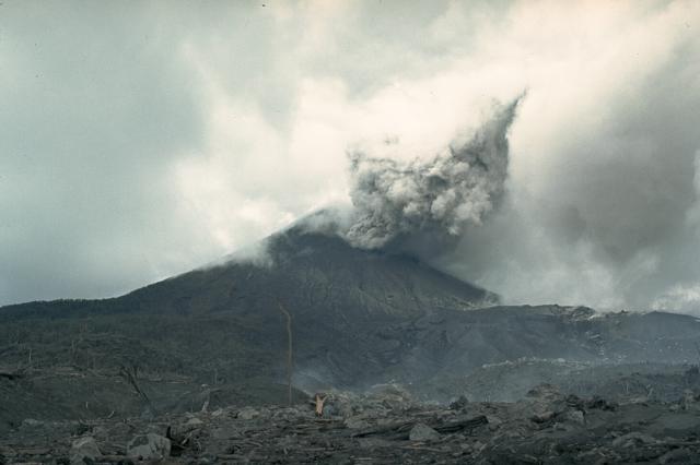
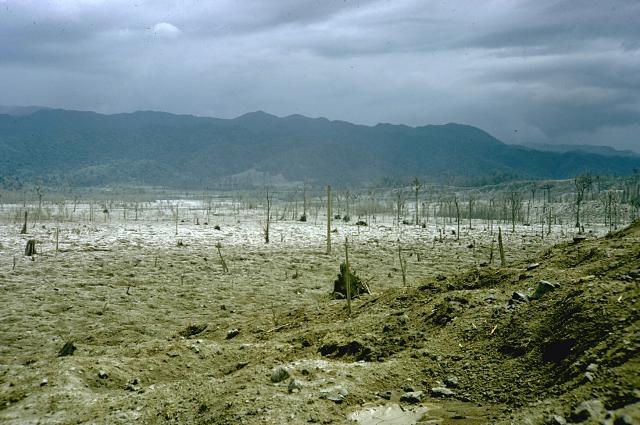
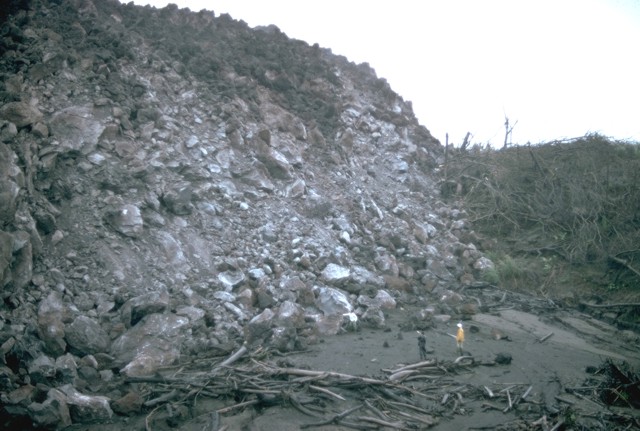
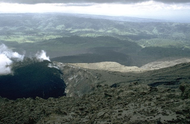
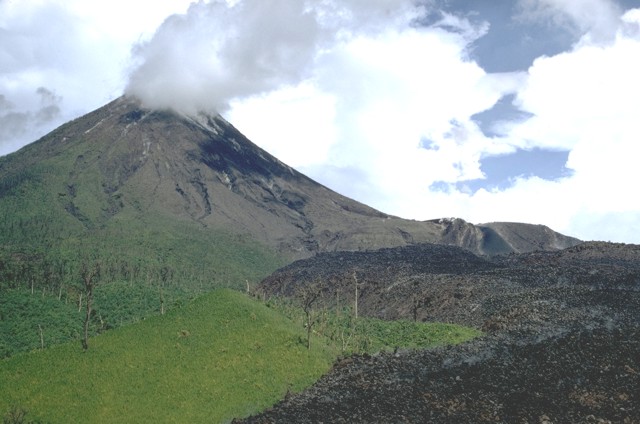
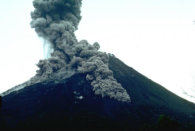
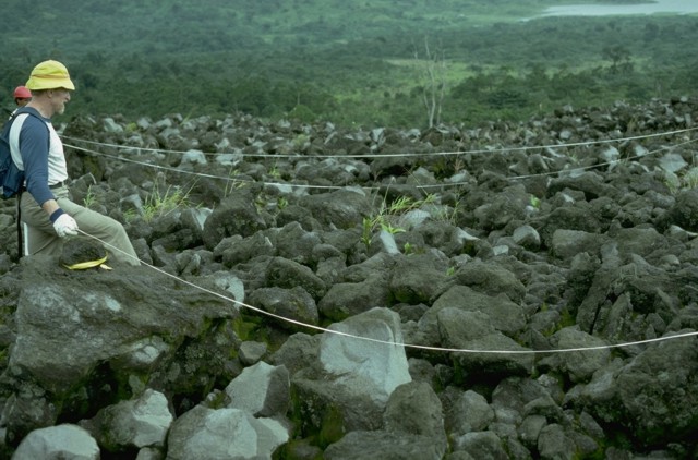
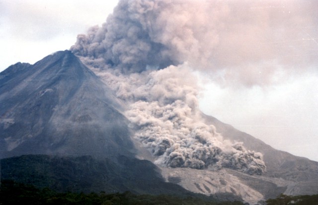
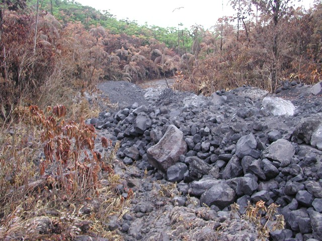
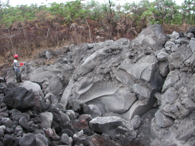
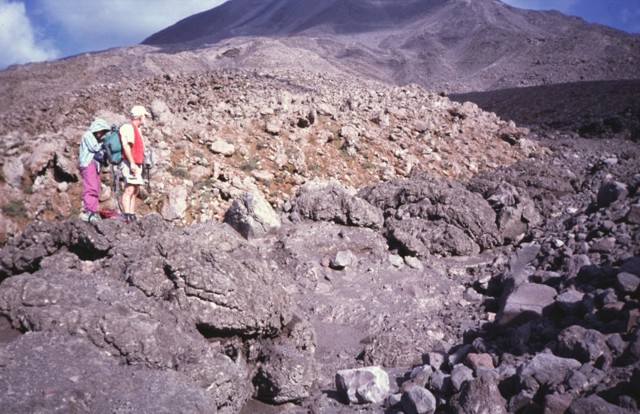
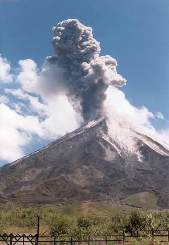
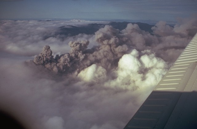
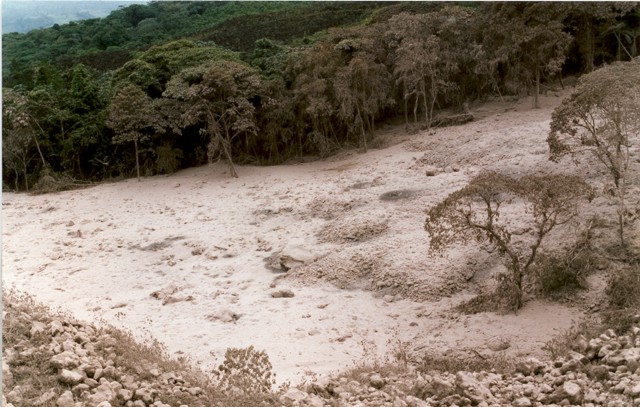
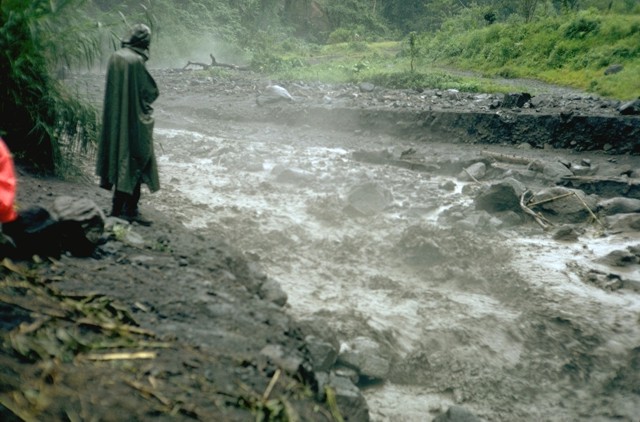
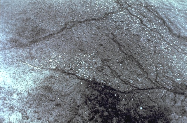
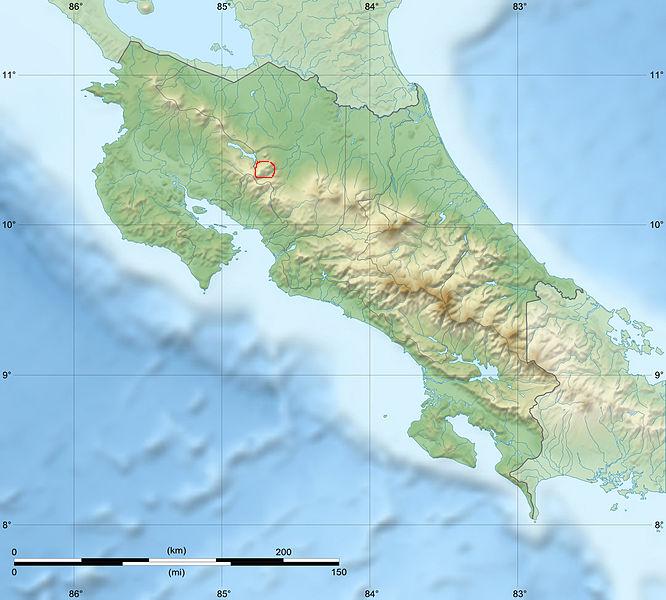
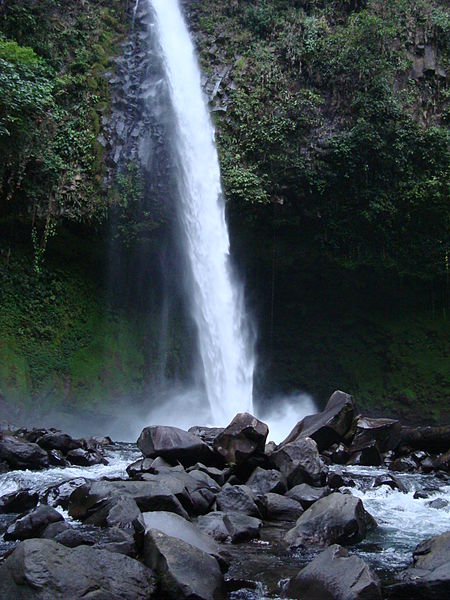
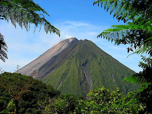
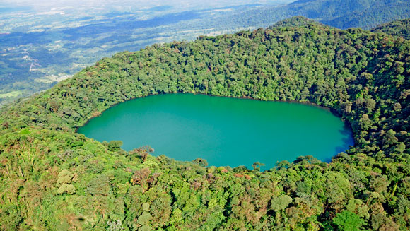
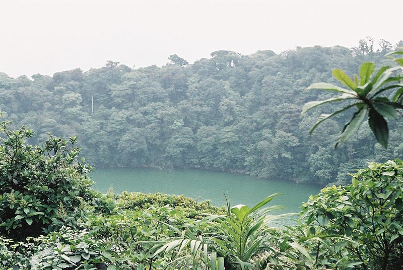
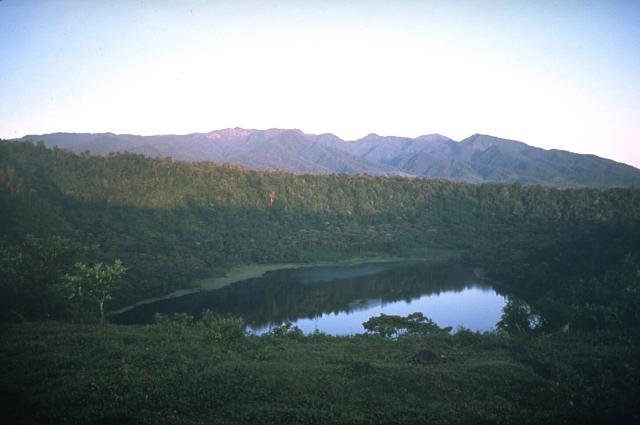
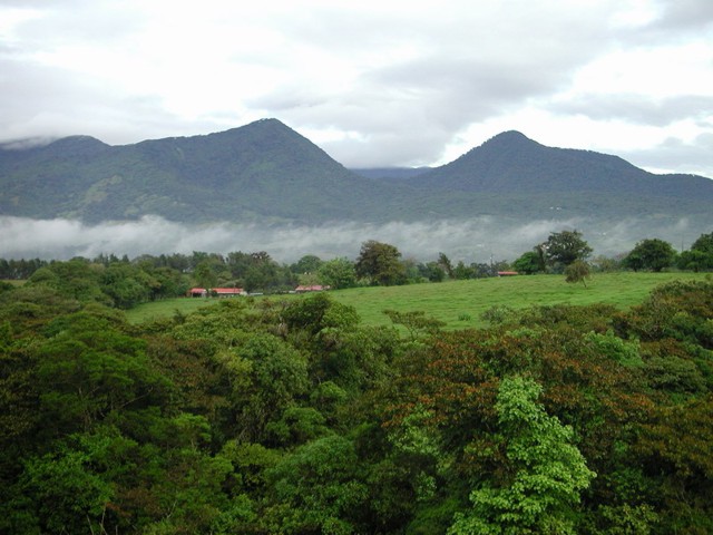
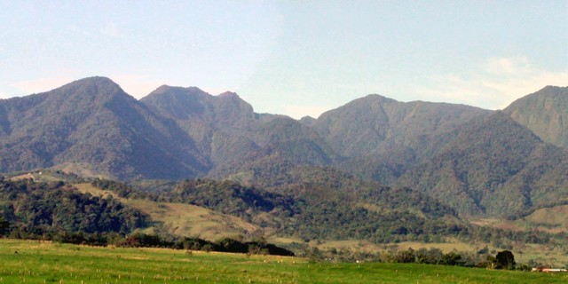
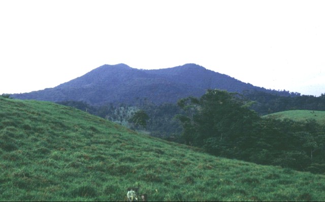
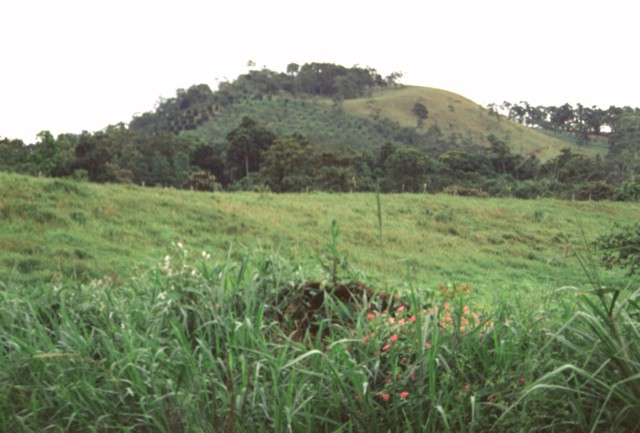
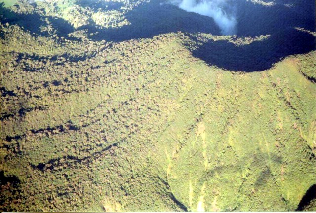
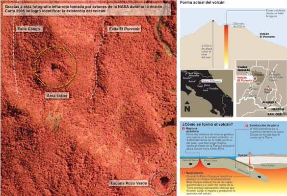
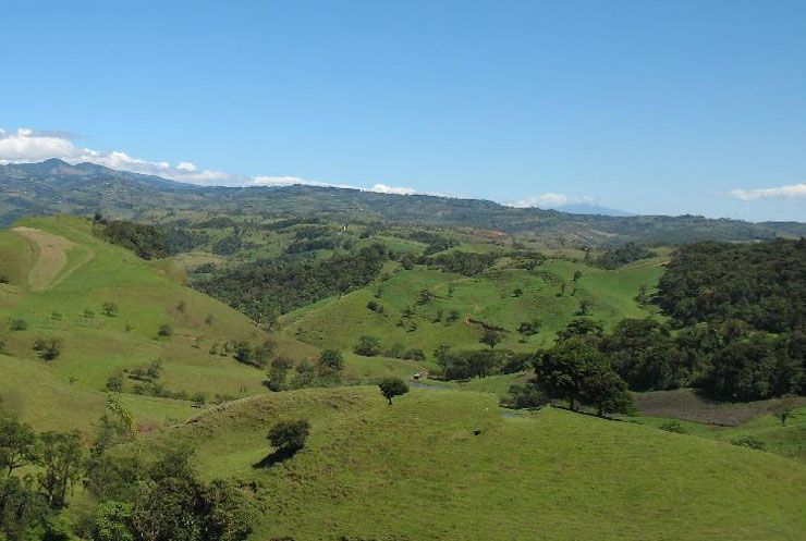
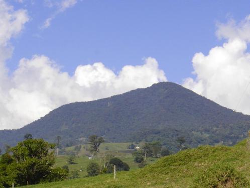
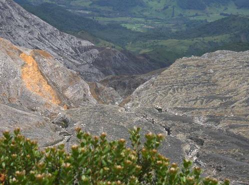
The Cordillera de Guanacaste, also called Guanacaste Cordillera, are a Quaternary volcanic mountain range in northern Costa Rica near the border with Nicaragua. The mountain range stretches 110 km from northwest to the southeast and contains mostly complex stratovolcanoes. The range as forms part of the southern region of the Continental Divide, with the highest peak is the stratovolcano Miravalles at 2,028 m.
Rivers flowing from the range drain into the Caribbean Sea (Guacalito, Zapote) and the Pacific Ocean (Blanco, Tenorio, Martirio, Corobiб and San Lorenzo).
Protected areas located in the mountain range include Guanacaste National Park established in July 1991 and Area de Conservacion Guanacaste World Heritage Site inscripted by UNESCO as a World Heritage Site in December 1999.
The range contains areas of ecological significance, as the Miravalles Forest Reserve, hills and canyons that can be seen from the lowlands of Guanacaste, areas rich with epiphytes, ferns and palms; and areas of geothermal activity, exploited for energy use. Geothermal energy exploited in Guanacaste account to 18% of Costa Rica''s electricity and is also exported to Nicaragua and Panama.
Cordillera de Guanacaste is divided into two sections:
1. La Cordillera Volcanica - formed by a series of volcanic edifices that begin with the Orosi Volcano and ends with the Arenal Volcano.
2. La Sierra Minera - depressions located between Arenal and Tapezco.
From http://en.wikipedia.org/wiki/Cordillera_de_Guanacaste
In Costa Rica there are 112 volcanic formations. They belong to so called Pacific Rim of Fire. Seven of them is considered as active ones. Their activity is connected with fertile soils, which cover the majority of Costa Rica territory. Their suddenly erruptions made in past years huge destructions. The highest Costa Rica`s volcanoe is Irazu, the most active is Arenal and Poas has the second widest crater in the world. (diameter 1,5 kilometres). In 1950`s, the terrains around each Costa Rican volcanoes were decided to be under protection. Many of them are within the national parks. Costa Rica major volcanic peaks are stratovolcanoes. The type of magma that fuels most Costa Rica volcanoes is thick, viscous, and so filled with gases that the erupting magma often blasts violently into the air. The most serious eruption was that of Irazu volcanoe in 1963. It erupted clouds of smoke and ash that kept shovering over San Jose and other parts for two years. People had been walking with handkerchief. From roofs on every day were being scraped layels of polders of even 13 centimetres thickness. Over 100 square kilometers of the surrounding land were devastated. The latest eruption in Costa Rica was of Arenal Volcanoe on August 24th, 2000. One person died and two were severly hurt. 600 residents have been evacuated.
Costa Rica Travel interactive map -http://www.costarica-vacation-getaway.com/vacation_rentals/169/costa_rica_volcano_s
National System of Conservation Areas
next
Costa Rica
Panama
Central America volcanoes photos