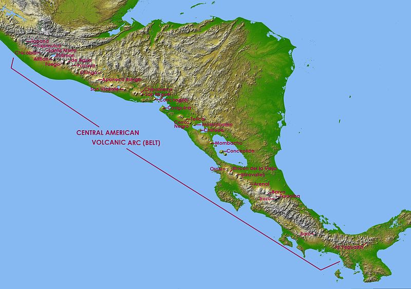
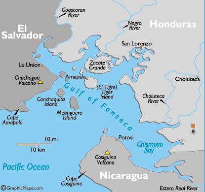
 | South CAVA |
|
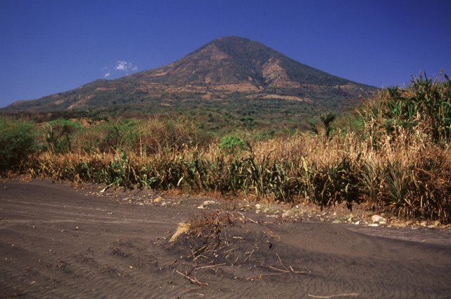
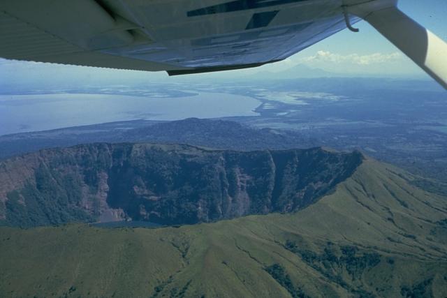
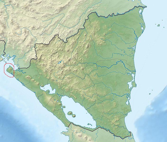
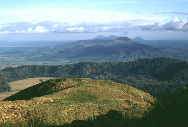
Conchagua. Conchagua, according to the Salvadorian geologist Walter Hernandez, is a volcano complex, which divides itself into two volcanic cones: Ocotal to the West and Banderas to the East. Ocotal is the oldest one and it''s been modified by several plates; therefore does not have the perfect cone shape. Banderas on the other hand is much younger and therefore well shaped. Both volcanoes have craters but Banderas'' is more evident. Local population refers to the volcanoes as "Cerro" (hill) since they elevate on a flatter surface. Much older volcanoes are sometimes not always recognized as volcanoes, due to their shape. For example, volcano Guazapa (older than Conchagua) can not be easily recognized as a volcano unless the person is related to vulcanology or geology.The volcanic complex of Conchagua shares some similarities with the volcanic complex in San Vicente, but the latter one has had more recent volcanic activity, therefore has better shaped cones. |
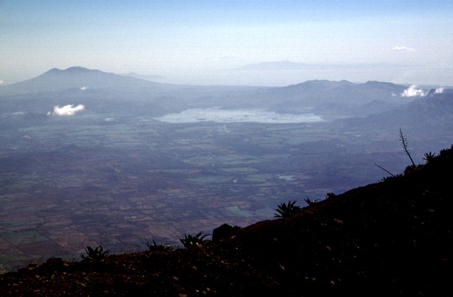
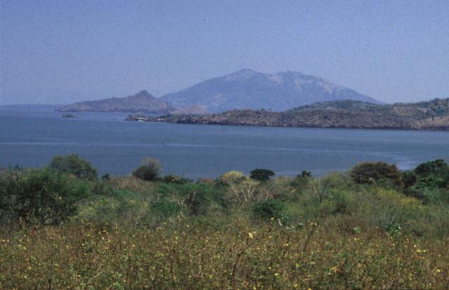
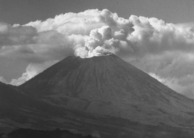
The twin peaks of Volcan Conchagua appear in the distance on the left horizon in this view to the east from the summit of San Miguel volcano. Conchagua lies on the shore of the Gulf of Fonseca at the SE tip of El Salvador. The large lake in the center of the photo is Laguna de Olomega. Flat-topped Cosiqьina volcano in Nicaragua is visible in the far distance at the upper right across the Gulf of Fonseca.http://www.volcano.si.edu/world/volcano.cfm?vnum=1403-11=&volpage=photos |
Conchagua Volcano |
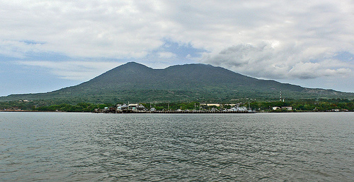
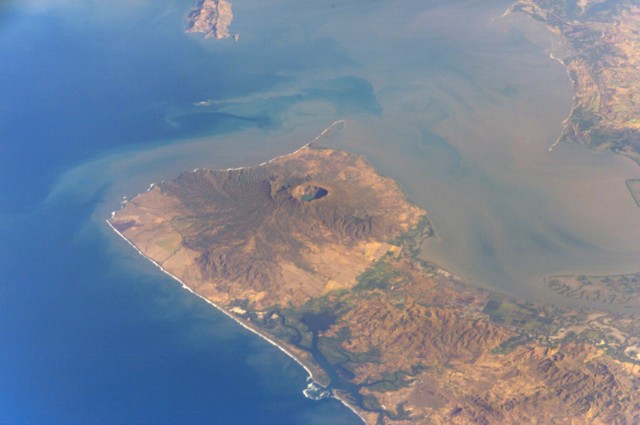
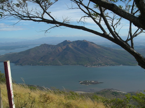
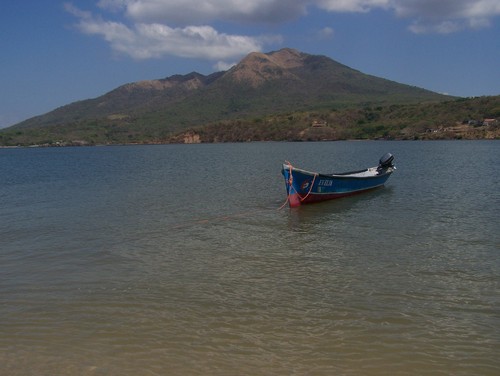
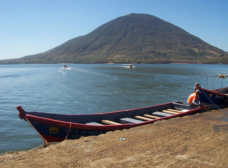
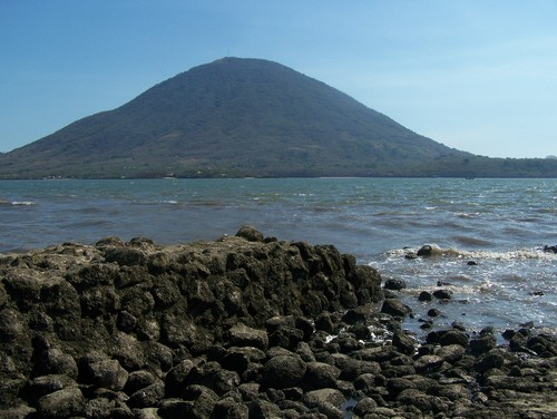
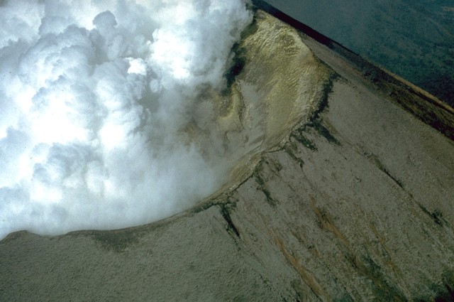
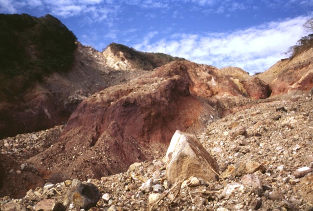
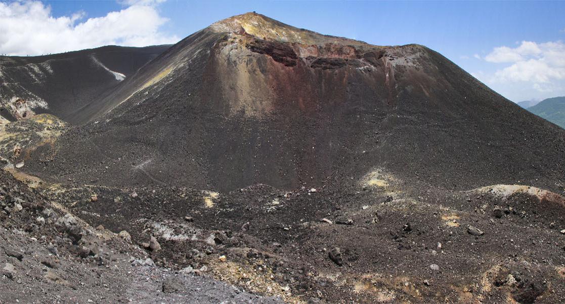
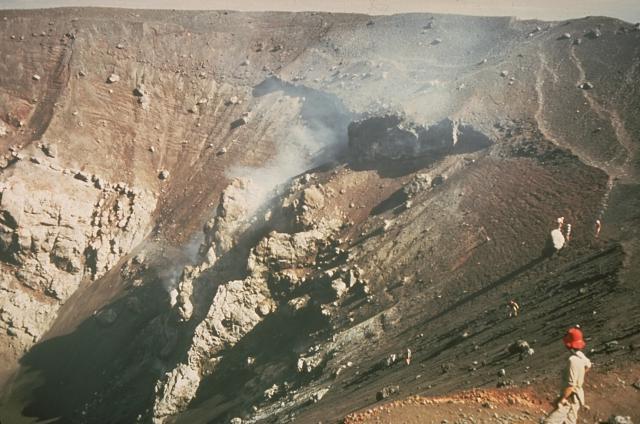
Conchagua volcano, 1225m, last eruption unknown, towers above sandy beaches along the Gulf of Fonseca at the SE tip of El Salvador.Conchagua (also known as Cochague) is a stratovolcano in southeastern El Salvador, overlooking the Gulf of Fonseca. Cerro del Ocote and Cerro de la Bandera are the two main summits, with Bandera appearing younger and more conical. There are active fumarolic areas on both peaks, but no confirmed historical eruptions. It is surrounded by forest called Bosque Conchagua. Conchagua is a conical, but deeply eroded stratovolcano overlooking the Gulf of Fonseca at the SE tip of El Salvador. Conchagua (also known as Cochague) is elongated in a WSW-ENE direction, and the eastern and southern flanks descend into the sea. Cerro de La Bandera, ENE of Cerro del Ocote, the 1225-m-high summit of Conchagua, appears to be younger in age. Multiple peaks mark the summit of Cerro del Ocote, whose flanks are more dissected than those of Cerro de La Bandera. Recently active fumarolic areas form barren spots on both major peaks of this little-studied volcano. Eruptions reported at Volcan Conchagua for the years 1522, 1688, 1868, and 1947 are erroneous, and may refer to landslides associated with earthquakes. Conchagua is a conical, but deeply eroded basaltic to basaltic-andesite stratovolcano bordering the Gulf of Fonseca at the SE tip of El Salvador. Cerro de la Bandera, east of Cerro del Ocote, the summit of Conchagua, appears to be younger in age. Recently active fumarolic areas form barren spots on both peaks. Eruptions reported in 1522, 1688, 1868, and 1947 are erroneous, and may refer to landslides associated with earthquakes. Conchagua volcano has a conical profile when seen from the NE near Punta el Chiriquнn. The volcano actually has a much more complex structure than seen here and has been extensively eroded. It has two principal summits. The eastern summit, Cerro de La Bandera, seen in this view, appears morphologically more youthful and is less dissected than Cerro del Ocote, which forms the 1225 m high point of the volcanic complex. Photo by Rick Wunderman, 1999 (Smithsonian Institution).- http://www.volcano.si.edu/world/volcano.cfm?vnum=1403-11=&volpage=photos |
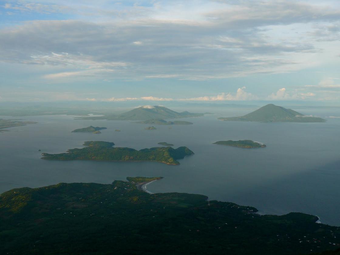
Conchaguita (left), an island in the Gulf of Fonseca, and Conchagua (right) a volcano on the Salvadoran mainland are seen here across the Gulf of Fonseca from the NE on the island of Zacate Grande in Honduras. Both Conchaguita and Conchagua are extensively eroded, but a historical eruption was reported from Conchaguita. The NW flank of Isla El Tigre volcano forms the ridge extending into the sea at the extreme left.Photo by Mike Carr, 1991 (Rutgers University).http://www.volcano.si.edu/world/volcano.cfm?vnum=1403-11=&volpage=photos |
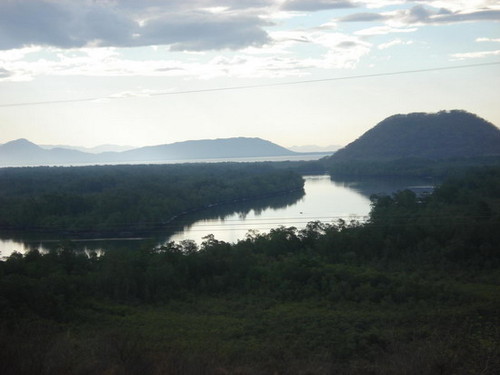
Conchaguita volcano. This volcano is in a island which is in the Gulf of Fonseca. The island in which the volcano is, is callled the Conchaguita island. Conchagua Volcano/Island Conchaguita Central Mountains Range |
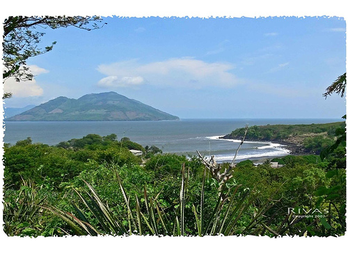
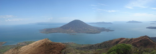
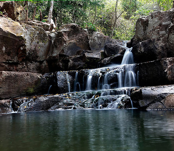
One of the best views of the Salvadorian coast can be seen from the Conchagua Volcano. From there you can also see the islands in the Gulf of Fonseca (Meanguera, Meanguerita, Amapala, among others). |
The photo was taken from the top of Conchagua |
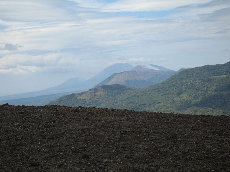
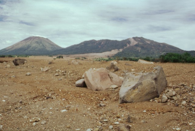
Cosiguina.An earthquake swarm occurred near the volcano in September 2002. This was the first seismic unrest at the volcano in 27 years. The largest earthquake magnitude 3.9 occurred on 9th September. The earthquakes were volcano-tectonic, caused by an intrusion of magma. On 2nd august 1951 a series of strong earthquakes produced a 200 m long crack near Cosiguina that ejected large amounts of water, causing a flood.The eruption of Cosiguina in 1835 was paroxysmal with ash falling on Mexico, Costa Rica and Jamaica. The eruption was heard in Jamaica and Colombia. The sun was blacked out for a radius of more than 150 km. The lapilli sized scoria fell 35 km from the volcano. Volume of ejected material was less than 10 cubic km. Eruptions 1859, 1852, 1835, 1809, 1709?, 1609? http://www.volcanolive.com/nicaragua.html |
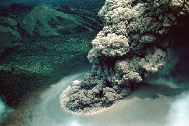
Cosiguina volcano forms the northern half of a 25-km-wide peninsula extending NW-ward into the Gulf of Fonseca. A 2-km-wide caldera, partially filled by a lake, truncates the summit of the volcano, and the scarp of a larger older caldera is visible to the NW. Pyroclastic flows from the catastrophic 1835 eruption, the largest in Nicaragua during historical time, reached the Gulf of Fonseca. The volcanic island of Meanguera in the El Salvador side of the Gulf of Fonseca is visible at the top left.Pyroclastic flows from the 1835 eruption reached the northern coast of the 20-km-wide Cosiguina Peninsula and formed new ephemeral islands in the Gulf of Fonseca. NASA Space Shuttle image ISS004-E-9143, 2002 (http://eol.jsc.nasa.gov/). |
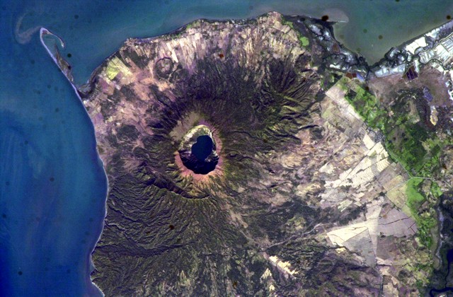
Cosiguina is a low basaltic-to-andesitic composite volcano that is isolated from other eruptive centers in the Nicaraguan volcanic chain. The 872-m-high stratovolcano forms a large peninsula extending into the Gulf of Fonseca at the western tip of the country. Cosiguina has a pronounced somma rim on the northern side; a young summit cone of Cosiguina rises 300 m above the northern somma rim and buries the rim on other sides. The younger cone is truncated by a large elliptical prehistorical summit caldera, 2 x 2.4 km in diameter and 500 m deep, with a lake at its bottom. Lava flows predominate in the caldera walls, although lahar and pyroclastic-flow deposits surround the volcano. In 1835 Cosiguina was the source of a brief, but powerful explosive eruption that was Nicaragua''s largest during historical time. The steep-walled, lake-filled summit caldera of Cosigьina volcano is prominent in this NASA Space Shuttle image with north to the upper left. Bahia el Rosario lies to the right of the elongate peninsula at the upper left with Punta San Jose at its tip, and the town of Potosi is at the top center. The scarp of an older caldera rim forms Filete Cresta Montosa, the semi-arcuate ridge below the summit caldera. This scarp continues in a more subdued form to the northern side of the volcano.NASA Space Shuttle image ISS006-E-51438, 2003 (http://eol.jsc.nasa.gov/). |
The summit of Cosiguina volcano, seen here from the west with the Gulf of Fonseca in the background and the border with Honduras at the upper left, contains a 2 x 2.4 km wide caldera with steep-sided, 500-m-high walls. The upper flanks of the volcano are only partially forested after a devastating eruption in 1835 produced pyroclastic flows and surges that reached the coast and fountain-fed lava flows that blanketed the upper eastern and western flanks. The peak in the distance below the right side of the wing is San Cristobal volcano.Photo by Jaime Incer, 1981. http://www.volcano.si.edu/world/volcano.cfm?vnum=1404-01=&volpage=photos |
Lagoon viewed from the crater. Cosiguina, is a stratovolcano located in the western part of Nicaragua. It forms a large peninsula extending into the Gulf of Fonseca. The summit is truncated by a large caldera, 2 x 2.4 km in diameter and 500 m deep, holding a substantial crater lake (Laguna Cosiguina). This cone has grown within an earlier caldera, forming a somma volcano. The earlier caldera rim is still exposed on the north side, but has been buried by the younger cone elsewhere. The volcano last erupted in 1859, but its most famous activity occurred on 20 January 1835, when it produced the largest historical eruption in Nicaragua. Ash from the 1835 eruption has been found in Mexico, Costa Rica, and Jamaica.The volcano has been quiet since 1859, only an instant in terms of geological time. An earthquake swarm was measured near Cosiguina in 2002, indicating that tectonic forces are still active in the region although the volcano is somewhat isolated from the line of more recently active Central American volcanoes to the northwest and southeast. The only indicators of hydrothermal activity at the volcano are intermittently observed gas bubbles in Laguna Cosiguina and a hot spring along the eastern flank of the volcano. The fairly uniform vegetation cover on the volcano�s sides also attests to a general lack of gas emissions or �hot spots� on the 872-meter-high cone - http://en.wikipedia.org/wiki/Cosig%C3%BCina |
The steep-sided caldera walls of Cosiguina volcano rise 500 m above a lake on the caldera floor. Inter-bedded gray lava flows and brownish pyroclastic deposits forming the pre-caldera stratovolcano are exposed in the far wall. Observers of Cosiguina prior to the catastrophic 1835 eruption described the volcano as being of low height, with a flat top, suggesting that the caldera was in existence prior to the eruption.Photo by Jaime Incer http://www.volcano.si.edu/world/volcano.cfm?vnum=1404-01=&volpage=photos |
Cosiguina |
|
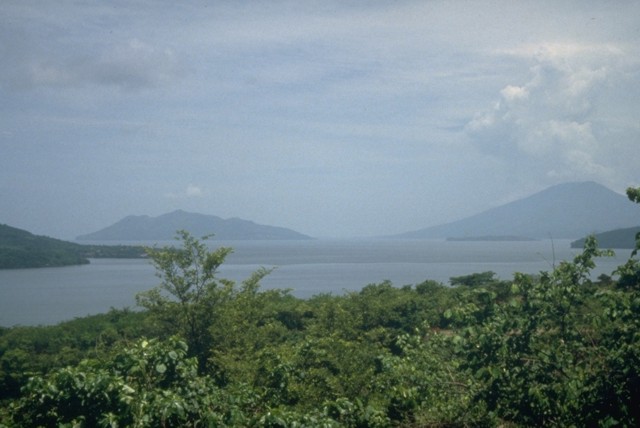
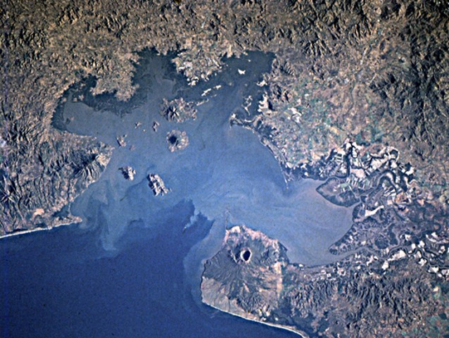
Cosiguina and young volcanoes dot the surface and anchor the shores of the Gulf of Fonseca, which forms the coastline of three countries. Conchagua volcano occupies the wedge-shaped peninsula (left-center) in eastern El Salvador, while Cosigьina volcano forms the prominent peninsula across the bay in Nicaragua. Clockwise from the top are the islands of Zacate Grande and El Tigre in Honduras and Meanguera and Conchaguita in El Salvador. The mouth of the Gulf of Fonseca is about 30 km wide.NASA Space Shuttle image STS82-731-83, 1997 (http://eol.jsc.nasa.gov/), http://www.volcano.si.edu/world/volcano.cfm?vnum=1403-13-&volpage=photos |
Isla Zacate Grande, Gulf of Fonseca, Honduras, coordinate 13o20�N 87o50�W, Range CAVA, elevation 640m, Holocene stratovolcano. The volcano forms a 7 x 10 km wide island and has seven satellite cones, including Guegensi Island located 3 km from Zacate Grande.Zacate Grande volcano forms a low 7 x 10 km wide island across a narrow strait from the end of a peninsula surrounded on three sides by the Gulf of Fonseca and Chismuyo bay. At least seven satellitic cones, some of which form small islands offshore, are located from the NE to SE base of the broad 640-m-high basaltic stratovolcano. Some of these, including the symmetrical cone of Isla Gueguensi in the tidal flats about 3 km east of the base of Zacate Grande, are of probable Holocene age (Carr 1992, pers. comm.). In contrast to neighboring Isla El Tigre volcano to the south, Zacate Grande itself is extensively eroded, and deep valleys extend from the summit ridges to the base of the volcano.Photo by Rick Wunderman, 1999 (Smithsonian Institution).http://www.volcano.si.edu/world/volcano.cfm?vnum=1403-14-&volpage=photos |
Zacate Grande viewed from El Tigre Volcano - http://www.summitpost.org/gulf-fonseca/images/p-512828 |
Zacate Grande from a small island south of El Tigre -http://www.summitpost.org/gulf-fonseca/images/p-512828 |
"Volcan Del Tigre" viewed from "Sacate Grande volcano", both are in middle of the water in the Pacific Ocean. And are in the corner of 3 countries: Nicaragua, Honduras and El Salvador |
El Tigre, seen from Coyolito, the Gulf of Fonseca, a body of water on the Pacific coast of Central America. Isla el Tigre, coordinate 13o13�N 87o38W, elevation 783m, Holocene conical basaltic stratovolcano , eruptions unknown.Isla El Tigre is a small, 5-km-wide island located across a narrow 2-km-wide strait south of Isla Zacate Grande in the Gulf of Fonseca. The conical, 783-m-high basaltic stratovolcano is the southernmost volcano of Honduras. El Tigre is less dissected than neighboring Zacate Grande volcano on the mainland to the north and is of probable Holocene age (Carr 1992, pers. comm.). A single satellitic cone, El Vigнa, overlooks the village of Amapala on the NW flank -http://www.volcano.si.edu/world/volcano.cfm?vnum=1403-13-&volpage=photos |
El Tigre from the docks at Coyolito on the mainland. Basalt lying in fields of this little island remind one of past volcanic history with El Tigre looming in the background. |
This is a former lava flow, one of the many signs that show how active the area around El Tigre was |
Gulf Fonseca -http://www.summitpost.org/gulf-fonseca/images/p-512828 |
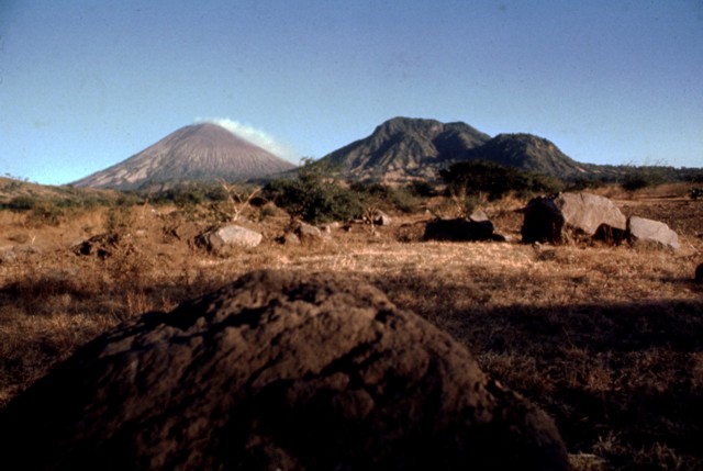
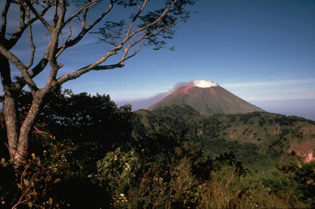
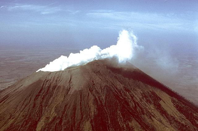
San Cristobal is the highest volcano in Nicaragua at 1,745 m. It is also among the most active volcanos in Nicaragua, erupting frequently.San Cristobal is part of a 5-member volcanic complex that bears the same name. Chonco lies 4 km to the west, and Moyotepe 4 km to the north east. Joined to the volcano''s eastern flank is Volcan Casitas, which buried a village with a catastrophic landslide in 1998. The scars from said landslide are still visible today. Finally, La Pelona is located on the eastern end of the complex.San Cristbal, 1745m, is the youngest volcano in its complex. It is a nearly symmetrical stratovolcano, rising in a distinctive cone shape. The SW slope is the longest, and the crater rim on that side rises 140 m above the NE end due to prevailing trade winds that distribute tephra to the SW. The crater is 500x600 m in size. While the volcano was at one point covered in tropical forests, the large quantities of gas and smoke that it emits constantly have killed off much of the vegetation. Range Cordillera Los Maribios. http://en.wikipedia.org/wiki/San_Crist%C3%B3bal_volcano |
The oldest volcanic center of the San Cristobal volcanic complex is La Pelona caldera, whose eastern wall forms the forested ridge in the center of the photo. Formation of the caldera was accompanied by the eruption of large amounts of dacitic pumice. Part of the caldera floor is visible at the left, but the western rim and floor has been buried by products of Casita volcano, where this photo was taken. The Marrabios Range volcanoes of Telica, Las Pilas, and conical Momotombo can be seen in the distance.Photo by Lee Siebert, 1998 (Smithsonian Institution).http://www.volcano.si.edu/world/volcano.cfm?vnum=1404-02=&volpage=photos |
Cordillera de Maribios (or Cordillera de Marrabios) is a mountain range in Leon about 64.4 km (40 mi) long. It is a volcanic range comprised most notably by San Cristobal 1745 m, Pilas 983 m, Telica 1060 m, Cerro Negro 450 m, and Momotombo 1258 m http://en.wikipedia.org/wiki/Cordillera_de_los_Maribios |
Boulders litter the foreground in this 1977 view of steaming San Cristobal (left horizon) and Volcan El Chonco (right horizon). Immediately to the right of El Chonco on its western flank is Loma la Teta, a dacitic lava dome that postdates the collapse. Another small dome, Loma Caparra (barely visible here left of El Chonco and in front of the steaming San Cristobal volcano in the background) was extruded on the northern flank of El Chonco. The 1105-m-high El Chonco lies at the western end of the San Cristobal volcanic complex.Photo by Alain Creusot-Eon, 1977 (courtesy of Jaime Incer). http://www.volcano.si.edu/world/volcano.cfm?vnum=1404-02=&volpage=photos |
The steaming summit crater of San Cristobal volcano is viewed here from the top of Casita volcano, whose western crater rim forms the ridge at the lower left. The SW crater rim (upper left) is 140 m above the NE rim, reflecting the influence of trade winds on tephra deposition. The 500 x 600 m wide crater is elongated in an E-W direction, and is several hundred meters deep.Photo by Paul Kimberly, 1998 (Smithsonian Institution).The San Cristobal volcanic complex towers above the Plain of Leon to its south. A vigorous steam plume rises in 1978 above San Cristobal (El Viejo) volcano at the left, the most recently active volcano of the complex. The irregular summit of Casita volcano (right) was formed by eruptions from several independent, partially overlapping craters along an E-W axis. Seven fumarolic areas are widely scattered over Casita volcano, which is also known as Chichigalpa.The irregular summit of Casita volcano (right) was formed by eruptions from several independent, partially overlapping craters along an E-W axis. Seven fumarolic areas are widely scattered over Casita volcano, which is also known as Chichigalpa. http://www.volcano.si.edu/world/volcano.cfm?vnum=1404-02=&volpage=photos |
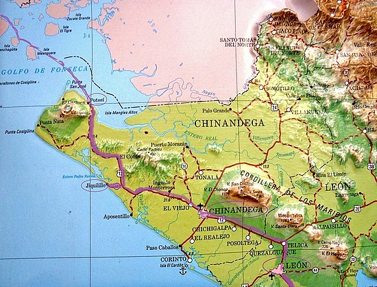
Steam clouds blown to the west by trade winds pour from the summit crater of San Cristobal in 1977 and blanket the volcano''s flanks. The slopes of El Chonco, an eroded stratovolcano at the western end of the San Cristуbal complex, are seen at the right above cotton fields in the foreground. Several lava domes are found near the base of El Chonco, which also produced a 9-km-long lava flow that extends to within 1.5 km of the city of Chinandega, SW of the volcano.Photo by Jaime Incer, 1977. http://www.volcano.si.edu/world/volcano.cfm?vnum=1404-02=&volpage=photos |
The San Cristobal volcanic complex, consisting of five principal volcanic edifices, forms the NW end of the Marrabios Range. The symmetrical 1745-m-high youngest cone, named San Cristobal is capped by a 500 x 600 m wide crater. El Chonco, with several flank lava domes, is located 4 km to the west of San Cristobal; it and the eroded Moyotepe volcano, 4 km to the NE of San Cristуbal, are of Pleistocene age. Volcбn Casita, containing an elongated summit crater, lies immediately east of San Cristobal and was the site of a catastrophic landslide and lahar in 1998. The Plio-Pleistocene La Pelona caldera is located at the eastern end of the San Cristуbal complex. Historical eruptions from San Cristobal, consisting of small-to-moderate explosive activity, have been reported since the 16th century. Some other 16th-century eruptions attributed to Casita volcano are uncertain and may pertain to other Marrabios Range volcanoes. The San Cristobal volcanic complex consists of five principal edifices. The youngest cone, the namesake San Cristbal, seen here from the south, is the highest peak of the Marrabios Range. Several radial flank craters occur along a N-S line on the outer north flank of 1745-m-high San Cristobal. Historical activity, consisting of small-to-moderate explosive eruptions, has been reported since the 16th century. The SW crater rim (left) rises 140 m above the NE rim because prevailing trade winds distribute tephra to the SW.Photo by Jaime Incer.San Cristobal volcano, one of the most dramatic landmarks in Nicaragua, rises to 1745 m above cotton fields on its southern flank. This 1975 view of the volcano, also known as El Viejo, shows a strong gas plume drifting down its western flank. Persistent fuming has released large amounts of sulfur dioxide, destroying forests on this side of the volcano; the gas plume was strong enough to corrode barbed wire. Lava flows and explosive activity have occurred from lateral vents as well as from the large summit crater. http://www.volcano.si.edu/world/volcano.cfm?vnum=1404-02=&volpage=photos |
San Cristobal, seen in this 1975 aerial view from the south, is the highest volcano in the Marrabios Range of western Nicaragua. The symmetrical, 1745-m-high stratovolcano is the youngest of five principal volcanoes forming the San Cristobal complex. Young lava flows are located on its SW and northern flanks. Explosive eruptions have occurred since the beginning of the Spanish era. Cerro Moyotepe, a small composite volcano of the San Cristуbal complex that is cut by a series of N-S faults, appears at the right, below the plane wing.Photo by Jaime Incer, 1975.http://www.volcano.si.edu/world/volcano.cfm?vnum=1404-02=&volpage=photos |
A vigorous steam plume pours from the summit crater of San Cristobal volcano in December 1971, following an eruption that began on May 3. This mild explosive eruption lasted until early July. The 1971 activity marked the first documented eruptive activity at San Cristobal since the 17th century. The volcano is seen here from the El Limуn gold mine east of the volcano.Copyrighted photo by Dick Stoiber, 1971 (Dartmouth College). http://www.volcano.si.edu/world/volcano.cfm?vnum=1404-02=&volpage=photos Eruptive history: 1685: Erupted strongly enough to merit preservation in historical accounts, August 1919: Produced loud noises and light tremors that were felt in surrounding areas, May 1971: Produced bangs and explosions, March 1976: Produced a high, continuous column of smoke, several light tremors, and explosions that occurred every three minutes, c. December 1986: Marked expulsion of gases, c. January 1987: Expelled large quantities of gas, May 1997: Entered into a new eruptive period, expelling gases, ash, and sand, and also producing light tremors, December 1999: Expelled gas, ash, and sand, May, August 2001: Reactivated, April 2006: Moderate phreatic eruption, July 2008: Rumbled with a series of small explosions, and expelled gas, September 2009: Explosion and moderate ash expulsion, September 2012: Three big explosions, expelled gas, ash and sand to 5,000 metres, following the 2012 Costa Rica earthquake, Current activity: San Cristobal remains quite active, continuously expelling copious amounts of gas and smoke. As recent as September 2009, it was reported that ash was falling in nearby towns. In September 2012 it erupted again, spewing ash up to four kilometres (2.5 miles) into the atmosphere, resulting in the evacuation of around 3000 people in the surrounding area.2012 Eruption Eruptions occurred at San Cristobal volcano on 8th September 2012. Ash emissions reached 5000 m above the crater rim, and drifted 50 km west-north-west. Sulphur dioxide emissions reached 3200 tons per day compare to a normal emission of 550-700 tons per day. On the northwest sector of the volcano incandescent material caused burns to six livestock. 2008 Eruptions |
Steaming San Cristobal volcano rises to the WNW beyond the rim of La Ollada, the 1-km-wide crater of Casita volcano. Fumarole activity along the northern wall of La Ollada has persisted since the early 16th century and does not exceed a temperature of 100 degrees Centigrade. This photo was taken from the summit of Casita volcano.Photo by Alain Creusot-Eon, 1975 (courtesy of Jaime Incer).http://www.volcano.si.edu/world/volcano.cfm?vnum=1404-02=&volpage=photos |
A strong steam plume pours from the summit crater of San Cristobal volcano in this March 1976 view from the NW. Mild explosive eruptions during March 9-16, 1976 were the first since 1971. In February 1972 part of the crater floor began subsiding, ultimately leading to formation of a collapse pit in March 1976. By December 1976 the pit had deepened to 90 m and incandescence was visible after dark. A vigorous white steam plume, seen here from the NW, rises from the summit crater of San Cristobal volcano in March 1976. Small ash eruptions occurred from San Cristobal on March 9-10, 1976, dropping ash on the town of Chinandega, 10 km to the SW. Ashfall from another eruption on March 16 was restricted to the summit crater area. Collapse of cones within the summit crater during this eruption created a new 300-m-wide vent.http://www.volcano.si.edu/world/volcano.cfm?vnum=1404-02=&volpage=photos |
The steaming summit crater of San Cristobal volcano is viewed here from the top of Casita volcano, whose western crater rim forms the ridge at the lower left. The SW crater rim (upper left) is 140 m above the NE rim, reflecting the influence of trade winds on tephra deposition. The 500 x 600 m wide crater is elongated in an E-W direction, and is several hundred meters deep.Photo by Paul Kimberly, 1998 (Smithsonian Institution).http://www.volcano.si.edu/world/volcano.cfm?vnum=1404-02=&volpage=photos |
Steam clouds fill much of the crater of San Cristobal volcano in March 1976. After a quiescence of about five years, small ash eruptions took place at San Cristobal on March 9-10, 1976, dropping ash on the nearby town of Chinandega. During an eruption on March 16 ash was confined primarily to the summit crater area. The summit crater of San Cristobal is 500-600 m wide.Copyrighted photo by Dick Stoiber, 1976 (Dartmouth College).http://www.volcano.si.edu/world/volcano.cfm?vnum=1404-02=&volpage=photos |
Abundant fumaroles in the summit crater of San Cristobal volcano emit steam in this November 1973 photo. Trees in the foreground were killed by renewed fumarolic activity that began at San Cristobal in May 1971 after a quiescence of about three centuries. The billowing cloud in the background is an atmospheric cloud.Photo by Steve Swift, 1973 (courtesy of Dick Stoiber, Dartmouth College).http://www.volcano.si.edu/world/volcano.cfm?vnum=1404-02=&volpage=photos |
Steam rises from fumaroles in an area of hydrothermally altered ground east of the summit of Casita volcano. The forested slopes in the middle distance to the NE are the flanks of La Pelona caldera, whose floor forms the light-colored area at the right-center. The western part of the caldera was buried by lava flows and pyroclastic material from Casita.Photo by Lee Siebert, 1998 (Smithsonian Institution).http://www.volcano.si.edu/world/volcano.cfm?vnum=1404-02=&volpage=photos |
The course of the devastating debris avalanche and mudflow of October 30, 1998, is seen here from the top of the headwall scarp. Collapse of a relatively small area in the foreground (the western collapse scarp is the bare ridge at the right center) near the summit of Casita volcano produced an avalanche that transformed into a devastating mudflow and inundated lowland areas in the distance. The lahar overran two towns, which were located at the area in the sunlight at the upper left. The Pacific Ocean forms the horizon.Photo by Lee Siebert, 1998 (Smithsonian Institution).http://www.volcano.si.edu/world/volcano.cfm?vnum=1404-02=&volpage=photos |
The devastating mudflow of October 30, 1998 originated from a small debris avalanche produced when part of the summit ridge of Casita volcano collapsed during torrential rains accompanying Hurricane Mitch. The source scarp, no more than a few hundred meters in length and a few tens of meters deep, is the light-colored area on the horizon at the upper left. The proximal part of the avalanche, deposits of which are seen in the right foreground, scoured into deeply hydrothermally altered rocks in the middle of the photo.Photo by Lee Siebert, 1998 (Smithsonian Institution).http://www.volcano.si.edu/world/volcano.cfm?vnum=1404-02=&volpage=photos |
Rapidly moving fine-grained sediment and coarse boulders of a devastating lahar on October 30, 1998 obliterated evidence of the towns of El Porvenir and Rolando Rodriguez, which were located in the foreground area of this photo. The trace of the mudflow forms the light-colored scar extending from its source near the summit of Casita volcano (upper right). The devastating mudflow, which killed about 1600 persons, was about 3 m deep at peak flow and 1.5 km wide at the location of the two towns. San Cristobal volcano is at the upper left.Photo by Paul Kimberly, 1998 (Smithsonian Institution).http://www.volcano.si.edu/world/volcano.cfm?vnum=1404-02=&volpage=photos |
View of San Cristobal aligned with the smaller and not active El Chonco (meaning "the stump"). Taken from a bridge outside Chinandega |
The active San Cristobal at left. Picture taken from Volcan Telica - http://volcanoclast.com/tag/nicaragua/ |
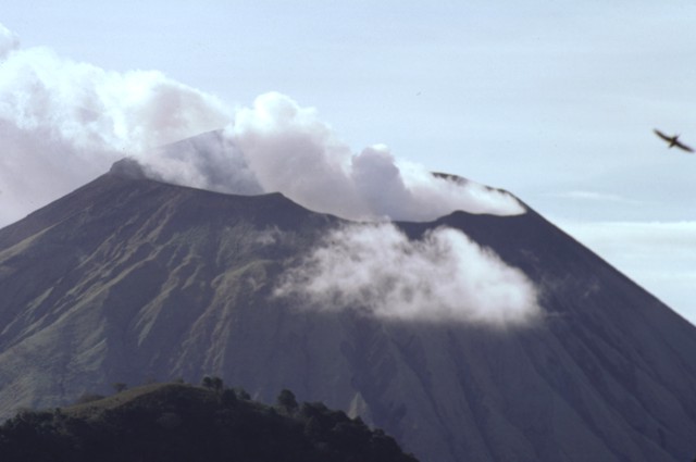
Telica is one of the most active volcanoes in Nicaragua. The volcano consists of several cones and vents. The volcano contains a 700 m wide double crater. The southern crater is the source of recent eruptions. Santa Clara vent erupted in 16th century, but is now covered in vegetation. El Liston is located SE of Telica. Hervideros de San Jacinto is a geothermal area popular with tourists. 2007 Ash emissions Ash emissions to an altitude of 5000 ft occurred at the volcano in January and February 2007.1999-2000 Eruptions An eruptive phase began at Telica volcano in August 1999. On 10th August 1999 ash fell 20 km WSW of Telica in the city of Chichigalpa. A lava lake (pond?) was observed in the crater on 18th August 1999. Eruptions of gas and ash continued until February 2000 and then began to decline. Telica Volcano Eruptions 2007, 2006, 2004, 1999-2000, 1994, 1987, 1981-82, 1981, 1976-78, 1975-76, 1969-71, 1966, 1965, 1962, 1951, 1948-49, 1946, 1943-44, 1941?, 1940, 1939, 1939, 1937-38, 1934, 1929, 1928, 1927, 1918?, 1907, 1791, 1765, 1743?, 1685, 1613, 1529, 1527? http://www.volcanolive.com/telica.html |
Telica, 05.15.2011 |
Photo and caption by Marc Wisniak - http://travel.nationalgeographic.com/travel/traveler-magazine/photo-contest/2012/entries/128926/view/ |
Telica |
Telica |
Telica stratovolcano, one of the most active volcanoes in Nicaragua. The volcano consists of several cones and vents. The volcano contains a 700 m wide double crater. The southern crater is the source of recent eruptions. Santa Clara vent erupted in 16th century, but is now covered in vegetation. El Liston is located SE of Telica. Hervideros de San Jacinto is a geothermal area popular with tourists. 2007 Ash emissions Ash emissions to an altitude of 5000 ft occurred at the volcano in January and February 2007.1999-2000 Eruptions An eruptive phase began at Telica volcano in August 1999. On 10th August 1999 ash fell 20 km WSW of Telica in the city of Chichigalpa. A lava lake (pond?) was observed in the crater on 18th August 1999. Eruptions of gas and ash continued until February 2000 and then began to decline.Telica Volcano Eruptions 2007, 2006, 2004, 1999-2000, 1994, 1987, 1981-82, 1981, 1976-78, 1975-76, 1969-71, 1966, 1965, 1962, 1951, 1948-49, 1946, 1943-44, 1941?, 1940, 1939, 1939, 1937-38, 1934, 1929, 1928, 1927, 1918?, 1907, 1791, 1765, 1743?, 1685, 1613, 1529, 1527? http://www.volcanolive.com/nicaragua.html photo - http://www.sciencephoto.com/media/167934/enlarge |
|
|
Telica is a stratovolcano, one of several volcanoes of the Nicaraguan volcanic front, located in the western part of Nicaragua. Telica has six cones, the tallest of which is 1061 meters high. There is a double crater at the top, 700 meters wide and 120 meters deep. Telica has erupted frequently since the Spanish Era. The most recent eruption was in 2008.In terms of explosive force, Telica''s largest eruption has been rated with a VEI of 4. That eruption occurred in 1529.One of Nicaragua''s most active volcanoes, Telica has erupted frequently, and ash from those frequent eruptions keeps the slopes of its cone bare of vegetation -http://en.wikipedia.org/wiki/Telica_(volcano) |
Telica Photos - http://geographic.org/photos/volcanoes/volcano_photos_72.html |
|
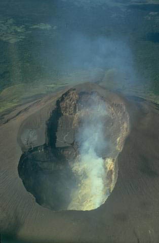
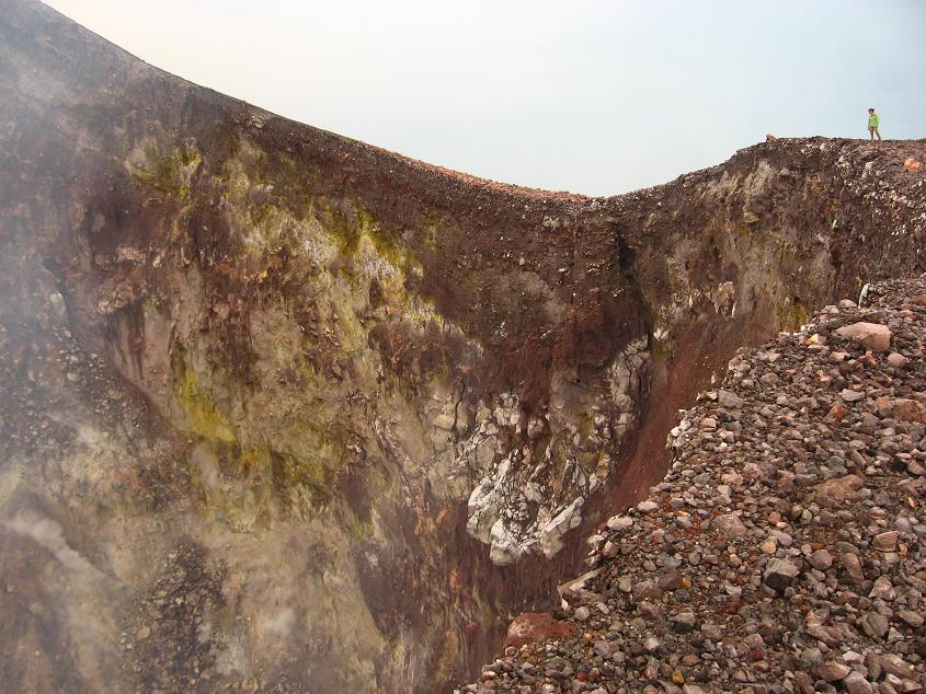
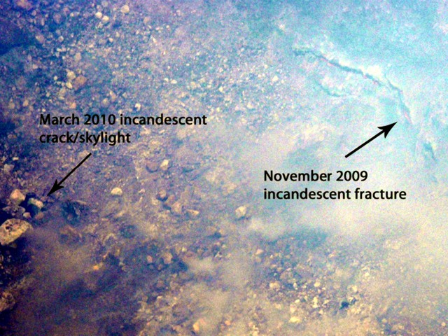
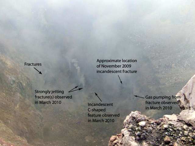
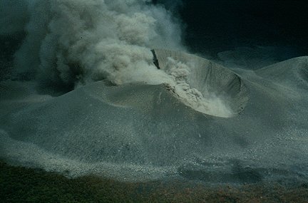
Photograph taken 25 November 2009 of Telica volcano showing the relative locations of the 25 November 2009 incandescent fracture (right) and the later 15 March 2010 incandescent crack/skylight (left). Courtesy of Mel Rodgers.Telica exhibited extensive degassing and sporadic ash explosions during 2006-2008 (BGVN 34:08). Activity since then had decreased to a relatively low level, but degassing was continuing. This report discusses activity in 2009 and January-February 2010 based on reports from the Instituto Nicaragьense de Estudios Territoriales (INETER) and from fieldwork by Mel Rodgers (University of South Florida) in November 2009 and March 2010.INETER publishes a monthly bulletin on earthquakes and volcanic activity in Nicaragua. For Telica, most of the monthly data consists of in-field temperature measurements. An observation camera situated 20 km from the crater has not been functional for more than a year. The seismic instrument at Telica was frequently out of order during 2009.On 20 May 2009, the sulfur dioxide output in the crater ranged from 106-251 tons per day. The maximum temperature of the crater was about 90-112�C in April and May 2009, but rose to 201�C in July, 251�C in August, and 302-317�C during September through November 2009. The maximum temperature of four fumaroles was also measured, which generally ranged from 67-72�C. These temperatures decreased in June 2009 and increased in August 2009 (to 76-105�C). The temperature of fumarole 4 decreased to 59�C in October; gas emission at that fumarole ceased altogether in November.Visits in November 2009 and March 2010. Mel Rodgers detailed observations during fieldwork at the volcano in November 2009 and March 2010 conducted with Diana Roman (University of South Florida), Peter La Femina and Halldor Geirsson (Pennsylvania State University), and Alain Morales (INETER). On 24-25 November 2009, the group observed a set of elongated fractures flanking the crater floor through which incandescence and/or lava were clearly visible. A high concentration of gas and a steady gas-and-vapor plume were also observed in the crater. Multiple vigorous fumaroles were observed on the W side of the crater close to the top of the crater wall, and an intermittent jetting noise that appeared to be coming from the crater floor was audible from their position at the crater rim. A broadband seismometer was installed and, during the 24-hour visit, a high rate of long-period (LP) seismicity was recorded. Telica; summit elev. 1,061 m. All times are local (= UTC - 6 hours) http://www.volcano.si.edu/reports/bulletin/contents.cfm?issue=3503&display=complete |
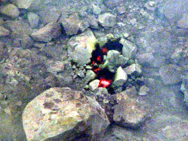
Photograph taken 15 March 2010 showing incandescence visible in the C-shaped crack/skylight at Telica volcano. Courtesy of Mel Rodgers.On 15 March 2010, the researchers returned and again observed incandescence within the crater. Incandescence was clearly visible through a C-shaped crack or skylight, SE of the 25 November 2009 location (figures 21 and 22). A high concentration of gas and a steady gas-and-vapor plume in the crater continued and vigorous degassing of the fumaroles on the crater floor was observed (figure 23). Intermittent jetting noises and rockfalls were audible coming from the crater, and at 2202 UTC a loud, low popping noise from the crater was heard. Data retrieved from the single station installed in November 2009 showed a high rate of LP seismicity from November 2009-March 2010.A successful installation of the TESAND (Telica Seismic and Deformation) network was completed in March 2010. This network, consisting of six broadband seismometers and eight high-rate (1 Hz) continuous global positioning system stations, will be deployed for 3 years to document background LP seismicity and magmatic processes associated with quiescent volcanism.According to the Hawai''i Institute of Geophysics and Planetology (HIGP) Thermal Alerts System, no satellite thermal alerts were measured over Telica during 2008, 2009, and through 30 April 2010. Telica; summit elev. 1,061 m. All times are local (= UTC - 6 hours) http://www.volcano.si.edu/reports/bulletin/contents.cfm?issue=3503&display=complete |
taken 15 March 2010 showing a view of the entire Telica crater floor. Locations of sightings of incandescence and of vigorous gas jets are indicated. Mel Rodgers. Geologic Summary. Telica, one of Nicaragua''s most active volcanoes, has erupted frequently since the beginning of the Spanish era. The Telica volcano group consists of several interlocking cones and vents with a general NW alignment. Sixteenth-century eruptions were reported at symmetrical Santa Clara volcano at the SW end of the Telica group. However, its eroded and breached crater has been covered by forests throughout historical time, and these eruptions may have originated from Telica, whose upper slopes in contrast are unvegetated. The steep-sided cone of 1,061-m-high Telica is truncated by a 700-m-wide double crater; the southern crater, the source of recent eruptions, is 120 m deep. El Liston, immediately SE of Telica, has several nested craters. The fumaroles and boiling mudpots of Hervideros de San Jacinto, SE of Telica, form a prominent geothermal area frequented by tourists, and geothermal exploration has occurred nearby. http://www.volcano.si.edu/reports/bulletin/contents.cfm?issue=3503&display=complete |
Inactive crater of Telica Volcano |
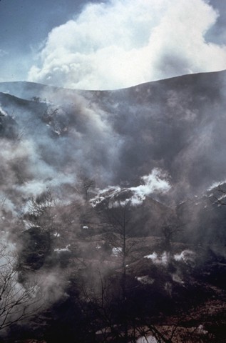
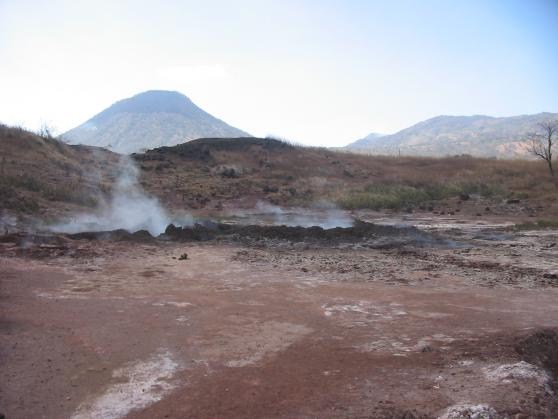
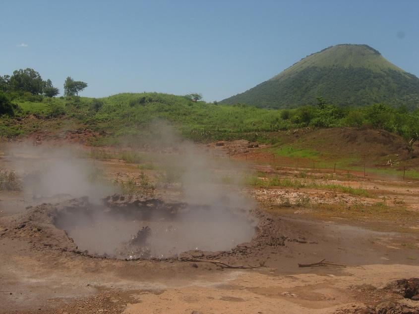
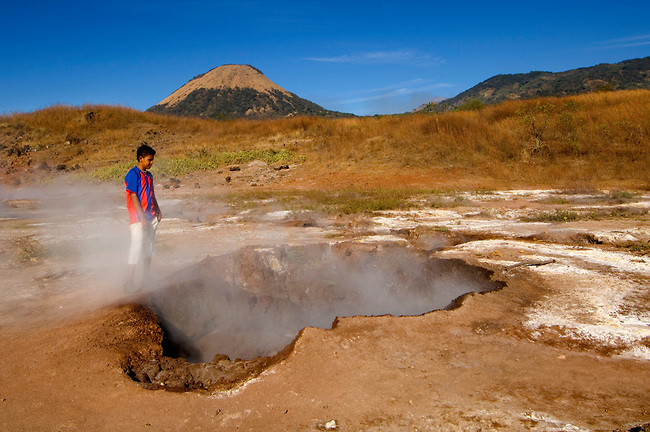
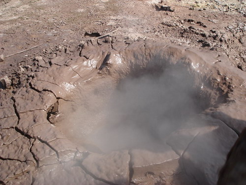
The San Jacinto hot springs in the foothills of Volcan Telica |
San Jacinto |
Boiling Mud Holes Of San Jacinto, Nicaragua |
Telica: dozens of boiling mud |
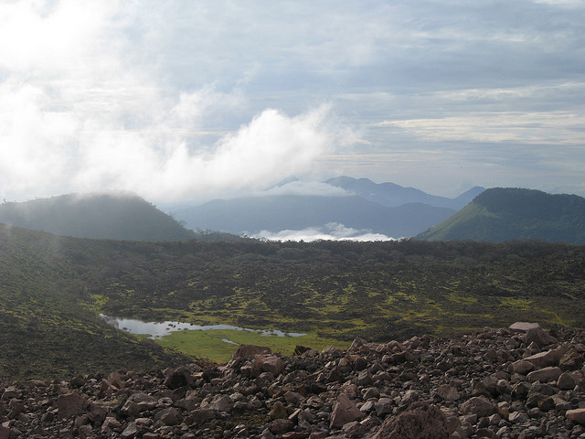
Esteli volcatic field, 899 n, last eruption unknown., Holocene, 13o17''N, 86o40''W. Fresh-looking, sparsely vegetated lava flows mostly erupted from fissure vents are located in valleys in the northern interior highlands between the town of Estelн and the border with Honduras. McBirney and Williams (1965) considered basaltic flows in this area to be certainly of Quaternary, and possibly of Holocene age. The lava flows near Estelн were faulted and slightly tilted during formation of the Estelн structural basin. Other youthful basaltic lava flows, one of which was erupted from the Bonete de Carrao cone, are located between Estelн and Jinotega. Well-preserved cones are also located in the area west and south of Ocotal. Some of the youthful lava flows in northern Nicaragua contain granitic xenoliths and xenocrysts of quartz. The area NW of the town of Esteli (bottom-center) and east of the prominent fault-bound valley at the left contains sparsely vegetated lava flows of the Esteli volcanic field. The flows were mostly erupted from fissure vents located in valleys in the northern interior highlands of Nicaragua between the town of Esteli and the border with Honduras. NASA Landsat7 image (worldwind.arc.nasa.gov) Esteli volcano is located 36 km from the border with Honduras. It consists of fissure vents and associated lava flows. The volcano is located 70 km NE of the main volcanic arc in Nicaragua.Bonete de Carrao cone, located between Estelн and Jinotega erupted a young looking lava flow.http://www.volcanolive.com/nicaragua.html |
Esteli VF. Esteli volcano is a group of young fissure vents, cones and lava flows located 36 km south of Honduras in the northern interior highlands between the town of Estelн and the border. The volcanic center is not on the main volcanic front of Nicaragua, but 70 km NE of the main volcanic arc. Some of the lava flows and cones near Esteli town could be less than 10,000 years old. Fresh-looking, sparsely vegetated lava flows of the Esteli group could be of Holocene age. The lava flows near Estelн were faulted and slightly tilted during formation of the Estelн structural basin. Other youthful basaltic lava flows, one of which was erupted from the Bonete de Carrao cone, are located between Estelн and Jinotega. Well-preserved cones are also located in the area west and south of Ocotal. Some of the youthful lava flows in northern Nicaragua contain granitic xenoliths and xenocrysts of quartz. (from: Smithsonian / GVP information) |
Esteli |
Cerro el Ciguatepe |
Cerro el Ciguatepe Holocene stratovolcano is located in the Nicaraguan interior highlands, east of the Nicaraguan depression and one of several Quarternary volcanoes in this area. It contains a well-reserved 1.5 km wide summit crater, which contains a blocky lava dome and a young lava flow that has traveled from a breach in the SW side of the crater to the base of the cone. The steep-sided stratovolcano was constructed east of the Rio Pacora, NE of Lake Managua at the boundary of the flat-lying Tertiary ignimbrite deposits with the fault-blocks bordering the Nicaraguan depression. 12.53 N, 86.142W , summit elevation 603 m . Cerro el Ciguatepe is located in the Nicaraguan interior highlands. The volcano contains a 1.5 km wide crater, lava dome and lava flows. http://www.volcanolive.com/ciguatepe.html The small circular volcano at the center of this NASA Landsat image east (right) of the Rio Pacora (left of center) is Cerro el Ciguatepe. This volcano lies in the Nicaraguan interior highlands, east of yellow-colored Lake Managua (lower left). A prominent breach can be seen in the SW wall of the well-preserved 1.5-km-wide crater. A small lava flow extends a short distance beyond the base of the cone through the breach, and a blocky plug dome was emplaced in the center of the crater. The dark-colored lake at the upper right is Laguna Moyua. Cerro el Ciguatepe is one of several Quaternary volcanoes that lie in the Nicaraguan interior highlands, east of the Nicaraguan depression. The steep-sided stratovolcano was constructed east of the Rнo Pacora, NE of Lake Managua at the boundary of the flat-lying Tertiary ignimbrite deposits with the fault-blocks bordering the Nicaraguan depression. A small lava flow extends a short distance beyond the base of the cone through a breach in the SW wall of the well-preserved 1.5-km-wide crater. A blocky plug dome occupies the center of the crater. The relatively well-preserved Cerro el Ciguatepe cone is morphologically similar to the youthful cones of the Nejapa alignment (van Wyk de Vries 1999, pers. comm.) and may be of Holocene age. |
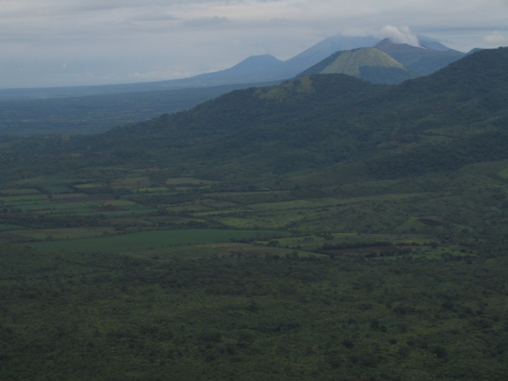
View to the Northwest. From the back: El Chonco, San Cristobal, Telica (smoking), Rota. |
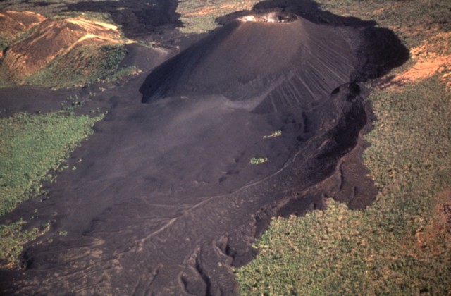
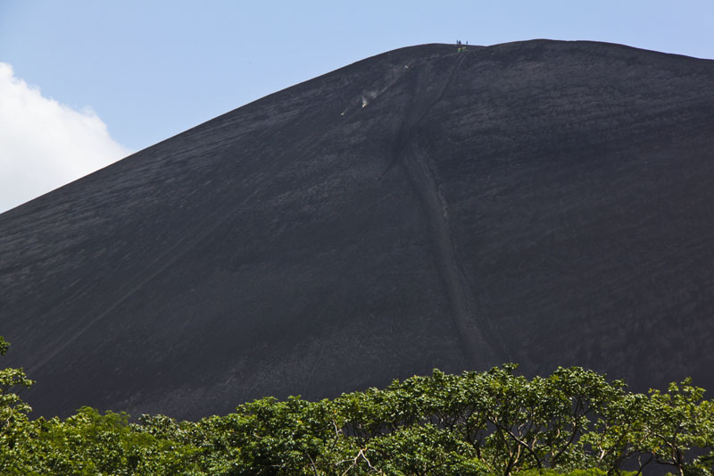
Cerro Negro. Cerro Negro, summit elevation 675 m, cinder cones was born in 1850 and is the youngest volcano in central America. The volcano is composed of black scoriae and aa lava flows which have reached 4 km on NE. Eruption of Cerro Negro in August 1999 included ash emission and lava fountain.Cerro Negro Volcano Eruptions 1999, 1995, 1992, 1971, 1969, 1968, 1964, 1963, 1962, 1961, 1957, 1954, 1950-51, 1949, 1948, 1947, 1929, 1923, 1919, 1914, 1899, 1867, 1850 - http://www.volcanolive.com/nicaragua.html Photograph: Anita Baca/AP - http://www.guardian.co.uk/travel/2007/apr/15/escape.skiing.climbingholidays |
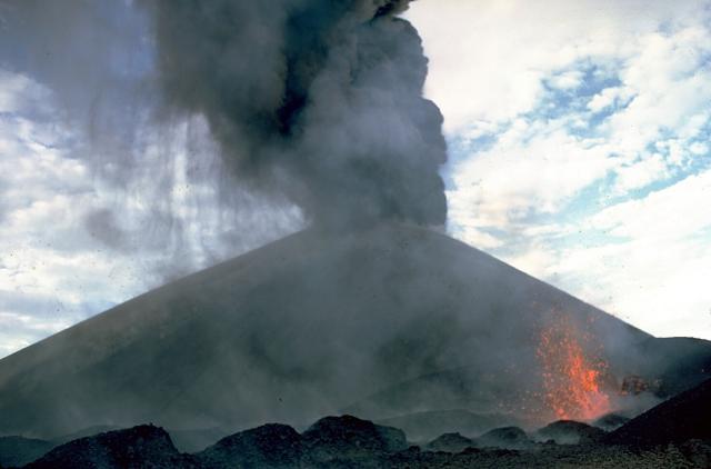
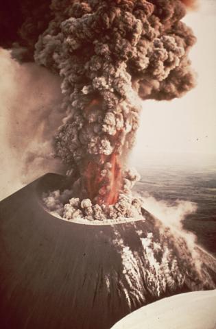
An ash plume rises above Cerro Negro on July 24, 1947. A strong explosive eruption beginning on July 9 produced ashfall that damaged crops at Malpaisillo and prompted evacuations of towns west of the volcano. Ash fell to the Pacific coast and to 7 inches on the roof of the cathedral at Leon. A NE-flank parasitic cone was formed and lava flows were emitted from both summit and flank vents. The eruption lasted until August 2, 1947.Photo by Ray Wilcox, 1947 (U.S. Geological Survey).http://www.volcano.si.edu/world/volcano.cfm?vnum=1404-07=&volpage=photos |
Eruption of Cerro Negro in 1948. Another 18 years passed before Cerro Negro erupted again, but on July 9, 1947 the volcano had its largest eruption to date. The VEI was recorded at 3 along the summit and NE flank, with the eruptive characteristics including central vent eruption, flank venting, and lava flows. Evacuations were called for the Malpaisillo village, and major land and property damage resulted from the volcano�s explosive eruptions. The recorded lava volume was 3.8 x 10 step6 m3 and the recorded tephra volume was 3.1 x 10step7 m3.Less than one year later, on March 31, 1948, Cerro Negro recorded another Strombolian eruption (VEI 2) from its central vent. No lava or tephra volumes were recorded, however. A similar eruption occurred in June 1949, with the VEI 2 eruption exploding from the central vent.Another sub-plinian VEI 3 explosive vulcanian eruption occurred from Cerro Negro�s central vent from November 21 to December 17, 1950. Lava flows resulted, but evacuation was unnecessary. The lava volume was 1.0 x 10 step5 m3 and the tephra volume was 3.8 x 10 step7 m3 for this particular eruption.In February 1954 another VEI 2 Strombolian eruption exploded out of Cerro Negro�s central vent, but lava and tephra volumes were not recorded. Three years later from September 4�24, 1957, a VEI of 2 was recorded via the summit and east flank of Cerro Negro. Lava flows damaged the land from the explosive eruption, with the lava volume reaching 4.5 x 10 step6 m3 and the tephra volume reaching 2.8 x 10 step6 m3. The summit and south flank exploded next on September 28, 1960, and volcanic activity continued until December 26. This particular VEI was determined to be level 3 after radial fissure and central vent eruptions occurred. Land damage was caused to the surrounding land via lava flows, with the volume of the lava recorded at 5.2 x 10 step6 m3 and the tephra volume recorded at 3.4 x 10 step7 m3.Cerro Negro�s NE-flank fissure erupted next on October 25, 1961. Although radial fissure eruption and lava flow was characteristic of this particular eruption, the VEI was only recorded as a 1, and no lava or tephra volumes were recorded. It was the smallest Cerro Negro eruption to date.Another eruption from the central vent occurred on March 21, 1962 and lasted until early April. The VEI was recorded as 2, and lava flows were observed, although no land damage was witnessed. Exactly one year later, a VEI 1 eruption occurred from the central vent of Cerro Negro on March 21, 1963. http://en.wikipedia.org/wiki/Cerro_Negro |
Eruption of Cerro Negro in 1968. The volcanic activity from October 23 until December 10, 1968 marked the formation of the Cristo Rey crater, when the summit and south flank of Cerro Negro erupted with a sub-plinian VEI of 3. The new vent formed a lava flow 750m long and 600m wide and a thickness of 3m. Thirteen villages located near the erupting volcano were evacuated on the 27th because of the excessive ash falls. Additional larger-scale evacuations Nicaragua�s 2nd largest city, Leуn, recorded ash falls of over 1 cm thick. Lava flows advanced at a rate of 23 m/day, and it caused additional land damage as the lava poured from three of Cerro Negro�s craters, fountaining to heights of 30m into the air. The eruptive ash columns reached heights of from 2.3 to 4.8 km. In addition, incandescent gases from the vents raised to heights of 120 meters, and these could be seen over 50 km away from the volcano. When the volcanic activity ceased, the lava volume totaled 6.9 x 10 step6 m3 and the tephra volume totaled 2.7 x10 step7 m3. Another small-scale VEI 1 eruption took place after the central vent exploded from December 19�29, 1969. But two years later from February 3�14, 1971, the towns surrounding Cerro Negro were again evacuated due to the sudden sub-plinian VEI 3 eruption of the summit and the formation and eruption of a new eastern flank. Volcanic bombs were shot approximately 600m into the air, and incandescent gases were released during the time in between eruptions. Ash columns were approximately 10 km high, and a tephra volume of 5.8 x10 step7 m3 (over 300 km2) caused major damage to the local crops and buildings. The city of Leуn alone had recorded 18 cm of ash, which resulted in large-scale building collapse.Over 20 years passed, and the Cerro Negro volcano was at peace until one of the volcano�s largest eruptions occurred on April 9, 1992. Volcanic activity lasted for a total of five days, with the main sub-plinian eruption (VEI 3) occurring over a two-day time period, producing an ash column that was roughly seven kilometers high. Over 20,000 people were immediately evacuated, mostly due to failed water systems until eruptions ceased on the 14th of April. This eruption caused several fatalities, and widespread damage to land and property after the tephra volume measured 2.6 x 10 step7 m3. This large tephra volume produced approximately four centimeters of ash across most of Leуn, resulting in many collapsed roofs and additional injuries and fatalities.Three years later, volcanic activity started on May 29, 1995, which marked the beginning of the first phase of this eruption. Small, phreatic eruptions occurred frequently during this phase, averaging 100-160 explosions per day. These Strombolian eruptions generated convective ash columns that reached heights of 200�1000 meters, and these explosions lasted for a period of 79 days. A low-energy pyroclastic flow was observed on the northwestern flank on June 2. After June 6, the number of eruptions decreased gradually at a rate of 30-40 eruptions per day. By July 19, all volcanic activity ceased for a period of 95 days. By mid-November, the hiatus ended and the second phase commenced. Eruptions continued for a period of thirteen days and lasted until December 3, 1995. During this time, the eruptions were larger, and volcanic bombs and blocks up to two meters in diameter were ejected from Cerro Negro. Ash columns achieve heights of 2 to 2.5 meters While the VEI was only measured as a 2, central vent explosions, pyroclastic flows, phreatic explosions, and lava dome extrusion were all characteristic of this eruption period. New lava filled about 2/3 of the 1992 crater, and additional lava flows caused damage to land, extending 1.5 km north of the north base cone. Ash falls caused damage to property and farmland, with an average deposit of two millimeters per day in Leon (20 km from volcano), but there were no fatalities during the safe evacuation of 6000 people in the surrounding villages. Overall, the lava flow volume reached 8.0 x 10 step6 m3 and the tephra volume peaked at 5.8 x 10 step6 m3 during this eruption period, resulting in the addition of about 50 meters of height to the cinder cone. The last volcanic activity at Cerro Negro occurred on August 5, 1999 and lasted for a total of two days. Three earthquakes (Mw 5.2) occurred in three hours, which triggered a small-scale eruption of the volcano. It was the first time in the history of Cerro Negro that large-magnitude earthquakes preceded the eruption. The VEI was only recorded as a 1, as the south flank (near the Cristo Rey crater) experienced radial fissure eruption, along with explosive and phreatic eruptions, in the formation of three new vents. Small-scale evacuations of surrounding villages were carried out, but the low-volatile, highly crystalline basaltic magama only had a lava volume of 6 x 10 step5 m3. Additionally, the tephra volume was only in the 106m3 range. It was concluded that the volcanic activity of Cerro Negro in 1999 was tectonically-induced, and had three earthquakes not occurred, the eruption would have also not occurred.The most recent eruptions at Cerro Negro occurred in August 1999, although strong seismic activity was registered in early 2004. -http://en.wikipedia.org/wiki/File:Cerro_Negro_eruption_1968.jpg |
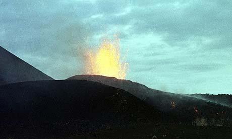
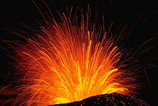
A time exposure captures a nighttime view of a strombolian explosion in November 1968 from Cerro Negro volcano in Nicaragua. The trajectory of individual incandescent volcanic bombs can be seen radiating from the vent. Still-hot bombs continue to glow after landing on the outer flanks of the cinder cone. The 1968 eruption was one of many from Cerro Negro, Central America''s youngest volcano.Photo by Robert Citron, 1968 (Smithsonian Institution).http://www.volcano.si.edu/world/volcano.cfm?vnum=1404-07=&volpage=photos |
Vigorous strombolian eruptions from Nicaragua''s Cerro Negro volcano in 1968 produce an ash-rich column above the vent. Strong incandescent lava fountaining can be seen at the base of the column. Steam rises from fumaroles on the righthand side of the cinder cone. Ash and cinders fall from the eruption column at the left.Photo by William Melson, 1968 (Smithsonian Institution). http://www.volcano.si.edu/world/volcano.cfm?vnum=1404-07=&volpage=photos |
Winds deflect an ash column originating from the summit crater of Cerro Negro in 1968. At the same time a vent on the lower south flank, which is emitting a thin, lighter-colored steam column in this view, fed a lava flow. The advancing flow forms the black lobe extending to the lower left corner of the photo. The 1968 eruption began on October 23 and continued until December 15.Photo by William Melson, 1968 (Smithsonian Institution).http://www.volcano.si.edu/world/volcano.cfm?vnum=1404-07=&volpage=photos |
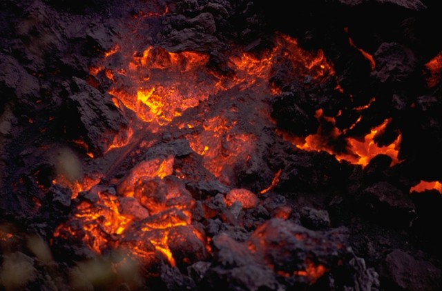
Incandescent lava is visible on the cooling surface of an advancing lava flow from Cerro Negro volcano in 1968. The flow front, which advanced at a rate of about 5 m/hr during the first day of the eruption. The flow originated from a horseshoe-shaped flank vent south of Cerro Negro.Photo by William Melson, 1968 (Smithsonian Institution).http://www.volcano.si.edu/world/volcano.cfm?vnum=1404-07=&volpage=photos |
Fumaroles near the flank vent at Cerro Negro in November 1968. Incandescent spatter is ejected from the vent in the background behind volcanologist Dick Stoiber (left), who led many expeditions from Dartmouth College to Central American volcanoes. This fumarole was a source of tenorite (CuO) and other minerals.Copyrighted photo courtesy of Dick Stoiber, 1968 (Dartmouth College).http://www.volcano.si.edu/world/volcano.cfm?vnum=1404-07=&volpage=photos |
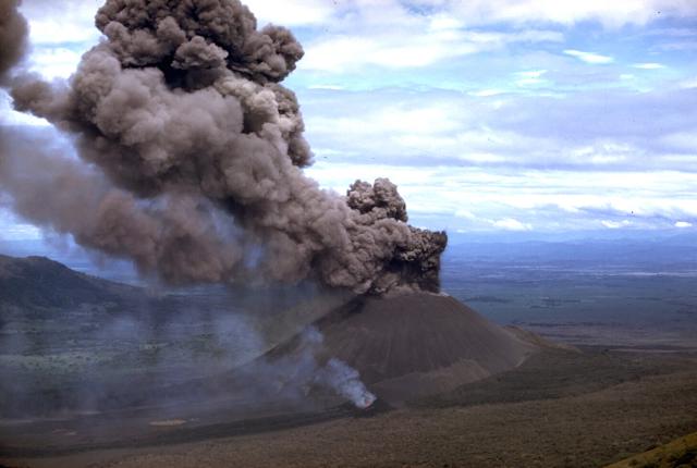
A large tephra cloud silhouetted against weather clouds rises from Cerro Negro volcano in November 1968. Strong winds blowing from the east deflect the ash plume. This view from the SW looks across cotton fields of the Nicaraguan central depression to the Marrabios Range volcanoes. To the right of Cerro Negro is Las Pilas volcano, and the broad massif to the left is Rota volcano.Photo courtesy of Dick Stoiber, 1968 (Dartmouth College).Ash falls at the left from a strombolian eruption column emanating from the summit crater of Cerro Negro volcano in 1968. At the same time incandescent spatter (lower right) is ejected from a small vent on the south flank of the cone. The 1968 eruption began on October 23 and lasted until December 15. The south-flank vent also fed a lava flow that traveled 1.5 km.http://www.volcano.si.edu/world/volcano.cfm?vnum=1404-07=&volpage=photos |
Lava flows from the 1995 eruption of Cerro Negro traveled to the NNE, overtopping earlier flows from eruptions in 1923, 1947, and 1957. The 1995 flows traveled a maximum distance of more than 2 km from a new vent within the 1992 summit crater. The flows mostly were emplaced between November 22 and December 2. They covered an area of 0.65 sq km, and individual flow lobes had thicknesses of 2 to 10 meters. Photo by Britt Hill, 1995 (Southwest Research Institutehttp://www.volcano.si.edu/world/volcano.cfm?vnum=1404-07=&volpage=photos |
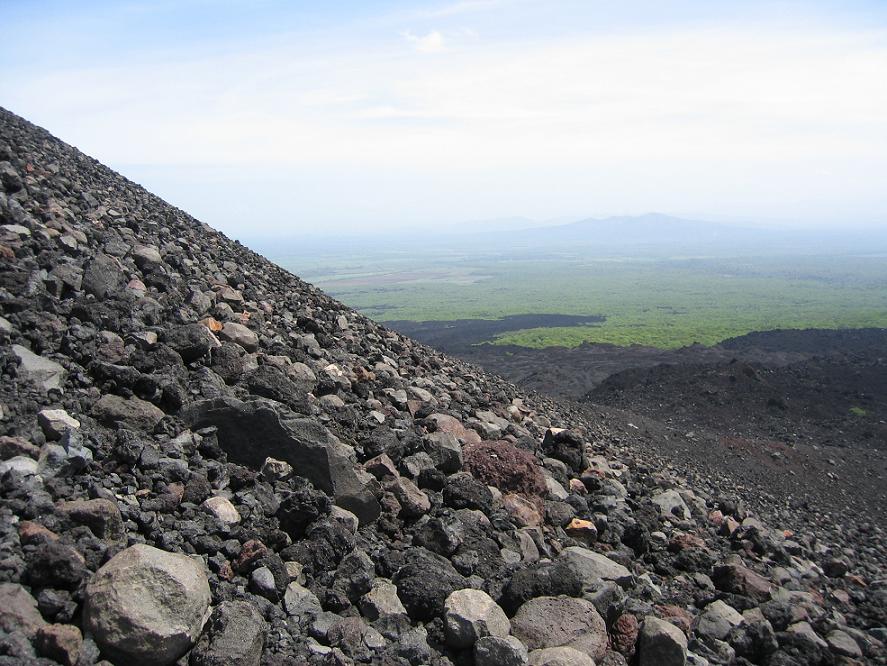
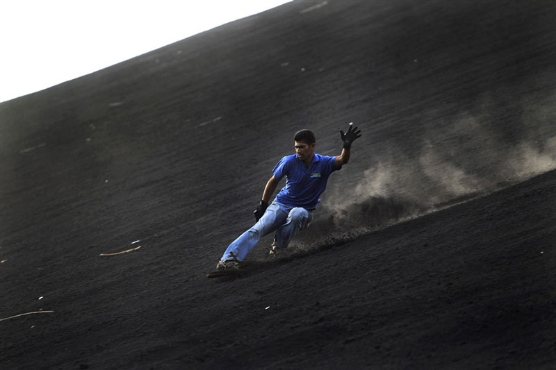
Cerro Negro is the volcano that is black and covered in volcanic rock. It erupts fairly frequently and creates new landslides. It apparently had a tight schedule of erupting once every 10 years, however our guide told us the volcano was going on 20 years without any eruptions |
More than 20 eruptions, separated by quiet intervals of a few years to a few decades, have taken place in the past century and a half at this small-volume basaltic volcano. Photo by Jaime Incer, 1980. http://www.volcano.si.edu/world/volcano.cfm?vnum=1404-07=&volpage=photos |
This isn''t the side you run down. The volcanic activity from October 23 until December 10, 1968 marked the formation of the Cristo Rey crater, when the summit and south flank of Cerro Negro erupted with a sub-plinian VEI of 3. The new vent formed a lava flow 750m long and 600m wide and a thickness of 3m. Thirteen villages located near the erupting volcano were evacuated on the 27th because of the excessive ash falls. Additional larger-scale evacuations Nicaragua�s 2nd largest city, Le�n, recorded ash falls of over 1 cm thick. Lava flows advanced at a rate of 23 m/day, and it caused additional land damage as the lava poured from three of Cerro Negro�s craters, fountaining to heights of 30m into the air. The eruptive ash columns reached heights of from 2.3 to 4.8 km. In addition, incandescent gases from the vents raised to heights of 120 meters, and these could be seen over 50 km away from the volcano. When the volcanic activity ceased, the lava volume totaled 6.9 x 10 step6 m3 and the tephra volume totaled 2.7 x10 step7 m3. Another small-scale VEI 1 eruption took place after the central vent exploded from December 19�29, 1969. But two years later from February 3�14, 1971, the towns surrounding Cerro Negro were again evacuated due to the sudden sub-plinian VEI 3 eruption of the summit and the formation and eruption of a new eastern flank. Volcanic bombs were shot approximately 600m into the air, and incandescent gases were released during the time in between eruptions. Ash columns were approximately 10 km high, and a tephra volume of 5.8 x10 step7 m3 (over 300 km2) caused major damage to the local crops and buildings. The city of Le�n alone had recorded 18 cm of ash, which resulted in large-scale building collapse.Over 20 years passed, and the Cerro Negro volcano was at peace until one of the volcano�s largest eruptions occurred on April 9, 1992. Volcanic activity lasted for a total of five days, with the main sub-plinian eruption (VEI 3) occurring over a two-day time period, producing an ash column that was roughly seven kilometers high. Over 20,000 people were immediately evacuated, mostly due to failed water systems until eruptions ceased on the 14th of April. This eruption caused several fatalities, and widespread damage to land and property after the tephra volume measured 2.6 x 10 step7 m3. This large tephra volume produced approximately four centimeters of ash across most of Le�n, resulting in many collapsed roofs and additional injuries and fatalities.Three years later, volcanic activity started on May 29, 1995, which marked the beginning of the first phase of this eruption. Small, phreatic eruptions occurred frequently during this phase, averaging 100-160 explosions per day. These Strombolian eruptions generated convective ash columns that reached heights of 200�1000 meters, and these explosions lasted for a period of 79 days. A low-energy pyroclastic flow was observed on the northwestern flank on June 2. After June 6, the number of eruptions decreased gradually at a rate of 30-40 eruptions per day. By July 19, all volcanic activity ceased for a period of 95 days. By mid-November, the hiatus ended and the second phase commenced. Eruptions continued for a period of thirteen days and lasted until December 3, 1995. During this time, the eruptions were larger, and volcanic bombs and blocks up to two meters in diameter were ejected from Cerro Negro. Ash columns achieve heights of 2 to 2.5 meters While the VEI was only measured as a 2, central vent explosions, pyroclastic flows, phreatic explosions, and lava dome extrusion were all characteristic of this eruption period. New lava filled about 2/3 of the 1992 crater, and additional lava flows caused damage to land, extending 1.5 km north of the north base cone. Ash falls caused damage to property and farmland, with an average deposit of two millimeters per day in Leon (20 km from volcano), but there were no fatalities during the safe evacuation of 6000 people in the surrounding villages. Overall, the lava flow volume reached 8.0 x 10 step6 m3 and the tephra volume peaked at 5.8 x 10 step6 m3 during this eruption period, resulting in the addition of about 50 meters of height to the cinder cone. The last volcanic activity at Cerro Negro occurred on August 5, 1999 and lasted for a total of two days. Three earthquakes (Mw 5.2) occurred in three hours, which triggered a small-scale eruption of the volcano. It was the first time in the history of Cerro Negro that large-magnitude earthquakes preceded the eruption. The VEI was only recorded as a 1, as the south flank (near the Cristo Rey crater) experienced radial fissure eruption, along with explosive and phreatic eruptions, in the formation of three new vents. Small-scale evacuations of surrounding villages were carried out, but the low-volatile, highly crystalline basaltic magama only had a lava volume of 6 x 10 step5 m3. Additionally, the tephra volume was only in the 106m3 range. It was concluded that the volcanic activity of Cerro Negro in 1999 was tectonically-induced, and had three earthquakes not occurred, the eruption would have also not occurred.The most recent eruptions at Cerro Negro occurred in August 1999, although strong seismic activity was registered in early 2004. In 1998, an eruption was thought to have occurred shortly after the passage of Hurricane Mitch, but it later transpired that the copious amounts of steam seen rising from the volcano were caused by rainwater percolating through to hot lava from the 1995 eruption.Following the 1999 eruption, the summit crater and fissures created from this eruption are currently the main source of volcanic gas flux today. It is estimated that the total CO2 output of Cerro Negro is conservatively estimated to be 2,800 t d-1.Although the Cerro Negro volcano has only been around for a period of 159 years, it has erupted at least 23 times, which is highly active compared to most volcanoes. This historical growth of the volcano has allowed for documentation of the growth of this volcano overtime. It was discovered that the timing of future eruptions is correlated with the volume of the previous significant eruption. Since there have been steady-state eruptions since 1900, a Cerro Negro Time-Volume Prediction Model was made.Although a small-scale eruption did occur in A.D. 1999, another larger-scale eruption is expected to occur in the immediate future. Cerro Negro does not differ from most volcanoes, in that numerous hazards are associated with volcanic activity. These hazards include lava flows, mudslides, pyroclastic flows, and earthquakes, but the biggest hazard of Cerro Negro is the effects of the ash and tephra fallouts.Currently, Cerro Negro is being monitored by the Nicaraguan Seismic Network, which is affiliated with INETER (Instituto Nicaraguense de Esdudios Territoriales). These programs have a total of 36 stations throughout Nicaragua, and they each have a monitoring station on Cerro Negro. Seismic activity, gas concentrations, surface deformation, and temperature fluctuations are all carefully watched in order to mitigate the effects of a possible eruption.It is extremely fortunate that Cerro Negro lies in a less-populated area of Nicaragua, and because of this, there is little volcanic risk compared to many of the other volcanoes in the world. Since there are few people that live near the actual volcano, fatalities are not high when there is an eruption, because the lava flows, mudslides, and pyroclastic flows that come from Cerro Negro are not in the direct path of major cities or towns. Nevertheless, the eruptions of Cerro Negro have been known to cause catastrophic damage to buildings and farmland, due to the widespread ash falls and tephra fallouts. Although there has yet to be a catastrophic disaster event at Cerro Negro, it does not mean that one will never occur. Precautions need to be taken every time there is a potential eruption. As long as constant monitoring of Cerro Negro continues, and proper evacuation measures are taken every time there is an eruption, there should be little loss of life. Everything else is out of human control. Only time will tell when the next major eruption of Cerro Negro occurs, and what the effects of the eruption will have on the people of Nicaragua.http://en.wikipedia.org/wiki/Cerro_Negro |
The lava flow at the right, partially mantled by tephra, was erupted in July 1947. A strong explosive eruption produced ashfall that damaged crops at Malpaisillo. The 1947 lava flow originated from a parasitic cone and traveled to the NE. This photo from the northern side of Cerro Negro also shows darker-colored lava flows from the 1957 eruption at the extreme right and at the upper left.Photo by Bill Rose, 1971 (Michigan Technological University).http://www.volcano.si.edu/world/volcano.cfm?vnum=1404-07=&volpage=photos |
An aerial view from the SW after the 1992 eruption shows the greatly enlarged summit crater. The 1992 eruption expanded the summit crater to 370 m in diameter and an average depth of 90 m. Heavy ashfall caused extensive damage to buildings and croplands. No lava flows were erupted. The lobate lava flow extending to the bottom of the photo was erupted in 1968, and the tephra-mantled flow to its left was emplaced in 1960.Photo by Jaime Incer, 1992.http://www.volcano.si.edu/world/volcano.cfm?vnum=1404-07=&volpage=photos |
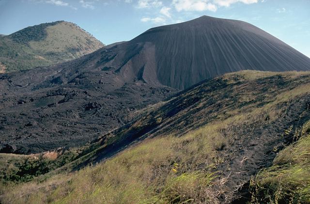
Prominent flow levees are visible on the surface of the 1968 lava flow from Cerro Negro in the foreground, marking individual flow lobes. This flow originated from a spatter cone (named Cristo Rey) on the south flank of Cerro Negro and traveled 1.5 km from the vent. Tephra covers and smooths the surface texture of an older flow in front of the cone to the left; this flow was emplaced during the 1960 eruption. Photo by Jaime Incer, 1980.http://www.volcano.si.edu/world/volcano.cfm?vnum=1404-07=&volpage=photos |
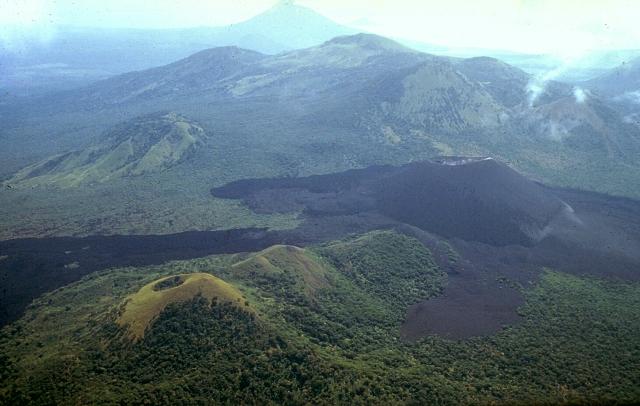
The short dark-colored lava flow in the left foreground and the left-hand, darker flow extending to the lower right-hand margin originated from a vent on the eastern flank of Cerro Negro during a September 4-24, 1957 eruption. In between these flows is an older lighter-colored flow that was erupted in 1947. The long 1957 flow lobe at the lower right overlies a slightly lighter-colored flow to its right that was emplaced in 1923. This view from the NE also shows older vegetated cones including Cerro la Mula, the grassy cone at the extreme right.Photo by Jaime Incer, 1980..http://www.volcano.si.edu/world/volcano.cfm?vnum=1404-07=&volpage=photos |
Both the closer part of the compound lava flow extending to the left margin of the photo beyond the vegetated Cerro la Mula cone at the lower left as well as the lighter-colored lava flow directly in front of Cerro Negro were emplaced during a major eruption in 1923. Cerro Negro erupted for seven weeks beginning October 23, 1923. Intense explosive activity increased the height of the cone to 300 m and left a 60-m-wide crater. The broad massif behind Cerro Negro is the Las Pilas complex, and conical Momotombo stratovolcano is in the background to the SE. |
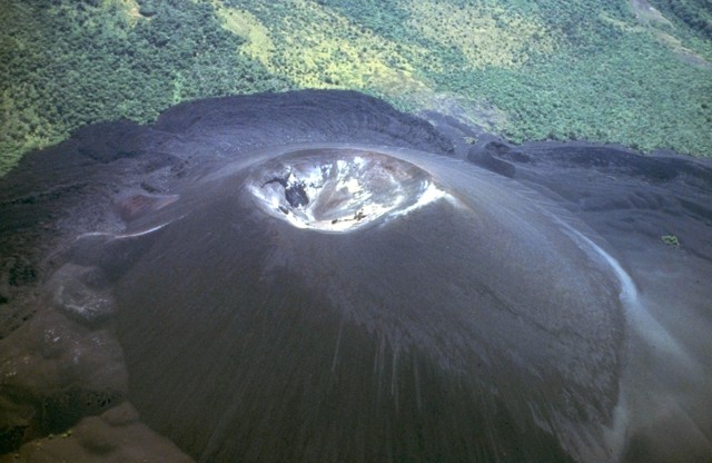
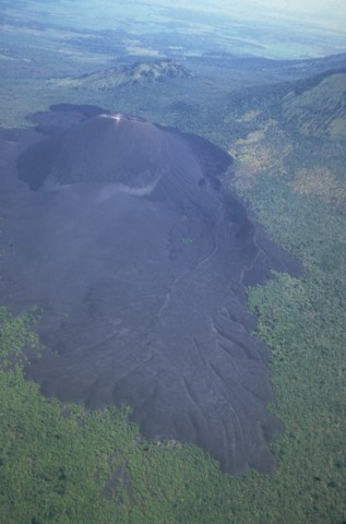
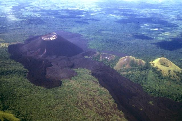
Cerro Negro, the largest and youngest of a group of four cinder cones that were constructed along a N-S line, is Central America''s youngest volcano. Since its formation in 1850, Cerro Negro has produced frequent explosive eruptions, building a 250-m-high cinder cone surrounded by a fresh lava field. This 1995 photo from the southernmost of the older cones to the NNE shows flow levees and lava flows at the left side of Cerro Negro that were produced during the 1995 eruption. The vegetated peak in the background is part of the Las Pilas complex. Central America''s youngest volcano, Cerro Negro, was born in April 1850 and has since been one of the most active volcanoes in Nicaragua. Cerro Negro is the largest, southernmost, and most recent of a group of four youthful cinder cones constructed along a NNW-SSE-trending line in the central Marrabios Range 5 km NW of Las Pilas volcano. Strombolian-to-subplinian eruptions at Cerro Negro at intervals of a few years to several decades have constructed a roughly 250-m-high basaltic cone and an associated lava field that is constrained by topography to extend primarily to the NE and SW. Cone and crater morphology at Cerro Negro have varied significantly during its eruptive history. Although Cerro Negro lies in a relatively unpopulated area, its occasional heavy ashfalls have caused damage to crops and buildings in populated regions of the Nicaraguan depression. http://www.volcano.si.edu/world/volcano.cfm?vnum=1404-07=&volpage=photos |
Cerro Negro is in the Cordillera de los Maribios mountain range in Nicaragua, about 10 km from the village of Malpaisillo. It consists of a gravelly basaltic cinder cone, which contrasts greatly with the surrounding verdant hillsides, and gives rise to its name, which means Black Hill. Cerro Negro has erupted frequently since its first eruption. One unusual aspect of several eruptions has been the emission of ash from the top of the cone, while lava erupts from fractures at the base.Cerro Negro is a polygenetic cinder cone that is part of the Central American Volcanic Arc, which formed as a result of the Cocos plate subducting under the Caribbean plate, at a rate of 9 cm/year. It is the largest and southernmost of four cinder cones that have formed along a NW-SE trend line in the Cordillera de los Maribios mountain range. Despite its youth, Cerro Negro has been one of the most active volcanoes in Nicaragua, with its latest eruption occurring in 1999. Since its birth in 1850, it has erupted approximately 23 times.http://en.wikipedia.org/wiki/Cerro_Negro |
The first eruption of Cerro Negro occurred on April 13, 1850 and volcanic activity lasted until May 27. Central vent and explosive eruptions transpired, with lava flow and damage to land and property. The Volcanic Explosivity Index (VEI) was recorded at 2 out of 8, classifying the eruption as Strombolian/Vulcanian. Finally, the lava volume was recorded to be 5.4 x 10 and the tephra volume was 6.5 x 10step5 m3.Cerro Negro�s second eruption took place on November 14, 1867 and volcanic activity lasted until November 30. Radial fissure and explosive eruptions occurred, with some lava flows, along the NE-SW trend line fissure. The VEI was also recorded at 2 (Strombolian/Vulcanian), and the tephra volume was 8.6 x 10step6 m3.The third eruption of Cerro Negro occurred 32 years later and lasted from November 22 to November 29, 1899. Explosive eruptions resulted in damaged land, and the VEI was also recorded as a 2. Finally, the tephra volume was documented at 1.7 x 10step6 m3.From October 28 to November 3, 1914, the volcano erupted explosively at the central vent. Mudslides also resulted in increased damage to the land, but there were no fatalities because they did not flow over any villages or towns. Although the VEI was yet again 2, the tephra volume was a recorded 2.8 x 10step6 m3.Five years later, Cerro Negro erupted again from June 20�30, 1919, with explosive eruptions resulting in a VEI of 2. No tephra or lava volumes were recorded at this time.Just four years after that, from October 23 until December 11, 1923, Cerro Negro erupted along the summit and upper north flank. Central vent and radial fissure explosions erupted during this time, and lava flows were recorded in this VEI 3 sub-plinian eruption. It was the largest eruption in the history of the volcano, with the lava volume being 1.0 x 10step7 m3 and the tephra volume being 3.6 x 10step7 m3.Cerro Negro erupted next on February 10, 1929, and volcanic activity lasted until March. Flank (excentric) vent and radial fissures also explosively erupted, resulting in excessive lava flows. The volume of lava erupted was recorded at only 1.0 x 10step5 m3 in the VEI 2 eruption. http://en.wikipedia.org/wiki/Cerro_Negro |
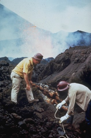
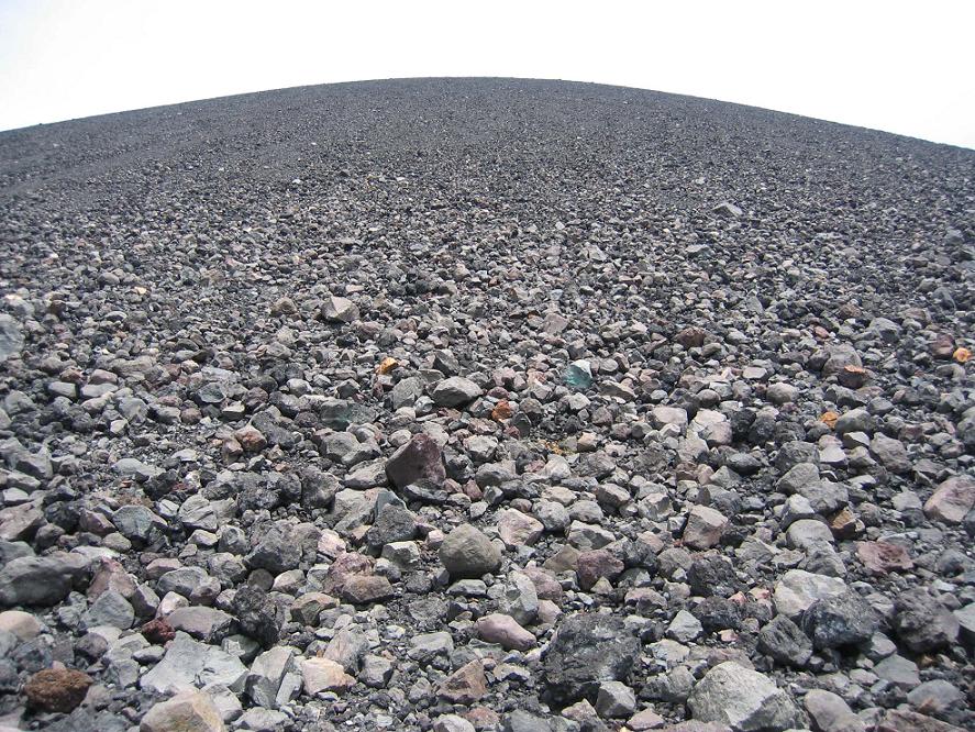
Color photograph (such as it is) from the base to the rim of the outer crater. Decreasing rock size shows perspective |
|
Cerro Negro - effects of the previous eruption during February 3-14, 1971 |
The summit crater of Cerro Negro is seen in March 1967, a year and half prior to the 1968 eruption. Light-colored areas result from heavy sublimate deposition. Frequent historical eruptions have greatly modified the morphology of Cerro Negro''s summit crater. Photo by Bill Rose, 1967 (Michigan Technological University).http://www.volcano.si.edu/world/volcano.cfm?vnum=1404-07=&volpage=photos |
This is either the crater or the pit of Sarlacc. http://en.wikipedia.org/wiki/Sarlacc |
Sulfur deposit, crater, and Las Pilas in the background |
Cerro Negro cinder cone in Nicaragua, Central America''s youngest volcano, was born in April 1850. It has been one of Nicaragua''s most active volcanoes, building up a roughly 250-m-high cinder cone surrounded by a field of fresh lava flows. Cerro Negro is seen here in 1981 from Cerro la Mula on the north, the next in a chain of four cinder cones erupted along a N-S line |
Cerro Negro lava |
Rotation bomb. There''s no scale, but I remember this being about 2 m long |
Aerodynamic volcanic bomb from Cerro Negro, Nicaragua. ~2m long -http://volcanoclast.com/tag/nicaragua/ |
|
|


http://www2.brevard.edu/reynoljh/centralamerica/nicaragua.htm Masaya, Cerro Negro, Momotombo
Azul, 12.53 N, 83.87, Wsummit elevation 201 m , cinder cones is located on the Atlantic coastal plain of Nicaragua. The volcano contains three cinder cones about 50-60 m wide.Possible eruptions in the past few thousand years. http://www.volcanolive.com/nicaragua.html
Rota, 12.55 N, 86.75 W, summit elevation 832 m , stratovolcano . The volcano forms a beautiful symmetrical cone with a 150 m diameter. It is covered with vegetation but shows little erosion. No historical eruptions have occurred at the volcano although early explorers considered it active. Seismic swarms were measured in 1986, 1989, and 1992.No recent eruptions http://www.volcanolive.com/nicaragua.html
Cordillera de Maribios (or Cordillera de Marrabios) is a mountain range in Leon about 64.4 km (40 mi) long. It is a volcanic range comprised most notably by San Cristobal 1745 m, Pilas 983 m, Telica 1060 m, Cerro Negro 450 m, and Momotombo 1258 m http://en.wikipedia.org/wiki/Cordillera_de_los_Maribios
http://www2.brevard.edu/reynoljh/costarica/2003/crvolcanoes.htm
http://en.wikipedia.org/wiki/List_of_volcanoes_in_Nicaragua
http://en.wikipedia.org/wiki/List_of_volcanoes_in_Panama
http://en.wikipedia.org/wiki/List_of_volcanoes_in_Costa_Rica
next
Nicaragua
Panama
Costa Rica
http://www.volcanolive.com/nicaragua.html