 | CAVA (Central America Volcanic Arc) |
|
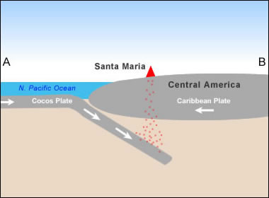
Simplified plate tectonics cross-section showing how Santa Maria Volcano is located above a subduction zone formed where the Cocos and Caribbean plates collide |
|
|
|
|
http://en.wikipedia.org/wiki/Volc%C3%A1n_Tajumulco |
Guatemala Volcanoes |
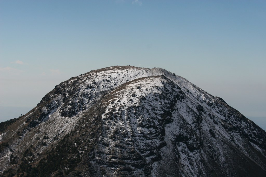
Tacana, Stratovolcano is a 4060-m-high composite stratovolcano that straddles the Mexico/Guatemala border at the NW end of the Central American volcanic belt. The volcano rises 1800 m above deeply dissected plutonic and metamorphic terrain. The elongated summit region is dominated by a series of lava domes intruded along a NE-SW trend. Volcanism has migrated to the SW, and a small adventive lava dome is located in the crater of the youngest volcano, San Antonio, on the upper SW flank. Viscous lava flow complexes are found on the north and south flanks, and lobate lahar deposits fill many valleys. Radial drainages on the Guatemalan side are deflected by surrounding mountains into the Pacific coastal plain on the SW side of the volcano. Historical activity has been restricted to mild phreatic eruptions, but more powerful explosive activity, including the production of pyroclastic flows, has occurred as recently as about 1950 years ago Tacana volcano eruptions:1855(?), 1878, 1949-50, 1986, Typical eruption style:Explosive.Last earthquakes nearby http://www.volcanodiscovery.com/volcanoes/mexico/tacana/ http://www.volcanodiscovery.com/volcanoes/mexico/tacana/ |
Tocana, more photos on http://www.skyscrapercity.com/showthread.php?t=892280&page=35 |
Tocana, photos on http://www.skyscrapercity.com/showthread.php?t=892280&page=35 |
http://en.wikipedia.org/wiki/Volc%C3%A1n_Tacan%C3%A1 Tacana is a 4060-m-high composite stratovolcanot. The volcano rises 1800 m above deeply dissected plutonic and metamorphic terrain. The elongated summit region is dominated by a series of lava domes intruded along a NE-SW trend. Volcanism has migrated to the SW, and a small adventive lava dome is located in the crater of the youngest volcano, San Antonio, on the upper SW flank. Viscous lava flow complexes are found on the north and south flanks, and lobate lahar deposits fill many valleys. Radial drainages on the Guatemalan side are deflected by surrounding mountains into the Pacific coastal plain on the SW side of the volcano. Historical activity has been restricted to mild phreatic eruptions, but more powerful explosive activity, including the production of pyroclastic flows, has occurred as recently as about 1950 years ago http://www.authenticmaya.com/volcanoes.htm |
http://www.volcanolive.com/mexico.html |
http://www.summitpost.org/acatenango/402069/c-401818 |
http://en.wikipedia.org/wiki/4000_meter_peaks_of_M%C3%A9xico#Highest_major_summits |
Tacana 15.13 N, 92.11 W,summit elevation 4110 m , stratovolcano , consists of a broad symmetrical cone with a diameter of 10 km at the base. It is located near the boundary between the North American and Caribbean Tectonic Plates. The main summit consists of an 80 m high andesitic dome, located inside an eroded 600-m wide crater.A Pelean type eruption occurred at San Antonio dome 1,950 years ago, and is the last significant magmatic event at Tacana volcano.Historic activity of Tacana has consisted of phreatic explosions (1855, 1878, 1949�1950 and 1986), which occurred at Tacan� and San Antonio domes.Tacana currently has an active volcano�hydrothermal system with fumarolic activity (89�C) at 3,600 m altitude, and thermal springs at the base of the volcano (1,500�2,000 m altitude). Fumarolic activity is located in two 15 m diameter explosion craters. The summit dome does not contain fumaroles. In May 1986, a seismic swarm was followed by a small phreatic explosion at an elevation of 3,600 m on the northwest flank of the volcano. This eruption reactivated fumarolic activity at Tacana.Eruptions 1986, 1949-50, 1878, 1855 http://www.volcanolive.com/guatemala.html http://www.summitpost.org/acatenango/402069/c-401818 |
Tocana |
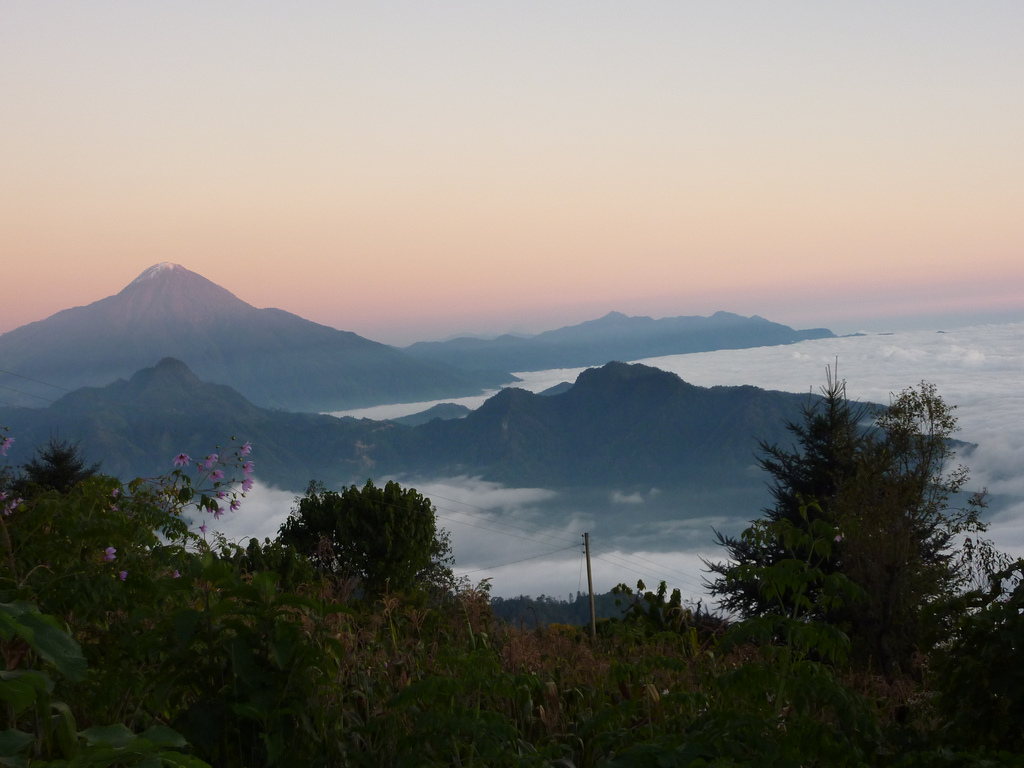
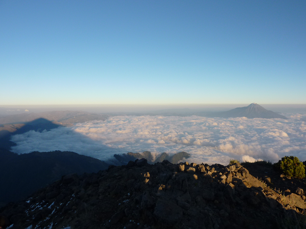
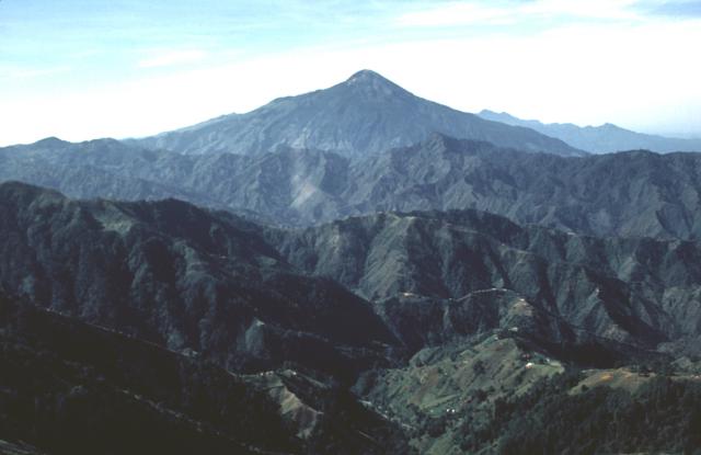
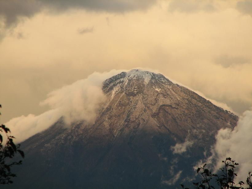
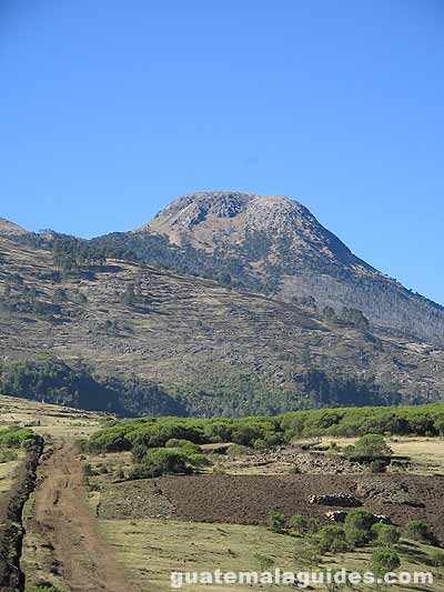
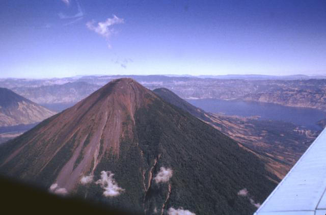
Tajumulco Volcano 4220 m, view from Pacific. Tajumilco 15.03 N, 91.90 W, 4220 m. The volcano contains two cones. The lower wester cone doesn''t contain a crater. The higher eastern cone has a 50 m diameter crater.Tajumulco has had several unconfirmed reports of historical eruptions.1863?, 1821? http://www.volcanolive.com/guatemala.html |
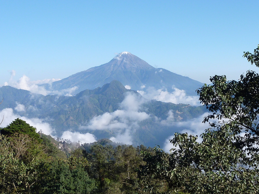
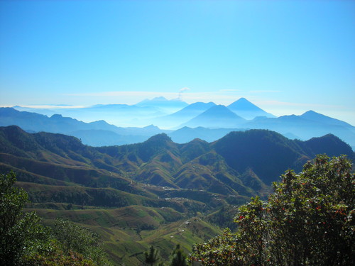
View of Tajumulco Volcano from Guatemalan High Plateau |
Volcan Tajumulco, Sierra Madre range, last eruption December 20,2008, is a large stratovolcano, 4,220 m. Tajumulco has had several historical reports of volcanic eruptions, but none have been confirmed to be true eruptions. |
Tojumulco |
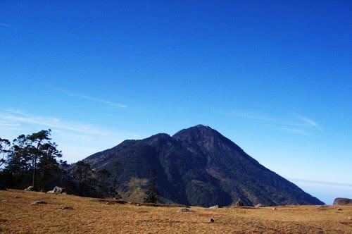
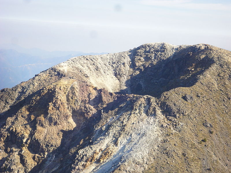
Volcan Tajumulco,Tajumulco is Guatemala''s highest peak and the highest volcano in Central America. Two summits, one with a 50-70 m wide crater, lie along a NW-SE line. A lava flow from the 4220-m-high NW summit traveled down a deep valley on the NW flank. The andesitic-dacitic volcano was constructed over the NW end of a large arcuate SW-facing escarpment of uncertain origin. Tajumulco has had several unconfirmed reports of historical eruptions. Sapper (1917) considered Tajumulco to have erupted during historical time, but without accurate dates. The volcano was reported to eject many rocks, destroying houses on October 24, 1765, but this may have been a rock avalanche. Juarros reported some eruptions before 1808, and there are unlikely reports of eruptions in 1821 (or 1822), 1863, and 1893 (Incer 1988, unpublished manuscript). ht http://www.authenticmaya.com/volcanoes.htm |
South side from a helicopter |
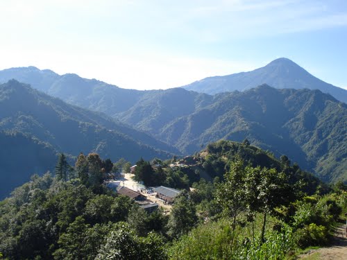
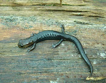
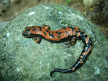
The terrestrial salamander Pseudoeurycea goebeli, one of the commonest 40 years ago on the cloud forest slopes of the Tajumulco volcano, has now disappeared. This specimen was photographed at a neighboring volcano, Chicabal, only 50 kilometers to the east of Tajumulco, where the salamander is much reduced in population-http://berkeley.edu/news/media/releases/2009/02/09_salamander.shtml |
The salamander Bolitoglossa lincolni, which lives in a variety of habitats in the cloud forest above 2,400 meters elevation, is as abundant today as it was 40 years ago http://berkeley.edu/news/media/releases/2009/02/09_salamander.shtml |
http://geology.com/volcanoes/santa-maria/ |
|
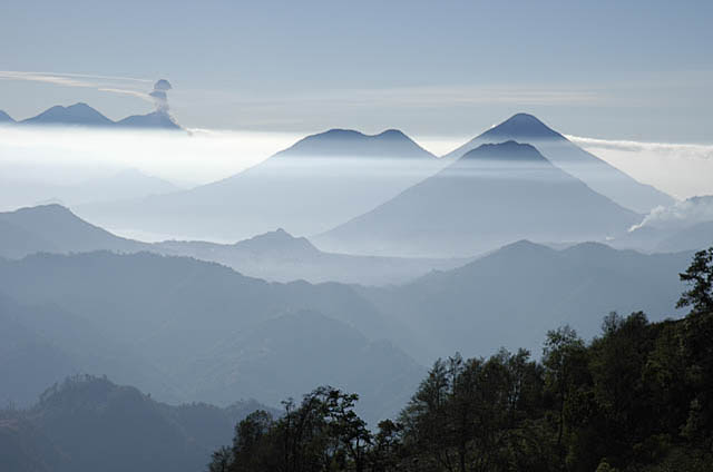
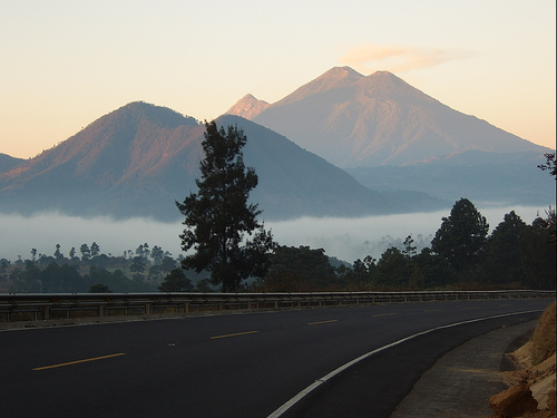
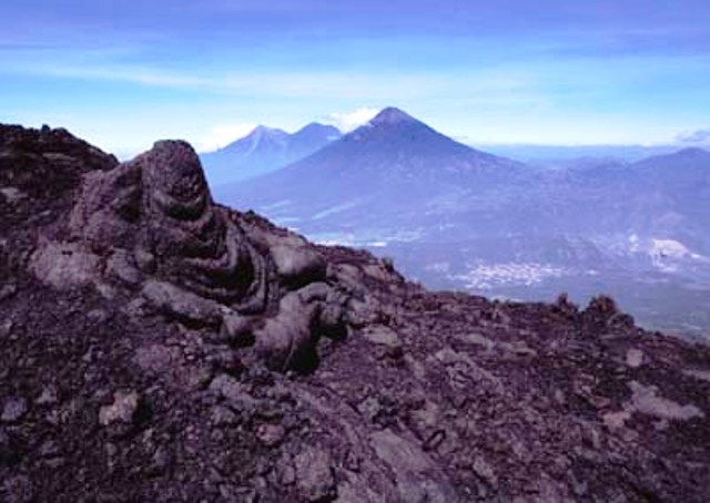
View of the Atitalan and Antigua volcanoes from the ridge leading to Zunil |
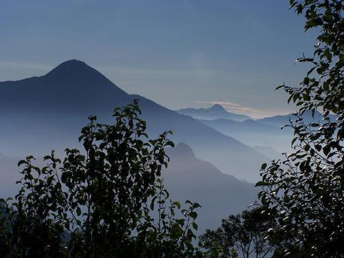
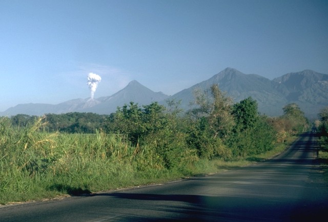
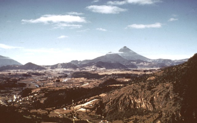
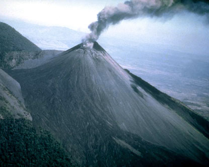
View from south to Santa Maria |
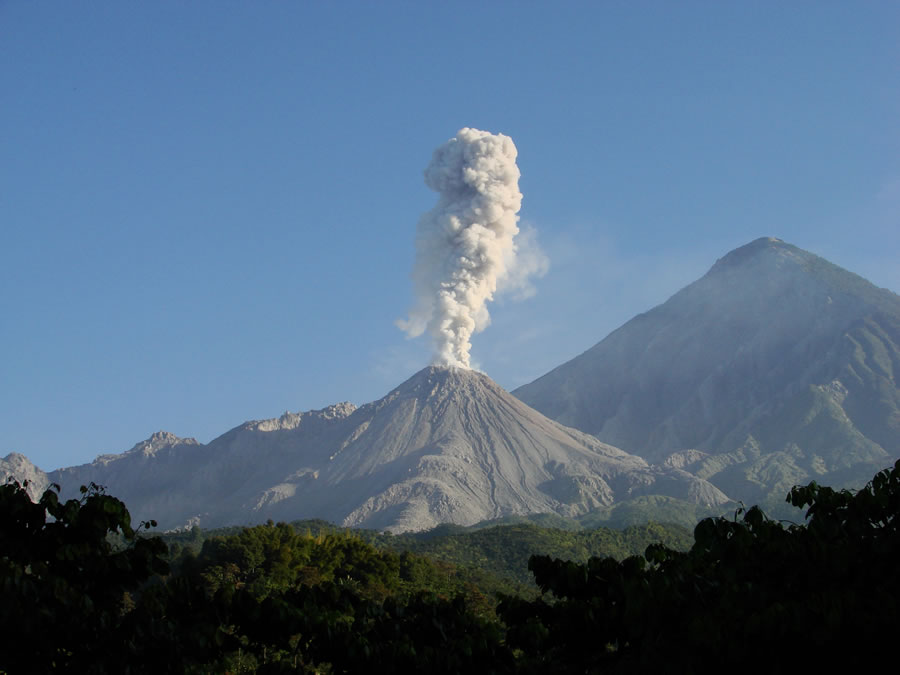
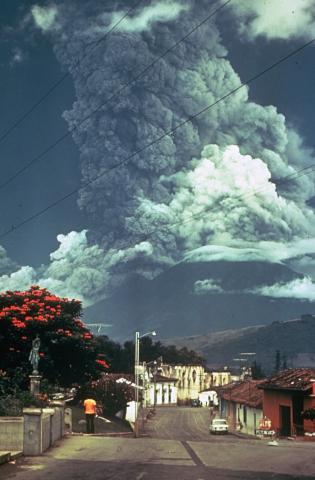
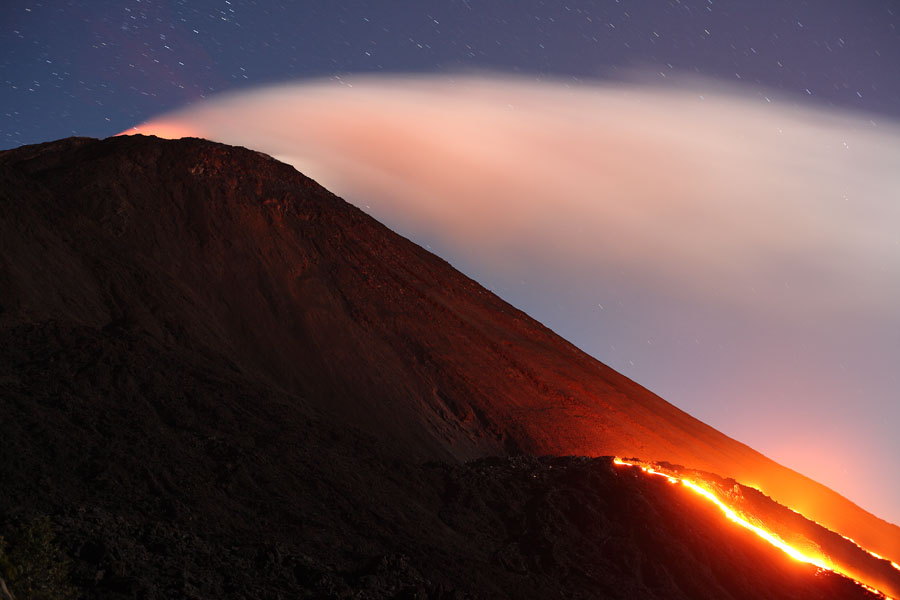
Santa Maria volcano, the most active in Guatemala, has a sharp-topped, conical profile that is cut on the SW flank by a large, 1-km-wide crater formed during a catastrophic eruption in 1902. The large dacitic Santiaguito lava-dome complex (center) has been growing at the base of the 1902 crater since 1922. Lava flows can be seen extending down the flank of the compound lava dome, whose growth is accompanied by a frequent minor explosions, along with periodic lava extrusion, larger explosions, pyroclastic flows, and lahars -http://www.authenticmaya.com/volcanoes.htm Santa Maria is a ~30,000 year old andesitic stratovolcano built on a basement of older rocks formed by ancient volcanic eruptions. The 0.5 km3 crater in the south flank of the volcano exposes a spectacular sequence of alternating pyroclastic and lava flows and lahar deposits. The crater was formed by a massive Plinian eruption in 1902. Following the 1902 eruption, the dacitic lava domes of Santiaguito began forming in the crater. The dome complex has since grown to include four domes totaling more than 1 km3 of material. The domes rise more than 500 meters (1,600 feet) above the base of the stratovolcano. While the main cone of Santa Marнa is no longer active, the domes of Santiaguito have created a number of volcanic hazards since their growth began. The land around the volcano has been used for agriculture for centuries, especially coffee plantations, which puts the people living and working there in continual danger. The towns of El Palmar and San Felipe - which are located directly south of the domes - and the city of Quetzaltenango to the north of Santa Maria, are several places that often have to deal with hazards from the volcano. The bulk of the domes were built by the extrusion of lava flows and spines, but the dacite lava is so viscous that it poses no immediate hazard on eruption. Collapses of the spines, the tips of the lava flows, or larger portions of the domes themselves can, however, create dangerous pyroclastic flows; the collapse of material in eruption columns formed by ash-and-gas explosions can also create pyroclastic flows. Drifting ash from eruptions often lands on the towns and cities near the volcano, and can cause hazardous breathing conditions as well as damaging crops. Finally, lahars (volcanic mudflows) are an especially common hazard in the streams and rivers below the domes, since this area of Guatemala experiences an intense summer rainy season. Water falling on the slopes of Santa Marнa and on the domes mixes easily with loose ash and rock and washes quickly downhill, choking the rivers below with mud and boulders. The original town of El Palmar was destroyed by lahars in the 1980s, and the new town could still be threatened by future mudflows.http://geology.com/volcanoes/santa-maria/ |
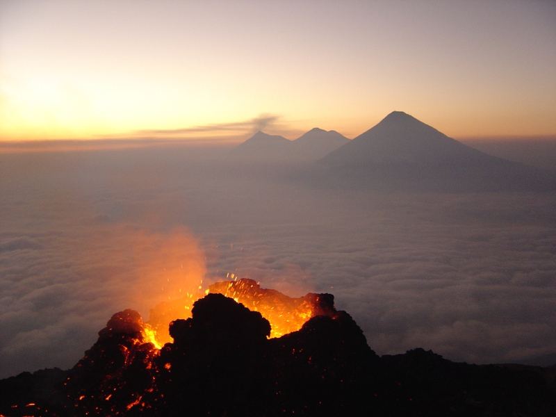
Santa Maria, 3772m, last eruption 2010, ongoing, a stratovolcano in the southwestern Guatemalan volcanic highlands, is the site of one of the twentieth century''s largest eruptions. It is also the home of Santiaguito, one of the most active lava dome complexes in the world. The group of four lava domes formed at the foot of Santa Maria twenty years after the volcano''s devastating 1902 eruption, and the domes have been growing ever since. The currently active dome, El Caliente, is the site of regular ash-and-gas explosions, and this minor but persistent activity has drawn many tourists to catch a glimpse of explosive silicic eruptions. Santa Maria is located in the volcanic highlands of Guatemala, which parallel the Pacific coast of the country. The highlands were formed by the subduction of the Cocos plate under the Caribbean plate, which resulted in the formation of a line of stratovolcanoes that stretches along much of the Pacific coast of Central America. In Guatemala, these volcanoes overlie a basement of carbonate as well as igneous and metamorphic rocks; many xenoliths ("foreign" rock fragments) found in lavas erupted from the stratovolcanoes are composed of limestone, granite, and gneiss -. http://geology.com/volcanoes/santa-maria/ |
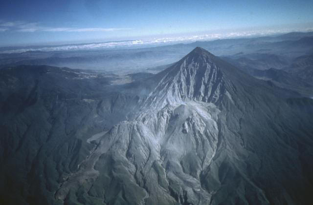
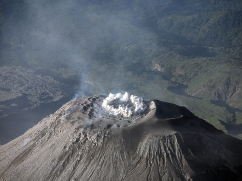
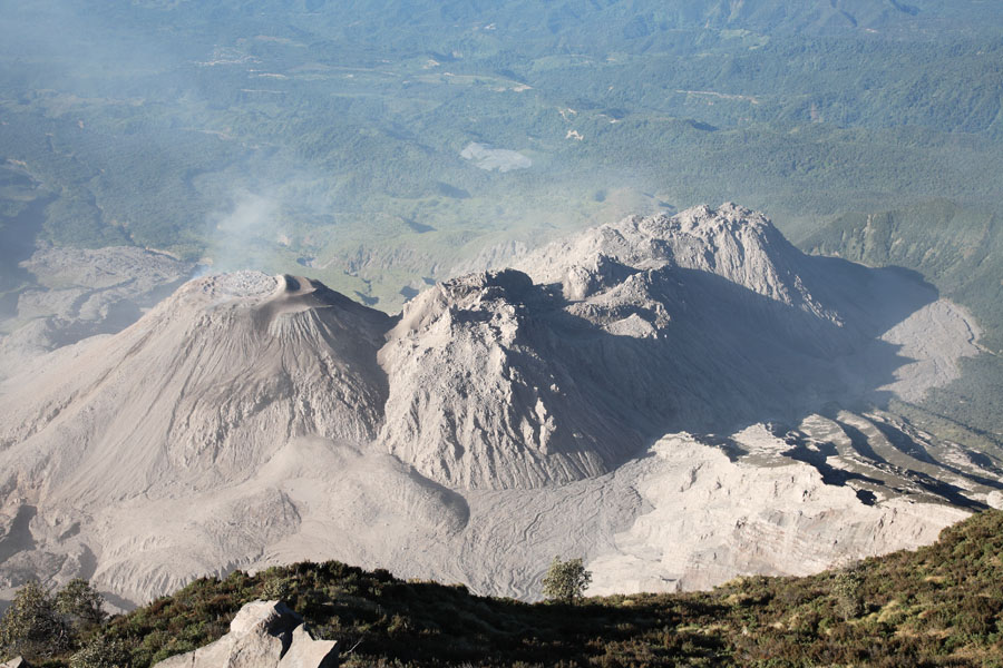
Santa Maria. santiago dome complex.This photo was taken during an aerial survey in Guatemala. The photo was captured at 21200 feet in an Aerocommander 690. There is no historical record of eruption at Santa Maria. The oldest lava flows that make up the volcano are ~30,000 years old, but there are few dates for younger deposits. Magnetic data suggests that most of the growth occurred during a 1000 to 3000 year period prior to 25,000 years ago, although more accurate dates are not yet available. The cone-building period was followed by a long period of quiescence interrupted by occasional small-volume lava flows from flank vents. (Conway et al, 1993) . In November 1902, following several large earthquakes that caused significant damage in Guatemala and neighboring countries, Santa Maria experienced one of the biggest eruptions in the twentieth century. It lasted for several weeks, created an 0.5 km3 (0.1 mi3) crater in the volcano''s south flank, and spread more than 5 km3 (1.2 mi3) of tephra as far away as Mexico. The eruption crater continued to be active for some months afterward, with several geysers erupting from a short-lived crater lake. In 1922, new seismic activity heralded the eruption of a single dacitic lava dome in the 1902 crater. The dome, initially named Santiaguito, grew quickly, reaching 0.2 km3 (0.05 mi3) in only three years. A devastating dome collapse occurred in 1929, sending pyroclastic density currents down the river valleys below the domes; more than 3,000 people were killed and the plantations in the path of the pyroclastic flows were destroyed. Following this collapse, activity at Santiaguito began to move westward from the original vent (now called Caliente), eventually forming three more lava domes (La Mitad, El Monje, and El Brujo) by the 1960s. From 1972-1975, both Caliente and El Brujo (the domes on either end of the complex) were active at the same time, producing lava flows, pyroclastic flows, and ash-and-gas eruptions. Activity has been restricted to the Caliente dome since 1975, and has included regular ash-and-gas eruptions from the dome summit as well as lava flows that travel down its flanks. Caliente has experienced several significant events since the 1929 dome collapse, including large eruptions and pyroclastic flows in 1973, 1989, and most recently in April of 2010. http://geology.com/volcanoes/santa-maria/ |
Santa Maria Volcano with the Santiaguito lava dome complex in the foreground. The erupting dome is El Caliente ("the hot one"). |
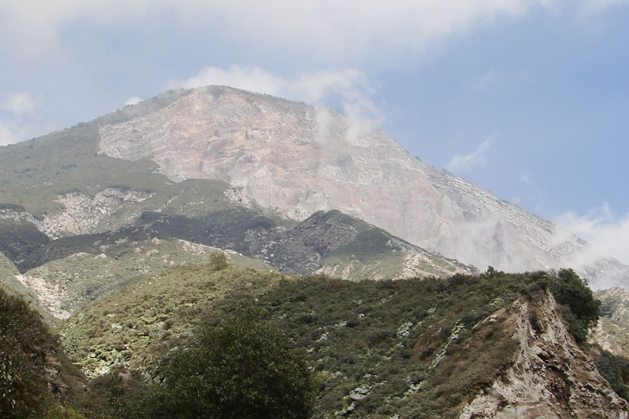
From the base of the domes, the alternating layers of lava flows and pyroclastic flow deposits are clearly exposed in the walls of the 1902 eruption crater in the cone of Santa Marнa. Such layering is typical of stratovolcanoes, although the layers are rarely so regular and uninterrupted. Image © by Jessica Ball. http://geology.com/volcanoes/santa-maria/ |
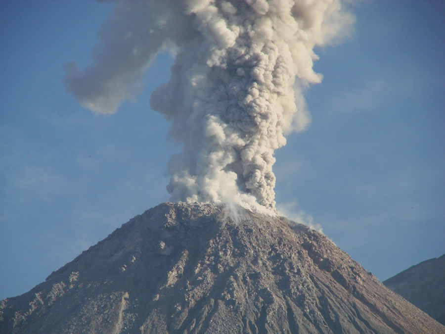
Close-up of an ash-and-gas eruption from the summit of El Caliente. The dome tends to erupt in this fashion every few hours, making it one of the best places to safely view an explosive volcanic eruption. Image © by Jessica Ball http://geology.com/volcanoes/santa-maria/ |
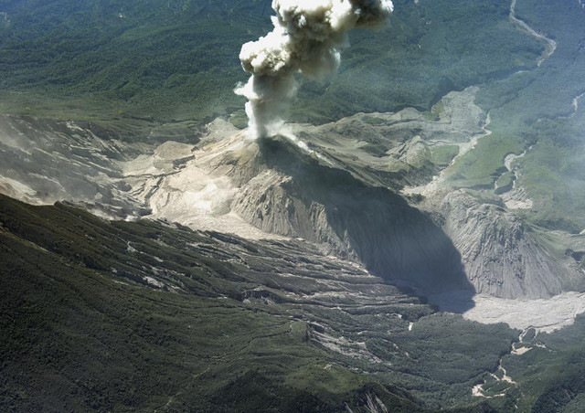
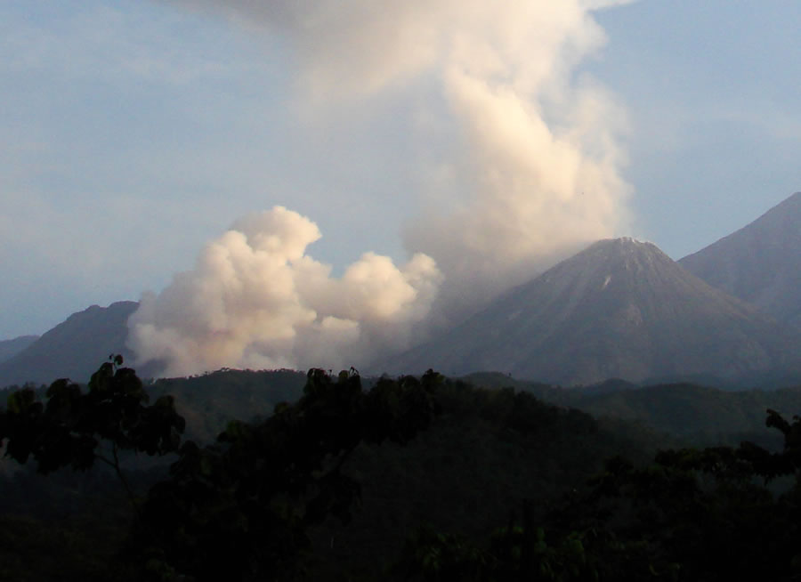
A small pyroclastic flow descending the slope of the El Caliente lava dome. Small pyroclastic flows usually do not travel far beyond the domes, but large ones can flow many miles downstream and cause considerable damage. Image © by Jessica Ball http://geology.com/volcanoes/santa-maria/ |
http://www.tboeckel.de/EFSF/efsf_wv/sm-Santeaguito_07/Santeaguito_07_e.htm |
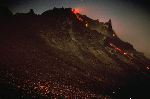
Incandescent areas are visible at the top of the growing Santiaguito lava dome in Guatemala. Rockfalls from the dome produce a glowing trail down its northern flanks. The Santiaguito dome began growing in 1922 in a large crater formed on the SW flank of Santa Maria volcano during a powerful explosive eruption in 1902. Dome growth has been continuous since 1922 and has produced a composite, elongated dome more than 3 km long. This photo of El Brujo, the westernmost vent, was taken on November 12, 1967. PHOTO SOURCE: Charles pineo 1967, Dartmouth College, courtesy of Dick Stoiber, courtesy of the Global Volcanism Program, Smithsonian National Museum of Natural History http://www.geographic.org/photos/volcanoes/volcano_photos_65.html |
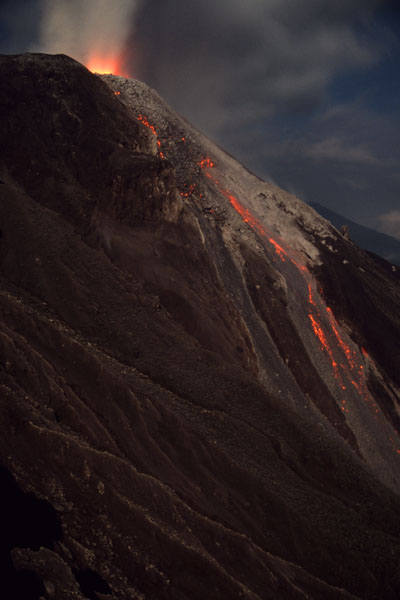
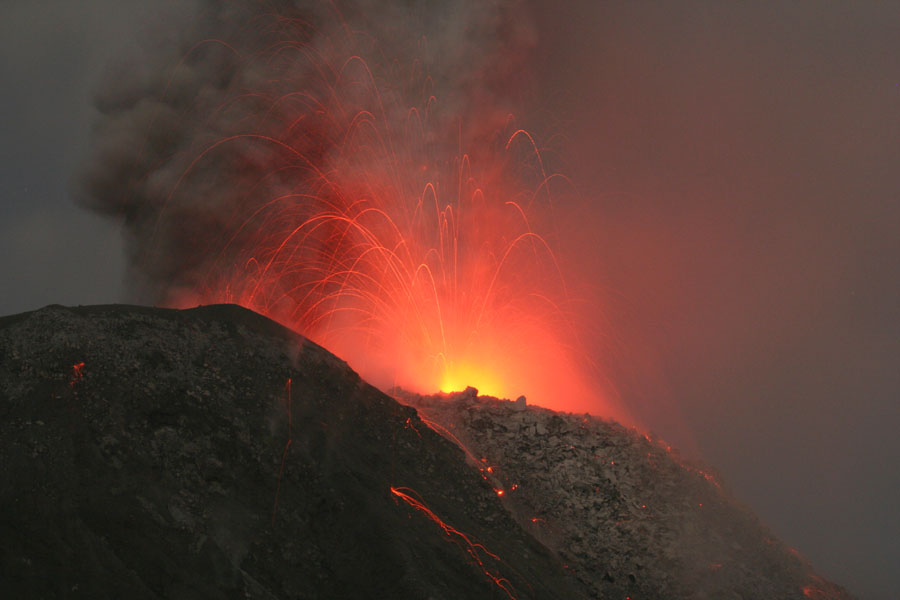
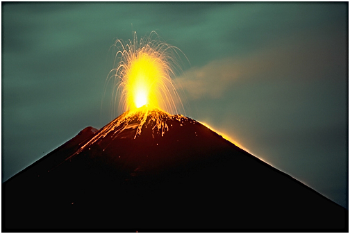
Nighttime eruption of Calient Vent with incandscent rockfalls. Viewed from El Brujo dome, December 2005http://www.photovolcanica.com/Pictures_V1/Picture_v1_vp1.html |
Santiaguito is a lava dome on the flank of Santa Maria, which has been continuously active since 1922 -http://www.tboeckel.de/EFSF/efsf_wv/sm-Santeaguito_07/Santeaguito_07_e.htm Accompanied by load roaring noise |
Nighttime eruption of Calient Vent. Viewed from inactive El Brujo dome, December 2005 -http://www.photovolcanica.com/VolcanoInfo/Santiaguito/Santiaguito.html |
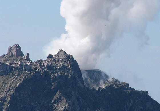
The first morning light let now the domes appears in a full view, and with a complete change of the eruption behavior it was possible to take this photos. Eruption of vent at perimeter of ring structure. Eruption of vent at perimeter of ring structure. This vent also strongly contributed to ring fracture eruptions |
http://www.tboeckel.de/EFSF/efsf_wv/sm-Santeaguito_07/Santeaguito_07_e.htm |
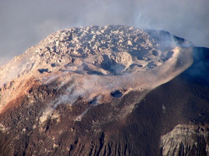
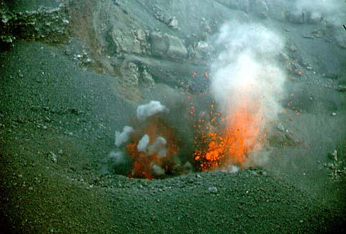
Onset of ring fissure eruption. Note that ring corresponds to perimeter of blocky area in picture above which marks top of magma column. Eruption at Summit of Santiaguito Dome Complex, Caliente vent, Santa Maria Volcano |
Summit of Santiaguito Caliente dome. Santiaguito is a dacitic lava dome complex which has been growing since 1922 in the crater left by the catastrophic 1902 eruption of Santa Maria volcano. Recent activity has involved small explosions, incandescent rockfalls, emission of block lava flows and dome inflation. Pyroclastic flows generated by collapses at lava flow fronts or resulting from dome collapses have also sporadically occurred. A major indirect impact of activity has been the frequent mobilization of loose volcanic material during the rainy season, which has resulted in numerous lahars (mudflows). Lahar sediments, which may be many meters thick, can block rivers and change their courses. However, they are themselves easily eroded and massive erosion gulleys scar the landscape between Santiaguito and the pacific coast. Santa Maria, Guatemala: Bimodal soda-rich calcalkalic stratovolcano - http://www.geo.mtu.edu/~raman/index/SantaMaria.html |
Santiaguito 2520 m Crater, Quetzaltenango |
Santiaguito Lava Dome Complex: El Monje, La Mitad and El Caliente lava domes viewed from the El Brujo dome. The slopes of El Caliente are scoured by rockfalls and pyroclastic flows, but the inactive domes to the west are covered in lush vegetation. Image © by Jessica Ball http://geology.com/volcanoes/santa-maria/ |
Santiaguito lava dome complex viewed from Santa Maria, Dec. 2007-http://www.photovolcanica.com/VolcanoInfo/Santiaguito/Santiaguito.html |
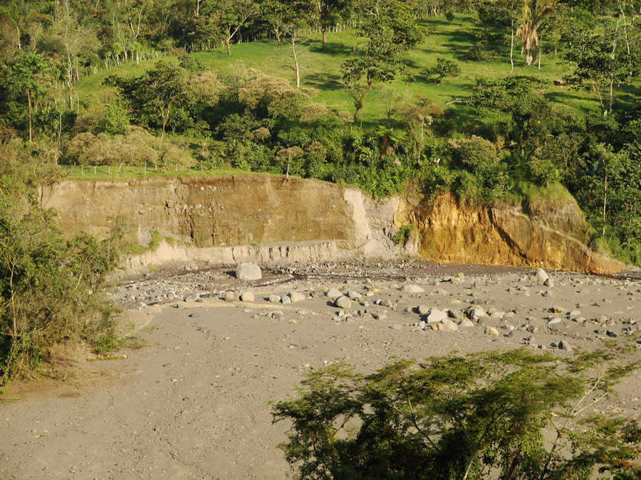
A several-meter-thick deposit of pumice and lava fragments from the 1902 eruption is overlain by even thicker mudflows in this river channel south of Santiaguito. The large boulders in the river were deposited there by recent lahars, which are a continuing hazard for the many farms and plantations below the volcano. Image © by Jessica Ball http://geology.com/volcanoes/santa-maria/ |
Totonicapan |
Cuxliquel, 2160m |
Zunil 3542 m |
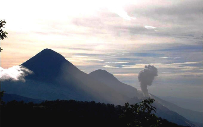
Volcan Santo Tomas is the sharp peak on the right-center horizon rising above the Pacific coastal plain. A winding ridge connects Santo Tomas to Volcan de Zunil, 4.5 km to the NE, a 3542-m-high stratovolcano that forms the topographic high point of the complex at the extreme right. No Holocene eruptions are known from Santo Tomas, although there are active solfatara fields. An eruption plume rises from Santiaguito lava dome on the flank of conical Santa Maria volcano, across the Rio Samala to the west.Volcan Santo Tomas is a large eroded stratovolcano. The summit of the volcano is capped by late-Quaternary andesitic tephra. A winding ridge connects Santo Tomas to Volcan de Zunil, 4.5 km to the NE, a 3542-m-high stratovolcano that forms the topographic high point of the Santo Tomбs - Zunil complex. Volcбn de Zunil is located on the SW rim of the 4-km-wide, 600-m-deep Tzanjuyub caldera, which is breached to the south by the Rнo Masa. Several dacitic-rhyolitic lava domes are located on the caldera''s northern flank and the NW flank of Volcan de Zunil. The youngest dome, Cerro Zunil, was last active about 84,000 years ago (K-Ar dating). No Holocene eruptions are known from Santo Tomбs, although it was included in the Catalog of Active Volcanoes of the World (Mooser et al., 1958) based on its geothermal activity. Solfataras and thermal springs are located on the west side of the ridge between Santo Tomбs and Zunilhttp://www.authenticmaya.com/volcanoes.htm "Cerro Zunil" the name of its youngest and most prominent dome which was last active approximately 84,000 years ago (K-Ar dating).Geothermal activity can be observed in the form of Solfataras and thermal springs which are located on the west of the ridge between Santo Tomas and Zunil. http://en.wikipedia.org/wiki/Volc%C3%A1n_Santo_Tom%C3%A1s Pleistocene-Fumarolic volcano, Volcan Santo Tomas is a large eroded stratovolcano located across a valley SE of Santa Maria volcano. The summit of the volcano is capped by late-Quaternary andesitic tephra. A winding ridge connects Santo Tomбs to Volcan de Zunil, 4.5 km to the NE, a 3542-m-high stratovolcano that forms the topographic high point of the Santo Tomas - Zunil complex. Volcan de Zunil is located on the SW rim of the 4-km-wide, 600-m-deep Tzanjuyub caldera, which is breached to the south by the Rнo Masa. Several dacitic-rhyolitic lava domes are located on the caldera''s northern flank and the NW flank of Volcбn de Zunil. The youngest dome, Cerro Zunil, was last active about 84,000 years ago (K-Ar dating). No Holocene eruptions are known from Santo Tomбs, although it was included in the Catalog of Active Volcanoes of the World (Mooser et al., 1958) based on its geothermal activity. Solfataras and thermal springs are located on the west side of the ridge between Santo Tomas and Zunil. http://www.volcano.si.edu/world/volcano.cfm?vnum=140204=A Santo Tomas, summit elevation 3542 m, stratovolcano . Solfataras and thermal springs are located on the west side of the ridge between Santo Tomas and Zunil. Eruption 84,000 years ago http://www.volcanolive.com/guatemala.html |
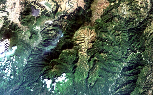
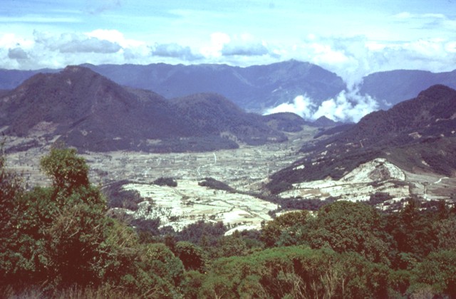
The light-colored, furrowed area at the top-center is the 4-km-wide, 600-m-deep Tzanjuyub caldera, which is breached to the south by the Rio Masa. At the SW side of the Pleistocene caldera is Volcбn Zunil, which is connected by an irregular ridge to Volcбn Santo Tomбs, a large eroded stratovolcano above the clouds at the bottom of the image. Santa Maria volcano (far left-center) lies across the Rнo Samalб to the east. Solfataras and thermal springs are located on the west side of the ridge between Santo Tomas and Zunil.NASA Landsat image, 2000 (courtesy of Loren Siebert, University of Akron). http://www.volcano.si.edu/world/volcano.cfm?vnum=140204=A&volpage=photos |
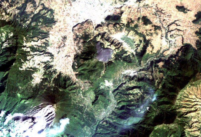
The arcuate area at the top center below the light-colored city of Quetzaltenango is the Almolonga volcanic complex. An arcuate series of lava domes outlines the northern part of the complex, while the unvegetated area to the south is the 1818 lava flow from Cerro Quemado volcano, the youngest of the Almolonga complex. Almolonga is located along the Zunil fault zone, which extends diagonally SW along the Rio Samala (bottom-center). The furrowed 1902 crater of Santa Maria volcano lies at the lower left.NASA Landsat image, 2000 (courtesy of Loren Siebert, University of Akron). http://www.volcano.si.edu/world/volcano.cfm?vnum=1402-04=&volpage=photos |
The arcuate area at the top center below the light-colored city of Quetzaltenango is the Almolonga volcanic complex. An arcuate series of lava domes outlines the northern part of the complex, while the unvegetated area to the south is the 1818 lava flow from Cerro Quemado volcano, the youngest of the Almolonga complex. Almolonga is located along the Zunil fault zone, which extends diagonally SW along the Rio Samala (bottom-center). The furrowed 1902 crater of Santa Maria volcano lies at the lower left.NASA Landsat image, 2000 (courtesy of Loren Siebert, University of Akron). http://www.volcano.si.edu/world/volcano.cfm?vnum=1402-04=&volpage=photos http://www.volcano.si.edu/world/volcano.cfm?vnum=1402-04= Volcan de Almolonga, 3197m, is an andesitic stratovolcano with a 3.3-km-wide late-Pleistocene central caldera that is located along the Zunil fault zone. The caldera is surrounded by a ring-dike configuration of dacitic and rhyolitic lava domes. The youngest and only historically active dome complex is Cerro Quemado (whose name means Burned Peak), located immediately south of Guatemala''s second largest city, Quetzaltenango. About 1200 radiocarbon years ago, part of the andesitic-to-dacitic Cerro Quemado dome collapsed, producing a debris avalanche and an associated lateral explosion that swept across the valley to the west as far as the flanks of Siete Orejas volcano. The latest eruption in 1818 produced a blocky 2.5-km-long lava flow. Hot springs are located on the northern and eastern flanks of Cerro Quemado, and the Zunнl geothermal field, the site of a geothermal exploration project, lies on the SE flank of Cerro Quemadohttp://www.authenticmaya.com/volcanoes.htm The Almolonga volcano (Cerro Quemado) is an andesitic stratovolcano in the south-western department of Quetzaltenango The Volcano is set along the Zunil fault zone and has a central caldera surrounded by several dacitic and rhyolitic lava domes. Cerro Quemado is the largest and youngest lava dome complex and is the only one that has erupted (1818). The northern and eastern flanks of Cerro Quemado have hot springs. http://en.wikipedia.org/wiki/Almolonga summit elevation 3197 m, stratovolcano, an andesitic to dacitic dome complex. The volcano contains a caldera, lava domes, and hot springs. A geothermal exploration project is located on the SE flank of Cerro Quemado.A collapse of the volcano produced a 3.3 km diameter caldera, which was followed by eruption of Los Chocoyos ignimbrite. Eight post-caldera lava domes are located on the northern side of the caldera.Volcanic hazards at Almolonga volcano include lava flows, dome collapse, debris avalanche, pyroclastic flows, and lateral blast. An eruption in January 1818 produced a blocky lava flow that extended 2.5 km to the east and deposited tephra up to a meter thick. Earthquakes were felt by residents before and during the eruption.An eruption 1150 years ago produced a debris avalanche and lateral blast that covered an area of 40 sq km, and a volume of 0.13 cubic km. The avalanche deposit is visible as more than 150 hummocks, depressions, and boulder fields. The hummocks are circular to oval in shape, and range from 4 to 15 m high and 16 to 500 m in diameter.Eruption 1765 http://www.volcanolive.com/guatemala.html |
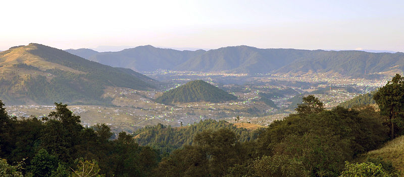
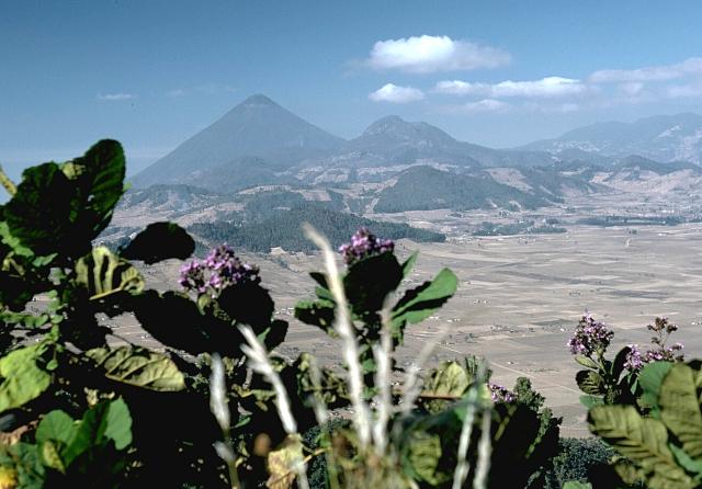
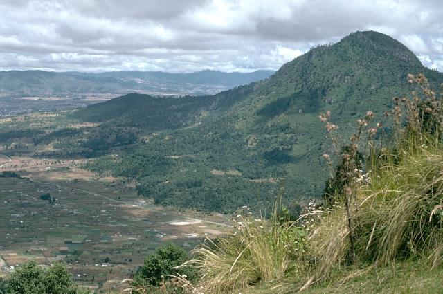
The line of low forested lava domes in the center of the photo marks a chain of domes erupted along the rim of the Pleistocene caldera of the Almolonga volcanic field. The highest dome, Cerro Quemado, is the peak seen here from the north with a cloud-draped summit. It lies below and to the left of Santa Marнa volcano, the sharp-topped peak at the right-center. Almolonga stratovolcano collapsed to form a 3.3-km-wide caldera sometime prior to 85,000 years ago. Post-caldera eruptions produced eight andesitic-to-dacitic lava domes |
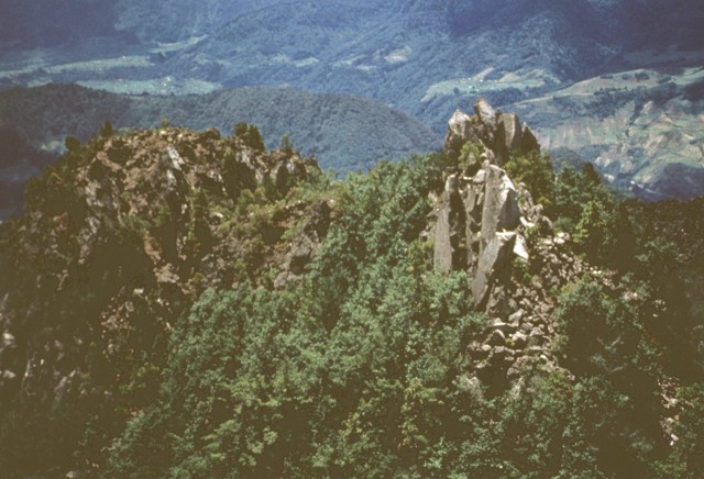
The forested Cerro Quemado lava dome (left), seen here from Siete Orejas volcano, is one of a series of dacitic and rhyolitic lava domes constructed along the margin of the Almolonga caldera. The central dome complex of Cerro Quemado was erupted during the Holocene from at least 8 vents arranged in a circular pattern. One of these flank vents forms the low rounded ridge below the center horizon. Santa Maria volcano lies just out of view to the right, and the western side of the Santo Tomбs (Pecul) volcanic complex forms the horizon.Photo by Bill Rose, 1975 (Michigan Technological University). |
Blocky lava spines bristle along the summit ridge of Cerro Quemado volcano, the youngest of a series of andesitic and dacitic domes erupted along the margins of Almolonga volcano. The early stages of the Cerro Quemado complex produced a sequence of lava flows and domes erupted from at least eight vents. During the later stages, about 1150 years ago, the summit dome of Cerro Quemado was emplaced following failure of the summit of the complex. The only historical eruption took place from an east-flank vent in 1818. Photo by Bill Rose, 1972 (Michigan Technological University). http://www.volcano.si.edu/world/volcano.cfm?vnum=1402-04=&volpage=photos |
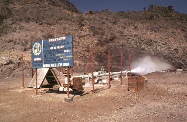
The Zunil geothermal project is seen here in 1981, a decade prior to a landslide that buried the well site |
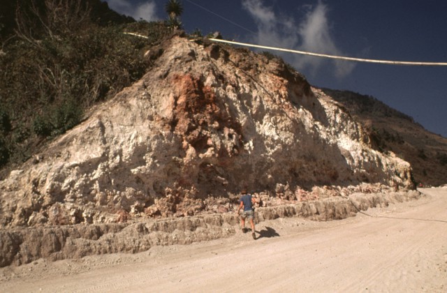
Bedrock in the area of the Zunil geothermal field on the SE flank of Cerro Quemado volcano is extensively hydrothermally altered. The geothermal area is located along the Zunil fault zone, which juxtaposes brownish-red weathered to lightly altered andesitic-dacitic lava flows with white-to-pink heavily altered and brecciated volcanic rock. Hydrothermal alteration minerals include kaolinite, pyrite, gypsum, and alunite. The NE-SW-trending left-lateral fault zone runs parallel to the valley of the Rio Samala.Photo by Bill Rose, 1981 (Michigan Technological University). |
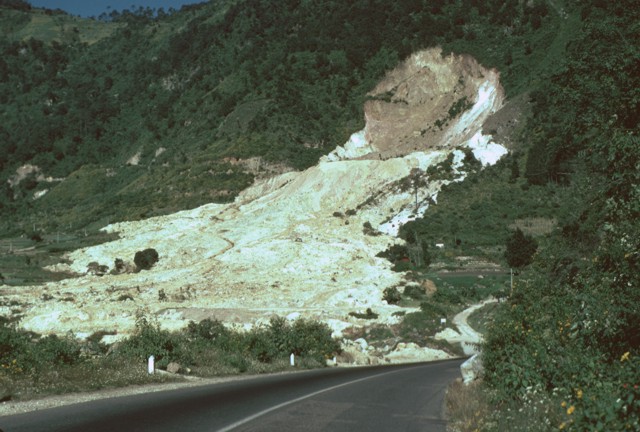
This view looks down the travel path of the January 5, 1991 landslide at the Zunil geothermal site. The avalanche of extensively hydrothermally altered material along the Zunil fault zone traveled 800 m from its source. The slide reached nearly to the R�Яo Samala and can be seen at the top of the photo cutting the highway between Quetzaltenango and Retalhuleu. The landslide consisted of four overlapping lobes with a combined thickness of only 2-3 m.Photo by Claus Siebe- http://www.volcano.si.edu/world/volcano.cfm?vnum=1402-04=&volpage=photos The light-colored area in the foreground is the trace of a landslide from the Zunil geothermal field that occurred on January 5, 1991. The landslide traveled 800 m from its source along the Zunil fault zone toward the Rio Samala and killed 23 persons living in small farms on the valley floor. Some of the survivors of the slide were treated for burns from the hot flow, which cut the highway between Quetzaltenango and the Pacific coast. This view looks along the RЁЄo SamalЁў valley to the NE with the flanks of Cerro Quemado volcano in the left background |
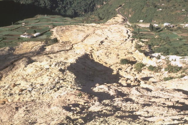
The 80-m-high headwall scarp of the January 5, 1991 landslide at the Zunil geothermal field is the beige-colored area that exposes the trace of the regional Zunil fault zone. The light-colored avalanche deposit extends about 800 m from the source and cut the highway between Quetzaltenango and the town of Retalhuleu on the Pacific coastal plain. The avalanche destroyed a church and more than a half dozen houses, killing 23 persons. The elevation difference from the head of the scarp to the distal end of the deposit was 250 m.Photo by Lee Siebert, 1993 (Smithsonian Institution). |
Cerro Quemado, seen here from the SW, is the youngest lava-dome complex of Volcan de Almolonga. Cerro Quemado is located immediately south of Guatemala''s second largest city, Quezaltenango, the outskirts of which are visible at the upper left. The dome complex consists of a series of biotite-bearing andesitic-to-dacitic lava domes and flows. About 1150 radiocarbon years ago, part of Cerro Quemado collapsed, producing a debris avalanche and an associated lateral explosion that swept across the Llano del Pinal, the plain at the lower left. Photo by Lee Siebert, 1993 (Smithsonian Institution). |
|
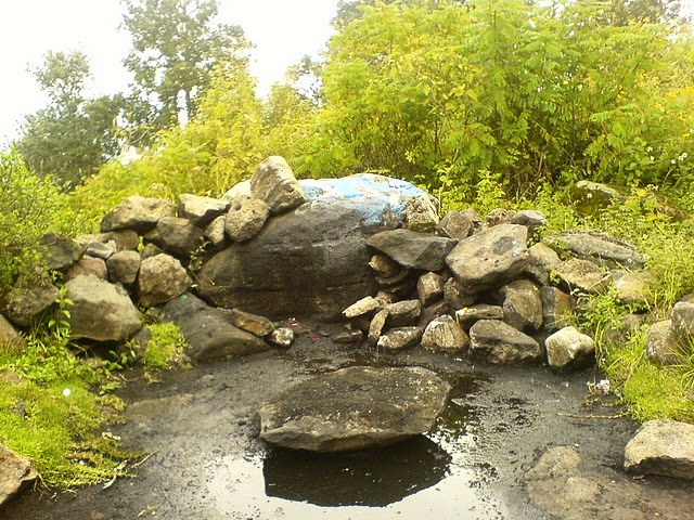
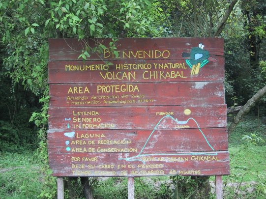
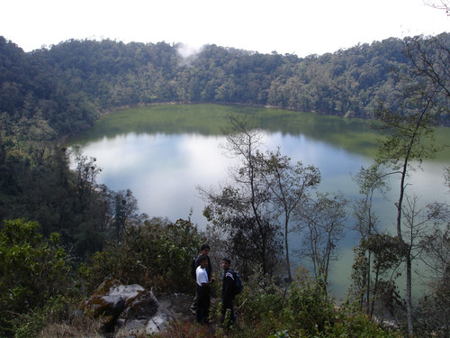
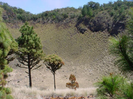
Volcan Chicabal, 2990 m, has a unique crater lake inside of its summit cone with a surface altitude of 2 700m. On clear mornings it is possible to see the major volcanoes of northwestern Guatemala as well as the Pacific coast. The crater rim and volcanic cone are covered in a lush cloud forest.Laguna Chicabal is still revered as sacred by the local Mayan population. Sacerdotes (Mayan priests) commonly practice rituals and ceremonies on the shores of the lake. |
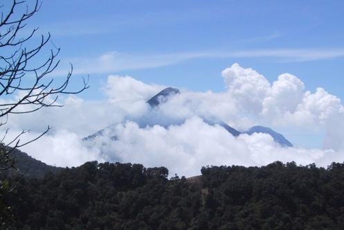
santa Maria volcano from Chicabal |
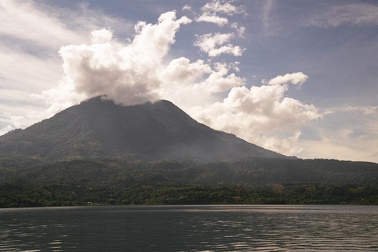
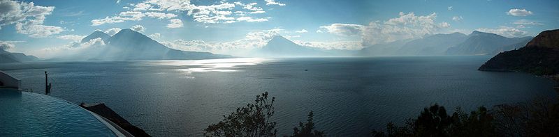
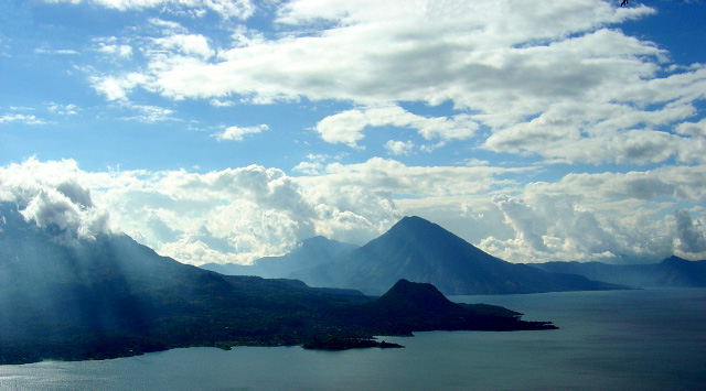
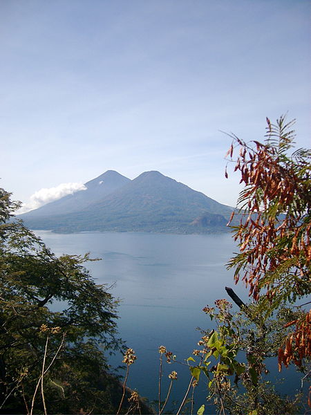
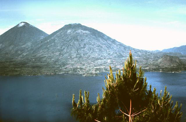
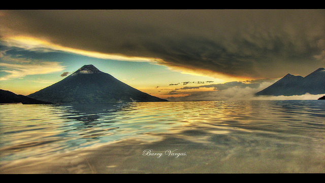
Volcan Atitlan is one of several prominent conical stratovolcanoes in the Guatemalan highlands. Along with its twin volcano Toliman to the north, it forms a dramatic backdrop to Lake Atitlan, one of the scenic highlights of the country. The 3535-m-high summit of Atitlбn directly overlies the inferred margin of the Pleistocene Atitlan III caldera and is the highest of three large post-caldera stratovolcanoes constructed near the southern caldera rim. The volcano consequently post-dates the eruption of the voluminous, roughly 85,000-year-old rhyolitic Los Chocoyos tephra associated with formation of the Atitlбn III caldera. The historically active andesitic Volcan Atitlan is younger than Toliman, although their earlier activity overlapped. In contrast to Toliman, Atitlan displays a thick pyroclastic cover. The northern side of the volcano is wooded to near the summit, whereas the upper 1000 m of the southern slopes are unvegetated. Predominantly explosive eruptions have been recorded from Volcбn Atitlбn since the 15th century http://www.authenticmaya.com/volcanoes.htm summit 3535 m, stratovolcano , the Highlands . The northern side of the volcano is wooded to near the summit, whereas the upper 1000 m of the southern slopes are unvegetated. Predominantly explosive eruptions have been recorded from since the 15th century.Three Quaternary composite cones, San Pedro, Toliman, and Atitlan, are found along the south side of the Lake Atitlan. Atitlan straddles the southern marginal fault of the Atitlan Cauldron. Erupted dominantly pyroclastic materials, in contrast to adjacent Toliman which has erupted viscous lava flows and domes. Eruptions 1856?, 1853, 1852?, 1843, 1837, 1833, 1827-28, 1827, 1826, 1717-21, 1663, 1579?-81, 1505?, 1469 http://www.volcanolive.com/guatemala.html |
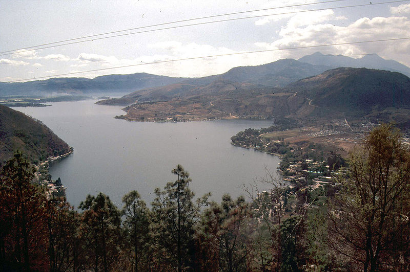
Volcan Atitlan, 3535 m, is a large, conical, active stratovolcano adjacent to the caldera of Lake Atitlan in the Highlands of Guatemala. The volcano has been quite active historically, with more than a dozen eruptions recorded between 1469 and 1853, the date of its most recent eruption. Atitlan is part of the Central American Volcanic Arc. The arc is a chain of volcanoes stretching along Central America formed by subduction of the Cocos Plate underneath the Caribbean Plate. These volcanoes are part of the Ring of Fire around the Pacific Ocean.Volcan Atitlбn is few miles south of Volcan Toliman, which rises from the southern shore of Lake Atitlan. Volcan San Pedro rises above Lake Atitlan northwest of Volcan Atitlan. A long narrow bay separates Volcan Atitlan and Volcan Toliman from Volcan San Pedro http://en.wikipedia.org/wiki/Volc%C3%A1n_Atitl%C3%A1n Lake Atitlan is rthe deepest lake in Central America, 340 m. The lake is shaped by deep escarpments which surround it and by three volcanoes on its southern flank. Volcan San Pedro is marked to the left in the image. The lake is one of the most beautiful lakes in the world, and is filling an enormous caldera formed in an eruption 84,000 years ago. The caldera-forming eruption is known as Los Chocoyos eruption, and ejected up to 300 km3 of rhyolitic magma. The enormous eruption dispersed ash over an area of some 6 million km²: it has been detected from Florida to Ecuador, and can be used as a stratigraphic marker in both the Pacific and Atlantic oceans (known as Y-8 ash in marine deposits). Since the end of Los Chocoyos, continuing volcanism has built three volcanoes in the caldera. Volcán Atitlán lies on the southern rim of the caldera, while Volcán San Pedro and Volcan Toliman lie within the caldera. San Pedro is the oldest of the three and seems to have stopped erupting about 40,000 years ago. Tolimán began growing after San Pedro stopped erupting, and probably remains active, although it has not erupted in historic times. Guatemala has a whole string of volcanoes situated in a volcanic arc formed by the subduction of the Cocos Plate beneath the Caribbean Plate. Atitlan Volcano had a strong eruption on 3 May 1853, when ash darkened the sky around Lake Atitlan. Aside from the eruptions of Vulcan Atitlan, little is known about unrest at Atitlan Caldera. Seismicity has been low during the past decade or more. There is a hint of relatively long-period fluctuations in lake level; the lake level was reportedly low in the 1820''s, 10-15 meters higher in the 1870''s, back down to its low level in the 1920''s, and high again from the 1940''s to the present. Most fluctuation is a result of variation in annual rainfall or the effects of regional earthquakes on the subsurface drainage from the lake; it is not known whether any uplift and subsidence of the caldera floor is involved. Short-term changes in lake level that are attributable to rainfall may be as great as the increase of 3.3 m during the exceptionally wet year of 1933; those attributable to earthquakes may be as great as the drop of 2 meters that occurred within one month following the Guatemala earthquake (magnitude=7.5) of 4 February 1976. Sediments of the lake floor suggest episodic, decades-long increases in sublacustrine thermal activity: alternating decades-long periods with and without annual lake overturn are interpreted as periods of relatively high and low activity of fumaroles on the caldera floor. http://my.opera.com/nielsol/blog/show.dml/4895401 |
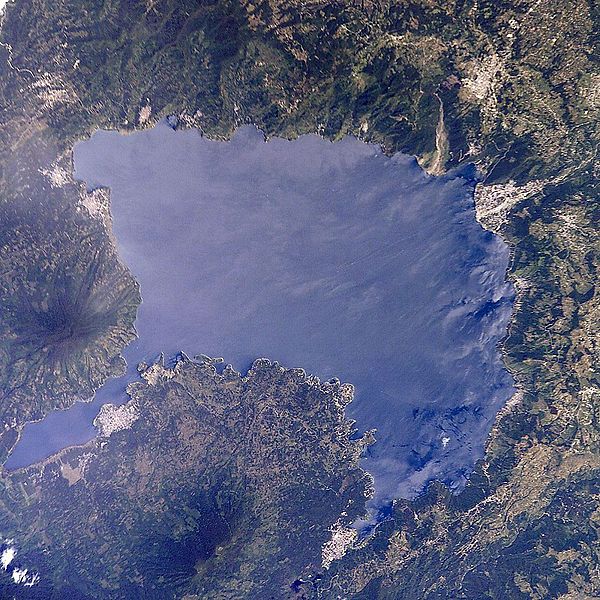
Lago de Atitlan Seen from the Space Shuttle.Lake Atitlan (Lago de Atitlan) is a large endorheic crater lake (one that does not flow to the sea) in the Guatemalan Highlands. Atitlan is recognized to be the deepest lake in Central America with maximum depth about 776 meters. The lake is shaped by deep escarpments which surround it and by three volcanoes on its southern flank. The lake is volcanic in origin, filling an enormous caldera formed in an eruption 90,000 years ago. The region first saw volcanic activity about 11 MA, and since then has seen four separate episodes of volcanic growth and caldera collapse, the most recent of which began about 1.8 MA and culminated in the formation of the present caldera. The lake now fills a large part of the caldera, reaching depths of up to 600 m. Some of the most shallow places in the lake are little more that one or two inches deep. The caldera-forming eruption is known as Los Chocoyos eruption, and ejected up to 300 km3 of tephra. The enormous eruption dispersed ash over an area of some 6 million km2: it has been detected from Florida to Ecuador, and can be used as a stratigraphic marker in both the Pacific and Atlantic oceans (known as Y-8 ash in marine deposits). A chocoyo is a type of bird which is often found nesting in the relatively soft ash layer.Since the end of Los Chocoyos, continuing volcanism has built three volcanoes in the caldera. Volcan Atitlan lies on the southern rim of the caldera, while Volcan San Pedro and Volcan Tolimбn lie within the caldera. San Pedro is the oldest of the three and seems to have stopped erupting about 40,000 years ago. Tolimбn began growing after San Pedro stopped erupting, and probably remains active, although it has not erupted in historic times. Atitlбn has grown almost entirely in the last 10,000 years, and remains active, with its most recent eruption having occurred in 1853. The earthquake fractured the lake bed causing subsurface drainage from the lake, allowing the water level to drop two meters within one month http://en.wikipedia.org/wiki/Lago_de_Atitl%C3%A1n |
San Pedro volcano, lake Atitlan |
lake Atitlan from san pedro volcano |
Lake Atitlan |
Lake Atitlan |
Cerro de Oro and San Pedro, 1858m |
Toliman, (behind it is Volcan Atitlan), 3158 m is a stratovolcano on the southern shores of Lago de Atitlan. The volcano was formed near the southern margin of the Pleistocene Atitlan III caldera. The top of the volcano has a shallow crater and its flanks are covered with the thick remains of ancient lavas flows that emerged from vents in the volcano''s flanks. A parasitic lava dome, known as Cerro de Oro, was formed on the volcano''s northern flank, which may have erupted a few thousand years ago. http://en.wikipedia.org/wiki/Volc%C3%A1n_Tolim%C3%A1n Toliman, 14.612 N, 91.189 W, 3158 m, stratovolcano. A lava flow that from the parasitic lava dome of Cerro de Oro entered Lake Atitlan during the last eruption at the volcano.Toliman has erupted viscous lava flows and domes, in contrast to adjacent Atitlan which has erupted dominantly pyroclastic materials.On 23rd April 2003 landslides buried on the volcano flanks.2002 Landslides. No recent eruptionshttp://www.volcanolive.com/guatemala.html |
Volcan Toliman was constructed within the Pleistocene Atitlan III caldera, near its inferred southern margin. A shallow elliptical crater truncates the summit, and a minor subsidiary peak to the SSW also has a shallow crater. In contrast to the tephra-covered surface of its twin volcano to the south, Volcan Atitlan, the surface of Toliman is draped by prominent thick lava flows. Many of the flows were erupted from vents on the volcano''s flanks and form a highly irregular shoreline on the south side of Lake Atitlan. No historical eruptions are known from Toliman. However, a lava flow that entered Lake Atitlбn from the parasitic lava dome of Cerro de Oro on the northern flank was considered by Newhall et al. (1987) to be less than a few thousand years old based on the thickness of sediment accumulated on the sublacustral part of the flow. http://www.authenticmaya.com/volcanoes.htm |
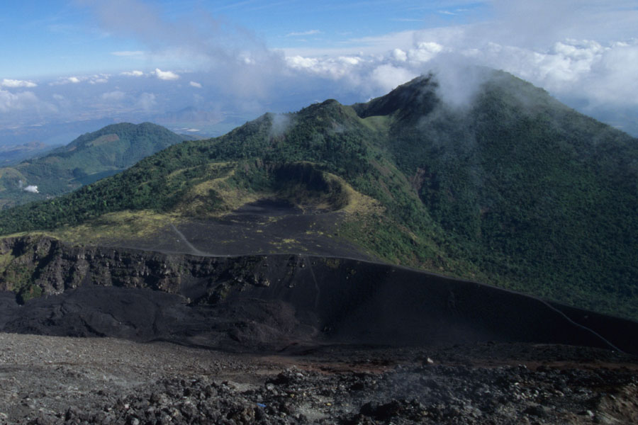
Volcan Toliman crater, (Laguna Seca or Plaza de Toros) http://www.authenticmaya.com/volcanoes.htm |
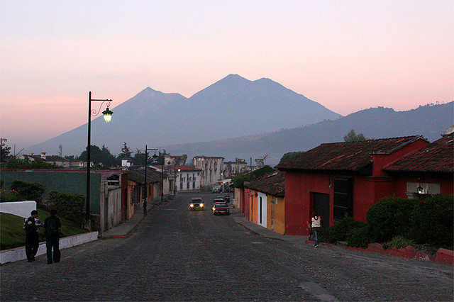
Fuego, Agua, Acatenango |
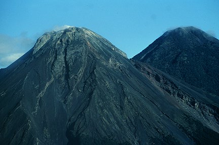
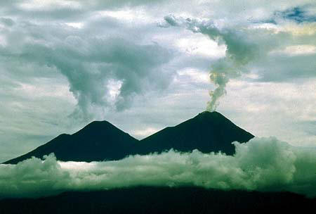
Fuego and Acatenango. Acatenango, 3946m, along with its twin volcano to the south, Volcan Fuego, Acatenango, which has two principal summits, was constructed during three eruptive periods post-dating the roughly 85,000-year-old Los Chocoyos tephra from Atitlбn caldera. An ancestral Acatenango volcano collapsed to the south sometime prior to 43,000 years ago, forming La Democracia debris-avalanche deposit, which covers a wide area of the Pacific coastal plain. Construction of Yepocapa, the northern summit of Acatenango, was completed about 20,000 years ago, after which growth of the southern and highest cone, Pico Central (also known as Pico Mayor), began. The first well-documented eruptions of Acatenango took place from 1924 to 1927, although earlier historical eruptions may have occurred. Francisco Vasquez, writing in 1690, noted that in 1661 a volcano that lay aside of Fuego a smoking mouth and still gives off smoke from another three, but without noise. http://www.authenticmaya.com/volcanoes.htm |
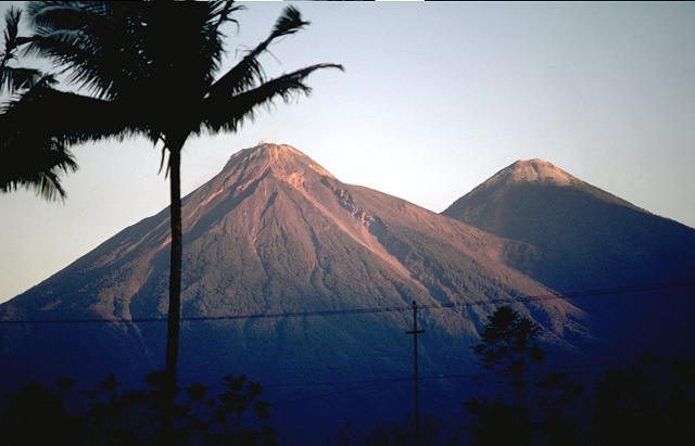
Fuego and Acatenango Volcanoes, Fuego, 3763m, one of Central America''s most active volcanoes, is one of three large stratovolcanoes overlooking Guatemala''s former capital, Antigua. The scarp of an older edifice, Meseta, lies between 3763-m-high Fuego and its twin volcano to the north, Acatenango. Construction of Meseta volcano dates back to about 230,000 years and continued until the late Pleistocene or early Holocene. Collapse of Meseta volcano may have produced the massive Escuintla debris-avalanche deposit, which extends about 50 km onto the Pacific coastal plain. Growth of the modern Fuego volcano followed, continuing the southward migration of volcanism that began at Acatenango. In contrast to the mostly andesitic Acatenango volcano, eruptions at Fuego have become more mafic with time, and most historical activity has produced basaltic rocks. Frequent vigorous historical eruptions have been recorded at Fuego since the onset of the Spanish era in 1524, and have produced major ashfalls, along with occasional pyroclastic flows and lava flows. http://www.authenticmaya.com/volcanoes.htm Fuego volcano is located 13km W of Antigua, the former capital and touristic center of Guatemala. The volcano is frequently active, displaying explosive strombolian and vulcanian activity. This can be accompanied by lava flows and pyroclastic flows. Fuego forms part of a large volcanic complex which includes Yepocapa (3880m), Acatenango (3976m), Meseta (3600m) and Fuego (3763m). Yepocapa itself nests on the remains of Acatenango Antiguo. Whilst Fuego and Meseta share a common magma source, Acatenango and Yepocapa are fed by a distinct system and thus represent a distinct volcanic unit. Nevertheless, due to their geographic proximity, both are dealt with together here.The structure of the Fuego-Acatenango Massif was shaped not only by progressive dome growth but also by at least two catastrophic failures of different parts of the edifice. It is thought that construction of the massif began about 230000 years ago with effusive activity around the site of the Meseta vent. Activity at Meseta is thought to have terminated after a large portion of its edifice collapsed leading to the Escuintla debris avalanche. Around 9 cubic km of material appear to have been mobilized with a runout distance of 27km to the SSE. Following this event it is thought that the Meseta conduit became plugged and that magma from the same underlying system migrated to a new vent underlying present day Fuego volcano. Primarily effusive activity at Acatenango Antiguo occurred over a period starting no earlier than 85000 years ago and is thought to have terminated about 43000 years ago following a large debris avalanche (La Democracia deposit). Between then and about 5000 years ago, Yepocapa cone has been growing on its remains. Pico Mayor de Acatenango (or simply Acatenango) started to grow about 20000 years ago. http://www.photovolcanica.com/VolcanoInfo/Fuego/Fuego.html |
Acatenango''s first historic eruption was in 1924. Two other eruptions occurred in 1924-1927 and 1972. Geologists visited the summit in 1981 and report the strong smell of sulfur but no visible fumaroles. Acatenango is one of the highest stratovolcanoes in central America.Acatenango, 14.50 N, 90.87 W , summit elevation 3976 m, stratovolcano. The volcano has two peaks, Pico Mayor and Yepocapa.During the 20th century, phreatic explosions ejected bombs which fell near the summit craters and ash fell up to 25 km away.1972 Eruption Three vents erupted in the saddle between the two peaks of Acatenago (Pico Mayor and Yepocapa).1926-27 Eruption Explosive eruptions occurred at Pico Central.1924-25 Eruption An explosive fissure eruption occurred on the North slope of Pico Central.Explosive eruptions at Acatenango occurred 1900 years ago (Pico Mayor), 2300 years ago (Pico Mayor) and about 5000 years ago (Yepocapa). Pyroclastic flows occurred at Acatenango volcano about 2000 years ago. Runout distances of pyroclastic flows are up to 12 km from the the summit. Acatenango Volcano Eruptions 1972, 1926-27, 1924-25, 1450, 90 AD +/- 100, 260 BC +/- 75, 370 BC +/- 200, 2710 BC +/- 75 http://www.volcanolive.com/guatemala.html |
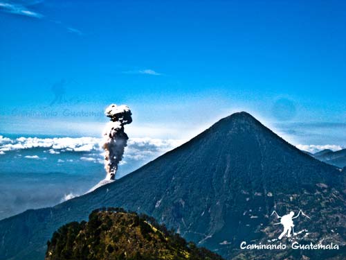
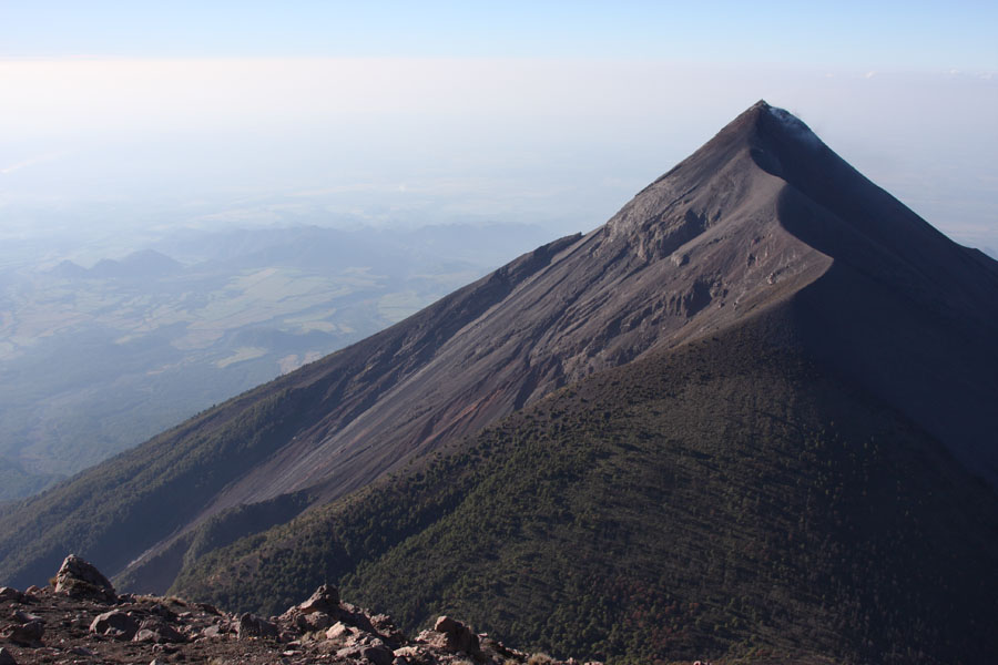
Fuego (erupting), Meseta, Acatenango (highest peak), Yepocapa (on right) |
Yepocapa summit viewed from flank of Acatenango. On right is crater from 1972 phreatic eruption -http://www.photovolcanica.com/VolcanoInfo/Fuego/Fuego.html |
Flank of Acatenango seen from Yepocapa. Note craters from 1924-1927 phreatic eruptions http://www.photovolcanica.com/VolcanoInfo/Fuego/Fuego.html |
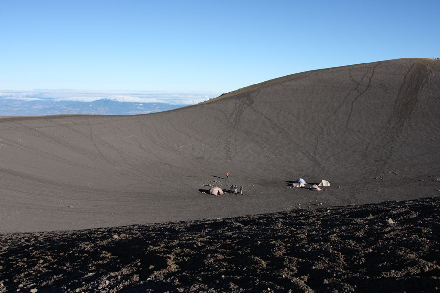
Summit of Acatenango volcano. Often used for camping but exposed during storms. Volcanism at Acatenango is primarily of an explosive andesitic type. Eruptions about 1900 years ago from Pico Mayor and 5000 years ago from Yepocapa produced widespread ash and pyroclastic flow deposits. However, since then only minor explosive phreatic activity has been documented at sites between the two summits in 1924-1927 and 1972. |
Summit and E flank of Fuego with forest-covered Meseta in foreground http://www.photovolcanica.com/VolcanoInfo/Fuego/Fuego.html |
Acatenango, last eruption 1972, is a stratovolcano , has two peaks, Pico Mayor (Highest Peak) and Yepocapa (3,880 m) which is also known as Tres Hermanas (Three Sisters). Acatenango is joined with Volcan de Fuego and collectively the volcano complex is known as La Horqueta. The Fuego-Acatenango massif comprises a string of five or more volcanic vents along a north-south trend that is perpendicular to that of the Central American Volcanic Arc in Guatemala. From north to south, known centers of volcanism are Ancient Acatenango, Yepocapa, Pico Mayor de Acatenango, Meseta, and Fuego. Volcanism along the trend stretches back more than 200,000 years. Although many of the centers have been active contemporaneously, there is a general sequence of younger volcanism, from north to south along the trend.This massive volcano complex towers more than 3,500 m above the Pacific coastal plain to the south and 2,000 m above the Guatemalan Highlands to the north. The volcano complex comprises remnants of multiple eruptive centers, which periodically have collapsed to form huge debris avalanches. The largest of these avalanches extended more than 50 kilometres from its source and covered more than 300 km2. The only known historical eruptions of Acatenango volcano occurred in the 20th century, between 1924 and 1927 from just north of the summit peak (Pico Mayor) and again in December 1972 from the saddle between Yepocapa and Pico Mayor. These phreatic explosions generated ballistic volcanic bombs that fell near the summit craters and fine volcanic ash that fell up to 25 km away.In prehistoric time, Acatenango has erupted explosively to form widespread fall deposits, hot pyroclastic flows and lava flows. There have been numerous eruptions during the past 80,000 years from vents along the massif. The most recent explosive eruptions of Acatenango occurred 1,900 years ago (Pico Mayor), 2,300 years ago (Pico Mayor) and about 5,000 years ago (Yepocapa). If such eruptions were to recur, many people and costly infrastructure would be at risk.The volcano has potential to produce huge debris avalanches that could inundate large areas of the Pacific coastal plain. http://en.wikipedia.org/wiki/Acatenango |
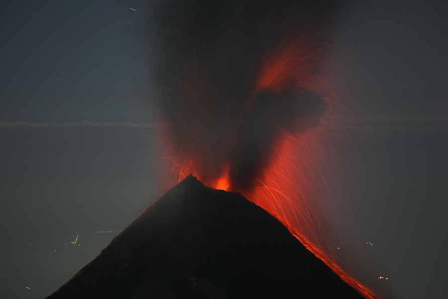
Fuego ash eruption animation, Dec. 2007 -http://www.photovolcanica.com/VolcanoInfo/Fuego/Fuego.html More than 60 eruptions have been documented from Fuego since 1524. Most were short-lived vulcanian explosive eruptions accompanied by ashfall, pyroclastic flows and later lahars. About 25% of these eruptions are reported to have involved lava flows. Clusters of historic eruptions lasting 20-70 years, seperated by relatively quiet periods of 80-170 years have been defined (Chesner and Rose (1984) J. Volc. Geotherm. Res. 21, p.25-44). These may coincide with the arrival of batches of magma into the shallow magma chamber from a far deeper source. The last "major" eruption occurred in 1974 when 0.1 cubic km of magma was erupted in essentially 4 main bursts. On 14, 17, 15 and 23 October, a series of powerful blasts produced up to 10km high ash columns and pyroclastic flows in 6 drainages to the E, W and SW. The longest flows reached over 10km from the summit but were fortunately restrained in uninhabited valleys. A 30cm layer of ash was deposited 10km to the W by the first burst, the second was even more powerful. Many thousands temporarily abandoned their homes due to the eruption. Roofs collapsed under the weight of the ash and crops and grazing areas were destroyed over a wide area extending up to 100km downwind. Many who initially stayed to sweep their roofs left after larger ballistics fell (10cm long ballistics were thrown over 5km from the crater).incandescence can often be observed in the base of eruption columns. The eruption photos in the present report were taken in Dec. 07 and Jan. 08 and reflect a period of sporadic yet slightly above average activity. Unusually harsh weather conditions unfortunately hampered observation somewhat. http://www.photovolcanica.com/VolcanoInfo/Fuego/Fuego.html |
De Fuego, 1974 eruption. Fuego, sierra Madre range, stratovolcano, last eruption 2012, is famous for being almost constantly active at a low level. Smoke issues from its top daily, but larger eruptions are rare. On August 9, 2007 Fuego erupted spewing lava, rock and ash. Guatemala''s volcanology service reported that seven families were evacuated from their homes near the volcano. The volcano is joined with Acatenango and collectively the complex is known as La Horqueta. A new round of activity began on 19 May 2012, with lava flows and ejections of ash.On September 13, 2012, the volcano once again began spewing lava and ash,. It spewed lava and pyroclastic flows about 600 m down the slope of the volcano http://en.wikipedia.org/wiki/Volc%C3%A1n_de_Fuego Fuego. Eruptions have produced ashfall, pyroclastic flows and lava flows. The crater of Fuego, has changed its appearance many times, since the eruption of 1932. Historic eruptions at Fuego volcano have been mostly basaltic in composition, but have become more mafic with time. This is proposed to be due to changing conditions of the parental magma chamber. Lahars, ejection of blocks and bombs. Fall of cinders and ash. The explosive phase 2012 of the eruption was preceded by emission of a 100 m long lava flow down the flank. The 1974 eruption was the largest since 1932. Magma was inferred to have risen into a dike-like conduit from a deeper magma body as a result of tidal influences. The eruption began on 10th October with ash eruptions and from a central crater. On 14th October ash clouds rose to 11 km above the summit. Nuees ardentes descending the Quebranda San Jose were visible from Finca Capetillo in Alotenango, 8 km ENE of the crater. Pyroclastic flows with velocities of 75 km per hour reached 7 km from the crater. Eruptions 2002-12, 2000, 1999, 1987, 1977-79, 1977, 1975, 1974, 1973, 1971, 1967, 1966, 1963, 1962, 1957, 1955, 1953, 1949, 1947, 1944, 1932, 1896, 1880, 1867?, 1861?, 1860, 1857, 1857, 1856, 1855, 1852?, 1850?, 1829, 1826, 1799, 1773?, 1765?, 1751?, 1737, 1732, 1730, 1717, 1710, 1709?, 1706, 1705, 1702, 1699, 1689?, 1686, 1685, 1679?, 1629-32, 1623, 1620, 1617, 1614, 1587, 1586, 1585, 1581-82, 1577?, 1576?, 1575?, 1571?, 1565?, 1559?, 1557?, 1551-52, 1542, 1541, 1531, 1526?, 1524 http://www.volcanolive.com/guatemala.html |
Fuego |
Nighttime strombolian eruption of Fuego.Daytime ash-rich strombolian eruption from Fuego, Dec. 2007http://www.photovolcanica.com/VolcanoInfo/Fuego/Fuego.html |
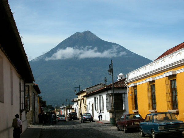
Volcan de Agua (right) and Fuego (left).Volcan de Agua, 3760m, holocene, is a stratovolcano. It has been inactive since the mid 16th century. At 3,760 m, Agua Volcano towers more than 3,500 m above the Pacific coastal plain to the south and 2,000 m above the Guatemalan highlands to the north. It dominates the local landscape except when hidden by cloud cover. As the lahar produced a destructive flood of water, this prompted the modern name "Volcano of Water", in contrast to the nearby "Volcan de Fuego" or "Volcano of Fire". Though the volcano has not been active since the mid 16th century, it has the potential to produce debris flows and lahars that could inundate nearby populated areas.The volcano was last blanketed by snowfall in January 1967. http://en.wikipedia.org/wiki/Volc%C3%A1n_de_Agua |
Volcan de de Agua. The symmetrical, forested Volcan de Agua stratovolcano The 3760-m-high basaltic-andesite to andesite Agua volcano has an isolated position that makes it a prominent landmark from all directions. A small, 280-m-wide circular crater is breached on the NNE side. Six small pit craters are located on the NW flank, and two small cones lie on the south flank. Agua''s symmetrical profile implies a relatively young age, although currently no dated Holocene tephra deposits are known. Agua has had no historical eruptions, but its name (the water volcano) originates from a devastating mudflow on September 11, 1541. http://www.authenticmaya.com/volcanoes.htm Agua 14.465 N, 90.743 W , summit elevation 3760 m , stratovolcano. The volcano contains six small pit craters on the NW flank. The summit contains a circular, 250 m diameter crater, which is breached towards the NNE. The crater walls are vegetated. No historical eruptions have occurred at the volcano. 1541 Lahar, debris flow at Agua was similar to the 1998 debris flow at Casita volcano, during hurricane Mitch.Eruptions of Agua volcano. Agua has erupted explosively in the past 80,000 years, creating widespread ash-fall deposits, pyroclastic flows and lava flows. The most recent eruptions are more than 10,000 years ago.http://www.volcanolive.com/guatemala.html |
Agua from the Pacaya the Toliman and Atitlan, in the back |
Lake Amatitlan is a volcanic lake ,crater lake. It lies in the central highlands, 1,186 m above sea level. Its maximum depth is 33 m and an average of 18 m . The lake is 11 km long and 3 km wide; with an area of 15.2 km2 and a water volume of 0.286 km3. |
Pacaya Volcano 2007. In background from right to left: Agua, Acatenango and Fuego volcanoes -http://www.photovolcanica.com/VolcanoInfo/Pacaya/Pacaya.html |
Mild strombolian activity from active summit crater of Pacaya, Dec. 2007 Agua volcano in background at top left. |
The lava flowing out of the active Pacaya Volcano.On May 27-28, 2010, powerful activity from a new vent south of the summit of Pacaya resulted in heavy ashfall in Guatemala City causing closure of the International Airport. Volcanic bombs and lapilli hailed down on surrounding communities (several of which were evacuated), causing the death a local journalist. In the days following this violent explosive episode, a nearly 100m wide lava flow was emitted from a vent about 1.5 km south of the new crater and progressed over 3 kilometers, cutting roads and burying several properties, such as large parts of Finca El Chupadero including the pineapple plantation and animal housings (resulting in some livestock loss). http://www.photovolcanica.com/VolcanoInfo/Pacaya/Pacaya.html |
Pacaya Volcano |
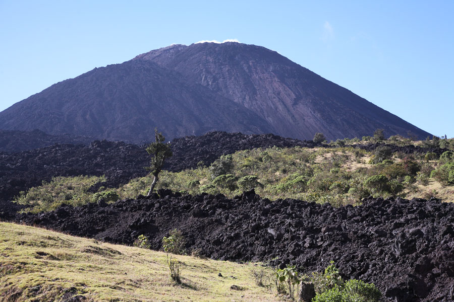
Pacaya Volcano 14.38 N, 90.60 W , summit elevation 2552 m , complex volcano. Activity at the volcano consists of strombolian eruptions, ash eruptions, and lava flows. caldera forming eruption at Pacaya occurred 23,000 years ago. The volcanic complex contains three old summits: Cerro Chino (2260 m), Cerro Chiquito (2460 m) and Cerro Grande (2560 m). Two lavas (basaltic andesite and dacite), coexist at Cerro Chiquito dome.Between 1961 and 2000 Strombolian activity persisted at Pacaya volcano, with two to three paroxysmal eruptions each year. http://www.volcanolive.com/pacaya.html |
Cone with fumarolic deposits on summit of Pacaya, 2005. Whilst activity at Pacaya usually has limited impact on the surrounding communities on the flanks of the volcano, a repeat of the flank collapse event would today have catastrophic consequences. Small collapses of the summit of MacKenney cone have been witnessed in 1993 and 1995, leading to a 3.5km hot avalanche and a similar smaller event burning vegetation and damaging a radio station on Cerro Chino, respectively. Further, as the size of MacKenney cone increases, eruptions from the cone will be less constrained by the walls of the collapse depression which until 2006 prevented lava flows extending beyond its perimeter. This increases the risk of hot avalanches, pyroclastic flows and lava flows to the communities on the N flank of the volcano. Also, reactivation of the Cerro Chino crater (last active 1846) would present a risk to these communities. This forest-covered crater is usually passed unnoticed when climbing from San Francisco and is located outside the NW perimeter of the collapse depression. Presently, the most common risk to these communities is the impact of ballistics from larger explosive eruptions. In 1986, for example, 250g ballistics damaged roofs and killed livestock in Calderas (3km from MacKenney cone). In 1989 and 1991, over 1m diammeter blocks were thrown over a km from the crater and smaller blocks were distributed over a wide area. The same happened in 1998 in an eruption which lead to closure of the Airport of Guatemala City due to ashfall. The airport was in fact closed twice that year due to ashfall and again in 2000. The amount of ash involved was minimal, yet it can have a severe impact on aircraft engines and hence even a mm of ash can lead to airport closure (this is a common occurrence at Catania airport during eruptions of Etna volcano). Luckily, larger eruptions are often preceeded by increases in seismicity so that surrounding communities can be warned. Further, visible increases in fumarolic activity have sometimes been reported in the minutes leading up to larger explosions. Large explosive eruptions often involve episodes of intense lava fountaining. Up to 800m high lava fountains were observed on 16 Jan 2000 and less high fountains have been observed on several previous occasions. http://www.photovolcanica.com/VolcanoInfo/Pacaya/Pacaya.html |
Pacaya Volcano 2010 Eruptions Pacaya volcano, Guatemala erupted on 28th May 2010. Guatemala''s President declared a state of "calamity" in two provinces and opened emergency shelters to accommodate over 1,700 residents who were evacuated. More than 65 people were injured, some people are missing, and hundreds of houses damaged by the eruption which sent stones and ash over a wide area. The international airport at Guatemala City remained closed for 20 hours. The runway was covered by 2.5 cm of volcanic ash. In February 2010 lava flows from Pacaya volcano descended 100-400 m down the E and NE flanks.2008 Eruptions Multiple lava flows, up to 300 m long, were visible at the volcano on 20th November 2008. 2005 Lava Flows During January-March 2005 a new phase of activity developed at Pacaya, where the active cone emitted small amounts of lava. During March-April 2005 cracks opened on the MacKenney crater. In April 2005 an 800 m long lava flow effused from fissures on the cone''s ENE side. 2000-2002 Lava Lake From August 2000 to June 2001 a lava lake was present in the crater, and a glow and was often visible from Guatemala city. 2000 Paroxysmal Eruptions Eruptive pattern changed in the year 2000. Paroxysmal eruptions occurred in January 2000, and 29th February 2000. Lava fountains began at Pacaya volcano at 1615 hr on 16th January 2000. The fountains reached a maximum height of 800 m. This was the largest eruptions at the volcano since the current eruptive cycle began in 1961. Fallout from the lava fountain produced nearly constant nuйes ardentes and a lava flow that extended 600-700 m to the SW. Strombolian activity returned around 2030 hr. A second large eruption began at Pacaya volcano at 1815 on 29th February 2000. A lava fountain reach a height of 700 m above the summit. 1999 Eruptions and aircraft damage On 21st May 1999 at least two commercial aircraft flew into ash clouds from Pacaya volcano near Guatemala city. Both aircraft were seriously damaged, but managed to land safely. One aircraft required engines to be replaced, at a cost of $2 million each. 1989 Eruptions Explosive eruptions occurred at Pacaya volcano between 7-10 March 1989. Ashfall was reported on the south coast of Guatemala 50 km from the volcano. On the afternoon of 7th March an incandescent column of tephra rose 2000 m above the crater. Blocks were ejected 3000 m high. Ash fell at Cerro Grande, El Chipilinar, San Carlos, and Santa Elena Barillas, 7 km NE of the crater. Bombs and blocks up to 1.5 m in diameter fell in the La Meseta area 1.5 km north of the vent. On 8th March strong eruptions produced a 3000 m high plume. On 9th March ashfall occurred on the Guatemala-El Salvador border, 80 km from Pacaya volcano. 1988 Eruptions Strombolian eruptions and lava flows occurred at Pacaya volcano in 1988. Explosions increased from a few hundred per day in early June to about 2,000 per day in mid-June, and reached a maximum of 3,300 on 5th October. 1987 Eruptions and Injuries At the end of January 1987 eruptions at Pacaya volcano destroyed 63 homes and caused the evacuation of 3000 people. On 21st January at 1520 hr eruptions of Pacaya volcano injured 12 people at Calderas 3 km north of the volcano, when 25 cm blocks landed in the town. Ash fell at Chiquimula, 180 km ENE of Pacaya. The eruptions formed a new 160 m diameter crater within MacKenney Cone. On 25th January another explosion occurred at Pacaya volcano. An eruption column reached 8 km high. Houses in El Caracol (3 km SW), El Patrocinio (3.5 km W), and Los Pocitos (6 km SSE) were hit by 25 cm blocks. On person was admitted to hospital and many livestock were killed. A strong explosopn occurred on 14th June 1987. A column of ash, cinders, and lapilli were ejected 500 m above the summit. Cinder fell 100 km south of Pacaya, and the town of El Caracol (3 km SW) was evacuated. 1986 Eruptions On 19th January a small lava dome had formed at the western base of MacKenney Crater. 1985 Eruptions On 10th February a lava flow was observed moving NNE of MacKenney Crater. At the end of February, two vents were active inside the crater. Small strombolian explosions were observed at Pacaya volcano on 24th April, ejecting lava 20 m high about every 7 minutes. An active lava flow on the western flank of Pacaya volcano was observed by farmers, but not visited by scientists. 1984 Eruptions Strong explosions were hear by residents near Pacaya volcano on 15th May 1984. The explosions destroyed half the active cone. Strombolian eruptions were occurring on 5th August. 1983 Eruptions Strombolian explosions began at MacKenney Crater, Pacaya volcano in March 1983. On 17th July activity was seen and heard from nearby towns. On 16th November the active cone on the southern edge of MacKenney Crater, had grown to over 100 m high. Aa lava flowed from below the base of the active cone, and traveled down the north-west flank. 1982 Eruptions Observations at Pacaya volcano on 12th February 1982 showed lava flowing several kilometers down the SSW flank, originating from a hornito at 2,100 m altitude on the SW flank. Lava continued to flow from the hornito as of 4th March 1982.1981 Eruptions Pacaya volcano showed Strombolian activity on 14th February 1981, for the first time since 1975. Explosions reached a height of 200 m above the crater at an interval of 10 seconds to 1 minute. The northern half of the crater floor was filled with pahoehoe lava. Eruptions rached a peak on 18th February at 1730 hr when lava overflowed the north rim of the crater and traveled down Pacaya''s north flank. By 5th March the lava lake inside MacKenney Crater was at a higher level. Three vents in MacKenney Crater were aligned in a north-south direction.1980 eruptions A small cincer cone formed inside MacKenney Crater at the end of 1987.1977 Eruptions Ash emissions occurred from MacKenney Crater on 19, 20 and 27 August 1977. A strong smell of sulphur was reported at the volcano. 1976 Eruptions Ash eruptions occurred at Pacaya volcano one day before an earthquake hit the area. The 4th February earthquake was immediately followed by black steam emission from MacKenney Crate.1975 Eruption A lava flow occurred at Pacaya in September 1975.1973 Eruptions Renewed ash eruptions occurred at Pacaya volcano on 13th January 1973. Lava flowed from a flank on the SW flank of the volcano.1972 Eruptions A lava flow began on 2nd February from Cerro Chino cone. The lava extended 1.5 km in 2 days in a westerly direction. Ash emissions accompanied the lava flow. New ash emissions occurred from MacKenney Cone about 15th October 1972, accompanied by enlargement of the crater. 1970 Eruptions Strong eruptions occurred on 8th January 1970.1969 Eruptions Eruptions occurred at Pacaya in December 1969 with scoria emission from MacKenney Cone. 1775 Eruptions Eruption of Pacaya volcano in 1775 produced tephra which reached Antigua 35 km NW. A lava flow extended 6 km SW from a vent on Cerro Chino cone.1961-2011, 1885, 1846, 1830?, 1805, 1775, 1760?, 1717?, 1699, 1693, 1690, 1687,1678, 1677?, 1674, 1671, 1668-69, 1664, 1655, 1651, 1623?, 1565. http://www.volcanolive.com/pacaya.html |
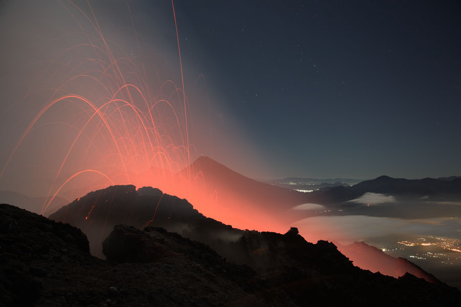
Eruptions often include simultaneous explosive activity and lava effusion. A time-exposure view of Pacaya volcano in Guatemala in 1988 shows the incandescent traces of lava bombs explosively ejected from the summit crater and the profile of a lava flow descending from a vent on the right-hand flank of the volcano. Pacaya is an example of a volcano that has displayed more-or-less continuous eruptive activity for long periods of time. Long-term explosive and effusive eruptions began at Pacaya in 1965 and have continued since. Eruptions are often visible from Guatemala City, 40 km to the north http://photo2.si.edu/earthquakes/pacaya.htmlPhoto |
Pacaya current eruption (May 2006)http://www.authenticmaya.com/volcanoes.htm |
The Volcan de Pacaya massif rises above skyscrapers of the capital city of Guatemala, located only 30 km to the north. The rounded, forested lava dome of Cerro Grande forms the 2560 m high point at the left. The twin peak at the right is the historically active vent of Pacaya, with the right-hand summit being MacKenney cone, which has been active since 1965. The modern cone was constructed within an arcuate caldera whose rim forms the ridge on either side. Eruptions of Pacaya are often visible from Guatemala City http://www.authenticmaya.com/volcanoes.htm |
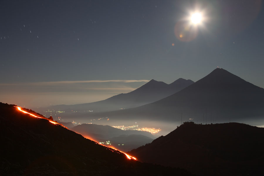
Nighttime view of Pacaya''s MacKenney Cone. Summit incandescence and lava flows from shield on flank are visible. Dec. 2007 |
http://www.skyscrapercity.com/showthread.php?t=892280&page=2 |
MacKenney Cone in 2007, new lava shield has formed on left flank and lava flows have reached trail during 2006 -07. Pacaya Volcano (2560m) is located 30km south of Guatemala City center and directly south of the large lake-filled Amatitlan Caldera. From 1965-1975 and since 1990, Pacaya has almost permanently been in eruption, displaying primarily strombolian activity together with the extrusion of aa lava flows from summit or flank regions of MacKenney cone. Occasionally, larger explosive eruptions have been witnessed which shall be discussed later. MacKenney cone has formed in the horseshoe-shaped depression left by collapse of over half a cubic km of the W-SW sector of the volcanic edifice around 1100 years ago. This sector collapse produced a 25km long avalanche deposit extending onto the pacific coastal plane. Lava flows from MacKenney cone finally overflowed the E-NE wall of the depression in 2006 and have covered the old trail to the cone, making access more difficult http://www.photovolcanica.com/VolcanoInfo/Pacaya/Pacaya.html |
Cerro Grande lava dome in 2005. Flank of collapse scar is still evident in foreground. Since the sector collapse exposed an up to 200m thick cross-section of the previous structure, it has been possible to paleomagnetically date the most recent deposits of pre-collapse Pacaya. This revealed that activity of Pacaya in the last couple of thousand years has been strongly episodic, involving emplacement of thick deposits of basaltic lava over periods of under 300 years in length followed by inactive phases lasting from 300-500 years (Conway et al., Bull. Volc. 55(1-2), p.25-32 (1992)). Looking further back into the history of Pacaya one sees 3 further distinct phases in its construction (Bardintzeff and Deniel, Bull. Volc. 54(4), p.267-283 (1992)). Little remains visible of the Phase I structure which is largely eroded or buried. Phase II was largely effusive and resulted in the emplacement of a large cone structure around 500000 years ago. Phase III was a largely extrusive phase, resulting in emplacement of several andesito-dacitic lava domes approx. 160000 years ago. This include Cerro Grande, the second highest structure in the complex. Phase II and IV (present) lavas are chemically similar and may have also been partially mixed into the Phase III lavas by some form of connection between the basaltic and dacitic magma chambers. http://www.photovolcanica.com/VolcanoInfo/Pacaya/Pacaya.html |
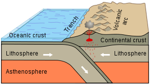
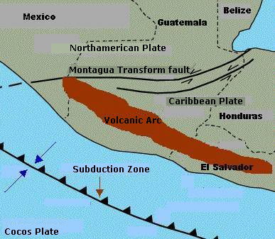
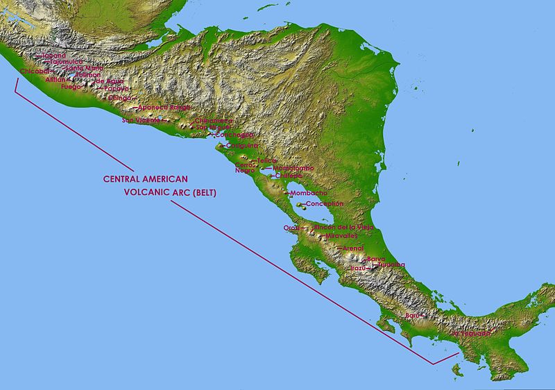
The Central America Volcanic Arc is a chain of volcanoes which extends parallel to the Pacific coast line of the Central American Isthmus, from Guatemala, El Salvador, Honduras, Nicaragua, Costa Rica and down to northern Panama. This volcanic arc, which has a length of 1500 km, is formed by an active subduction zone along the western boundary of the Caribbean Plate.
The Central America Volcanic Arc includes hundreds of volcanic formations, ranging from major stratovolcanoes, to lava domes and cinder cones. Some of these have produced large explosive eruptions, like the colossal VEI 6 eruption of the Santa Maria volcano in 1902. Central America''s highest volcanoes are found in Guatemala and include the Tajumulco and Tacana, both above 4,000 meters. Several volcanoes in Central America are currently active, including Arenal, Turrialba, Irazu, Poas in Costa Rica; Cerro Negro, San Cristobal, Concepcion in Nicaragua; San Miguel, Santa Ana, Izalco in El Salvador; Santa Maria/Santiaguito, Pacaya, Fuego in Guatemala
in the Mexico/Guatemala border: Tacana; in Guatemala: Tajumulco, Santa Maria, Chicabal, Toliman, Atitlan, Volcan de Fuego, Volcan de Agua, Pacaya, Chingo; in El Salvador: Apaneca Range, San Vicente, San Miguel, Chinameca and Conchagua; in Nicaragua: Cosiguina, Telica, Cerro Negro, Momotombo, Chiltepe, Mombacho and Concepcin; in Costa Rica: Orosa;, Rincon de la Vieja, Miravalles, Arenal, Barva, Turrialba and Irazu; in Panama: Baru an La Yeduada
http://en.wikipedia.org/wiki/Central_America_Volcanic_Arc
http://en.wikipedia.org/wiki/List_of_volcanoes_in_Guatemala
Eruptive history at Santa Maria is thought to have begun 30000 years ago, resulting in gradual construction of a 3772m high stratovolcano. Before 1902, the volcano had been in a long period of quiescence and no records of activity existed. In 1902-1903 a large number of earthquakes shook central america. On January 1902, a major quake hit the area around Santa Maria, followed on April 19 by a quake reaching 8.3 on the Richter scale centered at Santa Maria, which destroyed much of the nearby city of Quetzaltenango. On September 23, a similarly powerful quake centered 210km NW of Santa Maria was recorded. In the period running up to the eruption, an average of over 40 earthquakes was being recorded every month in the region.
On the afternoon of 24 October 1902, rumbling noises were heard at the foot of Santa Maria and eruptions of steam and ash were observed at the SW flank. As night fell, a large ash cloud was already rising from the volcano. Based on accounts of the type of volcanic rocks raining down on the surrounding areas, it is assumed that the Plinian phase of the eruption commenced at around 1:00 on the 25th of October. The eruption continued to gather strength and was accompanied by violent seismic activity peaking at 3:00, 7:30 and 11:00. (Note: information about eruption mainly from Williams and Self, 1983 (Journal of Volcanology and Geothermal Research 16:33-56)). The Plinian phase of the eruption lasted for nearly 20 hours and deposited a 30m thick layer of ash and pumice near the volcano. Deposits over 1m thick were found up to 30km downwind (to the NW), and an area of 270 thousand square kilometers received at least 1mm of ash. The ash and pumice forms a single fall unit, suggesting that the eruption was driven by a nearly continuous gas blast. The intensity of the blast appears to have increased gradually, until the Plinian phase of the eruption abruptly stopped after 20 hours. A reliable calculation of the column height was made with the aid of a sextant by the captain of the SS Newport which was sailing nearby. A height of 28km was obtained. Other sources suggested a height of up to 48km. Calculations based on the total amount of material erupted (8.6 cubic km of dense rock equivalent) and on the duration of the eruption, provide an estimated average height of 35km (Williams and Self, 1983). Detonations could be heard as far away as Costa Rica, 850km to the SE. The eruption was one of the largest five in the last 200 years and tore a 0.5 square kilometer crater in the SW flank of the previously symmetrical Santa Maria cone.
As for the volcano, after further milder ash eruptions on the following days, it appears that the eruption stopped by the 29th of October. Minor eruptive activity was reported sporadically until 1913. The abrupt end of the Plinian eruption phase is interesting since the end of such eruptions is usually preceeded by a reduction in eruption intensity (in many cases causing lethal column collapses). It is suggested that the conduit may have been blocked by a collapse of its walls before the magma chamber had been exhausted (the chamber is thought to lie very deep as no caldera was formed inspite of the eruption of many cubic kilometers of material). This theory is supported by the observation that the Santiaguito dome is constructed from essentially the same magma as the 1902 pumice. Hence, the eruption of Santiaguito may even be regarded as the final phase of the 1902 eruption.
The onset of the construction of the santiaguito lava dome complex was marked in 1922 by observation of lava extrusion in the center of the 1902 crater. The complex today comprises 4 main structures known from East (S. Maria side) to West as Caliente, La Mitad, El Monje and El Brujo. From 1922-2000, 8 distinct cycles of high lava extrusion (lasting about 3-5 yrs) followed by low extrusion (10-12 yrs) have been distinguished (Harris et al., 2003 (Bulletin of Volcanology 65:77-89)). Extrusion in the first cycle (Caliente I (1922-1929)) was highest, reaching 2 cubic meters/sec. The following cycles were (2) Caliente II (1929-1939), (3) La Mitad (1939-1949), (4) El Monje (1949-1958), (5) El Brujo (1958-1972), (6) El Brujo & Caliente III (1972-1986), (7) Caliente IV (1986-1996) and (8) Caliente V (1996-?). During cycles 3-5, new domes were emplaced in an increasingly westward direction, further from the main vent which is assumed to lie under Caliente dome. This trend was reversed in the 6th cycle when both El Brujo and Caliente were active. The return of activity to Caliente has been accompanied by a decline in maximum extrusion rates since cycle 5 and may represent a decrease in the pressure driving the eruption and a resulting inability to maintain extrusion at lateral vents. Silica content and thus viscosity of lava erupted since 1970 has also been in steady decline and may reflect eruption of material from a deeper source, suggesting possible chamber exhaustion (Harris et al., 2003).
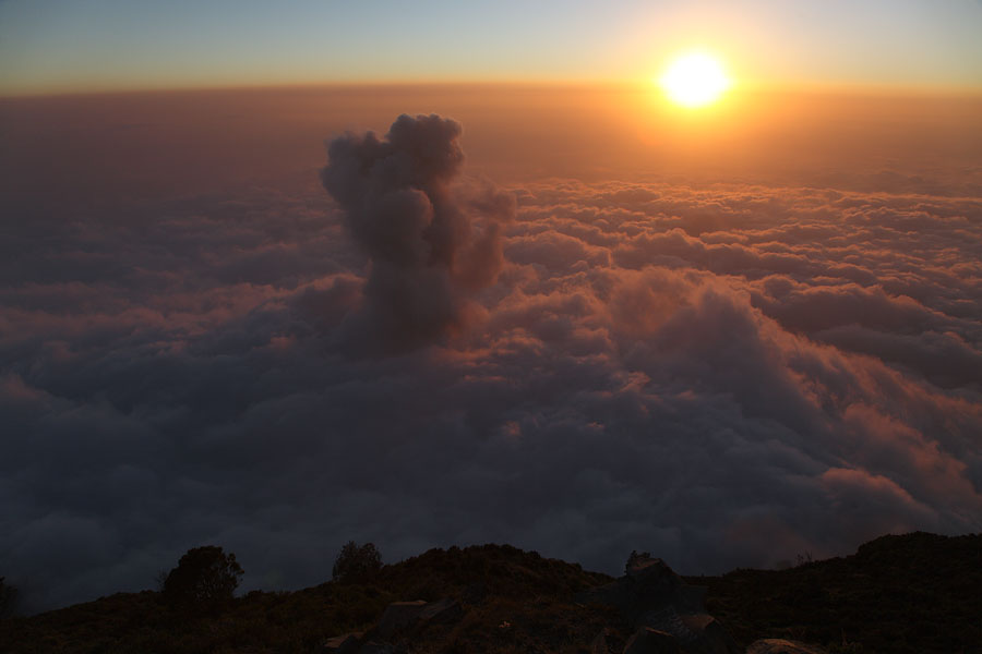
The cyclic activity has been punctuated by a number of interesting events which deserve mention at this point. From 2-4 Nov. 1929, hot clouds of blocks and ash (pyroclastic flows) extended up to 10km from Santiaguito killing many hundreds, if not thousands, of people. Large pyroclastic flows (PFs) were repeatedly witnessed in 1929-1934, after which this kind of activity died down. A violent eruption in 1973 caused a 4km long PF. A 5km PF was reported in 1989 in an eruption involving a lateral blast. This 19 July eruption marked the onset of a period of major unrest at Santiaguito. In 1990, multiple episodes of explosive activity involving lateral blasts and PFs with runout distances of up to 7km occurred. Sadly, on 19 July 1990, a lateral blast killed 4 hikers climbing on the E rim of Santa Marias 1902 crater 1km from the Caliente vent. Activity in recent years has been more subdued. However, on 26 April 2010, an 8 km high ash plume was produced by an unusually powerful event, with ashfall causing some disruption in several provinces downwind (to the NW). Whether this marks the onset of a new major eruption remains to be seen.
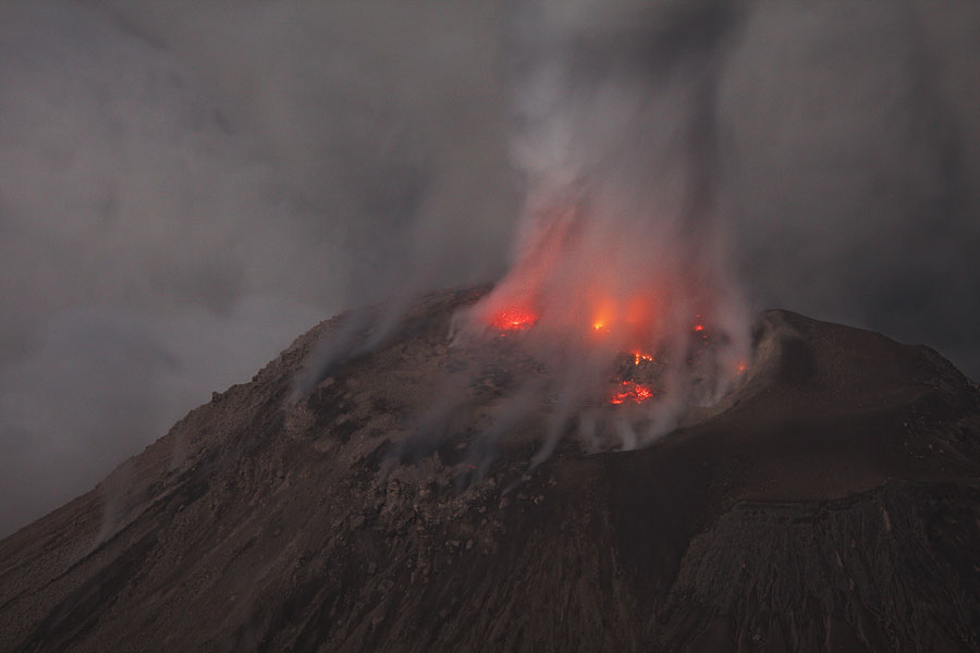
Since the summit of Santa Maria provides an ideal vantage point, it has been possible to observe the vent dynamics of Santiaguito in some detail. Two types of distinct activity were observed on the same days when the volcano was visited in 2005 and 2007. Firstly, emission of ash and incandescent fragments primarily from a single vent region accompanied by a loud aircraft-engine like noise which could last for several minutes. Secondly, explosive eruptions of ash and initially incandescent fragments from a ring-shaped fracture could occasionally be observed. This form of activity is discussed in Bluth and Rose 2004 (J. Volc. Geotherm. Res. 136, p.297-302) and is attributed to preferential production and accumulation of gases at the conduit boundaries. The images and animation below illustrate these different eruption types in detail
further interesting feature of the activity of Santiaguito has been the emplacement of a number of block lava flows. Due to the viscosity of the silica-rich dacite lava, these massive (in places over 30m thick) flows are gradually extruded and move slowly downhill over periods of months or even years. First major block flows were observed in cycle 5 (reaching up to 2300m from the dome), followed by up to 2150m and 3600m long flows in cycles 6 and 7, respectively. Collapses of the massive flow front can cause dangerous pyroclastic flows.
The summit of Santa Maria provides a birds-eye view of activity at Santiaguito. Alternatively, viewpoints exist to the North. Approach from the South is complicated by private fincas and numerous inpassable deep erosion gulleys. Climbing on El Brujo Dome is possible via a Northerly approach, but a guide is absolutely necessary to find the route. Clearly, this is dangerous and rarely offers better views than the other locations mentioned. Recently, even climbing onto the rim of active Caliente dome has been offered. http://www.photovolcanica.com/VolcanoInfo/Santiaguito/Santiaguito.html
Santa Maria, summit elevation 3772 m , stratovolcano. Santiaguito lava-dome complex has been growing at the base of the 1902 crater since 1922. On 3rd March 2011 an explosion occurred from Caliente crater at Santa Maria volcano in Guatemala. Ash emissions reached 10,800 ft above sea level and produced ashfall in towns to the west and southwest of the volcano. The explosion generated a pyroclastic flow which moved 2.5 km down the southwest flank. Activity continued on 4th March with moderate explosions ejecting ash to a height of 11,000 ft above sea level, and ash fall on surrounding farms. On 2nd January 2010 there was a collapse of the eastern part of the crater of Santiaguito, producing a pyroclastic flow which reached the base of the crater. On the 4th January there were three explosions which produced an ash column 200 m high. Eruption occurred at Santa Maria volcano on 26th and 29th June from Santiaguito lava dome. Ash plumes reached a height of 10,800 ft above sea level. Continued eruption occurred at Santa Maria volcano in 2008. Santiaguito dome continued to explode, creating ash plumes, and collapse, creating avalanches which descended the flanks. One of the largest eruptions of the 20th century occurred at Santa Maria Volcano in 1902. The eruption of Santa Maria occurred on October 24 to 26, 1902. Explosions were heard in Costa Rica 850 km south of the volcano. Sulphurous odours reached Coban, 160 km to the NE and shock waves rattled windows in the town. On 25th October a Captain from the mailboat S.S. Newport, off the Pacific coast, measured the column height at 27 to 29 km using the ship''s sextant. The eruption left a 700 x 1,000 m crater in the SW flank of Santa Maria Volcano. Growth of a dacite dome called Santiaguito began in this crater in 1922. The largest pyroclastic flow since 1922 took place in 1929 at Santa Maria Volcano. Almost continuous volcanic activity has occurred since 1922. Eruptions 1922-2011, 1903-13, 1902 http://www.volcanolive.com/guatemala.html
List of volcanos in Guatemala
next
CAVA
Central American Volcanoes
Caribbea plate