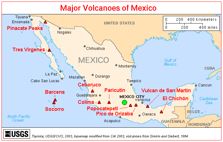
 | Volcanoes in Mexico. Baja California |
|
|
Baja California |
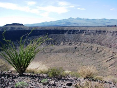
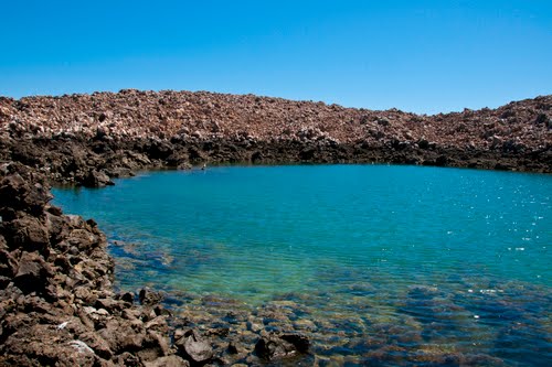
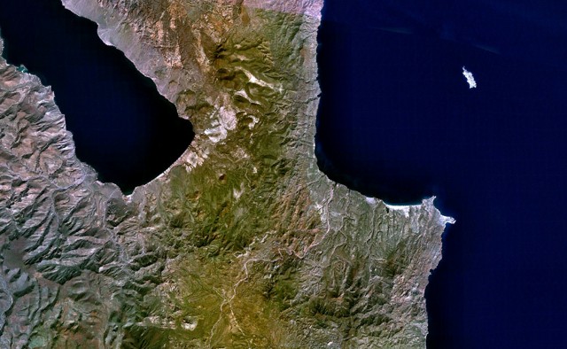
El Pinacate is a massive (50 kilometers/31 miles long), dormant shield volcano. The volcanic features you will find within the Reserve are 8 giant Maar craters, 1 tuff cone, and over 400 others like cinder cones and aЎЇa and pahoehoe lava flows. The lavas range in age from more than 1.7 million years to 1.1 million years ago and are overlain and flanked by younger cinder cones, lava flows, and craters.Pinacate volcano is a young volcanic field of maars, tuff rings, more than 500 basaltic cinder cones in the Sonoran desert in NW Mexico, a nearly unpopulated region between Arizona and the Gulf of California. The field covers an area of about 60 x 55 km and has been active less than 10,000 years ago. The Pinacate volcanic field contains the older, 1200-m-high Santa Clara basaltic-to-trachytic shield volcano. Younger eruptions produced more than 500 basaltic cinder cones and lava flows that blanket the slopes of Santa Clara and the surrounding desert.Among the principal features of the Pinacate volcanic field are Elegante crater, a 1.6-km-wide maar, and Cerro Colorado, a 110-m-high, 1.1-km-wide tuff ring. Typical eruption style: strombolian.No recent earthquakes http://www.volcanodiscovery.com/baja-california.html http://www.yourtravelchoice.org/2010/03/explore-one-of-mexicos-13-natural-wonders-with-cedo-naturarte-ecotours/ |
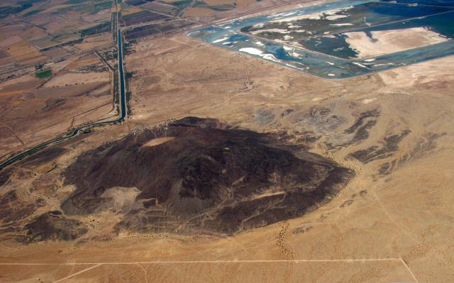
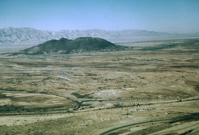
Aerial photograph of the northern Gulf of California showing Cerro Prieto volcano and adjacent geothermal field. In the upper right, note the evaporation ponds used for geothermal fluids. Picture courtesy of Axel Schmitt, pilot Mark Harrison.The Cerro Prieto geothermal field is located at the head of the Gulf of California, 35 km south of the city of Mexicali. Cerro Prieto lies in an active continental rift that is transitional between the transform San Andreas fault system to the north and a spreading ridge of the East Pacific Rise in the Gulf of California to the south. The only surficial volcanic feature at Cerro Prieto, which is located near sea level on the Colorado River delta, is a small, 223-m-high compound dacitic lava dome. A 200-m-wide crater is located at the summit of the NE-most dome. The Cerro Prieto dome was roughly estimated from paleomagnetic evidence to have formed during a series of events between 100,000 and 10,000 years ago. Cucupas Indian legends described a monster that covered the land with hot rocks, which grew through the soil and emitted fire tongues, a possible reference to the growth of the volcano. |
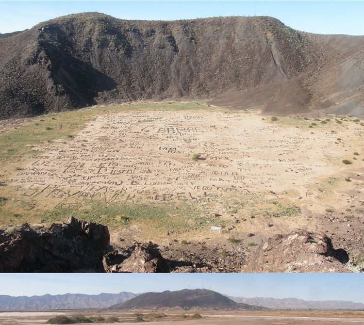
Cerro Prieto is a 223 m isolated, inactive volcano found near Mexicali, Mexico (Baja) that rises prominently from the surrounding agricultural fields. It lies on the northwest-striking Cerro Prieto fault. Along with the San Andreas and Imperial faults to the north, Baja represents a transition region between the sliding San Andreas Fault and the crustal opening along the East Pacific Rise, extending stepwise down the length of the Sea of Cortex.Paleomagnetic data suggests that Cerro Prieto (dark hill) was active between 100,000 and 10,000 years ago. Tales of its most recent activity has been preserved in Cucupas Indian lore. Though this dacitic volcano has been inactive for thousands of years, the region experiences high geothermal heat flow from a shallow magma body, estimated to be only 5 to 6 km below the surface. Hot subsurface brines are brought to the surface where they evaporate and drive electric generators. An earthquake swarm occurred under Cerro Prieto in February 2008.The small but conspicuous volcano is topped by a number of microwave communication towers. Nowadays, local kids entertain themselves by writing their names and making drawings on the caldera floor by arranging pieces of volcanic rock. Comparison of this picture with that on Google Earth shows that there is considerable human activity in the caldera - http://epod.usra.edu/blog/2009/02/cerro-prieto-volcano.html. |
Cerro Prieto is a small dacitic lava dome in the Cerro Prieto geothermal field at the northern end of the Gulf of California, 33 km south of Mexicali at the Mexican border or 175 km SE of San Diego. Holocene? Cerro Prieto lies in an active continental rift that is transitional between the transform San Andreas fault system to the north and a spreading ridge of the East Pacific Rise in the Gulf of California to the south. The only surficial volcanic feature at Cerro Prieto, which is located near sea level on the Colorado River delta, is a small, 223-m-high compound dacitic lava dome. A 200-m-wide crater is located at the summit of the NE-most dome. The Cerro Prieto dome was roughly estimated from paleomagnetic evidence to have formed during a series of events between 100,000 and 10,000 years ago. Cucupas Indian legends described a monster that covered the land with hot rocks, which grew through the soil and emitted fire tongues, a possible reference to the growth of the volcano. |
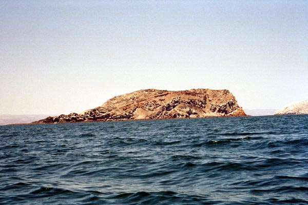
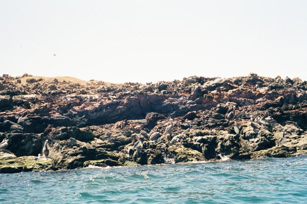
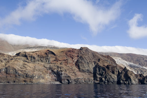
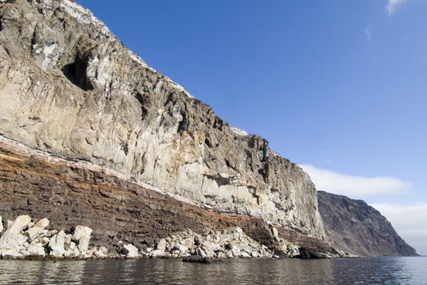
Isla San Luis volcano forms the largest of the 7 Encantada islands in the northern part of the Gulf of California, about 3 km offshore. It is 4.5 sq km large and consists of a 180 m high cone with a narrow peninsula on the SW end. It is not known when the volcano last erupted, but it could have been less than 100 years ago. http://www.volcanodiscovery.com/baja-california.html http://www.kayaker.net/page.php?id=bajn8 |
Isla San Luis |
Isla San Luis -tuff cone. The volcano is located at the NW end of the Guaymas lineament. Initial basaltic-andesite and andesitic submarine surtseyan eruptions produced palagonite tuffs and were followed by the effusion of subaerial dacitic lava flows and the formation of dacitic tuff rings. |
Isla San Luis, 180m, Holocene. Isla San Luis or Salvatierra area http://www.kayaker.net/page.php?id=bajn8- |
Isla San Luis or Salvatierra areahttp://www.kayaker.net/page.php?id=bajn8 - |
Isla San Luis volcano -http://www.kayaker.net/page.php?id=bajn8 |
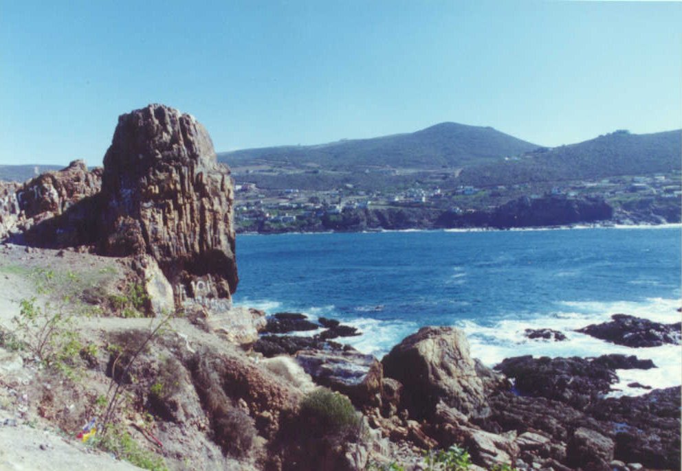
Near Ensenada - Baja California |
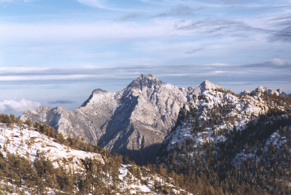
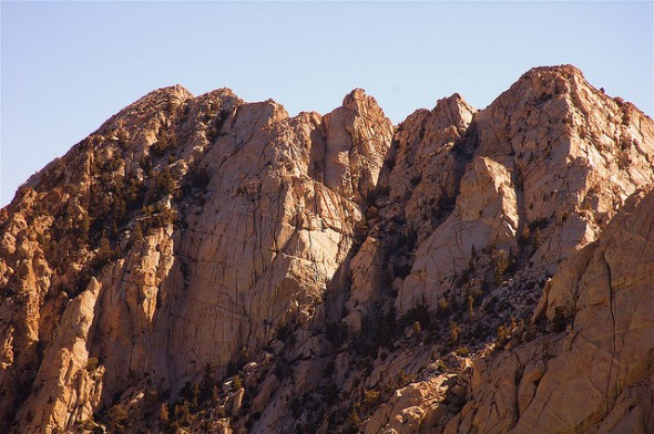
Picacho del Diablo -http://climber.org/reports/2001/741.html |
Picacho del Diablo, Peninsular Ridge. Peninsular photos - http://climber.org/reports/2001/741.html http://euroeclipse99.tripod.com/mexico/ |
Picacho del Diablo is the highest peak on the Baja California peninsula, measuring 3,096 m. It is alternately called Cerro de la Encantada. The peak is located in the Sierra San Pedro Martir in the Mexican state of Baja California. http://en.wikipedia.org/wiki/Picacho_del_Diablo |
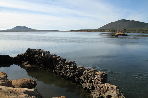
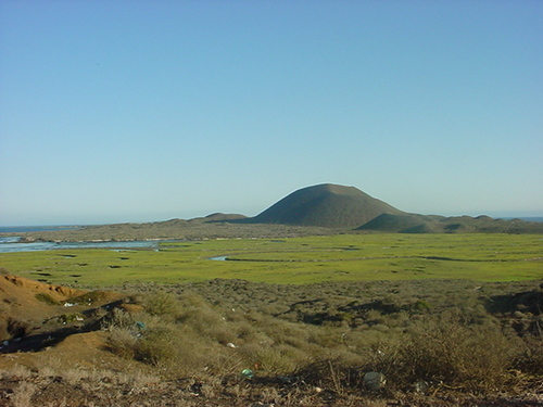
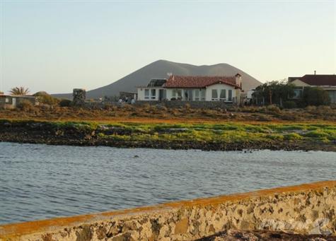
Bahia de San Quintin Baja California Mexico |
Los Humedales Mediterraneos y los Volcanes extintos de la Bahia de San Quintin Baja California Mexico |
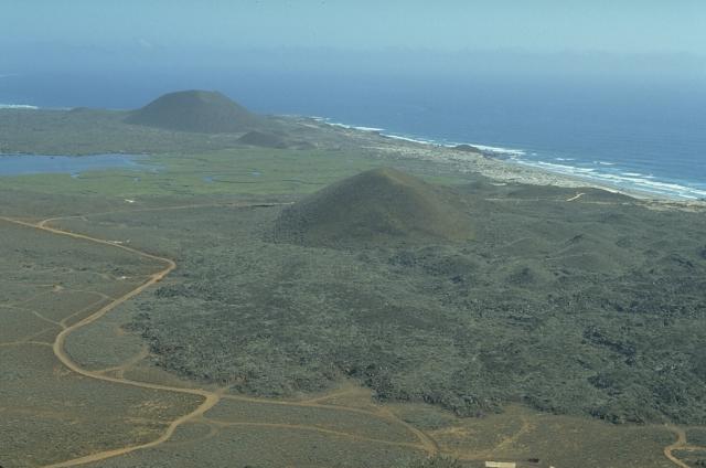
El Pedregal San Quintin Baja California Mexico.San Quintin volcanic field on the NW coast of Baja California contains lava shields capped by youthful scoria cones. This view looks south from Volcan Basu to Picacho Vizcaino (surrounded by young lava flows), and Volcбn Sudoeste (upper left). These are among the youngest features of the San Quintнn field. Along with Monte Mazo to the SSE, they are constructed along a N-S line. |
San Quintin volcanic field (cinder cones)on the NW coast of Baja California contains lava shields capped by youthful scoria cones. This view looks south from Volcбn Basu to Picacho Vizcaino (surrounded by young lava flows), and Volcбn Sudoeste (upper left). These are among the youngest features of the San Quintнn field. Along with Monte Mazo to the SSE, they are constructed along a N-S line.Cinder cone. Holocene? San Quintнn volcanic field on the NW coast of Baja California consists of 11 late-Pleistocene to Holocene volcanic complexes. Low lava shields, initially submarine, are capped by well-preserved scoria cones. San Quintнn rocks are similar to intraplate or oceanic island alkalic rocks and differ from other Baja alkalic volcanic suites. San Quintнn is the only Quaternary volcanic field in Baja California where lower-crustal and upper-mantle xenoliths are found. The field is located at the margins of the Y-shaped San Quintнn Bay and includes a northern and southern group of cones, Monte Mazo (connected to the mainland by a long tombolo), and Isla San Martнn, 5 km offshore to the west. The youngest craters overlie deposits thought to be dated at 5-6000 years before present, and Gastil et al. (1975) considered the southern cones of Vizcaino and Sudoeste to possibly be less than 3000 years old. However, later Argon/Argon dating (Ortega-Rivera et al., 2004) restricted eruptions to a range of between about 20,000 to 180,000 years ago. Summit 260m. - http://www.volcano.si.edu/world/volcano.cfm?vnum=1401-002 http://www.volcanodiscovery.com/san_quintin.html |
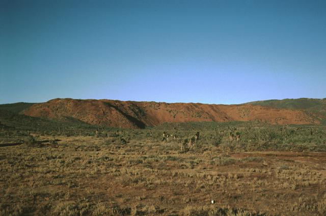
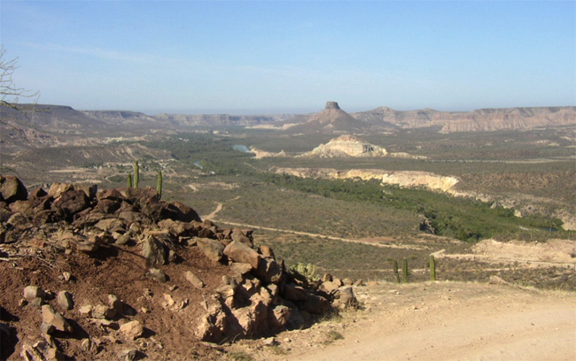
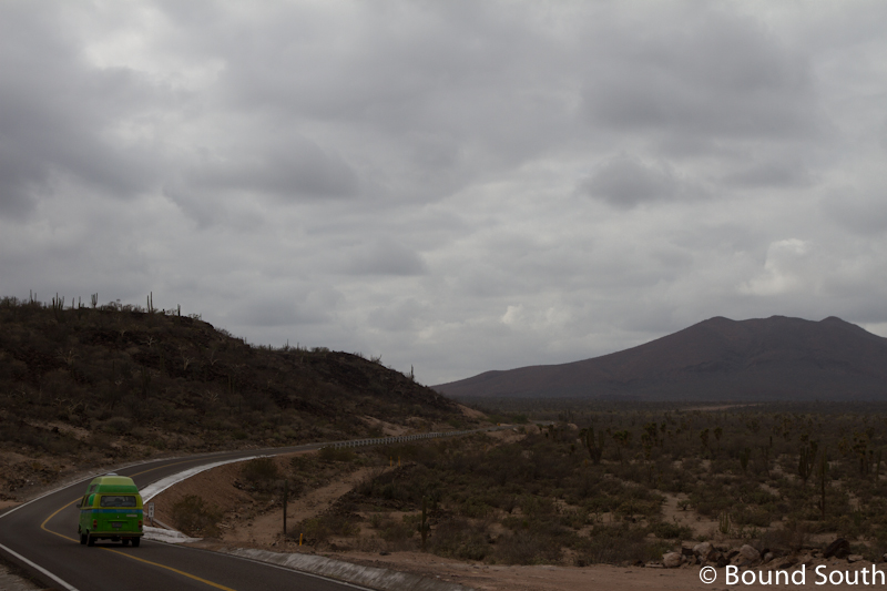
San Borja volcano, 1360m, Holocene, last eruption unknovn, also known as El Rosarito, is a volcanic field in central Baja California NE of the Vizcaino Peninsula. There are young cinder cones and lava flows near Rosarito and Morro San Domingo at the western end of the field and along the coast north of the Vizcaino Peninsula.http://www.volcanodiscovery.com/baja-california.html The San Borja volcanic field, also known as the El Rosarito volcanic field, is located in central Baja California NE of the Vizcaino Peninsula. Holocene lava flows occur at Rosarito and Morro San Domingo at the western end of the San Borja volcanic field along the coast north of the Vizcaino Peninsula. Some lava flows of the San Borja volcanic field are less vegetated than flows of the San Quintнn volcanic field to the north that overlie 5000-6000 year-old midden deposits (Rogers et al., 1985). The Holocene lava flows in the western part of this alkalic volcanic field are of basaltic-andesite and andesitic composition.The orange-brown ridge in the background is a thick, blocky basaltic-andesite lava flow of probable Holocene age that is part of the San Borja volcanic field. The flow is seen here from state highway 1 in central Baja California. The sparsely vegetated flow is one of many youthful lava flows of the San Borja volcanic field. Holocene lava flows of the San Borja field occur near Rosarito and Morrow San Domingo, at the western end of the San Borja region north of the Vizcaino peninsula.Photo by Andy Saunders, 1984 (University of Leichester).http://www.volcano.si.edu/world/volcano.cfm?vnum=1401-007&volpage=photos |
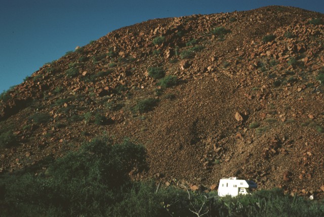
The steep-sided margin of a thick, blocky basaltic-andesite lava flow is seen from near state highway 1 in central Baja California with a pickup camper for scale. The sparsely vegetated flow is of probable Holocene age and is one of many youthful lava flows of the San Borja volcanic field. http://www.volcano.si.edu/world/volcano.cfm?vnum=1401-007&volpage=photos |
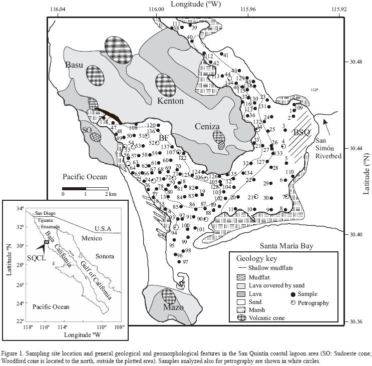
A detailed regional grid of 97 surficial sediment samples is studied for the San Quintнn coastal lagoon, which is a shallow embayment located adjacent to a "regionallyЁCrare" intraplateЁCtype basaltic terrain known as San Quintнn volcanic field. The influence that this unique lithology and other potential sources have on the recent sediment geochemistry is discussed on the basis of geochemical, petrographic and sedimentological results. The sandy silts and silts in the lagoon are enriched in ferromagnesian minerals such as pyroxenes and hornblende, which form up to 6 and 22%, respectively, of the total mineral count in the sand fraction. These relatively immature feldspathic sediments are characterized by the presence of abundant angular plagioclase (25ЁC60%) and absence of lithics. The LaЁCScЁCTh and CrЁCScЁCTh discrimination diagrams suggest that mafic ferromagnesian minerals have a significant effect on the geochemical variance of the sediments. The Cr/Th (median=28) and Co/Th (median=59) ratios are similar to those reported for sands derived from basic rocks. A mafic provenance is probably responsible for the statistical association of Fe, Hf, U, Th, Sc, Cr, Ca, Na and the rare earth elements. An association of Fe, organic carbon and total P with the trace elements Sb, Cr, Br, As, Na, Sc and Co indicates that their distribution is mainly controlled by the presence of FeЁCrich minerals, such as hornblende, and organic matter throughout Bahнa San Quintнn and the northernmost Bahнa Falsa, beneath aquaculture racks. Low enrichment factors (<1) for Cr, Sb, As and P indicate that anthropogenic contaminant sources derived from agrochemicals are not significant -http://www.scielo.org.mx/scielo.php?script=sci_arttext&pid=S1026-87742009000100010 |
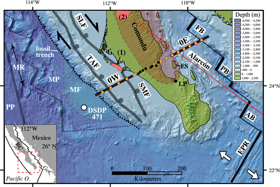
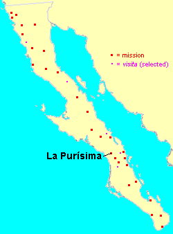
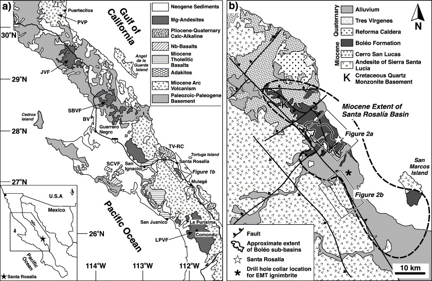
Major fault systems around southern Baja California (BC; black lines). Ocean-bottom seismometers (orange squares) and land-based seismometers (black squares) are located along line zero. Black lines are multichannel seismic reflection profiles 0W and 0E. Alarcуn profile is from Lizarralde et al. [2007]. Abbreviations: Magdalena Fan (MF), fossil Magdalena Ridge (MR), Tosco-Abreojos Fault (TAF), Santa Margarita Fault (SMF), Deep Sea Drilling Program (DSDP) Site 471, Pacific Plate (PP), Magdalena microplate (MP), East Pacific Rise (EPR). Post-subduction volcanism [Calmus et al., 2011, and references therein]: (1) 6.2 ЎА 0.1 and 4.9 ЎА 0.1 Ma adakites on Isla Santa Margarita; (2) 9.7ЁC8.8 Ma La Purisima magnesian andesites (i.e., Ў░bajaitesЎ▒). Orange region represents Comondъ volcanics. Bathymetric data was downloaded with GeoMapApp (http://www.geomapapp.org).http://www.agu.org/journals/gl/gl1209/2011GL050828/figures.shtml |
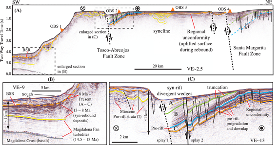
Seismic reflection profile 0W. (a) Line 0W (total length = 111 km) and locations of OBS receivers 1ЁC5. (b and c) Enlarged sections show stratigraphy in the paleo-trench and TAF basin. Estimates for stratal ages are based on correlation with DSDP Site 471 [Yeats et al., 1981]. |
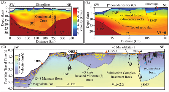
(a) Velocity model for BC. (b) Expanded region of dashed box in Figure 3a. The high velocity zone (HVZ) extending beneath the western half of the Magdalena shelf and is interpreted to be Magdalena oceanic crust. (c) Merged seismic reflection profile and velocity model of the Magdalena Shelf |
(aЁCe) Proposed tectonic evolution from ∼16 Ma to present, respectively. http://www.agu.org/journals/gl/gl1209/2011GL050828/figures.shtml (GEOPHYSICAL RESEARCH LETTERS, VOL. 39, L09307, 7 PP., 2012 ) see |
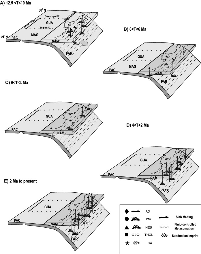
Post-subduction volcanism in the Baja California Peninsula, Mexico: The effects of tectonic reconfiguration in volcanic systems -http://www.sciencedirect.com/science/article/pii/S0024493707001776 Late Cenozoic volcanism in the Baja California Peninsula records the effects of cessation of subduction at a previously convergent plate margin. Prior to 12.5 Ma the predominant volcanic activity had a calc-alkaline signature, however, after 12.5 Ma during the period of tectonic transition from a convergent to a strike-slip boundary, the style and composition of the magmatic products changed dramatically. It has been proposed that the origin of the post-subduction Ў░anomalousЎ▒ slabЁCmelt-related magmas (i.e., adakites, niobium-enriched basalts, magnesian andesites) is linked to regional tectonic events such as the subduction of an active ridge, the breakoff of the subducted slab, or the tearing of the stalled slab. Here, we compile already published data on this volcanism and critically examine the tectonic models proposed to explain its origin. An alternative approach, based on a physical model of volcanic systems, suggests that post-subduction volcanism is strongly influenced by more local aspects including the stress field and the tensile strength of the rock overlying the zones where partial melting occurred. This interpretation allows us to reconcile the apparent contradictory observations of the temporal and spatial distributions of post-subduction activity, providing a more adequate explanation of many characteristics of the Baja California post-subduction volcanism. |
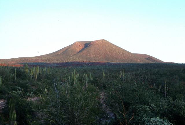
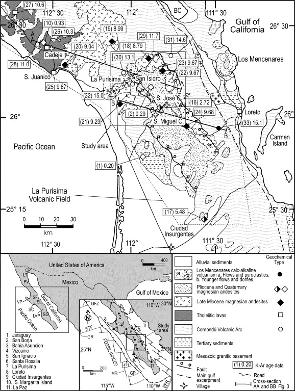
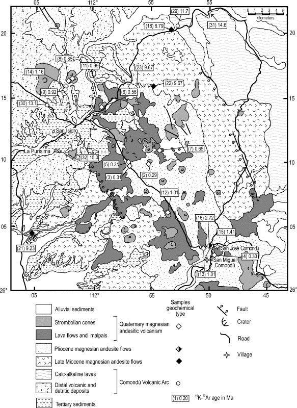
The Comondu-La Purisima volcanic field, located in southern Baja California, west of the Sierra de la Giganta, dates back to the Miocene. However, the youthful morphology of some cinder cones suggested possible Holocene ages (Sawlan, 1991). The youngest lavas form blocky flows with flow ridges and are mostly located in the area between Comondu and the La Purisima river. Vents usually occur along NNW-trending faults, and many lava flows are offset, sometimes repeatedly, along grabens. Both basaltic and andesitic lava flows are present. The former are typically 5-10 m thick, and the latter are up to 60-80 m thick and form dense, glassy flows with subhorizontal fractures.Volcanic field, Holocene? 780m, last eruption unknown.A young cinder cone rises above cactus-covered terrain NE of the town of La PurĒsima. The Comond·-La PurĒsima volcanic field, located in southern Baja California, west of the Sierra de la Giganta, has been active from the Miocene to the Quaternary. The youngest lavas form blocky flows with flow ridges and are mostly located in the area between Comond· and La PurĒsima river. Vents usually occur along NNW-trending faults, and many lava flows are offset, sometimes repeatedly, along grabens Photo by Brian Hausback, 1983 (California State University, Sacramento).http://www.volcano.si.edu/world/volcano.cfm?vnum=1401-012&volpage=photos volcanic field of about 9000 sq km in southern Baja California, west of the Sierra de la Giganta. The field was formed about 10 million years ago as a consequence of subduction of the Farallon and Guadalupe plates below Baja California. Vents in the Comond·-La PurĒsima volcanic fields usually occur along NNW-trending faults, and many lava flows are offset, sometimes repeatedly, along grabens. There are both basaltic and andesitic lava flows. The basaltic flows are typically 5-10 m thin while andesitic flows, due to their greater viscosity are up to 60-80 m thick and form dense, glassy flows with subhorizontal fractures.Typical eruption style: effusive. No earthguakes http://www.volcanodiscovery.com/baja-california.html |
Comondu-La Purisima volcanic field, 26.00 N, 111.92 W , summit elevation 780 m is located in southern Baja California. The field extends over an area of almost 9000 sq km. Volcanic activity of La Purэsima area is related to the subduction of the Farallon and Guadalupe plates below Baja California http://www.volcanolive.com/purisima.html. Eruptions 1) Normal to K-rich calc-alkaline lavas were erupted over 11 MA.2) Magnesium andesites and tholeiites were erupted 10.6 to 8.8 MA.3) Small volumes of magnesium andesites erupted in the central and southern parts of the volcanic field, in two eruptions 5.5 and 2.5 MA.4) The most recent eruptions produced basaltic and magnesium andesitic fissural and central emissions. This formed strombolian cones and associated lava flows, mainly distributed within a NNWЁCSSE trending graben located SE of the town of La Purэsima. |
La Purisima volcanic field, Baja California Sur (Mexico): Miocene to Quaternary volcanism related to subduction and opening of an asthenospheric window http://www.sciencedirect.com/science/article/pii/S0377027305003598 Geological mapping and geochemical analyses combined with 40KЁC40Ar ages for lavas from the Late Miocene to Quaternary La Purisima volcanic field (Baja California Sur) provide evidence for five volcanic events. These, in turn, may reflect plate interactions in the region. The oldest event (event 1), prior to 11 Ma, corresponds to the emission of normal to K-rich calc-alkaline lavas, exposed as large mesas in the eastern part of the studied area and as pyroclastic breccias and volcaniclastic sediments to the west. It is associated with the end of the Comondъ arc activity resulting from subduction of the Farallon and Guadalupe plates. Between 10.6 and 8.8 Ma (event 2), magnesian andesites and tholeiites were emplaced. At 5.5 Ma (event 3) and 2.5 Ma (event 4) small volumes of magnesian andesites erupted in the central and southern parts of the volcanic field. Finally, between 1.2 Ma and Holocene (event 5), numerous basaltic and magnesian andesitic fissural and central emissions resulted in the formation of strombolian cones and associated lava flows, mainly distributed within a NNWЁCSSE trending graben located SE of the town of La Purisima.Magmatic events 2 to 5 occurred well after the supposed end of the subduction event. Their geochemical characteristics are still typical of subduction-modified sources and possibly indicate partial melting of hot slab and formation of an asthenospheric window due to a slab rupture event which followed ridgeЁCtrench collision, prior to the continental breakup of the Gulf of California extensional province. |
La Purisima volcanic field |
Santa Clara volcanic Field .location of main volcanic fields: 1ЎЄJaraguay; 2ЎЄSan Borja; 3ЎЄ - http://geology.gsapubs.org/content/29/6/531/F1.expansion.html Jaraguay volcanic field is located in northern Baja California, Mexico. The volcano contains cinder cones and associated basaltic and basaltic-andesite lava flows.The volcano lies between Jaraguay and Arroyo San Jose on the western side of Baja California. Eruptions have occurred in the past 5000-6000 years. No recent eruptions. It contains cinder cones and associated basaltic and basaltic-andesite lava flows, some of which are probably less than about 5000 years old. The Jaraguay volcanic field is the northernmost of a group of large young alkalic volcanic fields in Baja California. Located primarily on the Pacific Ocean side of northern Baja between Jaraguay and Arroyo San Jose, the Jaraguay field contains numerous youthful-looking cinder cones and associated basaltic and basaltic-andesite lava flows. Some lava flows are less vegetated than flows of the San Quintнn volcanic field to the north that overlie 5000-6000 year-old midden deposits (Rogers et al., 1985). Several Holocene lava flows were erupted near the south side of Arroyo San Josй at the SW end of the Jaraguay volcanic field. (Smithsonian / GVP volcano information). volcanic field 960? M. Typical eruption style: effusive. No recent eartyhquakes http://www.volcanodiscovery.com/baja-california.html |
Volcanic Province; JVFЎЄJuaraguay volcanic field; SBVFЎЄSan Borja http://www.sciencedirect.com/science/article/pii/S0377027304004093 San Borja volcanic field, 1360m, also known as El Rosarito, is a volcanic field in central Baja California NE of the Vizcaino Peninsula. There are young cinder cones and lava flows near Rosarito and Morro San Domingo at the western end of the field and along the coast north of the Vizcaino Peninsula. Typical eruption style: effusive. Last eruption 5000-600 years ago. No recent earthquakes - http://www.volcanodiscovery.com/baja-california.html |
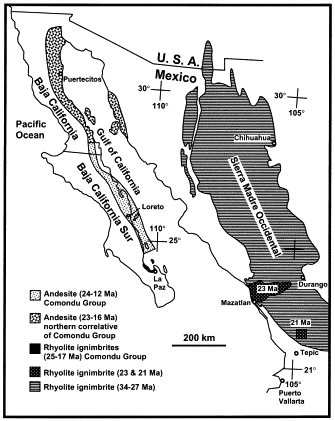
Stratigraphy and geochronology of the Comondu Group near Loreto, Baja California sur, Mexico- http://www.sciencedirect.com/science/article/pii/S0037073801001385 |
Volcanic activity of La Purэsima dates back about 10 MA, but might have continued into the Holocene, as some of the cinder cones and blocky lava flows, in the area between Comondu and the La Purisima river, have preserved a very fresh morphology. The field was formed about 10 MA as a consequence of subduction of the Farallon and Guadalupe plates below Baja California. Vents in the Comondu-La Purisima volcanic fields usually occur along NNW-trending faults, and many lava flows are offset, sometimes repeatedly, along grabens. There are both basaltic and andesitic lava flows. The basaltic flows are typically 5-10 m thin while andesitic flows, due to their greater viscosity are up to 60-80 m thick and form dense, glassy flows with subhorizontal fractures. Typical eruption style: effusive. No recent earthquakes.http://www.volcanodiscovery.com/comondu-la_purisima.html |
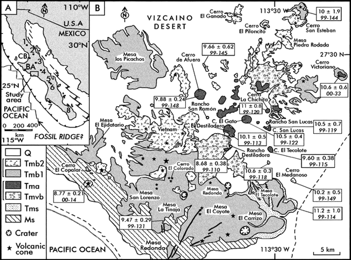
Volcanoes near Santa Rosalia, Baja California Sur |
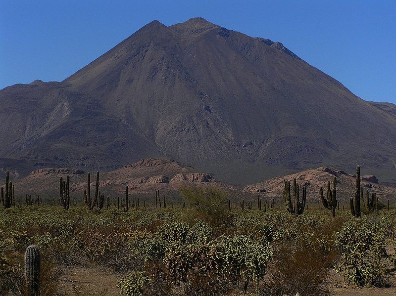
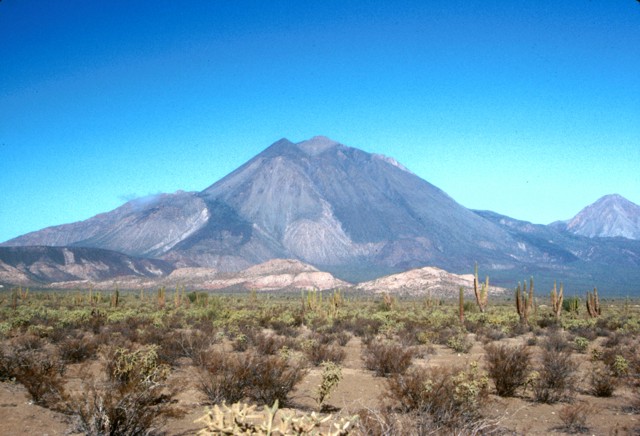
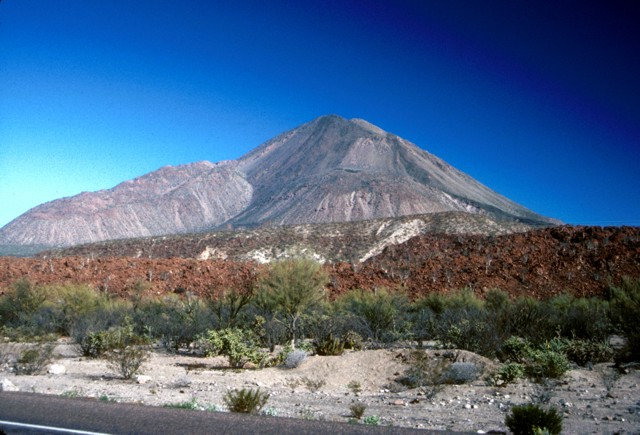
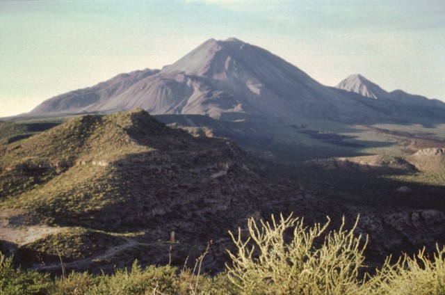
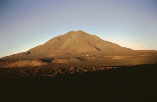
Tres Virgenes,1940m, last eruption 1857.Tres V¦Яrgenes volcano is a complex of 3 stratovolcanoes, El Viejo, El Azufre, and La Virgen, in east-central Baja California and the only larger volcano on the peninsula. The 3 volcanoes, El Viejo, El Azufre, and La V¦Яrgen were constructed along a NE-SW line and are progressively younger to the SW. The youngest volcano, La V¦Яrgen, is an andesitic stratovolcano with numerous dacitic lava domes and lava flows on its flanks. A major plinian explosive eruption from a SW-flank vent was radiocarbon dated at about 6500 years ago, but Helium exposure and Uranium-series dates give a late-Pleistocene age for this event. An ash plume was reported from Tres V¦Яrgenes volcano by a Spanish Jesuit priest while navigating the Gulf of California in 1746. No tephra deposits from such a young eruption have been found, but young undated andesitic lava flows at the summit could potentially be related to this event. (Source: Smithsonian / GVP) -http://www.volcanodiscovery.com/tres_virgenes.html |
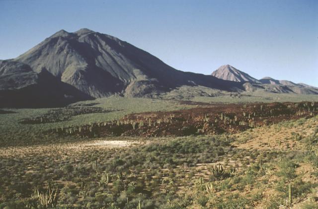
The Tres Vigenes volcanic complex consists of three stratovolcanoes constructed along a NE-SW line. La V¦Яrgen (the youngest and highest peak) is seen here at the left from the SE, with El Azufre forming the sharp peak at the right and the still older El Viejo forming the low peak at the extreme right. The sparsely vegetated dark lava flow in the center foreground is one of the youngest from La Virgen volcano. A major plinian explosive eruption from a SW-flank vent took place about 6500 years ago and was followed by effusion of a thick lava flow.The Tres V¦Яrgenes volcanic complex consists of three stratovolcanoes constructed along a NE-SW line. La V¦Яrgen (the youngest and highest peak) is seen here at the left from the SE, with El Azufre forming the sharp peak at the right and the still older El Viejo forming the low peak at the extreme right. The sparsely vegetated dark lava flow in the center foreground is one of the youngest from La Virgen volcano. A major plinian explosive eruption from a SW-flank vent took place about 6500 years ago and was followed by effusion of a thick lava flow. Photo by Jose Macias, 1995 (Universidad Nacional Autonoma de Mexico).Sharp-topped 1650-m-high El Azufre volcano (center) is the central peak of the Tres VЁЄrgenes volcanic complex. Its summit lies about 4 km north of the highest peak of the complex, La VЁЄrgen (left). The small peak on the horizon immediately to the right of El Azufre is 1370-m-high El Viejo, the oldest peak of the southward-younging Tres VЁЄrgenes complex. El Viejo was constructed SW of the Pleistocene El Aguajito caldera, barely visible on the far right horizon. Both El Viejo and El Azufre are composed of dacitic lava domes and flows. http://www.volcano.si.edu/world/volcano.cfm?vnum=1401-01=&volpage=photos |
The Tres VЁЄrgenes volcanic complex in central Baja California consists of a NE-SW-trending chain of three volcanoes. Volcanism has migrated over time to the SW. This view from the SE shows the intermediate-age volcano, El Azufre, on the right and the highest and youngest volcano, La VЁЄrgen, on the left. The latest major eruption, about 6500 years ago, produced a plinian pumice-fall deposit and thick, viscous lava flows from a SW-flank vent near the notch seen halfway up the volcano''s left flank.Photo by Brian Hausback, 1990 (California State University, Sacramento).http://www.volcano.si.edu/world/volcano.cfm?vnum=1401-01=&volpage=photos |
Las Tres Vнrgenes volcano is viewed from the SSE. The steep-sided viscous Southwest Coulee (La Vнrgen) lava flow is prominent on the left horizon. Lava flows from Mesquital dome (reddish-brown color) are visible in the foreground. This lava dome lies on the lower southern flank of the volcanic complex near the highway.Photo by Brian Hausback, 1990 (California State University, Sacramento).http://www.volcano.si.edu/world/volcano.cfm?vnum=1401-01=&volpage=photos |
The two most prominent peaks of the Tres Vнrgenes volcanic complex in central Baja California are seen here from the SSW. The steep-sided peak at the left is 1660-m-high El Azufre, a dacitic lava dome complex. La Vнrgen (right), the youngest and highest peak, has a more complex history. This roughly 1940-m-high volcano consists of andesitic lava domes and andesitic flank scoria cones. It has erupted from both summit and flank vents and has produced both plinian explosive eruptions and dacitic and andesitic lava flows.A panoramic view from the SE shows the Tres Vнrgenes volcanic group, which is aligned in a SW-NE direction. Volcanism has migrated to the SW from the oldest peak El Viejo (extreme right) through El Azufre to La Vнrgen (center), the highest peak. Prominent ridges exposed on the left flank of La Vнrgen are rhyodacitic lava flows from the youngest major eruption. The smooth hills in the left foreground are Quaternary ignimbrite sheets probably related to La Reforma, a Pleistocene caldera east of Tres Vнrgenes.Photo by Jose Macias, 1995 (Universidad Nacional Autonoma de Mexico). |
The setting sun colors the SSW flank of Tres Vнrgenes, the highest volcano in Baja California. Much of the volcano consists of lava domes and viscous lava flows. The protruding hills on the volcano''s flanks are the rhyodacitic lava flows associated with the last plinian eruption of the volcano about 6500 years ago. The aligned flat terraces on the plain are underlain by basaltic-andesitic lava flows of Tertiary age. A producing geothermal plant at Tres Vнrgenes supplies electricity to the Santa Rosalia grid. Photo by Jose Macias, 1995 (Universidad Nacional Autonoma de Mexico).http://www.volcano.si.edu/world/volcano.cfm?vnum=1401-01=&volpage=photos |
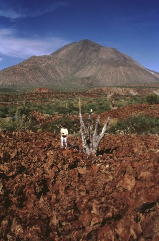
A major plinian eruption about 6500 radiocarbon years ago from a vent on the SW flank at about 1400 m elevation produced a widespread pumice-rich fallout deposit and minor pyroclastic surges. The vent is located at the notch on the middle left skyline and was also the source of the 100-m-thick rhyodacitic lava flow that forms the lower left part of the cone. A volcanologist from the National University of Mйxico stands in the foreground on a blocky basaltic-andesite lava flow that may have been emplaced late in this eruptive sequencePhoto by Jose Macias, 1995 (Universidad Nacional Autonoma de Mexico).http://www.volcano.si.edu/world/volcano.cfm?vnum=1401-01=&volpage=photos |
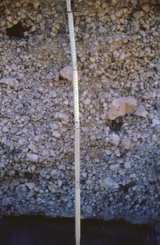
The middle unit of the La Vнrgen plinian fall deposit displays a massive structure with large pink-colored pumice fragments. This deposit is the product of a plinian explosive eruption that occurred about 6500 radiocarbon years ago during the last major eruption of Tres Vнrgenes volcano. The dispersal axis of this more than 1 cu km airfall deposit was to the SW. The eruption also included the emplacement of pyroclastic flows and voluminous lava flows.Photo by Jose Macias, 1995 (Universidad Nacional Autonoma de Mexico).http://www.volcano.si.edu/world/volcano.cfm?vnum=1401-01=&volpage=photos |
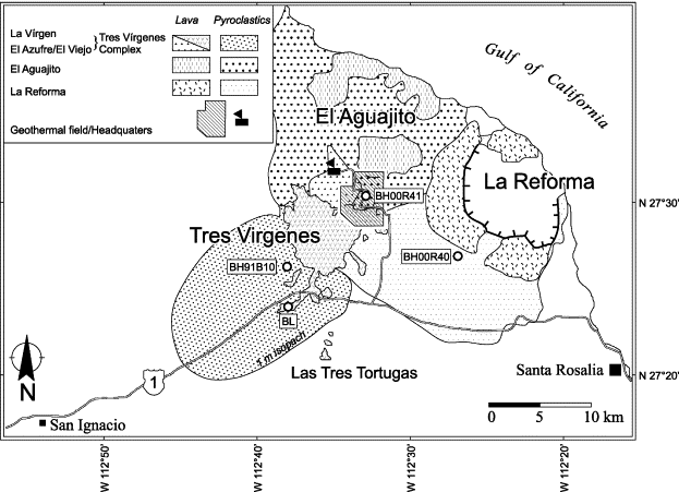
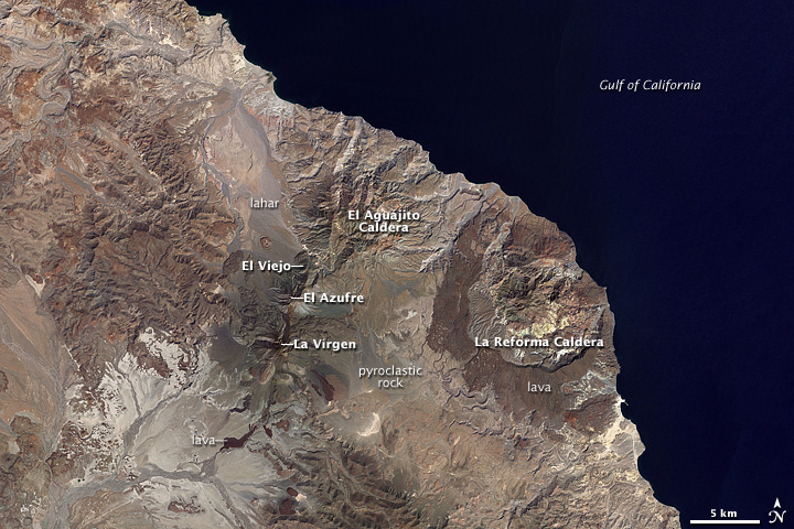
Geologic map of the Tres Virgenes Volcanic Complex (TVCC) and adjacent Aguajito and La Reforma calderas). 1-m-isopach line drawn for La Virgen tephra deposit. Sample localities and the location of the geothermal area are indicated: Ў░BLЎ▒ refers to the Highway Basalt locality, previously dated by cosmogenic He exposure methods (Hausback and Abrams, 1996), all others are samples from this study-http://www.sciencedirect.com/science/article/pii/S0377027306003210 (Eruption and magma crystallization ages of Las Tres Virgenes).The Tres Virgenes, a line of three connected volcanoes, collectively known by that name, are west of La Reforma Caldera. La Virgen, in the southwest, El Azufre in the center, and El Viejo in the northeast. The volcanoes get larger and younger from northeast to southwest. As recently as 6,500 years ago, La Vнrgen experienced a Plinian eruption ЎЄ a huge, explosive event that produces an enormous column of volcanic rock fragments and gas that reaches into the stratosphere. The eruption produced a column that reached at least 18 kilometers into the air and deposited ash and rock fragments over 500 km3. In later stages of the eruption, pyroclastic flows (pinkish rocks) and lahars (mudflows, grayish rocks) from El Azufre Volcano paved the plain to the north all the way to the Gulf of California.La Reforma Caldera facing the Gulf of California, near Santa Rosalia. The outer rim of the caldera is defined by dark-colored rocks made out of very fluid lava. A dome of rock in the center of the caldera is a resurgent dome. A resurgent dome is formed as the floor of the caldera is heaved upward by the movement of magma below ground. The lavas surrounding the caldera date to about 1 MA. El Aguajito volcano (also known as Santa Ana caldera) is a large 10 km wide caldera at the coast of the Gulf of California, northwest of the older La Reforma caldera. The caldera formed during massive eruptions about 7600,000 years ago in what would be called a super-volcano eruption, and its rim is no longer exposed. A series of lava domes that formed about 500,000 years ago, occupy its northern edge. There is an active geothermal system with hot springs along the southern side of the caldera. The rim of the approximately 10-km-wide resurgent caldera is not exposed, but an arcuate line of andesitic-to-rhyolitic lava domes covers its northern margin. Formation of the rhyolitic caldera was associated with the eruption of ignimbrites, K-Ar dated at 0.76 +/- 0.06 MA, most of which were deposited in the Gulf of California. Rhyolitic lava domes on the northern margin have been dated at 0.5 +/- 0.04 Ma; dacitic lava domes on the southern side of the caldera appear to be older. The regional NNE-SSW-trending Cimarron fault cuts across the center of the caldera. Hot springs are located along the southern caldera margin, and active seismicity was noted during geothermal exploration. (source: Smithsonian / GVP) |
Volcanoes of the east-central Baja California Peninsula -http://en.wikipedia.org/wiki/Volcanoes_of_east-central_Baja_California El Aguajito Caldera, 1300m, is north-northeast of Las Tres Virgenes, where pyroclastic rocks and lava date to between 500,000-800,000 years old. The rim of the caldera is not continuously exposed at the surface, but the rocks have a subtle circular arrangement. Like La Reforma, the northern rim of El Aguajito follows the coastline. The flat-looking rock formations, carved by arroyos, are lava domes, hardened mounds of slow-moving, sticky lava. The topography in the southern part of the caldera is more rugged and irregular. The rocks are a combination of pyroclastic deposits and a slightly more fluid lava than what erupted near the coast.The arid climate of Baja California limits the amount of vegetation covering the ground and allows the dramatic volcanic features of the landscape to stand out in this natural-color image from the Landsat 7 satellite on October 5, 2000. The landscape is a patchwork of lava flows and the hardened remains of pyroclastic flows ЎЄ hot clouds of volcanic ash, dust, and rock fragments that race down the slopes of a volcano like an avalanche.http://earthobservatory.nasa.gov/IOTD/view.php?id=36205 El Aguajito volcano (also known as Santa Ana caldera) is a large 10 km wide caldera at the coast of the Gulf of California, northwest of the older La Reforma caldera. The caldera formed during massive eruptions about 7600,000 years ago in what would be called a super-volcano eruption, and its rim is no longer exposed. A series of lava domes that formed about 500,000 years ago, occupy its northern edge. There is an active geothermal system with hot springs along the southern side of the caldera.El Aquagita -1300m, The rim of the approximately 10-km-wide resurgent caldera is not exposed, but an arcuate line of andesitic-to-rhyolitic lava domes covers its northern margin. Formation of the rhyolitic caldera was associated with the eruption of ignimbrites, K-Ar dated at 0.76 +/- 0.06 million years ago (Ma), most of which were deposited in the Gulf of California.Rhyolitic lava domes on the northern margin have been dated at 0.5 +/- 0.04 Ma; dacitic lava domes on the southern side of the caldera appear to be older. The regional NNE-SSW-trending Cimarron fault cuts across the center of the caldera. Hot springs are located along the southern caldera margin, and active seismicity was noted during geothermal exploration. (source: Smithsonian / GVP)- http://www.volcanodiscovery.com/el_aguajito.html El Aguajito caldera (also known as Santa Ana caldera) is located along the Gulf of California immediately NE of Tres Vнrgenes volcano and NW of La Reforma caldera. The rim of the approximately 10-km-wide resurgent caldera is not exposed, but an arcuate line of andesitic-to-rhyolitic lava domes covers its northern margin. Formation of the rhyolitic caldera was associated with the eruption of ignimbrites, K-Ar dated at 0.76 +/- 0.06 million years ago (Ma), most of which were deposited in the Gulf of California. Rhyolitic lava domes on the northern margin have been dated at 0.5 +/- 0.04 Ma; dacitic lava domes on the southern side of the caldera appear to be older. The regional NNE-SSW-trending Cimarron fault cuts across the center of the caldera. Hot springs are located along the southern caldera margin, and active seismicity was noted during geothermal exploration.Three major Quaternary volcanic complexes are visible in this Landsat satellite image of Baja California. The N-S-trending Las Vнrgenes volcanic complex at the left center consists of three southward-younging stratovolcanoes. The dramatic 10-km-wide La Reforma caldera along the Gulf of California coast at the upper right displays dark-colored andesitic outer flanks and a resurgent dome in the center of the caldera. The extensively eroded El Aguajito caldera lies north of Tres Vнrgenes and NW of La Reforma and has indistinct margins.http://www.volcano.si.edu/world/volcano.cfm?vnum=1401008B&volpage=photos |
|
http://www.csus.edu/indiv/h/hausback/PDFs%20of%20Publications/Hausback%201984%20Cenozoic%20Volcanic%20and%20Tectonic%20Evolution%20-%20Baja.pdf |
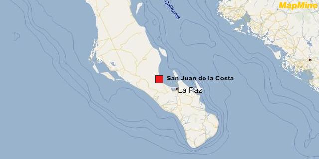
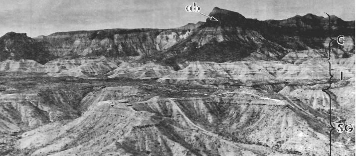
Aeral view west of the San Juan de la Costa area showing flat-bedded strarigraphy. San Gregorio Formation (SG), Isidro Formation (I), and lower part of Comondu Formation (C) including a prominent cliff-forming andesitic breccia or lahar (ab) |
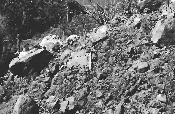
Outcop of andesitic lahar in the lower Comondu Formation. Hammer is 0.5 m long.The matrix-supported angular blocks and the massive to poorly stratified character of deposits. |
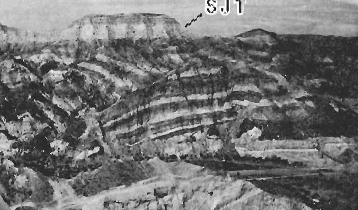
View to the northwest, at the mouth of Arrow Saizoso south of theSan Juan de la Costa, tilted lower Comondu Formation sandstone and tuff overlaing by undeformed upper Comondu beds, includind the San Juan tuff (SJT) |
La Roca |
La Paz, La Paz fault |
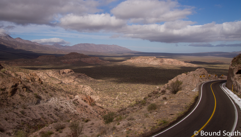
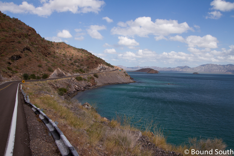
Portions of Highway One along the Sea of Cortes |
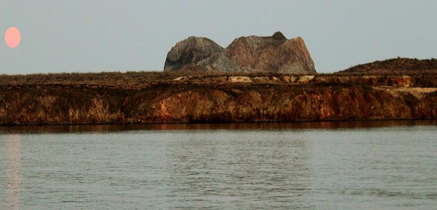
The lower of the two small peninsulas at the lower right is Punta Pulpito, a Pleistocene obsidian dome dated at about 0.5 million years. The dome juts into the Gulf of California (right) in this NASA Landsat image with north to the top and lies east of the southern end of Bahнa Concepciуn (upper left). The Saquicismunde geothermal area lies near the dome, and the larger Los Volcanes geothermal area, which lies along the coast about 5 km south of Punta el Pulpito, contains 18 fumaroles.Pleistocene-fumarolic, last eruption unkniwn, lava dome.a Pleistocene obsidian dome dated at about 0.5 million years that forms a small peninsula along the Gulf of California, east of the southern tip of Bahнa Concepciуn in southern Baja California. The Saquicismunde geothermal area with hydrothermal springs and steaming ground lies close to the dome, and the larger Los Volcanes geothermal area, lying along the coast about 5 km south of Punta el Pъlpito, contains 18 fumaroles along a NW-SE alignment NASA Landsat7 image (worldwind.arc.nasa.gov). http://www.volcano.si.edu/world/volcano.cfm?vnum=1401011A Punta Pъlpito volcano is a lava dome which formed about 500,000 years ago on a small peninsula at the Gulf of California east of the southern tip of Bahia Concepcion. Typical eruption style: effusive. No eruption within 10 KY, no earthquakes. unknown elevation -http://www.volcanodiscovery.com/punta_pulpito.html |
Moonrise at Punta Pulpito |
Punta Pulpito |
Punta Purismo |
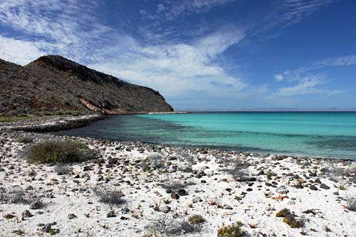
northern tip of the Bay of La Paz in Baja California''s Sea of Cortez |
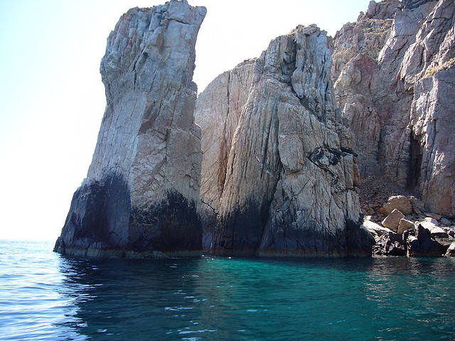
In Southern Baja, near the town of La Paz |
|
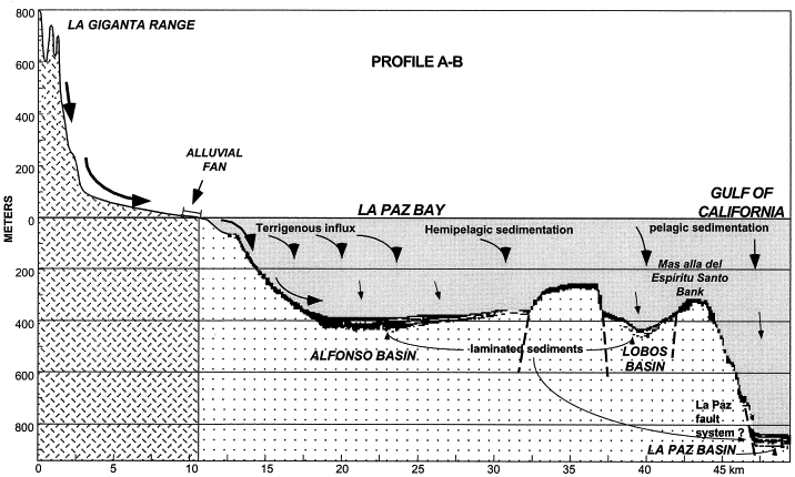
The Baja California peninsula borderland: structural and sedimentological characteristics -http://www.sciencedirect.com/science/article/pii/S003707380100135X Structural and sedimentological data from three oceanographic cruises define the peninsular margin of the Gulf of California as a borderland similar to the California Continental Borderland. Bathymetric and high resolution seismic profiles show some active normal faults with a lateral strike slip component, which are parallel and oblique at low angle to the peninsular coast, and delimit horst and graben structures. Preliminary conclusions are that, active faults are related to the movement of the peninsular block towards the northwest.As part of the opening of the Gulf (circa 6.5 my ago), grabens and half-grabens, separated by highlands, islands and banks have formed. Some of the basins are now inland, such as Santa Rosalia, Loreto and San Jose del Cabo, and are filled with Pliocene and possibly Miocene marine rocks. Other basins are modern shallow bays, like Concepciуn (30 m deep); others are slope basins with a range of depths, such as Alfonso and Cochimie basins at about 400 m; and La Giganta and La Paz basins at 500 and 700 m, respectively.Sedimentation in these basins is varied. Inland basins (Pliocene) are filled with shallow marine sedimentary rocks, clastics and evaporites; Concepciуn is a starved basin filled with some terrigenous, but mainly biogenic sediments; the modern deep basins (Alfonso, La Giganta and La Paz) are filled with terrigenous sediments on their peninsular margin, biogenic if they are limited by islands, and laminated sediments if they are stagnant or have slopes or sills intersecting the oxygen minimum layer of the water column |
La Paz |
La Paz, maps http://navegantecalifornio01.blogspot.com/ |
Mushroom Rock in Bahia Balandra, La Paz |
La Paz |
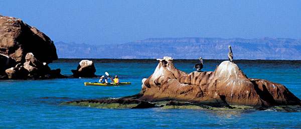
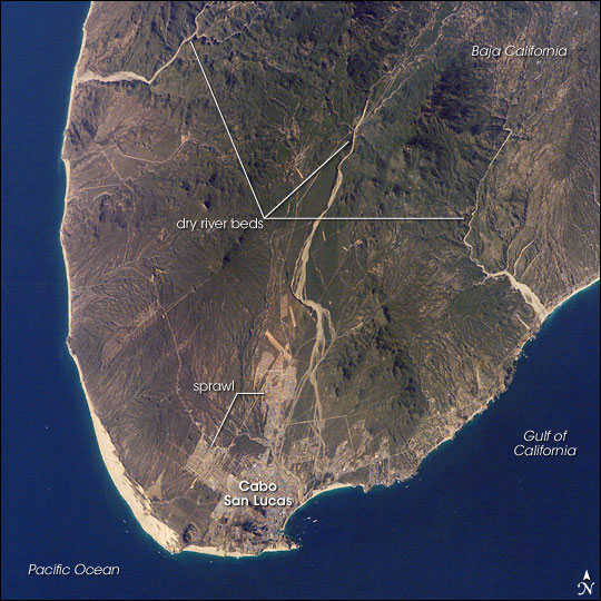
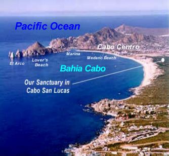
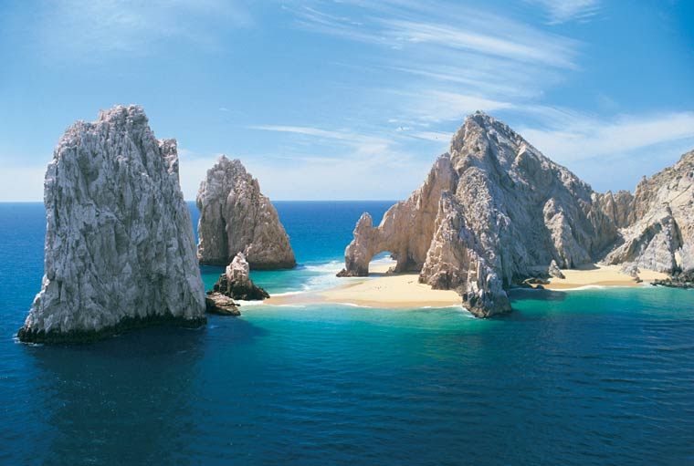
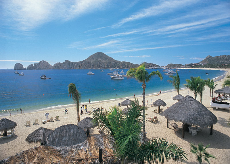
Cabo san lucas |
Cabo san lucas |
Cabo san lucas |
Cabo San Lucas |
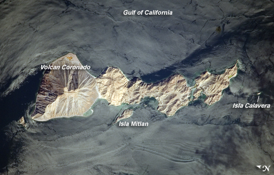
Coronado volcano, Gulf of California, stratovolcano, 440+ m, Typical eruption style: explosive, recent eruptions, no recent earthquakes. Coronado volcano is a small stratovolcano in the Gulf of California. It forms a 2 km wide peninsula at the northern tip of Coronado Island, 3 km off the eastern coast of Baja California in the Canal de los Ballenas. |
Guadalupe shield volcano, 1100m, is a mostly submerged volcano that forms the island of the same name 250 km west off the coast of Baja California. The volcano was built on the old axis of an ancient spreading center and consists of 2 overlapping shields, the southern of which is the older. The younger northern volcano could still be active and has probably erupted during the Holocene. Typical eruption style: effusive. Last eruptions less than 10,000 years ago. No recent earsquakes. Elongated Guadalupe Island lies atop a fossil oceanic ridge crest and rises above the Pacific Ocean surface to an elevation of 1100 m. Chains of cinder cones are located along fissures oriented both NW-SE and NE-SW and lava flows erupted from them overlie both shield volcanoes. The longest of these fissures cuts across the caldera of the northern volcano and extends beyond it to the SE. Other pyroclastic cones were constructed along an arcuate fissure near the southern caldera rim. The shield volcanoes and products of the fissure eruptions form a complete alkali basaltic-to-trachytic series reflecting a transition from submarine to subaerial volcanism. Trachytic lava domes are found within the caldera of the northern shield volcano, and together with very fresh-looking alkali basalt lava flows, form the youngest volcanic rocks on the island. (Source: Smithsonian / GVP volcano information http://en.wikipedia.org/wiki/Guadalupe_Island http://www.volcanodiscovery.com/baja-california.html |
Guadalupe shield volcano |

From http://www.volcanolive.com/mexico.html
Subduction of the Farallon plate beneath northwestern Mexico stalled by 12 Ma when the Pacific-Farallon spreading-ridge approached the subduction zone. Coupling between remnant slab and the overriding North American plate played an important role in the capture of the Baja California (BC) microplate by the Pacific Plate.
Active-source seismic reflection and wide-angle seismic refraction profiles across southwestern BC (24.5ЎгN) are used to image the extent of remnant slab and study its impact on the overriding plate. The hot, buoyant slab detached 40 km landward of the fossil trench. Isostatic rebound following slab detachment uplifted the margin and exposed the Magdalena Shelf to wave-base erosion. Subsequent cooling, subsidence and transtensional opening along the shelf (starting 8 Ma) starved the fossil trench of terrigenous sediment input. Slab detachment and the resultant rebound of the margin provide a mechanism for rapid uplift and exhumation of forearc subduction complexes.
Changes in subduction dynamics, surface deformation, volcanism and widespread tectonic reorganization have been attributed to slab detachment [Dickinson and Snyder, 1979; Liu and Stegman, 2012; Severinghaus and Atwater, 1990]. Between 20ЁC16 Ma, the subducting Farallon Plate fragmented into the Guadalupe and Magdalena oceanic microplates as the Pacific-Farallon ridge approached the trench along the western margin of the modern-day Baja California (BC) peninsula [Atwater and Stock, 1998; Lonsdale, 1991]. Abyssal hill fabric and seafloor magnetic anomalies along the Magdalena Ridge suggest that seafloor spreading ceased by 12 Ma [Lonsdale, 1991].
Subsequent structural reorganization and post-subduction volcanism in Baja California (BC) and mainland Mexico [Ferrari, 2004; Pallares et al., 2007] may be consequences of slab detachment as young, buoyant oceanic lithosphere approached the trench [Burkett and Billen, 2009; Michaud et al., 2006]. Despite these observations, the following remain poorly understood: (1) the modern day architecture of BC continental crust and underlying relic slab, (2) the spatial relationship between post-subduction melts and relic slab geometry, (3) the geologic expression of slab detachment on the overriding plate (e.g., exhumation and erosion), and (4) the relative timing between subduction cessation and onset of transtensional deformation. Based on the integration of geological data with an active-source seismic reflection/refraction transect across the southern BC peninsula, there present new constraints on the two-dimensional crustal/upper mantle architecture of the BC microplate and interpretations for the isostatic response and tectonic reorganization of the BC microplate following slab detachment .
As the Pacific-North American plate boundary transformed from a convergent to translational margin the Farallon oceanic plate fragmented to the west of northwestern Mexico into the Guadalupe and Magdalena microplates [Lonsdale, 1991]. Between 14ЁC12 Ma seafloor spreading and subduction of the Magdalena microplate slowed and ceased [Lonsdale, 1991]. Deformation associated with the evolving plate boundary was distributed between both sides of the BC peninsula, however the timing and kinematics of the deformation are debated [Fletcher et al., 2007; Oskin et al., 2001]. Michaud et al. [2006] proposed that complete capture of the Magdalena plate by the Pacific plate occurred progressively from 12 Ma to 8ЁC7 Ma. Regardless, the total amount of relative displacement between the Pacific and North American plates since 14 Ma is 700 km and transtensional deformation appears to have been focused in the Gulf of California earlier than 6 Ma suggested by Stock and Hodges [1989].
[4] Volcanic rocks emplaced along southern BC record tectonic reorganization from 16 Ma to the present. Early to Middle Miocene calc-alkaline arc volcanism (i.e., Comondú Group; Figure 1) started to wane 15 Ma and ceased by 12 Ma [Umhoefer et al., 2001]. Post-subduction adakites and bajaites (ca. 12 Ma ЁC Holocene) are found on BC between 24ЎгNЁC27ЎгN and 100ЁC250 km inboard of the paleo-trench [Calmus et al., 2011, and references therein]. These rocks have been attributed to slab detachment and melting of young (< 5 m.y. old), subducted oceanic crust. Adakites dated between 6ЁC5 Ma have been sampled near Line 0 on the footwall block of the Santa Margarita Fault [Bonini and Baldwin, 1998] (Figure 1). Their emplacement began at roughly the same time as the onset of dextral transtension along the Magdalena Shelf [Michaud et al., 2006].
http://www.agu.org/journals/gl/gl1209/2011GL050828/index.shtml#Abstract
[11] Although direct age control on shelf stratigraphy is unavailable, there is potential to establish a relative chronostratigraphy for the shelf sediments with the dated material at the toe of the slope [Fletcher et al., 2007; Yeats et al., 1981]. At the drill site, the distal turbidites of the Magdalena Fan are separated from overlying upper mid-Miocene porcelanite and porcelaneous silty claystone by a depositional hiatus [Yeats et al., 1981]. There is a sharp decrease in both deposition rate and supply of terrigenous material above the hiatus. This boundary is traced to the toe of the slope where it appears to separate regionally laminated, low-amplitude Magdalena Fan turbidite layers (14.5ЁC13 Ma) from the overlying high-amplitude and irregular layers of the middle unit (13ЁC8 Ma). At the drill site the BSR is concordant with the hemipelagic beds and approximately delineates the upper boundary of the middle unit. As the BSR is followed landward, the middle unit thickens markedly into the paleotrench, which is consistent with emplacement by gravity flows. The package above the BSR contains irregular bedding and disrupted strata that appear to be confined to a small trough at the base of the slope; farther seaward, the same layers become laminar and have relatively low amplitude. This change in character may record the cut-off of shelf sediment and the transition to fine-grained, gravity flows sourced from failed hemipelagic deposits on the adjacent continental slope.
[12] The high velocities of the sediments (3 km/s) imaged on the shelf beneath the regional unconformity suggests that at least 1 km of overburden has been removed by erosion [Brocher, 2008]. We present the following explanation: the 13ЁC8 Ma sedimentary wedge represent deposits that were shunted off the margin when the shelf was exposed to wave-base erosion. The prograding shelf strata resting above the unconformity (package C) indicate that widespread erosion was followed by subsidence and sequestration of terrigenous sediment on the shelf. Divergent layers within Packages B and A record the opening of transtensional basins on the shelf, leading to further isolation of the paleotrench from terrestrial sediment sources. Sediment deposited above the BSR along the fossil trench shows a dramatic decrease in deposition rate and change in acoustic character. This change appears to be associated with the opening of basins on the shelf, and thus a transition to hemipelagic and locally sourced debris flow deposition along the slope and paleotrench. Correlating shelf packages AЁCC to the post-BSR strata in the trench provides a maximum age of shelf subsidence and transtensional opening along the TAF of 8 Ma.
[13] Based on the seismic evidence for high-velocity oceanic slab beneath the Magdalena Shelf, stratigraphic interpretations on the shelf and toe of the slope, transtensional deformation on the shelf and adakite volcanism on Isla Santa Margarita [Bonini and Baldwin, 1998], we propose that the slab detached near the break in Moho inclination. Although the eastward extent of the high-velocity zone is not resolved due to limited ray coverage in the lower crust and upper mantle, slab reflections and/or other seismic evidence for remnant slab extending below the root of the BC microplate are not observed [Brothers, 2009]. As the dense slab broke away and sank into the mantle, the overriding plate was isostatically uplifted and exposed to wave-base erosion. The age of blueschist exhumation along western BC is poorly constrained, but there is evidence for increased uplift of the subduction complex during the Middle Miocene [Baldwin and Harrison, 1989]. Numerical models of rebound immediately after slab detachment estimate that 2 to 6 km of uplift may occur [Buiter et al., 2002] and geologic evidence in the Apennines, Northern Italy, documents a minimum of 500 m of post-detachment uplift [van der Meulen et al., 1999]. After slab detachment and isostatic rebound, the stalled Magdalena ridge complex cooled, the margin subsided and Package C was deposited on the shelf. Transtension initiated along the TAF and SMF zones created shelf accommodation and trapped terrigenous sediment (packages B and A) and starved the paleotrench from terrestrial sediment sources.
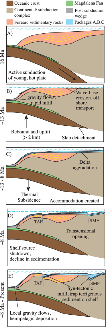
In summary, we propose the following sequence of events beginning at 16 Ma. (1; 16ЁC13 Ma): Subduction slowed and the Magdalena slab became unstable as young, hot lithosphere approached its yield strength, eventually breaking off at a point below the Magdalena Shelf. (2; 13 Ma): Rebound and uplift of the Magdalena Shelf occurred, exposing the margin to wave-base erosion and formation of a regional unconformity. Eroded shelf rock and terrigenous material were initially transported to the deep sea, forming a thick wedge of onlapping strata along the toe of the slope. (3;13ЁC8 Ma): As the stalled ridge complex cooled, the Magdalena Shelf subsided, creating accommodation for fan-delta progradation that predates opening along the TAF (Package-C), although pure strike-slip could go undetected in 2-D seismic profiles. (4;8 MaЁCpresent): The Magdalena microplate became completely welded to the Pacific Plate and motion along the TAF and SMF systems began. Terrigenous sediment was routed away from uplifted footwall blocks and into the incipient shelf basins, further starving the slope of sediment.
[15] The approximately 4 million-year lag between the end of full-rate spreading and the onset of transtension along the Magdalena Shelf could represent a reorganization of the plate boundary as the relic slab gradually became welded to BC [Atwater and Stock, 1998; Bohannon and Parsons, 1995]. In this model, transtensional faulting in the BC forearc occurs much later in time (8 Ma versus 12 Ma) than suggested by Stock and Hodges [1989]. If these faults systems formed 8 Ma and accommodated 3ЁC7 mm/yr of slip since their initiation [Michaud et al., 2011; Plattner et al., 2007], their cumulative displacement would be 24ЁC56 km, in agreement with estimates by Fletcher et al. [2007]. Since 12.3 Ma the total displacement between the Magdalena microplate and North America is 610 km. At least 460 km was accommodated in the southern Gulf of California [Fletcher et al., 2007], which leaves 100 km of unaccounted relative plate motion. Although seafloor magnetic anomalies that post-date 12 Ma are equivocal [Lonsdale, 1991], it is possible that post-subduction spreading and rotation of the Pacific-Magdalena ridge segments accommodated some portion of the missing displacement prior to the onset of transtension on the Magdalena Shelf [Michaud et al., 2006].
[16] High shear wave velocities (50ЁC90 km depth) imaged beneath the BC peninsula to the north of Line 0 may represent remnants of the stalled Magdalena microplate [Wang et al., 2009]. The high velocity anomaly disappears in the vicinity of Line 0 and is replaced by a low velocity anomaly that underlies the Magdalena Shelf and the proposed location of slab detachment. If traction forces along the interface between the slab and overriding plate influenced the rifting process and aided the transfer of BC to the Pacific Plate, one might expect a change in kinematics to the south of Line 0 where the slab is either diminutive or nonexistent. Prior to detachment, westward migration and steepening of the Farallon slab [Umhoefer et al., 2001] may have led to enhanced upwelling and replacement of mantle material that provided additional forces to Ў░pushЎ▒ the BC peninsula toward Pacific plate velocities, thus explaining, in part, how BC may have been Ў░pulledЎ▒ by traction forces between a stump of hot, weak oceanic lithosphere.
Conclusions
[17] This results support a tectonic model for margin reorganization and oceanic slab detachment beneath the western margin of the BC microplate. Slab detachment and the consequent uplift of the overriding plate may be an important mechanism for rapid exhumation and erosion of subduction complexes [e.g., Ring et al., 1999]. Without deep sea drilling and additional lower-crust and upper-mantle seismic imagery below the western margin of BC, the precise timing and location of slab detachment will remain less certain. Based on these combined factors, it appears likely that older, denser slab broke away from its younger, weaker and more buoyant section beneath the Magdalena Shelf near its interface with the overriding continental crust. Subsequent to detachment, basal shear applied to the continental margin of North America by stalled Farallon microplates may have constituted a key influence in the dynamic evolution of the BC microplate and its subsequent capture by the Pacific plate.
http://www.agu.org/journals/gl/gl1209/2011GL050828/index.shtml#sec5
http://en.wikipedia.org/wiki/List_of_volcanoes_in_Mexico
http://en.wikipedia.org/wiki/Category:Volcanism_of_Mexico
http://en.wikipedia.org/wiki/Volcanoes_of_east-central_Baja_California
http://en.wikipedia.org/wiki/List_of_volcanoes_in_Mexico
http://en.wikipedia.org/wiki/Category:Volcanism_of_Mexico
http://en.wikipedia.org/wiki/Baja_California_peninsula
http://www.csus.edu/indiv/h/hausback/PDFs%20of%20Publications/Hausback%201984%20Cenozoic%20Volcanic%20and%20Tectonic%20Evolution%20-%20Baja.pdf - Cenozioc Volcanos and tectonic evolution of Baja california sur, Mexico
http://www.volcanodiscovery.com/baja-california.html
http://www.volcanolive.com/mexico.html
http://www.volcanodiscovery.com/baja-california.html
Cenozioc Volcanos and tectonic evolution of Baja california sur, Mexico
The separation and emigration of the Lower California Peninsula (Baja California), the birth of the Gulf of California, and the "stretching" of Sonora in a direction East ЁC West
Volcanoes of east-central Baja California
Offshore Islands