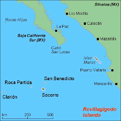
 | Volcanoes. Baja California |
|
A possible submarine eruption occurred on or before 20 July 1953 off the western coast of Baja California from an unknown submarine volcano. The report came from sailors on fishing boats who observed great numbers of dead fish and mud bubbling up at sea 2 km from San Cristobal Island. The captain of the Scripps Institution of Oceanography vessel "Horizon" reported similar phenomena at another point near the island of Cedros, not far from San Cristobal Bay. The origin of these events is uncertain- http://www.volcanodiscovery.com/mexico/unnamed.html |
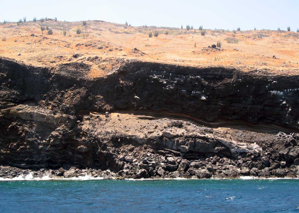
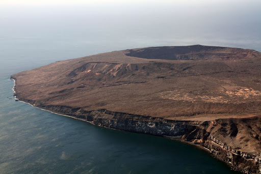
Isla Tortuga nature - http://seabaja.com/news/?cat=8 |
A wider view showing the thin layer of soil suitable for plant growth atop the unstable volcanic island |
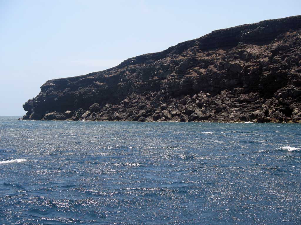
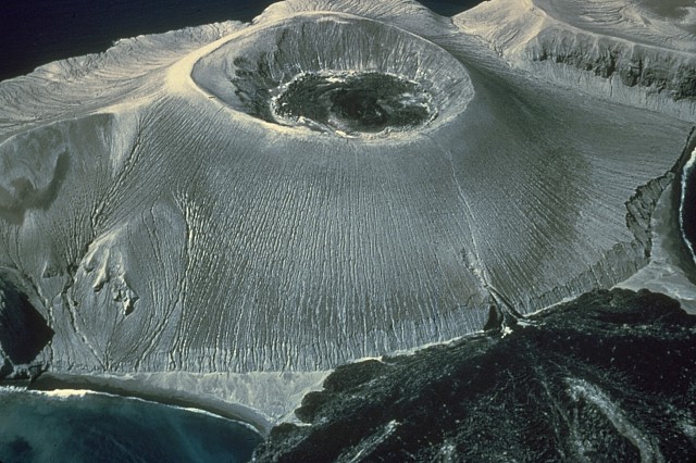
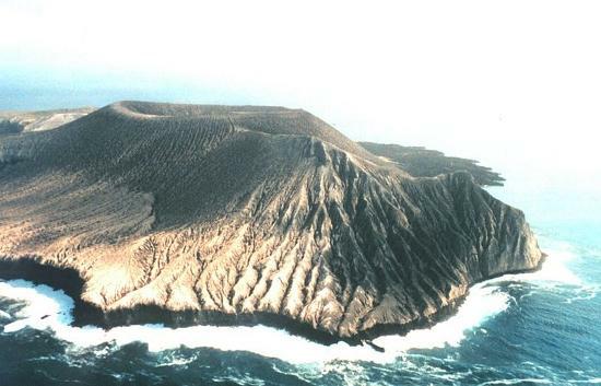
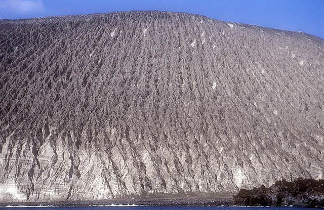
Isla Tortuga volcano is a young basaltic shield volcano that forms the small 4 km wide island of the same name located 40 km off the Baja coast in the Gulf of California. The volcano has a circular summit caldera, about 100 m deep, containing a frozen lava and several cinder cones from probably relatively recent eruptions. Young lava flows cover most of the volcano''s flanks. At present, there is fumarolic activity. The shield volcano was constructed during 2 north-migrating periods of activity that began with submarine eruptions and included formation of a circular tuff-ring complex enclosing the caldera.The sides of a small volcanic horst in the center of the caldera display lava flows overlying a 2-m-thick halite bed, formed when sea water filled the caldera, creating an evaporite basin. Typical eruption style: effusive, eruptions less than 10,000 years ago, no recent earthquakes - http://www.volcanodiscovery.com/baja-california.html |
Isla Tortuga shield volcano |
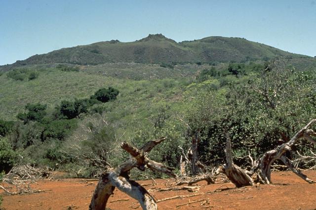
Punta Pulpito volcano is a lava dome which formed about 500,000 years ago on a small peninsula at the Gulf of California east of the southern tip of Bahнa Concepcion. It is included in the catalogue of potentially active volcanoes because it still has an active geothermal system with hot springs and steaming ground. One active geothermal field is known as the Saquicismunde geothermal area, and the larger Los Volcanes geothermal area, located along the coast about 5 km south of Punta el Pulpito, contains 18 fumaroles along a NW-SE alignment.no eruptions within the past 10,000 years, no earthquakes. http://www.volcanodiscovery.com/punta_pulpito.html |
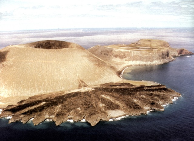
Barcena volcano Cinder cones 332 m, Typical eruption style: Explosive, no recent earthquakes, forms the southern part and most significant feature of Isla San Benedicto, the 3rd largest and north-easternmost of the 4 Islas Revillagigedo islands about 350 km south of Cabo San Lucas, Baja California. The volcano formed by eruptions during 1952-53 and consists in a 700 m wide and 330 m high tuff cone with a circular crater and a spectacular lava delta on the east side formed by a trachytic lava flow that breached the crater and entered the sea. The eruption was the first historic eruption witnessed in the eastern Pacific Ocean. San Benedicto island is a 4.5 km long NE-SW elongated island composed of several volcanic vents that have migrated SW over time. Pleistocene trachytic lava domes form the northern part, and historical Barcena volcano and Montнculo Cinerнtico, a smaller tephra cone eceding Bбrcena and largely covered by it, form the southern tip of the island. Montнculo Cineritico may also have been constructed during the past few hundred years and formed the high point of the island prior to the formation of Bбrcena. The formation of Bбrcena began in August 1952 and was accompanied by strong explosive eruptions and pyroclastic flows including radial base surges. The eruption concluded the following year with the emplacement of two small lava domes in the crater and extrusion of a prominent coastal lava delta at the SE base of the cone. Source: GVP, Smithsonian Institution http://www.volcanodiscovery.com/barcena.html |
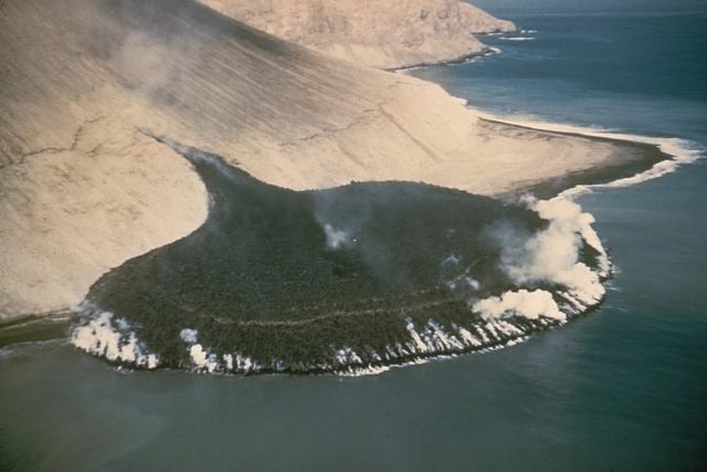
1952-53 eruption Barcena volcano was born during ''s only historic eruption which began on 1 August 1952, from the El Boquerуn vent. The eruption began with powerful vulcanian explosions creating base surges, which were witnessed from a nearby fishing boat. Large amounts of ash and pumice quickly built a new cinder cone built at the southern end of the island. In the later stage of the eruption, a viscous lava dome and lava flow emerged from the crater in December and flew to the east and created a spectacular, perfectly half-circular lava delta, known as the "Delta Lavico". A steaming lava flow issuing from a fissure on the SE flank of Bбrcena volcano, in the Revillagigedo Islands west of Mйxico, forms a peninsula about 300 m wide that extends about 230 m out to sea. This photo from the SE on December 11, 1952 was taken only 3 days after the beginning of lava effusion. By the time the eruption ended in February 1953 the lava delta had extended the shoreline by 700 m |
The dramatic Delta Lavico flow forms a peninsula on the SE flank of Volcбn Bбrcena at the southern end of San Benedicto Island. The tuff cone and lava flow were formed during the 1952-53 eruption. The Barcena tuff cone now marks the high point of the island. The flat-topped cone at the right is Crater Herrera, a trachytic lava dome capped by a smooth-floored crater. Another lava dome, Roca Challenger, forms the northern tip of the island beyond Crater Herrera -http://www.volcano.si.edu/world/volcano.cfm?vnum=1401-02=&volpage=photos |
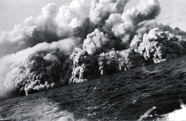
The birth of Barcena is described in detail by A.F. Richards (1959) who collected various eyewitness accounts. The birth of the volcano was witnessed by the crew of the clipper M/V Challenger. It began suddenly at 07:45 on 1 August 1952, when the crew aboard the fishing boat, at that time about 2 miles west of Punta Norte, saw a sudden pencil-like emission of white steam. A few minutes later, a dark gray-black column of ash was observed, and violent explosions started, and the crew witnessed a base surge: "A few minutes later, the steam column had largely dissipated and dark gray-black or cement-colored column of ash and steam shot skyward. It did not appear incandescent. Almost immediately, the eruption cloud began to spread laterally at the base." The surge was seen climbing over small hills and reached about 2 km lateral distance. In the meanwhile, a dense cauliflower eruption column had reached about 4300-4500 ft altitude and further rose to 6700 ft, and spread laterally about 11,000 ft. The vessel retreated at full speed from the eruption to avoid being hit by bombs, which could be seen falling into the sea southwest of Monticulo Cineritico: "The ocean, previously clear and blue, became turbid, due to suspended ejecta, and remained murky." Although not hit by the main part of the surge (it would have been destroyed), "several inches of powdery dust, ash and cinders (up to about 12 mm in diameter) fell upon the deck of the Challenger." Ejecta quickly filled the valley between Herrera crater and Montнculo Cinerнtico, and by 14 August, the eruption had formed a new cone, Bбrcena, some 300 m (over 1000 ft) high. After some months with little activity, a second series of eruptions, more effusive, began on 1 November and a viscous lava dome started to form in the crater of Barcena. On 8 December, the magma broke through a notch in the cone''s southeastern side and started to flow into the sea, where it formed a semi-circular cake-like flat lava delta, the "Delta Lavico". The activity continued to about 24 February 1953 and by 9 March, all activity apart from fumaroles in the crater and near its base had stopped. http://www.volcanodiscovery.com/barcena-eruptions.html#er791 |
An aerial view from the SE shows the Bбrcena tuff cone, constructed during an eruption in the Revillagigedo Islands off the western coast of Mйxico during 1952-53. The 700-m-wide crater is partially filled by small lava domes, and a fissure on the flank of the cone fed the black lava delta at the lower right. The tuff cone was constructed to a height of about 330 m from near sea level within the first few weeks of an eruption that began on August 1. The first lava dome had formed by mid-September, and flank lava effusion began on December 8 http://www.volcano.si.edu/world/volcano.cfm?vnum=1401-02=&volpage=photos http://www.volcano.si.edu/world/volcano.cfm?vnum=1401-02=&volpage=photos&photo=036037 |
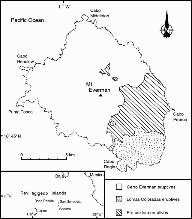
The island of San Benedicto was wiped out by volcanic eruption on August 1, 1952 but has since recovered. Most all of the native plants on this island are also found on Clariµn. Most of the plants and animals seem to have come from mainland populations. Plants are most often from Baja California and reptiles seem to be from the Sonora-Sinaloa area. Still pristine in 1956, except for sheep introduced in 1869, the islands have since seen a lot of non-native introductions including feral cats. This has caused pressure on some native species that are now threatened with extinction. Socorro volcano shield volcano 1050 m forms the SE-most of the Revillagigedo Islands south of Baja California. It is the summit of a very active, large, mostly submarine basaltic shield volcano. Its summit is capped by a largely buried, 4.5 x 3.8-km-wide summit caldera. A submarine eruption occurred 3 km west of Socorro island during 1993-94, which manifested itself by steaming lava balloons rising to the surface. A large tephra cone and lava dome complex, Cerro Evermann, forms the 1050-m-high summit of the volcano, and along with other cones and vents, fills much of the Pleistocene caldera. Rhyolitic lava domes have been constructed along flank rifts oriented to the north, west, and SE, and silicic lava flows from summit and flank vents have reached the coast and created an extremely irregular shoreline. Late-stage basaltic eruptions produced cones and flows near the coast. Only minor explosive activity, some of which is of uncertain validity, has occurred from flank vents in historical time dating back to the 19th century. In 1951 a brief phreatic eruption ejected blocks, and the gas column reached 1200 m elevation. A submarine eruption occurred during 1993-94 from a vent 3 km west of the island during which large scoriaceous blocks up to 5 m in size floated to the surface without associated explosive activity. http://www.volcanodiscovery.com/socorro.html |
Socorro island volcano. Socorro Island is located ~716 km W of Manzanillo, Colima, and 480 km S of the tip of Baja California. Tectonically, it is located within a segment of the southernmost region of the East Pacific Rise, S of the Riverra Fracture Zone. Eruptions have been reported in 1848, 1896, 1905, and 22 May 1951, but there are no clear details about the eruptions or their effects. The island is a compositionally diverse volcanic complex that rises about 4,000 m from the surrounding ocean floor. Based on recent 40Ar/39Ar dating, the surface is estimated to be 540 Ka old. The youngest reported age, from a lava flow on the S side of the island, is about 15 Ka, but probably does not represent the youngest unit. There are about 60 men, stationed at the Mexican National Navy base, living on the island. http://www.volcano.si.edu/world/volcano.cfm?vnum=1401-021&volpage=var |
Cerro Evermann is a large tephra cone and lava dome complex that forms the 1050-m-high summit of Socorro volcano. It and other pyroclastic cones and lava domes largely fill a 4.5 x 3.8 km wide caldera at the summit of the Socorro shield volcano. Historical eruptions at Socorro have been restricted to flank ventsPhoto by Steve Nelson, 1989 |
The southern flank of Socorro volcano is underlain by rocks of three distinct origins. On the lower flanks are alkaline basaltic rocks of the Lomas Coloradas unit mostly erupted between about 150,000 and 70,000 years ago. The middle flanks contain precaldera and syncaldera trachytic and rhyolitic ashflow deposits erupted between about 540,000 and 370,000 years ago. The summit region, including Cerro Evermann (center horizon), consists of silicic peralkaline rocks erupted between about 180,000 to at least 15,000 years ago.Photo by Martha Marin, 1998 (Mexican Navy) |
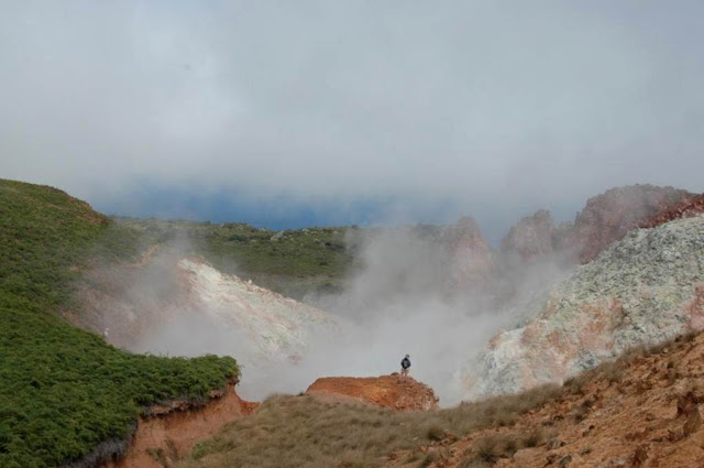
Volcan Evermann, in Isla del Socorro -http://es.wikipedia.org/wiki/Volc%C3%A1n_Evermann Obsidian lava domes and flows of soda rhyolitic and trachytic composition have filled most of the summit craters. Cerro Evermann lies within a 4.5 x 3.8-km-wide Pleistocene caldera that formed about 370,000 years ago and has been largely filled by post-caldera eruptions. The caldera rim is exposed at about 600 m elevation on the south and east sides of Cerro Evermann, where it forms a low, steep scarp 20-50 m high. Extensive hydrothermal alteration is visible in valley walls of a thermal area near the summit of Cerro Evermann. Steam rises from fumaroles in this 1998 view. The largest fumarolic vent is located at the head of a large barranca NE of the summit. During a 1957 visit by Mooser and Bryan, temperatures of 65-97¯ C were measured. Similar temperatures ranging from 61-101¯ C were measured in 1993 |
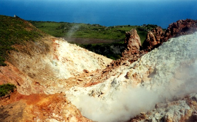
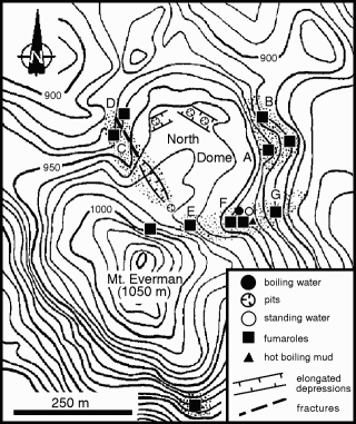
Fumarolic areas at Socorro are concentrated near the summit of Cerro Evermann. They occur on all sides of North Dome, a young lava dome just north of the summit of 1050-m-high Cerro Evermann. The most extensive hydrothermal alteration is located in areas on the east, west, and SW sides of North Dome.Photo by Martha Marin, 1998 (Mexican Navy).The summit fumarole area of Everman volcano -the summit lava dome complex, composed of abundant obsidian and other less vitric lavas, did not contain any fumaroles. However, below the summit to the NNE and NW, there are fumaroles at the base of a relatively young lava dome (figure 3), which appears to be the most recent feature in the summit area. The younger dome, which has obsidian margins, appears to have filled an older crater in a depression about 100 m below the summit to the N. The most active area is on the SE side of the N dome along an apparent zone of weakness with cracks to 1 m deep and 1 m wide. This zone includes areas of vapor, boiling water or mud, clay alteration, sulfates, and sulfur encrustations. The largest and most continuously active fumarole produced a hissing sound. Water samples from a hotspring near fumarole F were obtained for analysis. An older dome SE of the summit also has some very small fumaroles. Overall, vapor emissions in the summit area do not seem uncommon for an active volcano. Precursors were first recorded on 19 January, when an unusual clustering of randomly distributed impulsive hydroacoustic signals (T-phases) was observed on recordings from SOFAR channel hydrophones located near the island of Oahu, Hawaii. The T-phases were accompanied by elevated levels of background noise. Activity intensified at about 1000 GMT, and lasted approximately 1 hour. Based on the strongest phases recorded in Hawaii and at the LDG in Tahiti, the source was located near Socorro Island. Seismicity was felt by Mexican naval authorities on the island beginning on 16 January. A portable MQ-800 seismometer was installed on 4 February at the naval base on the island. http://www.volcano.si.edu/world/volcano.cfm?vnum=1401-021&volpage=var |
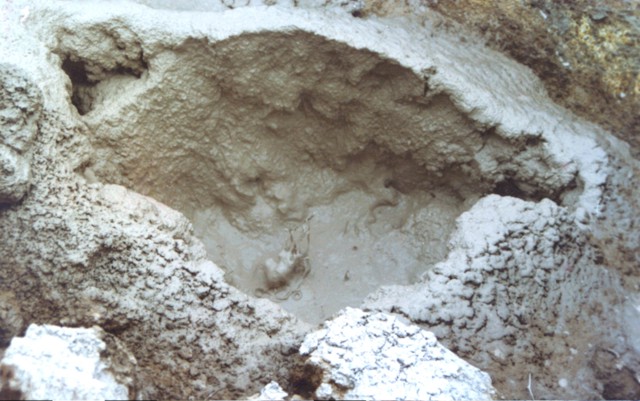
Mudpots are found at hydrothermal areas near the summit of Cerro Evermann. Fumaroles appear at the base of a relatively young lava dome, which is apparently the youngest feature in the summit area. This dome has obsidian margins and appears to have filled an older crater in a depression about 100 m below the summit to the north. The most active area is on the SE side of the north dome and includes areas of vapor, boiling water or mud, clay alteration, sulfates, and sulfur encrustations. Photo by Martha Marin, 1998 (Mexican Navy). |
Location map and general geologic map of Socorro Island showing three major eruptive units (from Bryan, 1966 and 1976). |
Topographic map of the summit of Everman volcano, Socorro Island, with location of major monitored fumaroles, and major structural features of the N lava dome. Light stipling indicates areas with intense fumarolic activity and hydrothermal alteration.http://www.volcano.si.edu/world/volcano.cfm?vnum=1401-021&volpage=var |
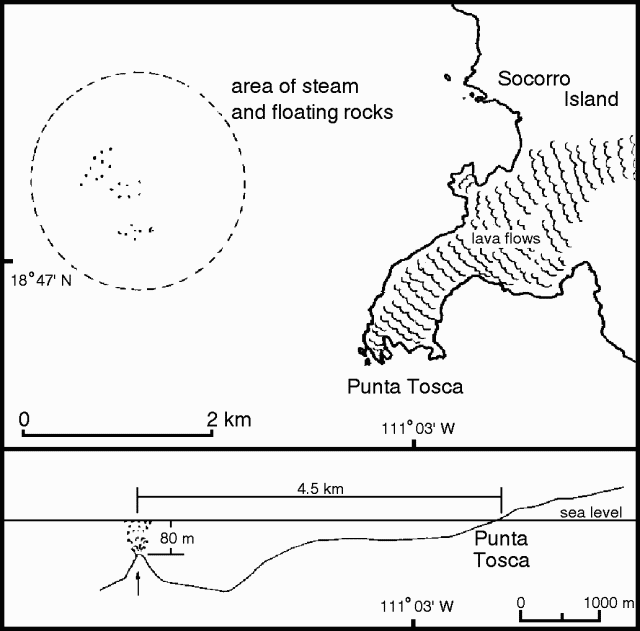
Sketch map and interpretive cross-section of the SW part of Socorro Island with location of submarine activity W of Punta Tosca. Courtesy of Ignacio Galindo -http://www.volcano.si.edu/world/volcano.cfm?vnum=1401-021&volpage=var |
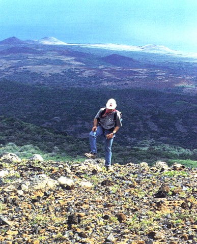
The Lomas Coloradas pyroclastic cones along the SW coast of Socorro appear in the background behind a geologist near the summit of Cerro Evermann. A brief phreatic eruption apparently occurred from a cinder cone west of the Lomas Coloradas on May 22, 1951, witnessed from a yacht anchored offshore at Caleta Binner. During a 5-10 minute period, a plume sequentially red, black, and then white rose a short distance above the cone, and bombs or blocks fell around the cone. The plume eventually reached a height of about 1200 m Photo by Hugo Delgado-Granados http://www.volcano.si.edu/world/volcano.cfm?vnum=1401-021&volpage=photos |
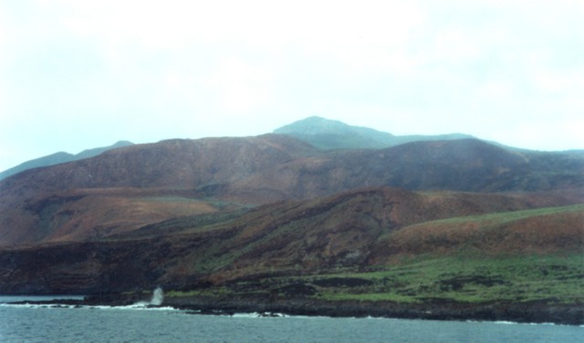
The northern, western, and southern flanks of Socorro volcano are dominated by silicic peralkaline lava domes and flows, which cover about 80% of the surface of the island. This view shows Cerro Evermann from the SW coast. Trachytic and rhyolitic lava flows from summit and flank vents extend into the sea and have produced a very irregular shoreline, with the distal portions of lava flows forming numerous small peninsulas |
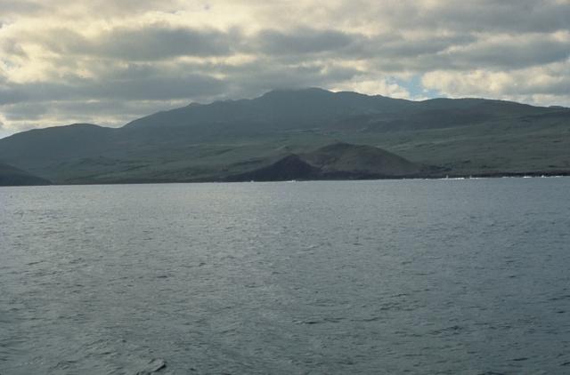
Socorro Island is the summit of a massive, predominantly submarine shield volcano that is capped by a largely buried, 4.5-km-wide summit caldera. Cerro Evermann (center), which forms the 1050-m-high summit of the volcano, is seen here from the south. Mild fumarolic activity continues at the summit lava dome complex. Rhyolitic lava domes have also been constructed along flank rifts, and silicic lava flows have reached the coast. Historical eruptions have been restricted to flank vents, including a submarine vent west of Socorro during 1993-94.Photo by Steve Nelson, 1989 (Tulane University).http://www.volcano.si.edu/world/volcano.cfm?vnum=1401-021&volpage=photos A pyroclastic cone lies along the SSE coast of Socorro Island, east of Cabo Rule (also known as Cabo Regla). The peak on the center horizon is Cerro Evermann, the high point of the island. Basaltic cones and lava flows of the Lomas Coloradas formation blanket the southern tip of the island. Although 80% of the surface of the island is covered by silicic post-caldera peralkaline lava domes and flows and few pre-caldera rocks are exposed, the bulk of the Socorro shield volcano is considered to be composed of basaltic rocks.Photo by Martha Marin, 1998 (Mexican Navy).-http://www.volcano.si.edu/world/volcano.cfm?vnum=1401-021&volpage=photos |
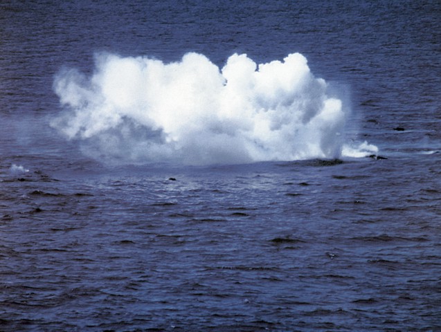
During a submarine eruption first observed on January 29, 1993, small explosions were produced as floating hot rocks fractured and their hot interiors came in contact with sea water. Large blocks of dark-gray, highly-vesiculated basalt up to 5 m in diameter rose to the surface. During individual pulses at irregular intervals, tens of blocks accompanied by effervescent bubbles could be observed rising buoyantly. The blocks emitted loud hissing and crackling noises from thermal expansion prior to breaking up into smaller pieces and sinking.http://www.volcano.si.edu/world/volcano.cfm?vnum=1401-021&volpage=photos Photo by Hugo Delgado-Granados, 1993 Eruptive activity at Socorro Island was first observed at 1745 aboard the "Mystique." When the boat approached a steam column, they observed hot, dark-colored rocks 1-3 m across breaking the surface in an area of 50 m2. Depending on the specific block, there was production of hissing noises, steam, jets of white vapor several meters high, violent fracturing, or fragmentation that sent clasts to 50 m height. No explosive activity or volcanic plume was observed. Depending on vesicularity, blocks either sank or floated; floating rocks covered an area of ~6,000 m2 . Depth soundings gave depths of 138-149 m in an area where a large number of gas bubbles were being generated, presumably by degassing of rising lava clasts. Another depth sounding recorded a depth of 519 m. Juvenile material collected by Mystique divers is described by geologists as black to greenish, semi-translucent, highly vesiculated glass with vesicles up to 5-10 cm in diameter and abundant large (10-15 mm) gray tabular plagioclase phenocrysts.Activity observed by geologists had a radius of about 1 km, about 3.14 km from Punta Tosca and 4.63 km from Cape Henslow on Socorro Island. Water depth, determined by echo-sounding, was 80 m about 200 m SE from the most active area, and rapidly increased to more than 200 m travelling E towards the island. Although the data is only an approximation due to the difficulty of approaching the vent area, a sharp rise in the ocean-floor topography below the most active area is indicated. Very hot scoriaceous lava blocks, ranging in size from several centimeters to 2-3 m, were observed quickly rising to the surface and producing activity similar to that described earlier. Blocks then either floated away or sank, with some being propelled along the surface by steam and effervescence. The vent area was difficult to precisely locate because of strong wind and waves causing the blocks to drift. Most of the time, three distinct and separate areas were observed, somewhat aligned, where the majority of lava fragments were rising. Seawater temperature was normal, but a light sulfurous odor was detected. A helicopter inspection from 1815-1835 observed an accumulation of blocks below the surface from which large (up to 5 m) blocks detached and rose to the surface. Some type of spine from which blocks were being released was confirmed by an overflight about 15 m above the surface. see http://www.volcano.si.edu/world/volcano.cfm?vnum=1401-021&volpage=var |

http://www.volcanolive.com/mexico.html
Subduction of the Farallon plate beneath northwestern Mexico stalled by 12 Ma when the Pacific-Farallon spreading-ridge approached the subduction zone. Coupling between remnant slab and the overriding North American plate played an important role in the capture of the Baja California (BC) microplate by the Pacific Plate. Active-source seismic reflection and wide-angle seismic refraction profiles across southwestern BC (∼24.5¯N) are used to image the extent of remnant slab and study its impact on the overriding plate. We infer that the hot, buoyant slab detached ∼40 km landward of the fossil trench. Isostatic rebound following slab detachment uplifted the margin and exposed the Magdalena Shelf to wave-base erosion. Subsequent cooling, subsidence and transtensional opening along the shelf (starting ∼8 Ma) starved the fossil trench of terrigenous sediment input. Slab detachment and the resultant rebound of the margin provide a mechanism for rapid uplift and exhumation of forearc subduction complexes.
Changes in subduction dynamics, surface deformation, volcanism and widespread tectonic reorganization have been attributed to slab detachment [Dickinson and Snyder, 1979; Liu and Stegman, 2012; Severinghaus and Atwater, 1990]. Between 2016 Ma, the subducting Farallon Plate fragmented into the Guadalupe and Magdalena oceanic microplates as the Pacific-Farallon ridge approached the trench along the western margin of the modern-day Baja California (BC) peninsula [Atwater and Stock, 1998; Lonsdale, 1991]. Abyssal hill fabric and seafloor magnetic anomalies along the Magdalena Ridge suggest that seafloor spreading ceased by 12 Ma [Lonsdale, 1991]. Subsequent structural reorganization and post-subduction volcanism in Baja California (BC) and mainland Mexico [Ferrari, 2004; Pallares et al., 2007] may be consequences of slab detachment as young, buoyant oceanic lithosphere approached the trench [Burkett and Billen, 2009; Michaud et al., 2006]. Despite these observations, the following remain poorly understood: (1) the modern day architecture of BC continental crust and underlying relic slab, (2) the spatial relationship between post-subduction melts and relic slab geometry, (3) the geologic expression of slab detachment on the overriding plate (e.g., exhumation and erosion), and (4) the relative timing between subduction cessation and onset of transtensional deformation. Based on the integration of geological data with an active-source seismic reflection/refraction transect across the southern BC peninsula (Figure 1), we present new constraints on the two-dimensional crustal/upper mantle architecture of the BC microplate and interpretations for the isostatic response and tectonic reorganization of the BC microplate following slab detachment
As the Pacific-North American plate boundary transformed from a convergent to translational margin the Farallon oceanic plate fragmented to the west of northwestern Mexico into the Guadalupe and Magdalena microplates [Lonsdale, 1991]. Between 1412 Ma seafloor spreading and subduction of the Magdalena microplate slowed and ceased [Lonsdale, 1991]. Deformation associated with the evolving plate boundary was distributed between both sides of the BC peninsula, however the timing and kinematics of the deformation are debated [Fletcher et al., 2007; Oskin et al., 2001]. Michaud et al. [2006] proposed that complete capture of the Magdalena plate by the Pacific plate occurred progressively from 12 Ma to ∼87 Ma. Regardless, the total amount of relative displacement between the Pacific and North American plates since 14 Ma is ∼700 km and transtensional deformation appears to have been focused in the Gulf of California earlier than ∼6 Ma suggested by Stock and Hodges [1989].
[4] Volcanic rocks emplaced along southern BC record tectonic reorganization from ∼16 Ma to the present. Early to Middle Miocene calc-alkaline arc volcanism (i.e., Comondú Group; Figure 1) started to wane ∼15 Ma and ceased by ∼12 Ma [Umhoefer et al., 2001]. Post-subduction adakites and bajaites (ca. 12 Ma Holocene) are found on BC between 24¯N27¯N and ∼100250 km inboard of the paleo-trench [Calmus et al., 2011, and references therein]. These rocks have been attributed to slab detachment and melting of young (< 5 m.y. old), subducted oceanic crust. Adakites dated between 65 Ma have been sampled near Line 0 on the footwall block of the Santa Margarita Fault [Bonini and Baldwin, 1998] (Figure 1). Their emplacement began at roughly the same time as the onset of dextral transtension along the Magdalena Shelf [Michaud et al., 2006].
http://www.agu.org/journals/gl/gl1209/2011GL050828/index.shtml#Abstract
Discussion
[11] Although direct age control on shelf stratigraphy is unavailable, there is potential to establish a relative chronostratigraphy for the shelf sediments with the dated material at the toe of the slope [Fletcher et al., 2007; Yeats et al., 1981]. At the drill site, the distal turbidites of the Magdalena Fan are separated from overlying upper mid-Miocene porcelanite and porcelaneous silty claystone by a depositional hiatus [Yeats et al., 1981]. There is a sharp decrease in both deposition rate and supply of terrigenous material above the hiatus. This boundary is traced to the toe of the slope where it appears to separate regionally laminated, low-amplitude Magdalena Fan turbidite layers (14.513 Ma) from the overlying high-amplitude and irregular layers of the middle unit (138 Ma; Figures 2a and S2). At the drill site the BSR is concordant with the hemipelagic beds and approximately delineates the upper boundary of the middle unit. As the BSR is followed landward, the middle unit thickens markedly into the paleotrench, which is consistent with emplacement by gravity flows (Figures 2b and S2). The package above the BSR contains irregular bedding and disrupted strata that appear to be confined to a small trough at the base of the slope; farther seaward, the same layers become laminar and have relatively low amplitude. This change in character may record the cut-off of shelf sediment and the transition to fine-grained, gravity flows sourced from failed hemipelagic deposits on the adjacent continental slope.
[12] The high velocities of the sediments (∼3 km/s; Figures 3b and 3c) imaged on the shelf beneath the regional unconformity suggests that at least 1 km of overburden has been removed by erosion [Brocher, 2008]. We present the following explanation: the 138 Ma sedimentary wedge (Figure 2b) represent deposits that were shunted off the margin when the shelf was exposed to wave-base erosion. The prograding shelf strata resting above the unconformity (package − C) indicate that widespread erosion was followed by subsidence and sequestration of terrigenous sediment on the shelf. Divergent layers within Packages B and A (Figure 2c) record the opening of transtensional basins on the shelf, leading to further isolation of the paleotrench from terrestrial sediment sources. Sediment deposited above the BSR along the fossil trench shows a dramatic decrease in deposition rate and change in acoustic character. This change appears to be associated with the opening of basins on the shelf, and thus a transition to hemipelagic and locally sourced debris flow deposition along the slope and paleotrench. Correlating shelf packages AC to the post-BSR strata in the trench provides a maximum age of shelf subsidence and transtensional opening along the TAF of ∼8 Ma.
[13] Based on the seismic evidence for high-velocity oceanic slab beneath the Magdalena Shelf, stratigraphic interpretations on the shelf and toe of the slope, transtensional deformation on the shelf and adakite volcanism on Isla Santa Margarita [Bonini and Baldwin, 1998], we propose that the slab detached near the break in Moho inclination (Figures 3 and 4). Although the eastward extent of the high-velocity zone is not resolved due to limited ray coverage in the lower crust and upper mantle, slab reflections and/or other seismic evidence for remnant slab extending below the root of the BC microplate are not observed [Brothers, 2009]. As the dense slab broke away and sank into the mantle, the overriding plate was isostatically uplifted and exposed to wave-base erosion. The age of blueschist exhumation along western BC is poorly constrained, but there is evidence for increased uplift of the subduction complex during the Middle Miocene [Baldwin and Harrison, 1989]. Numerical models of rebound immediately after slab detachment estimate that 2 to 6 km of uplift may occur [Buiter et al., 2002] and geologic evidence in the Apennines, Northern Italy, documents a minimum of 500 m of post-detachment uplift [van der Meulen et al., 1999]. After slab detachment and isostatic rebound, the stalled Magdalena ridge complex cooled, the margin subsided and Package C was deposited on the shelf. Transtension initiated along the TAF and SMF zones created shelf accommodation and trapped terrigenous sediment (packages B and A) and starved the paleotrench from terrestrial sediment sources.
In summary, we propose the following sequence of events beginning at ∼16 Ma. (1; ∼1613 Ma): Subduction slowed and the Magdalena slab became unstable as young, hot lithosphere approached its yield strength, eventually breaking off at a point below the Magdalena Shelf (Figures 4a and 4b). (2; ∼13 Ma): Rebound and uplift of the Magdalena Shelf occurred, exposing the margin to wave-base erosion and formation of a regional unconformity. Eroded shelf rock and terrigenous material were initially transported to the deep sea, forming a thick wedge of onlapping strata along the toe of the slope. (3; ∼138 Ma): As the stalled ridge complex cooled, the Magdalena Shelf subsided, creating accommodation for fan-delta progradation that predates opening along the TAF (Package-C; Figure 4c), although pure strike-slip could go undetected in 2-D seismic profiles. (4; ∼8 Mapresent): The Magdalena microplate became completely welded to the Pacific Plate and motion along the TAF and SMF systems began (Figure 4d). Terrigenous sediment was routed away from uplifted footwall blocks and into the incipient shelf basins, further starving the slope of sediment (Figure 4e).
[15] The approximately 4 million-year lag between the end of full-rate spreading and the onset of transtension along the Magdalena Shelf could represent a reorganization of the plate boundary as the relic slab gradually became welded to BC [Atwater and Stock, 1998; Bohannon and Parsons, 1995]. In this model, transtensional faulting in the BC forearc occurs much later in time (8 Ma versus 12 Ma) than suggested by Stock and Hodges [1989]. If these faults systems formed ∼8 Ma and accommodated 37 mm/yr of slip since their initiation [Michaud et al., 2011; Plattner et al., 2007], their cumulative displacement would be 2456 km, in agreement with estimates by Fletcher et al. [2007]. Since 12.3 Ma the total displacement between the Magdalena microplate and North America is ∼610 km. At least 460 km was accommodated in the southern Gulf of California [Fletcher et al., 2007], which leaves ∼100 km of unaccounted relative plate motion. Although seafloor magnetic anomalies that post-date 12 Ma are equivocal [Lonsdale, 1991], it is possible that post-subduction spreading and rotation of the Pacific-Magdalena ridge segments accommodated some portion of the missing displacement prior to the onset of transtension on the Magdalena Shelf [Michaud et al., 2006].
[16] High shear wave velocities (5090 km depth) imaged beneath the BC peninsula to the north of Line 0 may represent remnants of the stalled Magdalena microplate [Wang et al., 2009]. The high velocity anomaly disappears in the vicinity of Line 0 and is replaced by a low velocity anomaly that underlies the Magdalena Shelf and the proposed location of slab detachment. If traction forces along the interface between the slab and overriding plate influenced the rifting process and aided the transfer of BC to the Pacific Plate, one might expect a change in kinematics to the south of Line 0 where the slab is either diminutive or nonexistent. Prior to detachment, westward migration and steepening of the Farallon slab [Umhoefer et al., 2001] may have led to enhanced upwelling and replacement of mantle material that provided additional forces to push the BC peninsula toward Pacific plate velocities, thus explaining, in part, how BC may have been pulled by traction forces between a stump of hot, weak oceanic lithosphere.
6. Conclusions
[17] Our results support a tectonic model for margin reorganization and oceanic slab detachment beneath the western margin of the BC microplate. Slab detachment and the consequent uplift of the overriding plate may be an important mechanism for rapid exhumation and erosion of subduction complexes [e.g., Ring et al., 1999]. Without deep sea drilling and additional lower-crust and upper-mantle seismic imagery below the western margin of BC, the precise timing and location of slab detachment will remain less certain. Based on these combined factors, it appears likely that older, denser slab broke away from its younger, weaker and more buoyant section beneath the Magdalena Shelf near its interface with the overriding continental crust. Subsequent to detachment, basal shear applied to the continental margin of North America by stalled Farallon microplates may have constituted a key influence in the dynamic evolution of the BC microplate and its subsequent capture by the Pacific plate.
http://www.agu.org/journals/gl/gl1209/2011GL050828/index.shtml#sec5