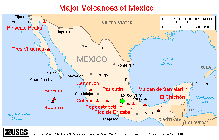
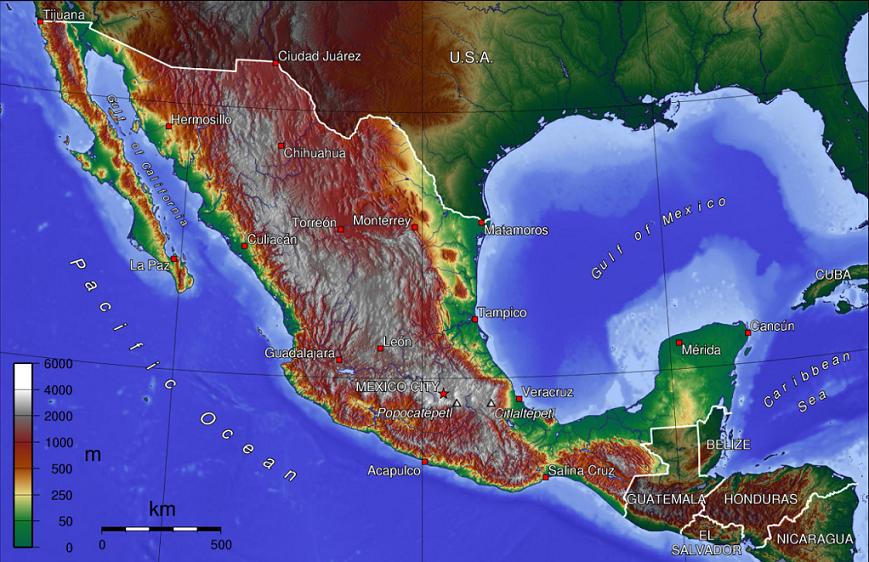
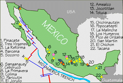
 | Mexico volcanoes norther of TMVB |
http://en.wikipedia.org/wiki/4000_meter_peaks_of_M%C3%A9xico#Highest_major_summits RES Master of Science In Geology See photos http://schubabala.wordpress.com/ http://www.volcanolive.com/mexico.html |
|
|
The compression forces, together with the subsiding plate produced a chain of volcanoes along the whole of the Sonora coast 30 MA.Some 30 million years ago, an old Mid Oceanic Ridge was getting close to the old Sonora coast, subsiding under Sonora. The compression forces, together with the subsiding plate produced a chain of volcanoes along the whole of the Sonora coast. |
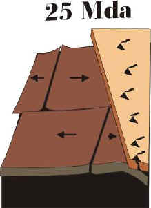
25 million years ago, the Oceanic ridge arrived at the edge of Sonora |
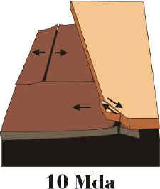
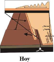
When it began subsiding under the Continent, the old compression strains transformed into the opposite, now of tension, forcing Sonora to "stretch" towards the West. This "stretching" of Sonora towards the coast formed the series of alternate ranges and valleys when the plates fractured, giving Sonora itґs current orography: ranges separated by valleys, all with a direction Northwest - Southwest. Besides this, a strip of land separated from the continental slab, and began traveling towards the Northwest. This originated both, the Gulf of California as well as the Peninsula. |
The birth of paralley mountain ranges and valleys |
Arizona |
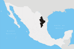
the Mexican state of Nuevo Leon |
El Potrero is a unique geological formation of limestone cliffs, some as high as 700 m. El Potrero Chico is an internationally renowned rock climbing area in the Mexican state of Nuevo Leon -http://en.wikipedia.org/wiki/Potrero_Chico |
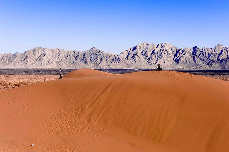
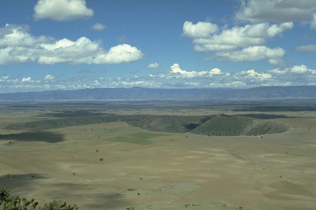
Volcano Pinacate, Sonora. 31.77 N, 113.49 W , summit elevation 1200 m, cinder cones. The volcanic area covers 60 km x 55 km in the Sonoran desert in NW Mexico. The volcano is in a sparsely populated region between Arizona and the Gulf of California. No recent eruptions. http://www.volcanolive.com/pinacate.html |
The Pinacate Peaks are a volcanic group of volcanic peaks and cinder cones located mostly in the Mexican state of Sonora along the international border adjacent to the U.S. state of Arizona, surrounded by the vast sand dune field of the Gran Desierto de Altar, at the desert''s southeast. The volcanoes here have erupted here sporadically since about 4 MA, probably in association with the opening of the Gulf of California. The most recent volcanic activity was about 11 KA. The Pinacate Desert is home to the largest sand dunes of the Americas. A variety of flora and fauna occur in the Pinacate Mountains, including the sculptural Elephant Tree, Bursera microphylla.http://en.wikipedia.org/wiki/Pinacate_Peaks |
Crater Elegante with the Pinacate Peaks in the background |
northern Sonora near Nogales |
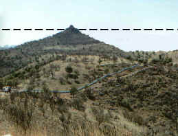
La Prinola is not a volcano, but a basaltic flow which covered all that region, later was eroded, and left a small layer of basaltic rocks in top of that hill. At the right we can see La Pirinola, with a dotted line indicating where the floor was located at the time of this basaltic flow, some 13 million years ago |
Within the municipality, this kind of rocks are known as Nogales Formation (dated from the second half of Miocene, between 5 and 15 mya), In particular, one outcrop of this kind of rock located near the border is known as "Cantera." |
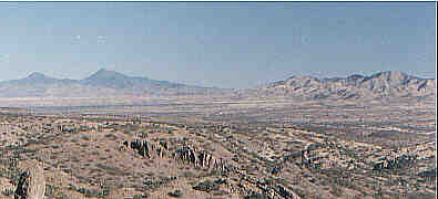
In the panoramic photo to our left, we can see the Santa Cruz Valley as seen from the heights of the Pinito Mountains. Left of the image are located the Santa Rita Mountains, and toward the right can be seen the San Antonio Mountains. The Santa Cruz Valley runs South to North (right to left in the image). |
Nogales, Sonora. In the Northeastern corner of the Municipality, in the San Antonio range, there is a small outcrop of rocks that have been dated from the Precambrian. They are Dioritic Intrusive Igneous rocks -http://www.municipiodenogales.org/English/geology/geology_municipality.htm# |
There are rocks from the Mesozoic that outcrop within the Municipality, with different origins, depending on how they were formed. They can be Marine deposits, originated during the Cretaceous, when our Municipality was submerged under the waters of a sea that came in from the East. The Nogales region was, in particular, the seashore of this sea.There are also Igneous rocks, corresponding either to the Laramide Orogeny, of the Nevada Orogeny, which are two time periods that have been named that way by geologists, during which our region was submitted to an intense vulcanism.In lesser degree, we also have metamorphic rocks, which formed under either sedimentary or igneous processes, and later were subjected to enormous compression and temperature, which changed them in part, but without melting them again.Within the city of Nogales, the rocks corresponding to this age are a granitic body (orange colored rocks, with grainy texture), extending along the southern part of the city.This outcrop covers Colonia Granja as well as part of the Cananea road, and is only interrupted by the Quaternary alluvion that forms the Arroyo Los Nogales |
Nogales, Sonora.In the map are shown the rock outcrops dating from the Tertiary.The Nogales Formation has been dated from around 13 MA, and corresponds to spillages of volcanic ashes mixed with other types of rocks.These rocks were deposited when, not only in today''s Nogales but all of the West Coast of Sonora was under a period of intense and explosive vulcanism.It was precisely then when the Sierra Madre Occidental was born as an enormous layer of rhyolitic lava flows which covered all of Central Mexico.-http://www.municipiodenogales.org/English/geology/geology_municipality.htm# |
These outcrops correspond mainly to lava flows (most of them rhyolites), as well as fluvial or lake deposits of volcanic ashes. These latest rocks are, for instance, the cliffs on Elias or Campillo streets, which geologically have been named the Nogales Formation |
Within the Municipality, the Quaternary rocks are almost all located along the valleys, as in the Arroyo Los nogales, Santa Cruz River, Alisos or Planchas de Plata.These are mainly alluvium and non consolidated conglomerates forming the valley floors.http://www.municipiodenogales.org/English/geology/geology_municipality.htm# |
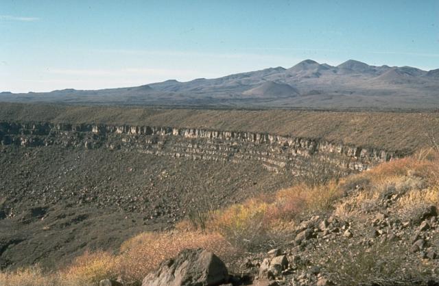
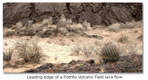
The Potrillo volcanic field is a monogenetic volcanic field located on the Rio Grande Rift, in a portion of its rift valley, in southern New Mexico, USA and northern Chihuahua, Mexico. The volcanic field lies 22 miles (35 km) southwest of Las Cruces, New Mexico - http://en.wikipedia.org/wiki/Potrillo_volcanic_field |
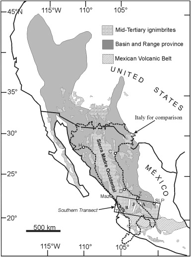
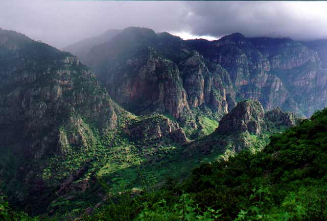
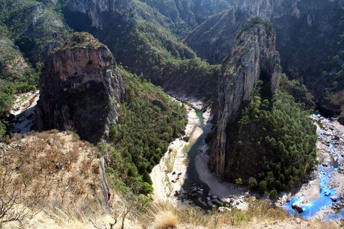
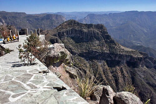
A sequence of volcanic rocks varying in age from 30 to 135 MA was slowly uplifted to an average elevation of 2275 m while being dissected by rivers. The Sierra Tarahumara is part of the Western Sierra Madre, an extensive volcanic tableland, affected by grabens (rift valley faulting) and faults which deprive it, especially on its flanks, of any homogeneous appearance. Its eastern side merges gradually into the Chihuahua basin and range landscape; its western side is much steeper, marked by major normal faults of considerable vertical extent, and by deep canyons. http://geo-mexico.com/?tag=geology |
The Sierra Tarahumara |
Tarahumara''s Frog''s Valley and the Mushroom''s Valley |
the Copper Canyon region. The Sierra Tarahumara is part of the Western Sierra Madre, an extensive volcanic tableland, affected by grabens (rift valley faulting) and faults which deprive it, especially on its flanks, of any homogeneous appearance. Its eastern side merges gradually into the Chihuahua basin and range landscape; its western side is much steeper, marked by major normal faults of considerable vertical extent, and by deep canyons. Stage 1The lower rocks.McDowell and Clabaugh (1979) describe two different igneous sequences, which were separated in time by a prolonged period of non activity. The older series is mainly comprised of intermediate igneous rocks between 100 and 45 MY; it shows evidence of lava flows and violent eruptive activity which produced andesitic pyroclasts. There are also layers of siliceous ignimbrites. This lower series includes many rich mineral deposits, though it outcrops in only restricted parts of the Canyon system. The volcanic activity in this area was associated with the subduction of the small (now destroyed) Farallon Plate which was pushed beneath the North American Plate by the expanding Pacific Plate. The line between the lower, older series and the higher, newer one is very irregular, indicating intensive erosional activity in the period between their times of formation.Stage 2. A break in activity allowing erosion to take place.The major lull in volcanic action, between 45 and 34 MA, may have been due to a change in the inclination of the subducting Farallon plate.Stage 3. The upper rocks.After this break in activity, there was a sudden resumption of vulcanism. The upper series is the most extensive cover of ignimbrite known anywhere in the world, covering an area which is 250 km wide, and 1200 km long from NW to SE. It stretches as far north as the southern USA. To the south, it disappears beneath the newer volcanic rocks of Mexico�s Volcanic Axis in Jalisco and Michoacбn. The ignimbrites are rhyolitic and rhyo dacitic in composition, generally approximately horizontal, or slightly tilted, and with ages between 34 and 27 million years. In places, these ignimbrites are more than 1000 m thick (Demant & Robin, 1965).It is unclear precisely where all these volcanic rocks originated. One estimate is that for such large volumes of rock to have been formed, there would have been between 200 and 400 volcanic outlets, some up to 40 km across. An alternative hypothesis (proposed by Aguirre-Dнaz & Labarthe-Hernбndez) is that large bodies of magma (molten rock underground) reached shallow parts of the crust and then partially erupted, explosively, along the fault lines of the existing basin and range structures. http://geo-mexico.com/?tag=geology |
Cupper canyon. Incised meanders near Umira, Chihuahua.The common rock types in the Copper Canyon region. Volcanic Ash is unconsolidated fragments <2 mm in diameter. Volcanic ash commonly contains larger (up to 64 mm) fragments called lapilli. Ash may be composed of crystalline rock (eg. rhyolitic and andesitic ashes), of glassy fragments (vitric ash), or of individual crystals (crystal ash). In general, the size of individual particles comprising the ash diminishes as distance increases from the volcano where it originated.Tuff is consolidated volcanic ash.Ignimbrites are essentially pieces of light, vesicular, pumice, in a matrix of glassy fragments. Ignimbrites are often layered and sometimes split into vertical columns. They are deposited from ash flows that included large volumes of hot, expanding gases and incandescent glass fragments.Lavas (molten rock on the surface). When lava cools and solidifies, it produces massive (as opposed to fragmentary) rocks, generally crystalline but of variable chemical composition (andesite, rhyolite, basalt).The major landforms of the Copper Canyon regionThese layers of igneous rocks were uplifted, forming a plateau with an average elevation of 2275 m (almost 7500 feet). Rivers have carved deep gashes, up to 1400 m deep, into the plateau surface, forming a series of steep-walled canyons, separated by giant blocks, remnants of the original, continuous plateau.. http://geo-mexico.com/?tag=geology |
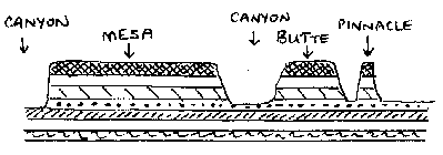
Since some of the rivers exhibit superb examples of incised meanders [see photo], some, possibly most, of these rivers already existed prior to the main periods of uplift. They were meandering across a gently sloping flood plain prior to the tectonic upheavals. Then, as the landscape slowly rose around them, they carved these giant canyons. These antecedent rivers retained their courses; the meanders were incised into the landscape.Centuries of erosion by the various rivers, including the Urique river and its tributaries, have resulted in the present-day landscape of structurally-guided plateau remnants, termed mesas, buttes and pinnacles (depending on their size). There are many examples of these distinctive landforms in the Copper Canyon region. |
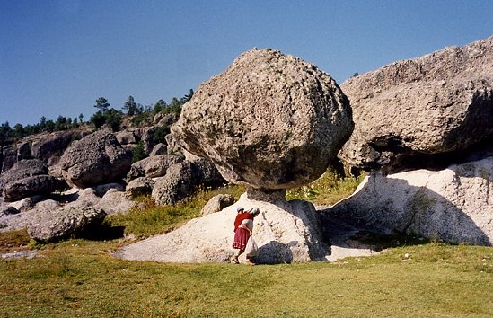
Perched block near San Ignacio. Photo: Tony Burton; all rights reserved.It is likely that some of the many waterfalls in the region were formed in places where the downward vertical erosion of rivers was insufficiently powerful to counteract the forces of uplift. Other waterfalls are more likely to have resulted from differences in the relative resistance of different rocks. The effects of differential erosion are noticeable in many smaller-scale features in this landscape, such as perched �mushroom� rocks.Examples of many of these landforms can be seen by anyone driving along the Creel-Batopilas road. At km 5 (from Creel) is the entrance to the Mission village of San Ignacio, near which are strange tor‑like rock formations, including �mushroom� rocks, where a more resistant capstone sits perched atop weaker rocks that are slowly being eroded away. At km 20 in Cus�rare, a short walk south of the road through woods and along the Cus�rare river leads to the very pretty 30-metre high Cus�rare waterfall. At km 44 (Basihuare), there are fine views of a mesa of pink and white rocks that overlooks the road. This is Cerro el Pastel (�Cake Mountain�) with its pinnacles. At km 56, near Umir� (or Humir�) are several spectacular incised meanders formed when the river�s course was preserved while the surrounding land was undergoing relatively rapid uplift. |
Cerro del Gallego lookout point |
Mun. de Ahumada, Sierra del Gallego, Rancho Coyamito |
Durango volcanic field. Durango volcano, summit elevation 2075 m, cinder cones. Durango volcano is located in northern central Mexico. Durango volcanic field consists of about 100 cinder and lava cones. The volcanic field has a sequence from hydromagmatic eruptions during formation of the maars, to strombolian eruptions, followed by post-maar lavas. This sequence reflects the declining influence of magma-groundwater interactions over time. Eruption - A few thousand years ago - http://www.volcanolive.com/durango.html |
Durango Volcanic Field: La Brena - El Jaguey Maar Complex -this is one of the youngest eruptive centers in the Durango Volcanic Field. It is a lava plain that covers 2100 sq km and includes about 100 cinder and lava cones. The volcanic complex consists of two intersecting maars - La Brena - El Jaguey, at least two pre-maar scoria cones and associated lavas.The sequence of eruptions at La Brena - El Jaguey complex includes; pre-maar scoria cones and lava flows, followed by hydromagmatic eruptions that formed El Jaguey Maar and then La Brena Maar, post-maar strombolian eruptions of La Brena, and most recently a complex series of lava and spatter eruptions on the floor of La Brena Maar. Pyroclastic-surge deposits from La Brena maar show both laminar and dune bedding forms. The thin beds (the pen in the center for scale) were created by successive explosive eruptions that produced high-velocity, laterally moving pyroclastic surges that swept radially away from the volcano. The direction of movement of the surge clouds was from right to left, as seen from the truncated dune beds on the near-vent side. Type/Process: Pyroclastic Flow. Volcanic Status: Holocene. Photographer: Jim Luhr, 1988 (Smithsonian Institution) Summit Elevation: 2075 m- http://www.mnh.si.edu/earth/text/dynamicearth/6_0_0_geogallery/geogallery_specimen.cfm?SpecimenID=261&categoryID=5&categoryName=Volcanoes&browseType=volcanoname&volcanoName=Durango%20Volcanic%20Field |
http://volcano.oregonstate.edu/vwdocs/volc_tour/mex/mex.html |
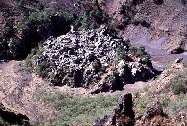
western Mexico Ceboruco Volcano -a small lava dome capped by blocky spines was extruded in the principal vent of the 1870-75 eruption of Ceboruco volcano in western Mexico. Fumaroles (not visible in this photo) with temperatures measured at about 100 degrees Centigrade are located around the base of the dome. The plug dome was extruded late in the eruption in a crater formed by explosions that decapitated the main vent of the 1870 eruption and significantly lowered the crater floor. PHOTO SOURCE: Lee Siebert 1997, courtesy of the Global Volcanism Program, Smithsonian National Museum of Natural History, used with permission.http://www.volcanodiscovery.com/sanganguey.html Volcan Ceboruco Ceboruco is a dacitic stratovolcano located in Nayarit, Mexico, northwest of the Trans-Mexican Volcanic Belt. http://en.wikipedia.org/wiki/Ceboruco_(volcano) |
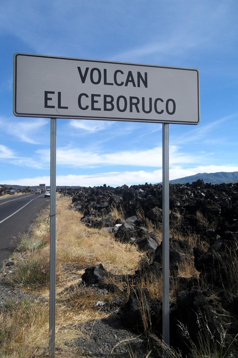
Ceboruco , elevation 2,280 m, is a dacitic stratovolcano located in Nayarit, Mexico, northwest of the Trans-Mexican Volcanic Belt, TMVB. The largest eruption, the Jala Plinian eruption, was around 930 AD +/-200, VEI 6, releasing 11 km3 of tephra. The most recent and best documented eruption from Ceboruco lasted from 1870�1875, with fumarole activity lasting well into the 20th century. The mountain features one large caldera, created during the Jala eruption, with a smaller crater nested inside that formed when the Dos Equis lava dome collapsed during the Coapales eruption around 1100 AD. Within both of these craters, are several explosive volcanic features, including scoria deposits, lava domes, and pyroclastic domes, or cinder cone volcanoes.Cooled lava flows preserved around the volcano keep a record of the recent eruptions. Before the Jala eruption, there is record of one major lava flow, called the Destiladero flow. During the 500 years after the Jala eruption, the volcano was at its most active, leaving record of six major lava flows: the Copales, El Cajon, Coapan I, Coapan II, El Norte, and Ceboruco flows, all before the Spanish arrived in 1521. The volcano remained active until the next major eruption in 1870, however volcanism was, for the most part, constrained within the calderas.Lava extruded from the volcano is primarily trachydacite to trachyandesite in composition, transitioning from more andesitic to more dacitic compositions over time. The magma is likely a mix from three different sources, a rhyodacite source, a dacite source (likely itself a mixture of rhyodacite and basalt), and a mafic source - http://en.wikipedia.org/wiki/Ceboruco_(volcano) |
Volcan Ceboruco -http://manxodoarte.blogspot.com/2012/06/volcanes-de-mexico.html Ceboruco last erupted from 1870 until 1872 to produce a large flank flow of andesite. According to RS Thorpe and PW Francis, in prehistoric times Ceborucco has had at least 2 very large eruptions that produced 2 concentric calderas. Ceborucco rises about 1000 m above its base and has a summit elevation of 2164 m. The original volcano was comprised mostly of thin andesite lava flows and pyroclastic layers. Since the calderas formed, however, the flows have tended to be thick, some are more than 100 m thick .Ceborico, 21.12 N, 104.50 W, summit elevation 2280 m, stratovolcano. It is is a major composite volcano at the western end of the Mexican Volcanic Belt, near the junction between the North American and Pacific plates. The volcano is built from successive eruptions of andesite lavas and pyroclastic rocks, and major eruptions have created two concentric calderas, and three central cinder cones. Cone construction has alternated with caldera formation. Ceboruco volcano rises 1100 m above a well-defined flat floor, of a linear NW-SE trending volcano-tectonic depression. It is part of a chain of volcanic centres, running northwest parallel to the fault trends. The eruption centres consist of small basaltic andesite scoria cones, lava flows, and a few extrusive domes of more viscous lava. Volcano building episodes at Ceboruco. 1) Construction of a simple conical volcano, composed of andesitic lavas and pyroclastic rocks. 2) Major caldera-forming eruption which produced the outer caldera. 3) Construction of a second simple cone, nested within the older caldera. 4) A second caldera-forming event produced an inner caldera, 1.3 kilometres in diameter.About 1000 years ago the volcano erupted Jala Pumice which was the largest eruption in Mexico in the past 10,000 years. The eruption produced a 4 km wide caldera. Eruptions 1567, 1542. An eruption of Ceboruco volcano began on 23rd February 1870-75. A 7.7 km long lava flow was extended from the crater along the Los Cuates Barranca over a two year period. From 20-28 March 1875 ash emissions reached 15 km altitude- http://www.volcanolive.com/ceboruco.html |
the Ceboruco |
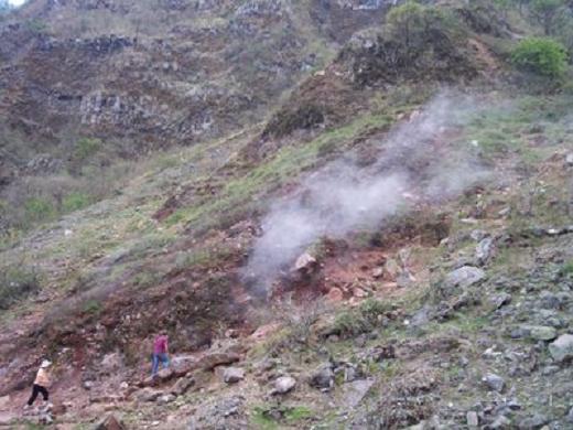
the crater of the Ceboruco, numerous fumaroles |
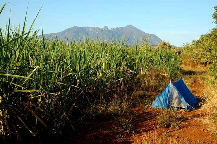
Sanganguey 21.45 N, 104.73 W, summit elevation 2353 m , stratovolcano . is located on the west coast of Mexico, 50 km from the Pacific Ocean. The volcano contains a lava spine at the summit.Sangangьey is a calc-alkaline volcano built on the southern flank of Las Navajas. Alkaline volcanism has occurred in the area with eruptions of alkali basalt from cinder cones located along NW-trending fractures. Fumarolic acticity reported in 2003.Possible eruption in 1742 - http://www.volcanolive.com/sanganguey.html |
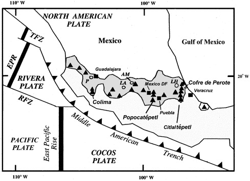
MVB, showing selected Quaternary volcanoes (triangles), silicic calderas (circles), and cities (squares), after Siebe et al. (1997). Calderas: P, La Primavera; LA, Los Azufres; AM, Amealco; LH, Los Humeros. TFZ, Tamayo fracture zone; EPR, East Pacific Rise; RFZ, Rivera fracture zone. Late-Pleistocene to precolumbian behind-the-arc mafic volcanism in the eastern Mexican Volcanic Belt. An area of widespread alkaline-to-subalkaline volcanism lies at the northern end of the Cofre de Perote�Citlaltepetl (Pico de Orizaba) volcanic chain in the eastern Mexican Volcanic Belt (MVB). Two principal areas were active. About a dozen latest-Pleistocene to precolumbian vents form the 11-km-wide, E�W-trending Cofre de Perote vent cluster (CPVC) at 2300�2800 m elevation on the flank of the largely Pleistocene Cofre de Perote shield volcano and produced an extensive lava field that covers >100 km2. More widely dispersed vents form the Naolinco volcanic field (NVF) in the Sierra de Chiconquiaco north of the city of Jalapa (Xalapa). Three generations of flows are delineated by cone and lava-flow morphology, degree of vegetation and cultivation, and radiocarbon dating. The flows lie in the behind-the-arc portion of the northeastern part of the MVB and show major- and trace-element chemical patterns transitional between intraplate and subduction zone environments. Flows of the oldest group originated from La Joya cinder cone (radiocarbon ages 42 000 yr BP) at the eastern end of the CPVC. This cone fed an olivine-basaltic flow field of ∼20 km2 that extends about 14 km southeast to underlie the heavily populated northern outskirts of Jalapa, the capital city of the state of Veracruz. The Central Cone Group (CCG), of intermediate age, consists of four morphologically youthful cinder cones and associated vents that were the source of a lava field>27 km2 of late-Pleistocene or Holocene age. The youngest group includes the westernmost flow, from Cerro Colorado, and a lava flow 2980 BP from the Rincón de Chapultepec scoria cone of the NVF. The latest eruption, from the compound El Volcancillo scoria cone, occurred about 870 radiocarbon years ago and produced two chemically and rheologically diverse lava flows that are among the youngest precolumbian flows in México and resemble paired aa�pahoehoe flows from Mauna Loa volcano. The El Volcancillo eruption initially produced the high effusion rate, short-duration Toxtlacuaya alkaline aa lava flow from the southeastern crater. This 12-km-long hawaiite (average 50.5% SiO2) flow was followed by extrusion of the calc-alkaline Rı́o Naolinco lava flow from the northwestern crater. This large-volume (1.3 km3) tube-fed basaltic pahoehoe flow (average SiO2 49%) traveled 50 km. Inferred effusion rates suggest emplacement over a decade-long period. Flows of all three age groups are transected by Highway 140 and the railway that form major transportation arteries between Jalapa and Puebla. This area has not previously been considered to be at volcanic risk, but volcanism here has continued into precolumbian time. Future eruptions of similar magnitude and location to those documented here could pose significant hazards to transportation corridors and to densely populated areas in and to the north of Jalapa. Slight variations in vent locations could produce future flows down one or more of more than a half dozen drainages with widely varying population densities. http://www.sciencedirect.com/science/article/pii/S037702730100316X |
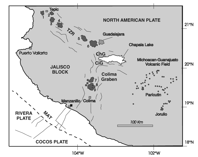
5�Tequila; 6�La Primavera caldera. Colima Volcanic field |
volcano; CE�Ceboruco volcano; TEQ�Tequila volcano; LP�La Primavera |
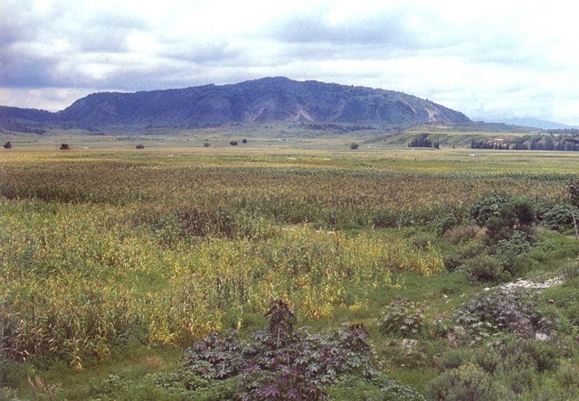
Cerro El Colli is a small rhyolitic lava dome that is one of the youngest post-caldera domes of the Sierra La Primavera volcanic complex, immediately west of the city of Guadalajara. The dome, seen here from the south, has been dated at about 30,000 years and is the easternmost of several emplaced along an arc near the southern caldera margin. An 11-km-wide caldera was formed as a result of the eruption of the 20 cu km Tala Tuff about 95,000 years ago. Steam vents and hot springs currently are active throughout the volcanic complex -http://www.volcano.si.edu/world/volcano.cfm?vnum=1401031E&volpage=photos&photo=100022 Photo by Hugo Delgado-Granados, (Universidad Nacional Autonoma de Mexico).Sierra la Primavera, summit elevation 2270 m, caldera is located in western Mexico, west of Guadalajara. Hot springs ans steam vents are present at the volcano.The Rio Caliente ignimbrite is a compound ignimbrite formed during a major late Quaternary explosive rhyolitic eruption of La Primavera volcano. The eruption sequence of the ignimbrite is complex and occurred between lower and upper plinian alr-fall deposits. Pumice flows were generated by the collapse of relatively low eruption columns.In some cases frothing at the vent may have occurred rather than column collapse, such as occurred at Mt St Helens. These columnless pumice flows which form ignirnbrites may be more common than are presently thought. Last eruption 30KA - http://www.volcanolive.com/primavera.html |
The spectacular giant pumice beds of Primavera volcano represent an unusual sedimentation event following formation of La Primavera caldera. Individual blocks of inflated pumice from 0.3 to >6 m across are enclosed within fine-grained lake sediments. The giant pumice blocks originated by eruption of rhyolitic lava into a caldera lake. The pumice fractured into large blocks that floated to the surface, rafted across the lake, and gently settled to the bottom. Subsequent deposition of fine-grained lake sediments buried the pumice blocks.Photo by Jim Luhr, 1979 (Smithsonian Institution). |
Fumaroles of the La Primavera geothermal field steam in the foreground along La Azufrera fault, whose trace can be seen in the vertical rock-filled gully in the background. Note the person observing the fault trace at the lower left-center for scale. The geothermal field at La Primavera has been explored by the Mexican Comision Federal de Electricidad (CFE). Exploratory drilling began in 1980.Photo by Pat Dobson, 1982 (Lawrence Berkeley National Laboratory).The Sierra La Primavera complex has been the site of extensive geothermal development. The drill rig here is at well PR-5, which was drilled to a depth of 1215 m. This well is located near the center of the caldera, just south of the Mesa El Nejahuete lava dome. Surface exposures in this location consist of tuffaceous lacustrine sediments and comenditic airfall tuffs.http://www.volcano.si.edu/world/volcano.cfm?vnum=1401031E&volpage=photos |
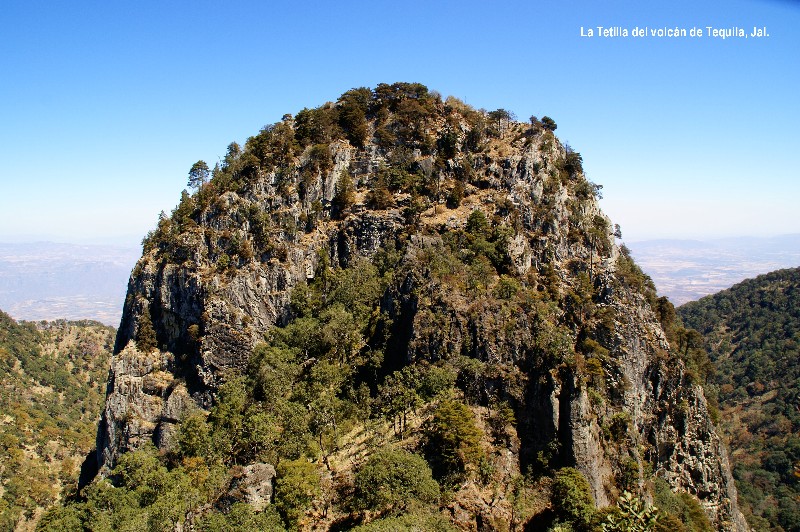
Tequila |
The Tequila Volcano is a volcano located near Tequila, Jalisco. The volcano rises to a height of 3,000 m, above sea level. This volcano is a stratovolcano or composite volcano. The Tequila Volcano last erupted 200 KA. That eruption covered the area in rich volcanic soil, making the area ideal for the growth of blue agave. |
Volcan deTequila.Tequila volcano is particularly unusual in that its crater has a well preserved central spine which, according to the geologically curious, most likely represents the material which solidified in the central vent of the volcano, as its activity subsided, and which was later pushed upwards by earth movements until it projected high above the floor of the crater. The classic example of a spine (and the one always quoted in geology texts) is that formed on Mount Pelee in the West Indies in 1902, which only lasted about six months before being broken down by weathering and erosion. The Tequila spine has already been around a lot longer than that, and looks well set to survive another few centuries at least. |
Puebla of Zaragoza |
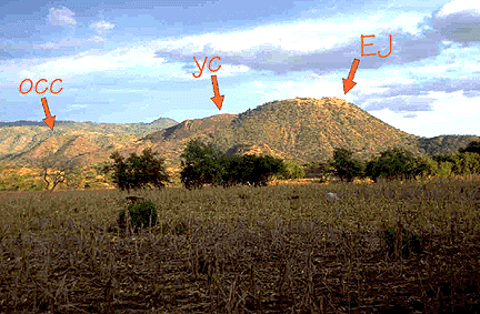
This photo shows another volcano that people watched being born. The largest cone (EJ) is El Jorullo, which first appeared in 1759. El Jorullo is covered by relatively fine ash, and has developed good plant cover since it stopped erupting (in 1774). YC is the youngest feature from the eruption, but it is covered with dense blobs of spatter that is apparently difficult for plants to sprout on. OCC is an old cinder cone from an unrelated eruption -http://volcano.oregonstate.edu/vwdocs/volc_tour/mex/11El_Jorullo.html |
Location of Nevado de Toluca volcano and other volcanic features in the tectonic frame of the central part of Mexico (after Johnson and Harrison, 1990). Quaternary volcanoes: 1=Ceboruco, 3=Colima, 4=Paricutı́n, 7=San Antonio, 8=Iztaccı́huatl, and 9=Popocatépetl. Calderas: 2=La Primavera, 5=Amealco, and 6=Mazahua Calderas: 2=La Primavera, 5=Amealco, and 6=Mazahua. Based on aerial photography, satellite imagery, and detailed field work, a geological and structural model of Nevado de Toluca and its surroundings is presented. The Nevado de Toluca volcano is built upon the intersection of three complex fault systems of different age, orientation, and kinematics. These systems from the older to the younger are: (a) The Taxco�Querétaro Fault System (NNW�SSE) with clear expression south of the volcano; (b) The San Antonio Fault System (NE�SW) that runs between the San Antonio and Nevado de Toluca volcanoes; and (c) The Tenango Fault System (E�W) located to the east of Nevado de Toluca volcano. Our field data, supported by previous studies, suggest that these systems have coexisted since the late Miocene. In addition, the stratigraphy, chronology, and kinematics of fault planes point to the existence of at least three main deformation events that have affected the region since the late Miocene. During the early Miocene, an extensional phase with the same deformation style as the Basin and Range tectonics of northern Mexico caused the formation of horsts and grabens south of Nevado de Toluca and allowed the intrusion of sub-vertical dikes oriented NW�SE and NNW�SSE. During the middle Miocene, a transcurrent episode generated NE�SW faults that presented two main motions: the first movement was left-lateral with a b3 oriented NW�SE and later turned into normal through a counter-clockwise rotation of b3 up to a N�S position. The latest deformation phase started during the late Pliocene and produced oblique extension (b3 oriented NE�SW) along E�W-trending faults that later changed to pure extension by shifting of b3 to a N�S orientation. These faults appear to control the late Pleistocene to Holocene monogenetic volcanism, the flank collapses of Nevado de Toluca volcano and the seismic activity of the region. http://www.sciencedirect.com/science/article/pii/S0040195199003169 |
Amealco is large rhyolitic caldera complex. Gerardo Sanchez-Rubio has determined that the caldera is 11 km wide and 400 m deep. With dimensions like this, combined with the fact that it is old and eroded, it is not a very obvious structure, and perhaps this is why it hasn''t been studied very much. It is truly impressive, however, when you consider the great sheets of pyroclastic flow deposits (called ignimbrites) that slope gently away from the caldera. These ignimbrites are in places more than 200 m thick, they cover at least 1600 square kilometers, and have a volume of about 500 cubic kilometers. Good thing Amealco erupted a long time ago- http://volcano.oregonstate.edu/vwdocs/volc_tour/mex/12Amealco.html |
(Volcanic evolution of the Amealco caldera, central Mexico http://www.geociencias.unam.mx/~ger/2000_GSASP_334_Ame.pdf) Collapse calderas are one of the most important volcanic structures not only because of their hazard implications, but also because of their high geothermal energy potential and their association with mineral deposits of economic interest. The objective of this work is to describe a new general worldwide Collapse Caldera DataBase (CCDB), in order to provide a useful and accessible tool for studying and understanding caldera collapse processes. The principal aim of the CCDB is to update the current field based knowledge on calderas, merging together the existing databases and complementing them with new examples found in the bibliography, and leaving it open for the incorporation of new data from future studies. This database does not include all the calderas of the world, but it tries to be representative enough to promote further studies and analyses. We have performed a comprehensive compilation of published field studies of collapse calderas including more than 200 references, and their information has been summarized in a database linked to a Geographical Information System (GIS) application. Thus, it is possible to visualize the selected calderas on a world map and to filter them according to different features recorded in the database (e.g. age, structure). The information recorded in the CCDB can be grouped in seven main information classes: caldera features, properties of the caldera-forming deposits, magmatic system, geodynamic setting, pre-caldera volcanism, caldera-forming eruption sequence and post-caldera activity. Additionally, we have added two extra classes. The first records the references consulted for each caldera. The second allows users to introduce comments on the caldera sample such as possible controversies concerning the caldera origin. A further purpose of this work is to construct the CCDB web page. In this web page where registered users can acquire the current database version, as well as to propose corrections or updates and to exchange information with other registered members also involved in the study of caldera collapse processes. Additionally, the CCDB includes a formulary that will facilitate the incorporation of new calderas into the database- http://www.sciencedirect.com/science/article/pii/S0377027308001182 |
The Mexican Volcanic Belt is a complex continental-margin volcanic province that crosses central Mexico from the Pacific coast to the Gulf of Mexico coast and forms part of the Pacific Ring of Fire. The book focuses on the calderas in the central portion of this belt, where calderas are more abundant and less well known than those in the eastern and western sectors of the province. Many caldera descriptions are published here for the first time. The calderas and related ignimbrites cover a wide span in time and space, with a Miocene-Pliocene age range. Very interesting magmatic and volcanic processes occur in each particular caldera and each caldera-ignimbrite description.The Mexican Volcanic Belt is a complex continental-margin volcanic province that crosses central Mexico from the Pacific coast to the Gulf of Mexico coast and forms part of the Pacific Ring of Fire. The book focuses on the calderas in the central portion of this belt, where calderas are more abundant and less well known than those in the eastern and western sectors of the province. Many caldera descriptions are published here for the first time. The calderas and related ignimbrites cover a wide span in time and space, with a Miocene-Pliocene age range. Very interesting magmatic and volcanic processes occur in each particular caldera and each caldera-ignimbrite description is unique. This book gives a description of these various processes and aligns them with what is known globally and provides geoscientists with a better understanding of the regional context of the calderas in the Mexican Volcanic Belt. Describes in detail the large range in textures and compositions of ignimbrites and includes new information about calderas in Mexico Provides a geologic map and stratigraphic type sections of the ignimbrites and associated calderas Summarizes over 20 years of research by the most recognized expert on calderas in Mexico�his expertise on the subject is well recognized internationally. Caldera types classification Chapter 3. The Mexican Volcanic Belt Chapter 4. Regional stratigraphy and tectonics of the central sector of the MVB Chapter 5. The Amazcala caldera Chapter 6. The Amealco caldera Chapter 7. The Los Agustinos caldera Chapter 8. The Apaseo caldera Chapter 9. The Donguinyу-Huichapan caldera complex Chapter 10. The Santa Marнa Macua caldera Chapter 11. The Los Azufres caldera Chapter 12. The La Muerta caldera Chapter 13. The San Pedro El Alto caldera Chapter 14. The Catedral caldera Chapter 15. Volcano-tectonic and geochemical implications. |
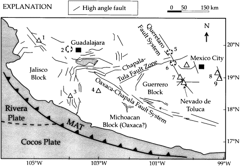
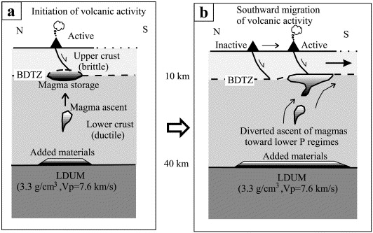
Southward migration of volcanic activity in the central Mexican Volcanic Belt: asymmetric extension within a two-layer crustal stretching model. Magmatic activity in the Miocene to present Mexican Volcanic Belt (MVB) is migrating to the south. Volcanic activity is associated with extension, which is being accommodated along a major, 1000-km-long, E�W-oriented continental rift. In turn, the MVB is cross-cut by older, though active N�S- to NNW-oriented major extensional faults, along which the polygenetic volcanoes are aligned. A southward migration pattern is also observed for the monogenetic volcanism, which however appears to be related to E�W- and N60�E-oriented extensional faults. We suggest that the southward migration of volcanic activity can be explained in terms of a two-layer crustal stretching model (brittle and ductile domains). The layers would be separated at an upper crustal level by a zone of simple-shear decoupling, at the brittle�ductile transition zone (BDTZ). The overall movement above the BDTZ is southward-directed, the only direction to which the Central MVB can extend and grow. Our model suggests that the magmas that feed the volcanism become stored at the BDTZ. Evidence supporting this assumption is provided by the Al-in-hornblende thermobarometer and the Ol�Pl�SiOr pseudoternary diagram, which indicate average pressures between 2.5 and 4 kbar. The magmas feeding the monogenetic volcanism ascend rapidly along active E�W and N60�E extensional faults (large strain rates), i.e. they do not have enough time to form large magma chambers. The magmas feeding the polygenetic volcanism are emplaced along N�S to NNW faults (lower strain rates). These magmas remain stored for longer periods at the BDTZ of the N�S to NNW faults, and therefore form large magmatic chambers, shaping vertical overshoots of several kilometers of height. The results from geobarometry indicating magma emplacement depth at around 8 km for the polygenetic volcanism, and 12 km for the monogenetic volcanism, are in good agreement with the rheological constraints of a BDTZ at about 10 km of depth. We envisage a feedback mechanism regarding magma storage and shallowing of the BDTZ, i.e. magma emplacement shallows the BDTZ; in turn, this shallowing controls the new zones for magma emplacement, a southward directed process - http://www.sciencedirect.com/science/article/pii/S0377027301002402 |
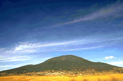
This is Jocotitlan, a small strato volcano northeast of Mexico City. At the summit are a bunch of radio and TV relay stations, and around the base are lots of small towns. Most of the flanks are covered with pine forests. It is a beautiful place, fifty four km north of Toluca. This area is in the northwest of the state, in the Ixtlahuaca Valley, which is formed by small mountain chains that belong to the Sierra Madre Occidental, with some formations as a result of being on the Trans-Mexican Volcanic Belt. Elevation varies from 2,530 m asl next to the Lerma River on the far south to 2,900, on one side of the Jocotitlan volcano, with an average of 2,770. However, much of the land in the area is relatively flat and covers much of the Ixtlahuaca Valley. Other elevations include hills in San Miguel Tenochtitlбn, and Santiago Casandeje.The Jocotitlan volcano or Xocotepetl is an isolated volcano and is the tallest peak in the immediate area. It is inactive with an altitude of 3,928 m above sea level at its peak, rising 1,300 m above valley floor. The volcano developed during the Pleistocene of andesitic-to-dacitic lava flows. The most prominent feature of the volcano is a horseshoe-shaped escarpment open to the northeast that formed as a result of gravitational failure of the summit during the early Holocene. The resulting debris-avalanche deposit covers an eighty km2 area to the northeast, although much of soils all around contain volcanic residues. The last known eruption occurred about 700 years ago, but there is still a possibility of it reactivating and should be monitored. The volcano is part of an ecological reserve as part of the Isidro Fabela State Park . Wildlife includes rabbits, coyotes, bobcats, skunks, opossum, armadillos, squirrels, bats and foxes. Bodies of water often contains carp . |
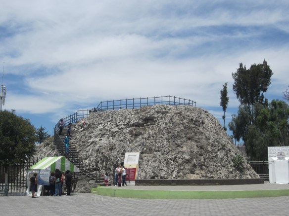
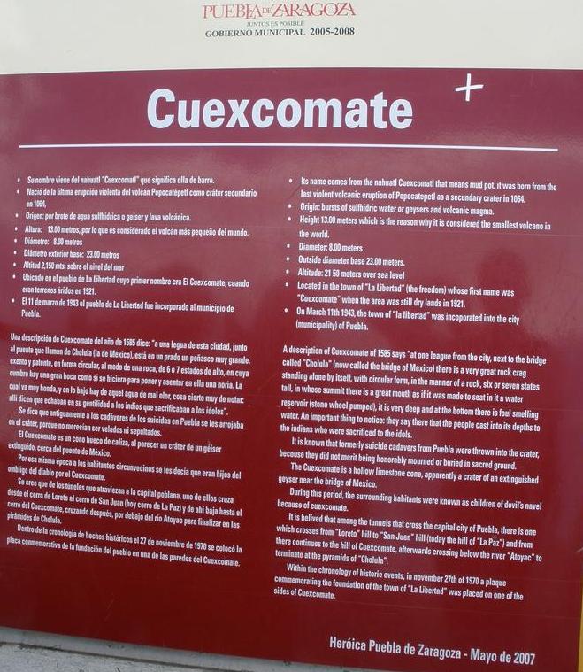
Small volcano in city Pueblo. Cuexcomate is an inactive volcano in Puebla city. Actually, the Cuexcomate is not a real volcano because it formed as a geyser.It stands at 13 m with a diameter of 23 m and is thought to be the smallest volcano on Earth. The volcano was formed in 1064 by an eruption of the Popocatepetl. A description of the Cuexcomate Volcano from the year 1585 says: "at one league from this city, close to the bridge that they call Cholula, there is in a large grassland... in circular shape, a rock of 6 or 7 estados high, at the top of which there is a great mouth as if it were made to hold a waterwheel. The which is very deep, and at the bottom of which there is foul smelling water, a very important thing to note: there they say that in the heathen days they threw in (indios) natives to be sacrificed to their idols."The crater of Cuexcomate is an empty sinter cone of an extinct geyser. It was formed by a burst of hydrogen sulfide geyser, and volcanic lava, as a chain reaction from the 1064 eruption of Popocatepetl.It was said that in ancient times, the people of Puebla threw the bodies of suicide victims into the crater, because they didn''t deserve to be mourned or buried.During this same time, the people living around the volcano were said to be ''children of the devil'' or ''under the rule of the devil'', because of Cuexcomate. It is believed that of the various tunnels that cross under the city of Puebla, Puebla, one travels from the hill of Loreto to the hill of San Juan(now the hill of La Paz) and from there travels down to the hill Cuexcomate, afterward crossing under the Atoyac river and ending in the Archaeological zone of Cholula and its pyramids.http://en.wikipedia.org/wiki/Cuexcomate |
Cuexcomate |
|
Crater Elegante with the Pinacate Peaks in the background |
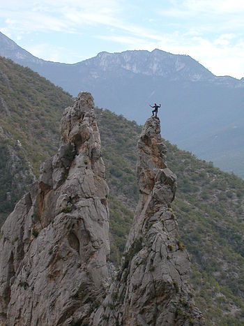


El Portero Chico - Potrero Chico�s limestone walls
Author: Alberto Suarez Barnett Source: http://www.municipiodenogales.org http://www.municipiodenogales.org/English/geology/geology_municipality.htm
Ambos Nogales Geology
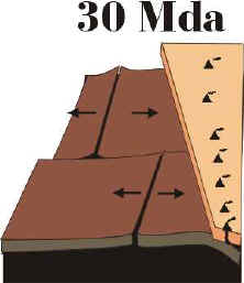
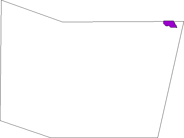
During the Mesozoic Era, the Western coast of Sonora was experimenting the subduction of an oceanic plate, equivalent to the diagram shown at right.
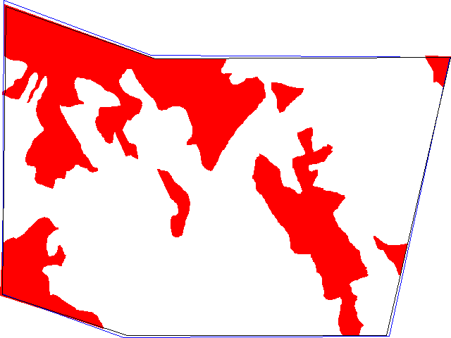
This subduction gave birth, between 215 to 180 MA (from the late Triassic to the Jurassic) to a line of volcanoes which followed an orientation North - South in our region. These volcanoes produced rhyolitic to dacitic lava spills, as well as numerous granitic and monzonite intrusives (that is, lava bodies which didn''t erupt and cooled underground). Outcrops from this time period can be seen in the interactive map which appears further down in this text.
In Nogales, Sonora, all along the Colonia Granja as well as towards the Cananea road, we have a granite outcrop (an orange colored rock, formed by grains of different tonalities), which correspond to this age, 150 mya (red delimited areas in the map)
North of Nogales, Arizona, Benedict Mtn was also formed by an intrusive (melted rock which didnґt come out to the surface as lava) corresponding to this age which, obviously, is the result of a magma body which didnґt came to the surface (green delimited areas in the map).
Jurassic to Cretaceous
Later, during the last stages of the Jurassic and beginning of Cretaceous, that is some 144 ma, vulcanism diminished, and our region turned into a zone of nonmarine deposits.
Later, there would be a short time period when the sea invaded from the East to Sonora, turning the region around Nogales into the seashore of this marine basin. This shallow sea covered todayґs States of Coahuila, Chihuahua and Eastern Sonora. From this time period are dated the marine fossils that can be found both, North of Nogales near Patagonia, Arizona, as well as South, east of Magdalena, near Cucurpe, in Sonora.
Cenozoic
Tertiary
Later, after the sea retreated towards the East, between 90 and 80 ma (late Cretaceous), it was succeeded by another Oceanic - Continental collision which again brought vulcanism with it. This vulcanism continued until some 52 ma, that is during the Tertiary. This volcanic activity is named Laramide Orogeny, and itґs process is very important economically, as it originated the mineral deposits, like Copper, which Northern Sonora and Southern Arizona have. This vulcanism was mainly andesitic (rocks of an intermediate color which came to the surface in explosive eruptions).
During this time period of intense volcanic activity, the first phase would give birth to the Sierra Madre Occdental, which is a layer of andesitic flows with a thickness of about one kilometer, forming a great plateau in central Mexico, and which extends North to cover also Chihuahua.
It would be followed by a period of geologic inactivity, until some 35 ma, when vulcanism reappeared. This last stage is named the Mid Tertiary Orogeny. It was divided in two phases: the first one, when rhyolitic rocks were expelled as lava (light rocks, which came out in an explosive form); followed by another kind of vulcanism, of basaltic rocks (black colored, which flow in a nonexplosive manner).
From the first stage, we have the hills located both East and West of downtown Nogales; and from the second stage, corresponding to basaltic vulcanism, we have in Nogales flows located both East as well as Southeast of the city: near Panteon de los Heroes, near Las Cuevitas (these rocks have been dated at 13 ma), near the water pumping station located towards Mascareсas, and La Pirinola hill.
By the way, La Prinola is not a volcano, but a basaltic flow which covered all that region, later was eroded, and left a small layer of basaltic rocks in top of that hill. At the right we can see La Pirinola, with a dotted line indicating where the floor was located at the time of this basaltic flow, some 13 MA.
As one gets close to La Pirinola, the layer of basaltic rocks will become apparent. From this time, there are still a few remaining basaltic volcanic craters that can be seen near La Arizona, as well as nearby the remains of basaltic flows will become visible.
The highest spot in the Municipality is the summit of Sierra Guacomea, located in the central southern limit, at 31� 02'' 33" / 110� 58'' 41" and 2,089 m above sea level (meters), while the lowest is at the Sothwest corner, in the Arroyo Planchas de Plata, near El Potrerito, with 900 m.
Within the city of Nogales, Sonora, the lowest point is located at the De Concini border crossing gate, with 1, 177 m. From there, the ground is raised gradually as one travels South, following the Arroyo Los Nogales. The 1,200 m height is located a little North of Basurto Street, on Obregon Street; the 1,250 m are located at the PINSA Industrial Park, while the Lomas or Encinas bridge, where the railroad crosses under the highway, is located at 1,320 m.
The average slope of the Los Nogales creek is 1%, while it''s main affluent, La Granja, has an average slope near 1.6% Along it, the point where it intersects Arroyo Los Nogales is at 1,205 m, the Sports Complex at 1,230 m, and the dam of the Granja, at 1,280 m.
The Cerros Altos, located near the dam, are the highest point near Nogales, with 1,640 m.
Within the city, some inhabited spots have a height of 1,350 m, at Las Torres, Nuevo Nogales, San Carlos and near Pueblo Nuevo.
Nogales, Arizona, heights:
In Nogales, Arizona, as in Nogales, Sonora, the general slope goes toward the North. The overpass where the Patagonia road begins, is at 1,300 m while a little North of the confluence of Main and Mariposa, the height reached is 1,250 m.
This basaltic vulcanism was originated at the time of the end of the compression forces which had been exerted towards Western Sonora (when the the whole oceanic plate which had been colliding against it was subducted), and was replaced by a new set of tension forces, which stretched Sonora East-West, and also gave birth to the California Gulf.
This new process of stretching of Sonora gave birth to two new processes:
In Northern Sonora, todayґs relief was born, which is formed by a set of parallel valley and mountain ranges, as is shown in the Municipality Topography webpage. As can be seen in it, the ranges in the Municipality, the same as in the rest of Sonora, also follow a Northeast-Southwest direction, and are separated by valleys. These ranges are bounded by normal faults, which also limit the intermediate valleys.
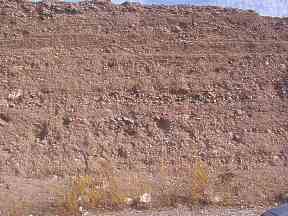
At the time of the formation of these mountain and valleys, the fallen blocks were transformed into closed watersheds, which gradually began to be filled by sediments from the nearby mountains. These sediments hardened gradually, until they formed a conglomerate
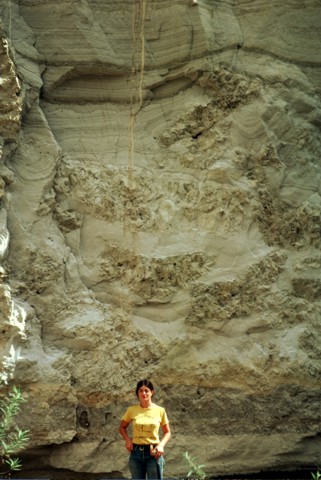
It has been calculated that the sedimentation rate of this rock was of about 200 meters every million years. At the right can be seen an outcrop of this kind of rock, located in Southern Nogales, Sonora, along the top of Colonia San Carlos.
Within the municipality, this kind of rocks are known as Nogales Formation (dated from the second half of Miocene, between 5 and 15 ma), In particular, one outcrop of this kind of rock located near the border is known as "Cantera."
After these closed watershed became filled up with sediments, they began to communicate and drain towards the sea. This was the process that gave birth to the Santa Cruz River as well as its tributaries, one of them being the Arroyo de Los Nogales.
In the panoramic photo to our left, we can see the Santa Cruz Valley as seen from the heights of the Pinito Mountains. Left of the image are located the Santa Rita Mountains, and toward the right can be seen the San Antonio Mountains. The Santa Cruz Valley runs South to North (right to left in the image).
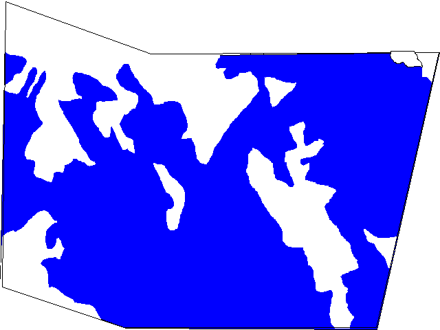
Outcrops within the Municipality
As has been shown in the previous text, in the Municipality can be seen outcrops of rocks from the following time periods.
There are rocks from the Mesozoic that outcrop within the Municipality, with different origins, depending on how they were formed.
They can be Marine deposits, originated during the Cretaceous, when our Municipality was submerged under the waters of a sea that came in from the East. The Nogales region was, in particular, the seashore of this sea.
http://gsabulletin.gsapubs.org/content/93/4/303.abstract -Tertiary volcanic history of the Sierra del Gallego area, Chihuahua, Mexico (PETER C. KELLER, NEIL T. BOCKOVEN and FRED W. McDOWELL)
Mapping of 3,400 km2 in the Sierra del Gallego area, 110 km north of Ciudad Chihuahua, Mexico, has revealed about 1,000 m of volcanic rocks unconformably overlying Lower Cretaceous limestone of the Chihuahua Tectonic Belt. The regional structure is dominated by Basin and Range faults that trend north-northwest and cut all volcanic units.
Whole-rock and feldspar K-Ar age determinations, combined with whole-rock chemical analyses, show that subalkalic volcanism took place 45 to 29 m.y. ago, except for a conspicuous hiatus between 36 and 29.5 m.y. Between 45 and 39 m.y. ago, the area was covered by thin widespread blankets of rhyolitic ash-flow tuff derived from distant sources. These ash flows appear to correlate with units associated with a major uranium deposit about 50 km to the south, in the Sierra Peña Blanca. At Sierra del Gallego, these ash flows were followed by a 300-m thickness of extensive andesitic lava flows formed by magma mixing, and about 38 m.y. ago by a rhyolitic lava flow unit approximately 150 m thick. Around 36 m.y. ago, numerous local rhyolite flows and domes were emplaced. Approximately 29 m.y. ago, a renewed surge of volcanic activity produced a widespread 125-m thick group of basalt flows accompanied by a thin rhyolitic ash flow.
Volcanism at Sierra del Gallego is broadly contemporaneous with and is gradational in composition between voluminous calc-alkalic activity in the Sierra Madre Occidental to the west and alkalic volcanism to the east in Trans-Pecos Texas. Tertiary rhyolitic volcanism throughout this region was controlled by tectonic patterns that preceded the profound episode of crustal extension so obvious in the present regional topography.
http://en.wikipedia.org/wiki/List_of_volcanoes_in_Mexico
http://en.wikipedia.org/wiki/Category:Volcanism_of_Mexico
http://en.wikipedia.org/wiki/Volcanoes_of_east-central_Baja_California
http://en.wikipedia.org/wiki/List_of_volcanoes_in_Mexico
http://en.wikipedia.org/wiki/Category:Volcanism_of_Mexico
http://en.wikipedia.org/wiki/Baja_California_peninsula
http://www.csus.edu/indiv/h/hausback/PDFs%20of%20Publications/Hausback%201984%20Cenozoic%20Volcanic%20and%20Tectonic%20Evolution%20-%20Baja.pdf - Cenozioc Volcanos and tectonic evolution of Baja california sur, Mexico
http://www.volcanodiscovery.com/baja-california.html
http://www.volcanolive.com/mexico.html
http://www.volcanodiscovery.com/baja-california.html
The following movie shows all of this process, reconstructing the last 36 million years: The separation and emigration of the Lower California Peninsula, the birth of the Gulf of California, and the "stretching" of Sonora in a direction East - West
Region of Nogales
Mexican volcanoes, framework
Mexican geology
Mexican volcanoes