 | Volcanoes in Mexico |
http://www.eoearth.org/article/Mexico |
|
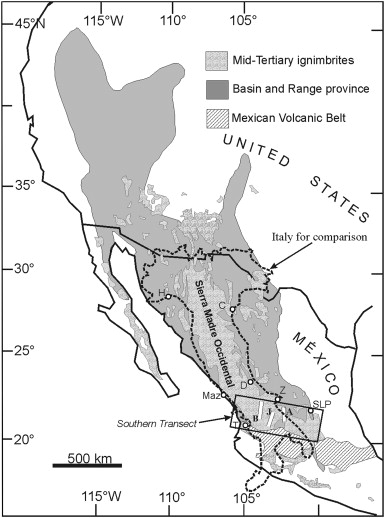
Index map of the Sierra Madre Occidental (SMO) volcanic province with area of graben calderas, the Basin and Range extensional tectonic province, and of Mid-Teriary ignimbrites in Mexico and the SW United States. from Geological Society of America). http://www.sciencedirect.com/science/article/pii/S1871644X07000046 |
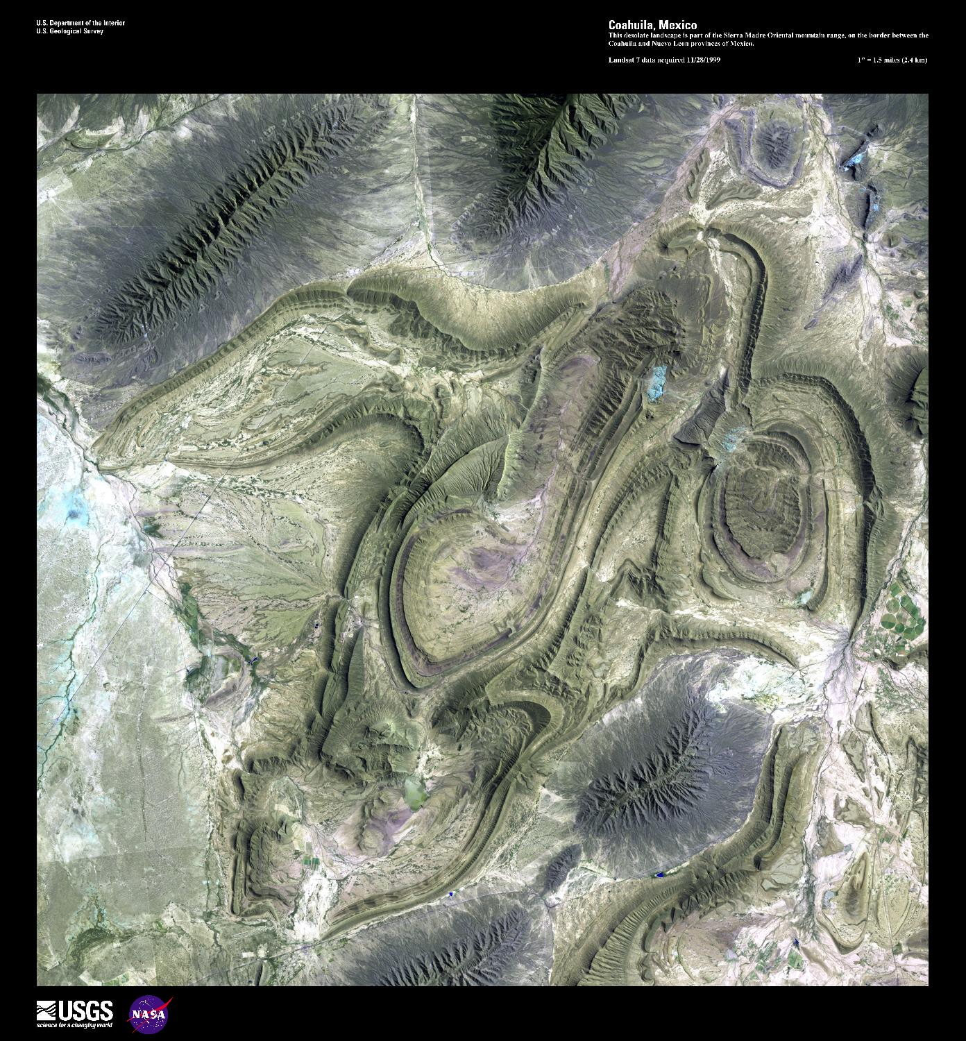
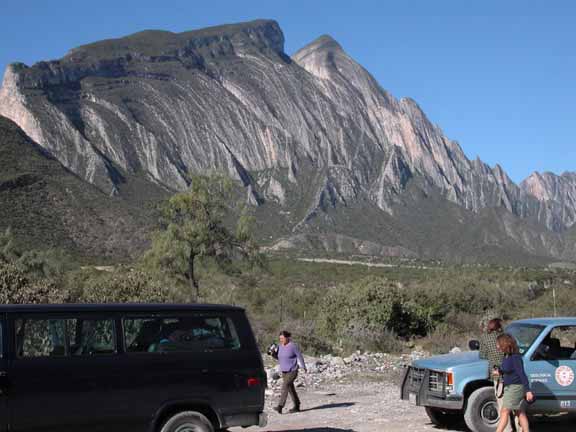
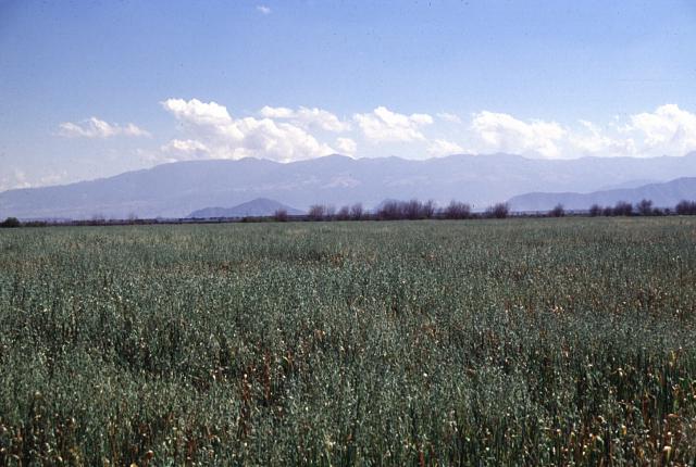
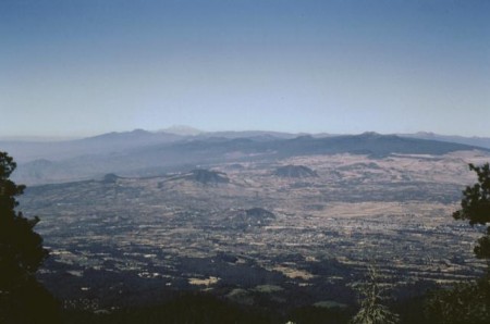
This high-resolution satellite image shows part of the Sierra Madre Oriental mountain range, on the border between the Coahuila and Nuevo Leon provinces of eastern Mexico. This range is part of the Sierra Madre Mountains that divide Mexico, and which also include the Sierra Madre Occidental on the West coast and the Sierra Madre del Sur in southern Mexico. In the area shown, ancient sedimentary rocks were folded as a result of a tectonic collision that some geologists consider related to the Appalachian folding of eastern North America. This mountain range is drier than the rainforest areas to the south. Image courtesy of USGS -http://www.eoearth.org/article/Mexico |
Monterrey |
Marbella |
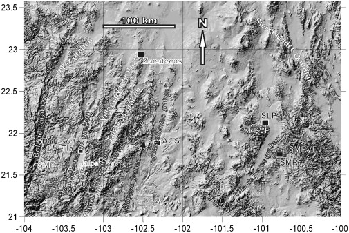
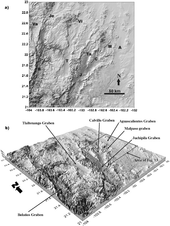
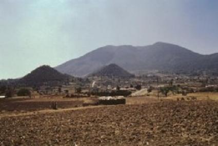
Graben calderas of Sierra Madre Digital shaded elevation model of the southern sector of the SMO showing the location and extent of several graben in this sector, and of the San Luis Potosi Volcanic Field (SLPVF) and the Santa Marнa del Rнo Volcanic Field (SMRVF). Towns shown: Bol, Bolanos; SMB, San Martнn de Bolaсos; Tla, Tlaltenango; Ju, Juchipila; AGS, Aguascalientes; SLP, San Luis Potosi; SMR, Santa Maria del Rio http://www.sciencedirect.com/science/article/pii/S1871644X07000046 |
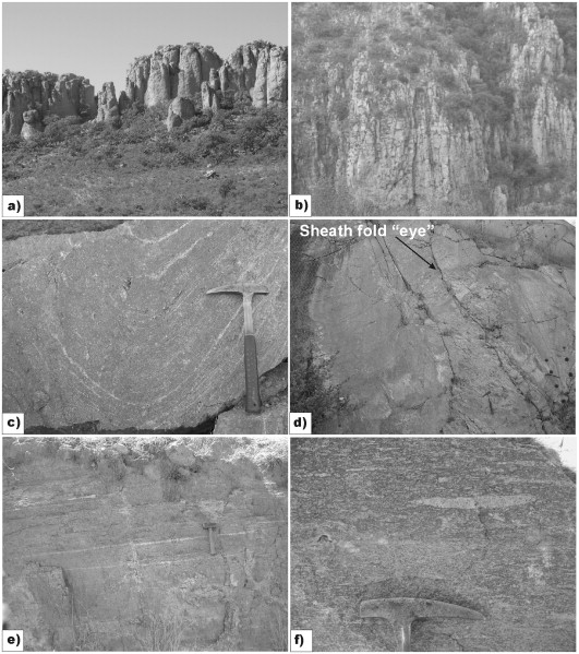
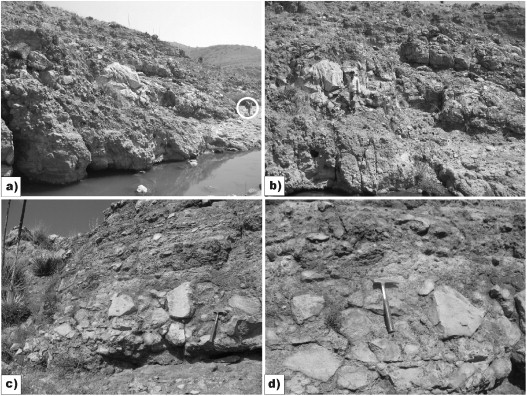
El Ocote ignimbrite at several localities. (a) Out-flow, near-vent facies of El Ocote ignimbrite at the Sierra El Laurel, close to the type locality. The ignimbrite is high-grade and forms well-developed columnar joints. Thickness at this site is 70¢120 m. (b) Intra-graben caldera ignimbrite fill of El Ocote ignimbrite, near the fault scarp of Sierra El Laurel. The ignimbrite is about 400 m thick with no base exposed, and includes co-ignimbrite lithic-lag breccias (not visible in photograph). (c) Lava-like, rheomorphic fold in extremely high-grade El Ocote ignimbrite at intra-graben caldera outcrop. (d) Sheath fold (eye-structure) in lava-like, extremely rheomorpic high-grade facies of El Ocote ignimbrite in intra-graben caldera outcrop. (e) Flat-lying, lava-like, high-grade El Ocote ignimbrite at near-vent out-flow facies close to El Ocote. (f) Flat-lying, high-grade El Ocote ignimbrite at the northern out-flow facies that formed the Mesa San Jose de Gracia. Pumice is collapsed but not as extremely elongated as in near-vent facies http://www.sciencedirect.com/science/article/pii/S1871644X07000046 |
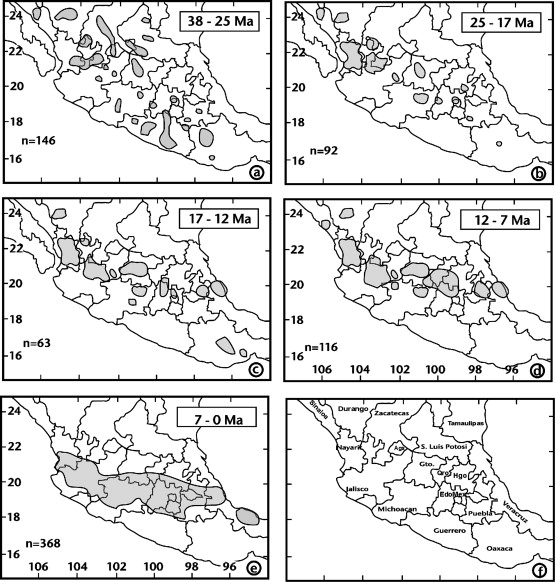
Space¢time patterns of volcanism in Mexico, from 38 Ma to Present representing the distribution patterns of continental margin volcanism from the SMO to the Mexican Volcanic Belt. Patterned areas represent volcanic rocks distribution for the indicated time period. States of central and southern Mexico are also shown for reference, where: Ags, Aguascalientes; Gto, Guanajuato; Qro, Queretaro; Hgo, Hidalgo; EdoMex, Estado de Mexico. Modified from Ferrari et al. (1999). |
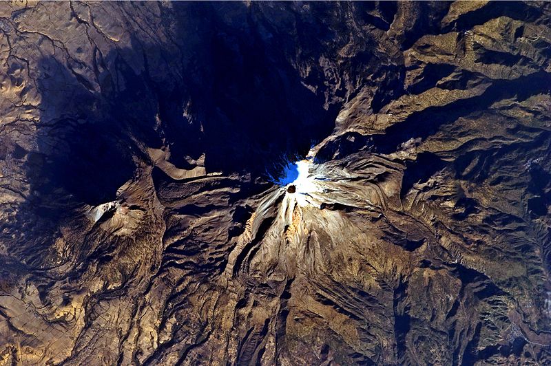
Digital elevation models of the grabens at the SW sector of the SMO. (a) Plan view; the graben are: Va, Valparaiso; Je, Jerez; Vi, Villanueva; B, Bolanos; T, Tlaltenango; J, Juchipila; Ta, Tabasco; C, Calvillo; M, Malpaso; A, Aguascalientes. (b) The deepest graben is Bolanos in the segment between 21.2░ and 22░ Lat. N. This deep segment corresponds to the graben caldera of Bolanos http://www.sciencedirect.com/science/article/pii/S1871644X07000046 |
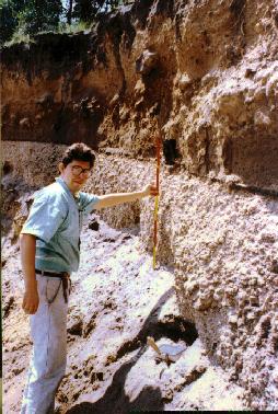
Co-ignimbrite lithic-lag breccias associated with Panalillo Inferior ignimbrite in the Juachin Fault System. (a) Coarse lithic-lag breccias at the vent site, along a major normal fault next to El Juachнn creek. The lithics are mostly of rhyolitic and dacitic lavas of older units in a pumiceous ash matrix. Note person for scale (in circle). (b) Lithics within breccias at (a) can be up to 3 m in diameter, this particular one shown in photograph next to geologist is 2.5 m across. (c) Angular clasts in the near-vent facies of the lithic-lag breccias at the vent facies. The deposit is a layered sequence of several co-ignimbrite lithic-lag breccia units indicating that it was formed from several eruptive pulses. (d) Detail of lithic-lag breccias supported by pumice-ash matrix. http://www.sciencedirect.com/science/article/pii/S1871644X07000046 |
the Eastern Mexican Volcanic Belt - http://www.sciencedirect.com/science/article/pii/S0377027306003106 |
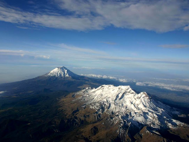
Trans-Mexican Volcanic Belt: LR Ixtaccihuatl, Popocatepetl, Matlalcueitl (Malinche), Cofre de Perote (most distant), Pico de Orizaba, Sierra Negra -http://en.wikipedia.org/wiki/Trans-Mexican_Volcanic_Belt The Trans-Mexican Volcanic Belt is a volcanic belt that extends 900 km from west to east across central-southern Mexico. Several of its highest peaks have snow all year long, and during clear weather, they are visible to a large proportion of those who live on the many high plateaus from which these volcanoes rise. The Mexican Plateau lies to the north, bounded by the Sierra Madre Occidental to the west and Sierra Madre Oriental to the east. The Cofre de Perote and Pico de Orizaba volcanoes, in Puebla and Veracruz, mark the meeting of the Trans-Mexican Volcanic Belt with the Sierra Madre Oriental. To the south, the basin of the Balsas River lies between the Trans-Mexican Volcanic Belt and the Sierra Madre del Sur. This area is also a distinct physiographic province of the larger Sierra Madre System physiographic division.The highest point, also the highest point in Mexico, is Pico de Orizaba (5,636 m).This, and several of the other high peaks, are active or dormant volcanoes; other notable volcanoes in the range include (from west to east) Nevado de Colima (4,339 m), Paricutin (2,774 m), Nevado de Toluca (4,577 m), Popocatepetl (5,452 m), Iztaccihuatl (5,286 m), Matlalcueitl (4,461 m) Cofre de Perote (4,282 m) and Sierra Negra, a companion of the Pico de Orizaba (4,580 m).The mountains are home to the Trans-Mexican Volcanic Belt pine-oak forests, one of the Mesoamerican pine-oak forests ecoregions.The Trans-Mexican Volcanic Belt has many endemic species including the Transvolcanic Jay (Aphelocoma ultramarina).Topographic elevation is the vertical distance above the reference geoid, a precise mathematical model of the Earth''s sea level as an equipotential gravitational surface. Topographic prominence is the elevation difference between the summit and the highest or key col to a higher summit. Topographic isolation is the minimum great circle distance to a point of higher elevation.This article defines a significant summit as a summit with at least 100 m of topographic prominence, and a major summit as a summit with at least 500 m of topographic prominence. An ultra-prominent summit is a summit with at least 1500 m of topographic prominence. There are 27 ultra-prominent summits in Mexico. |
Sierra Negra |
Sierra Negra and Pico de Orizaba. Sierra Negra is an extinct volcanic companion peak of Mexico''s highest mountain, the Pico de Orizaba (Citlaltepetl). At up to 4,640 m above sea level it is one of Mexico''s highest peaks, perhaps even the fourth highest, though it is usually listed fifth. However, because it is overshadowed by its much higher companion it is not as well known as, for instance, the slightly lower Matlalcueitl (Malinche), and is often not included in lists of Mexico''s mountains http://en.wikipedia.org/wiki/Sierra_Negra |
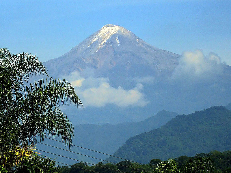
The Pico de Orizaba , Cordillera Neovolcanica,5700m, eruption 1687 is a stratovolcano, the highest mountain in Mexico and the third highest in North America. It rises 5,636 m above sea level in the eastern end of the Trans-Mexican Volcanic Belt, on the border between the states of Veracruz and Puebla. The volcano is currently dormant but not extinct with the last eruption taking place during the 19th century. It is the second most prominent volcanic peak in the world after Africa''s Mount Kilimanjaro http://en.wikipedia.org/wiki/Volc%C3%A1n_Citlalt%C3%A9petl |
Pico de Orizaba evolved in three stages, the most recent initiating about 16,000 years ago during the late Pleistocene and Holocene. Citlaltйpetl consists of three superimposed stratovolcanoes and dome intrusions which are: Torrecillas (650¢250 ka), Espolon de Oro (210¢ 16 ka), and Citlaltepetl (16 ka to present). The volcano was formed by thick andesitic and dacitic lavas that followed repetitive explosive eruptions and lava effusions which created the iconic cone structure. The volcano is currently dormant but not extinct. The latest eruption of the volcano occurred in 1846 with a magnitude of VEI 2. Previous eruptions occurred in: 1687, 1613, 1589¢1569, 1566, 1555¢1545,1539¢1533, 1351, 1260, 1187, 1175, 1157, 220 AD, 140 AD, 90 AD, 40 AD, 780 BC, 1500 BC, 2110 BC, 2300, 2500, 2780, 4690, 6220, 6710, 7030, and 7530. The most violent eruption in the volcano''s history is thought to have occurred around 6710 BC reaching a magnitude of VEI 5 characterized by lava dome extrusion and pyroclastic flow. http://en.wikipedia.org/wiki/Volc%C3%A1n_Citlalt%C3%A9petl |
Volcan Citlaltepetl (Pico de Orizaba), a stratovolcano on the boundary between the states of Puebla and Veracruz, is the highest mountain peak of Mexico. http://en.wikipedia.org/wiki/4000_meter_peaks_of_Mexico#Highest_major_summits The volcano is located on an important normal fault zone that marks out the Altiplano from the Mexico Gulf coastal plains.The volcano is located at the southern end of Citlaltepetl¢Cofre de Perote Volcanic Range, and is the only historically active volcano in the area. The edifice of Citlaltepetl volcano consists of three superimposed stratovolcanoes and dome intrusions.The cone-building stages include: the Torrecillas (650¢250 ka), Espolon de Oro (210¢ 16 ka), and Citlaltepetl (16 ka to present) stages.Eruptions consist of explosions and lava flows. Currently there is no fumarolic activity at the summit. An eruption of Pico de Orizaba in 1687 produced andesitic grey ash. Small block-lava flows were erupted between 1537 and 1613.Periodic pyroclastic eruptions of the St. Vicent type occur at 1000 - 2000 year intervals. Eruptions 1545. 1566, 1630 and 1687. Central crater eruptions- Normal explosions. 1537, 1545, 1556 and 1613. Lava-flows- andesite - central crater.3400 years ago. SE summit cone, lava flows.4060 years ago. NE summit cone, pummice air fall. 6200 years ago.(Loma Grande) 7020 years ago (Coscomatepec).9400 years ago (Teteltzingo). 10,6KA ( NE Summit cone). Ash and pumice.12,9KA (Chocaman). Eruptions 1846, 1687, 1630, 1613, 1569 http://www.volcanolive.com/mexico.html |
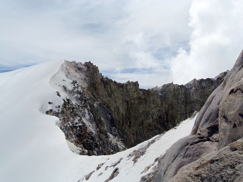
Pico de Orizaba.The volcano''s crater is elliptical with a transverse diameter measuring 478 m and a conjugate diameter measuring 410 m. The crater has an estimated 154,830 m2 with a maximum depth of 300 m. Pico de Orizaba is constantly covered by an ice cap consisting of several glaciers. An outlet glacier, known as Jamapa Glacier is located on the northeastern side of the peak; it has been a powerful force in shaping the volcano. The Jamapa Glacier is responsible for a significant portion of the geomorphologic evolution of the region surrounding the volcano. http://en.wikipedia.org/wiki/Volc%C3%A1n_Citlalt%C3%A9petl |
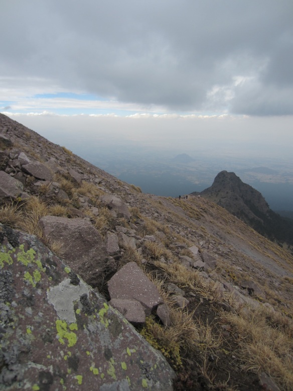
The broad ridge on the horizon is Las Cumbres volcanic complex, a Quaternary center NNE of Pico de Orizaba. A 3.5-4.5 km wide summit caldera of late-Pleistocene age is narrowly breached to the east, in the direction of this photo. The Las Cumbres complex lies in the southern half of the Pico de Orizaba-Cofre de Perote volcanic chain and is topographically much less prominent than the two major volcanoes anchoring the ends of the chain.Photo by Lee Siebert, 1998 (Smithsonian Institution). |
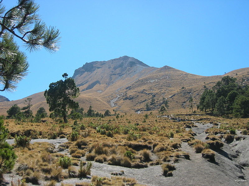
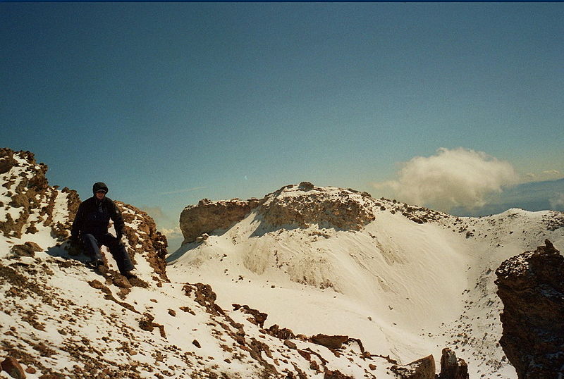
Las Cumbres, summit elevation 3940 m, stratovolcano . The volcano is situated in the Citlaltepetl¢Cofre de Perote Volcanic Range which forms a 70-km long, nearly N¢S trending chain that includes several large stratovolcanoes, minor cinder cones, and a few silicic domes. It is part of a N¢S trend with the Cerro Deconocido¢Las Cumbres¢Citlaltepetl volcanoes. A 4.5 km x 3.5 km caldera contains a lava dome in the centre. The morphology of the summit area suggests an origin related to an explosive caldera. This feature has also been interpreted as a horseshoe-shaped amphitheater formed by a catastrophic collapse and later filled in with a dacite lava dome that extends to a height above the breached rim.There are explosion craters and lava domes located north and south of the volcano. The volcano has been eroded by glaciers.Eruption 3920 BC. http://www.volcanolive.com/cumbres.html The Las Cumbres volcanic complex, a Quaternary center about 15 km NNE of Pico de Orizaba, contains a 3.5-4.5 km wide summit caldera narrowly breached on the east side. A dacitic lava dome (Cerro Gordo or El Cumbre Grande) lies in the center of the caldera. A group of monogenetic cones, explosion craters, and andesitic and rhyolitic lava domes is located north and south of Cerro las Cumbres. Three of these, Xalista and El Rodeo to the north, and Ixetal to the south, are obsidian domes. A major rhyolitic explosive eruption producing the Quetzalapa Pumice about 20,000 years ago originated from a vent on the lower NW flank of the Las Cumbres complex. Eruptive activity at the main Las Cumbres complex ceased during the late Pleistocene, although activity on the flanks of the edifice continued into the Holocene. The rhyolitic Yolotepec lava dome, north of Las Cumbres, has been radiocarbon dated at about 5900 years before present http://www.volcano.si.edu/world/volcano.cfm?vnum=1401-098 The flat-topped summit of Las Cumbres volcanic complex, a Quaternary volcano NNE of Pico de Orizaba, is seen here from the NW, across the Serdßn-Oriental basin. A 3.5-4.5 km wide summit caldera is partially filled by the Cerro Gordo lava dome. At least one of a group of monogenetic cones, explosion craters, and andesitic and rhyolitic lava domes on the flanks of the volcano is of Holocene age Photo by Lee Siebert, 1997 (Smithsonian Institution). |
Las Derrumbadas, Elevation: 1500 m, located 200km East of Mexico City in Serdan Basin. Twin Rhylotic domes. Age of 10-40 KA. Fumaroles at summit and extensive alteration of summit rocks. Surrounded by multiple avalanche aprons, formed during growth of structure, shedding of obsidian carapace, and oversteepening of structure - http://volcano.oregonstate.edu/vwdocs/volc_images/north_america/mexico/lasderrumbadas.html |
Las Derrumbadas, twin rhyolitic domes. |
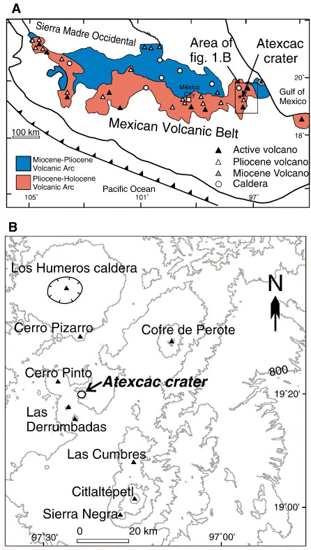
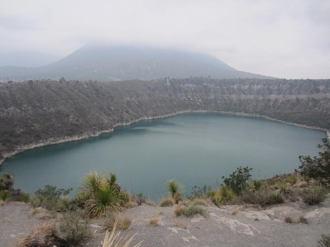
Atexcac crater lake.The Atexcac maar is located in the central part of the Serdan¢Oriental lacustrine/playa basint. It is part of a dispersed and isolated monogenetic field consisting of maar volcanoes, basaltic cinder cones and rhyolitic domes. Atexac is a maar volcano excavated into pyroclastic deposits, basaltic lava flows and the flanks of a cinder cone cluster, which itself was built on a topographic high consisting of limestone. It has an ENE-trending elliptical shape with beds, mostly unconsolidated deposits that dip outward at 16¢22o. The Atexcac crater was formed from vigorous phreatomagmatic explosions in which fluctuations in the availability of external water, temporal migration of the locus of the explosion, and periodic injection of new magma were important controls on the evolution of the maar crater. Variations in grain sizes and component proportions of correlated deposits from the different sections suggest a migration of the locus of explosions, producing different eruptive conditions with fluctuating water¢magma interactions. Deposits rich in large intrusive and limestone blocks are associated with a matrix enriched in small andesitic lapilli. This could suggest differential degrees of fragmentation due to inherited (previously acquired) fragmentation and/or relative distance to the locus of explosions. Initial short-lived phreatic explosions started at the southwest part of the crater and were followed by an ephemeral vertical column and the influx of external water that led to relatively shallow explosive interactions with the ascending basaltic magma. Drier explosions progressed downward and/or laterally northward, sampling subsurface rock types, particularly intrusive, limestone and andesitic zones as well as localized altered zones (N-NE), caused by repetitive injection of basaltic magma. A final explosive phase involved a new injection of magma and a new influx of external water producing wetter conditions at the end of the maar formation. We infer the aquifer was formed by fractured rocks, predominantly andesitic lava flows and limestone rocks. Andesitic accessory clasts dominate in all stratigraphic levels but these rocks are not exposed in the nearby area. These local hydrogeological conditions contrast with those at nearby maar volcanoes, where the water for the magma/water interactions apparently mostly came from a dominantly unconsolidated tuffaceous aquifer, producing tuff rings with a much lower profile than Atexcac. http://www.sciencedirect.com/science/article/pii/S0377027306003106 |
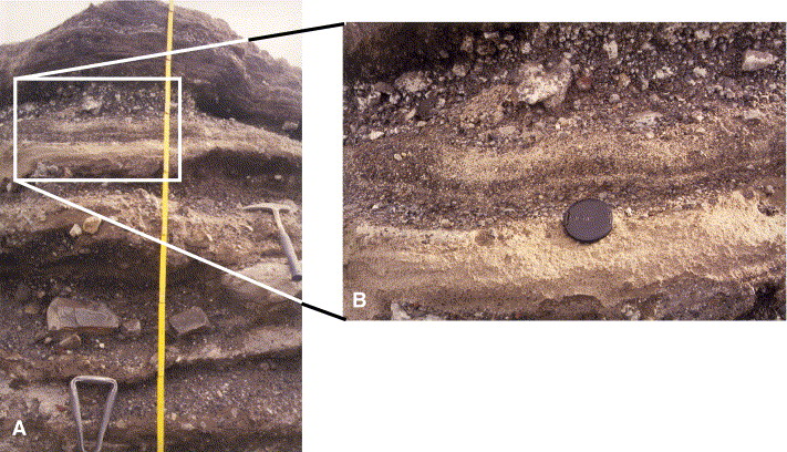
Evolution and hydrological conditions of a maar volcano (Atexcac crater).Photographs of the upper part of unit IV. A) Alternation of thin hard clay tuff (surge) layers and clast-supported, poorly sorted lapilli breccia with a few larger boulders. B) Detail of photo A showing an accretionary lapilli-rich indurated layer -http://www.sciencedirect.com/science/article/pii/S0377027306003106 |
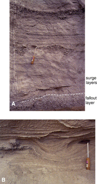
Photographs showing characteristic structures found in unit I. A) Base of unit I showing the well-sorted scoria-rich fallout deposit, underlying a subtly layered sequence comprising sandwave ash tuff interbedded with coarse sand-sized beds, in some cases filling small channels. B) Planar and cross-bedded layers and channels in unit I. Trowel is 22 cm long http://www.sciencedirect.com/science/article/pii/S0377027306003106 |
Cerro Pintois a dome/tuff ring complex that was apparently short lived, but went through some odd permutations in the process. Unlike most tuff rings, emplacement was dominantly by fall rather than surge. Although the on-going eruption of Soufriere Hills has taught us a lot about dome volcanism, we still don''t know much about how isolated domes erupt, and how their products may be distributed, whether effusive or explosive. Cerro Pizarro is in the eastern part of the Trans-Mexican Volcanic Belt, a zone that is world-renown for its active volcanoes, especially the stratovolcanoes [Colima, Citlalteptl (Orizaba), Popoceteptl (Popo)], some of which tower over major cities. The lowlands around the isolated domes we are studying are not heavily populated, but it is unwise to assume particular population movements when major cities are threatened by active volcanism. Theses that have been completed in the last several years on the Mexican domes are a study of vent processes based on analysis of pumice (Siobhan McConnell, 2004), a comparative study of remotely sensed data on surge and fall deposits from Cerro Pinto and from a dome complex in the Superstition Mountains near Phoenix (Christina Jan, 2005), and a physical-volcanology study of Cerro Pinto dome (Brian Zimmer, 2007). Matt Schmidt will start in F08, looking at Las Aguilas, and from there we will potentially do a study of Las Derrumbadas dome and move westward, where many more rhyolite domes are exposed near San Luis Potosi. Theses from mapping to pumice studies to conduit-process speculations are possible- http://jan.ucc.nau.edu/~nrr/mex.html http://nau.edu/uploadedFiles/Academic/CEFNS/NatSci/SESES/Forms/Zimmer_2007.pdf |
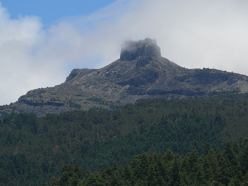
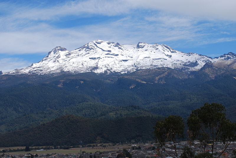
Cofre de Perote, Cordillera Neovolcanica, 4,282 m, last eruption 1150 +/- 150 years ago is extinct volcano is located in the Mexican state of Veracruz, at the point where the Trans-Mexican volcanic belt, home to all of Mexico''s highest peaks, joins the Sierra Madre Oriental. This volcano is shaped very differently from the strato-volcanic Pico de Orizaba, which lies to the south of it, being broad and shield-shaped. A cofre is a ''coffer'', and the name alludes to a volcanic outcropping like a boss on the shield, which constitutes the peak of the mountain. It is outlined against the clouds in the information-box picture, and is easily visible in the picture below. Cofre de Perote is also the name of a Mexican national park where the volcano is located http://en.wikipedia.org/wiki/Cofre_de_Perote |
Cofre de Perote, Cordillera Neovolcanica. Shield volcano, Citlaltepetl¢Cofre de Perote Volcanic Range consists of numerous volcanic centers along a 70 km long N¢S trending chain that includes several large stratovolcanoes, minor cinder cones, and a few silicic domes. Cofre de Perote is the northernmost volcano in the chain.Basaltic cinder cones are located on the NE flank, from which lava flows have traveled eastward to the major city of Xalapa (Jalapa). Debris Avalanches: The summit of Cofre de Perote volcano contains a prominent set of scarps that may be linked to repetitive flank failures. Two large debris avalanches have been identified at the volcano - Xico avalanche, and Los Pescados avalanche. Both avalanches resulted from flank failures directed to the SE. Xico avalanche:The avalanche occurred 10 KA and was most likely caused by earthquake activity of heavy rainfall, not by an eruption. Deposits extend 20 km from the summit. Los Pescados avalanche: The avalanche occurred 26 KA. The deposit forms the lowermost channel-filling terrace deposit of Los Pescados River, and consists of mixture of boulders and coarse gravels. Eruption 1150. http://www.volcanolive.com/mexico.html |
Evolutionary stages of Cofre: A) initial formation of the basal volcanic |
Cerro Pizarro (CP) is a 220ka, isolated rhyolitic dome in the eastern Trans-Mexican Volcanic Belt. A five-part evolution of the complex comprises: 1) Initial dome-growth. A rising body of magma intruded into an older terrain of Cretaceous limestone overlain by Tertiary and Quaternary volcanic rocks. Early deposits contain abundant material derived from older, buried units and are interpreted as vent-clearing deposits. 2) Explosive phase. As the early dome grew, explosive eruptions deposited thin fall and surge units; dome growth was also accompanied by minor Merapi-type collapse events. A dense lava interior was surrounded by a vitrophyric layer. 3) Cryptodome stage. Continued expansion of the dome caused deformation of the earlier overlying units to orientations as steep as vertical or slightly overturned. This phase of dome growth was entirely endogenous and demonstrates how cryptodomal dome growth can affect dome facies as well as flat-lying country rock. 4) Sector collapse. The fourth phase of dome evolution involved Mount St. Helens-like sector collapse, a phenomenon rarely seen in domes. Rocks representative of all previous phases of dome evolution are preserved in breccias of the debris-avalanche deposit. 5) Final dome growth and eruption. The present shape of the volcano is conical, mimicking the cryptodome. Minor pyroclastic material from the final phase drapes the slopes of the volcano and coalesced into flows that lapped up against surrounding topography. Chemistry of material representing various stages of this succession is generally homogeneous, and together with soft-sediment deformation seen in pre-CP units that were affected by cryptodomal deformation, suggests that the timing of the first four stages of volcano evolution was relatively short. Deposits from stage 5, however, overlie the Zaragoza Ignimbrite derived from Los Humeros caldera to the north, suggesting that the last eruptive episode occurred somewhat later. Dome growth and destruction is generally considered in the context of larger systems in which domes often occur. The history of CP indicates that processes like sector collapse common to larger stratovolcanoes occur in smaller, more isolated systems as well, and that even in the absence of a larger magmatic system, dome growth may be a highly complex process https://gsa.confex.com/gsa/2001AM/finalprogram/abstract_23121.htm |
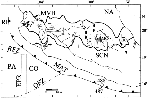
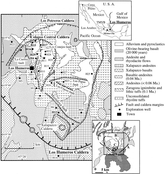
PA ¢ pacific plate, NA ¢North American Plate, LHC - Los Humeros Caldera |
The caldera system is composed of the Los Humeros Caldera. Geochemistry of Pliocene to recent volcanic rocks from Los Humeros caldera in East-Central mexico is described. The volcanic rocks from this area seem to represent both alkali and high-alumina basalt series, or both calcalkaline and high-K calc-alkaline sequences. The available bulk-chemical analyses (23 this study and 18 from unpublished literature) show that the entire sequence of rocks from basalts to rhyolites are present in this area. Different degrees of partial melting of the source region followed by extensive shallow-level crystal differentiation seem to have taken place before most volcanic eruptions. These processes are perhaps the most important mechanisms for magma genesis in Los Humeros caldera. Geophysical studies in this area are not sufficient and more detailed geophysical surveys and a better geological interpretation are needed in order to delimit the underlying magma chamber http://rd.springer.com/article/10.1007/BF02600390 |
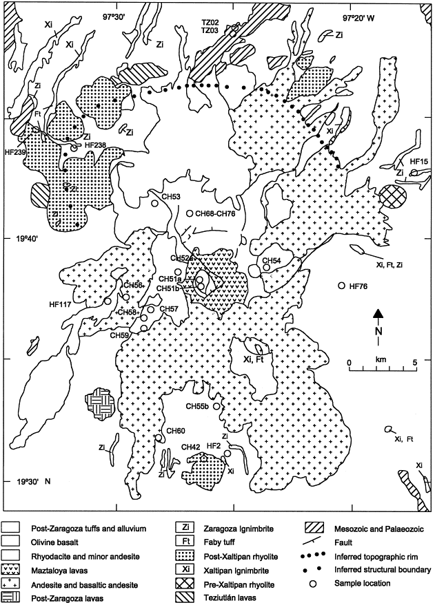
Los Humeros Caldera geomap. Los Humeros Caldera, summit elevation 3150 m, Los Humeros volcanic center is located near the east end of the Mexican Neovolcanic Belt, 55 km west-northwest of the city of Xalapa, Veracruz. The Los Humeros caldera is about 400 m deep and is irregularly circular with a diameter 21 km x 15 km.Los Humeros caldera was formed in a large eruption 460 KA. A second caldera was formed 100 KA and was followed by a third caldera formation 20-40 KA. Geothermal activity is present at the volcano. Fumarolic activity and sulfur deposits are observed in the oval-shaped La Calderita crater located in the southern part of Los Humeros caldera. This caldera formed as a result of the collapse of the root of the magma chamber.Los Humeros magma is broadly similar in chemical composition to those from other areas of the Mexican volcanic belt. There are small differences are however apparent for some elements. Los Humeros basalts have higher MgO and lower K2O. Basaltic andesites from Los Humeros are richer in Al2O3 whereas andesites show higher TiO2 and lower MgO. Dacites and rhyolites from Los Humeros have considerably lower FeO than those from other areas of the Mexican Volcanic Belt. Eruptions at Los Humeros Volcano: 1) Silicic volcanism began at Los Humeros volcano 47,000 years ago with extrusion of high-silica rhyolite domes. 2) This was followed by eruption of 115 cubic km of magma 47,000 years ago, forming the Xaltipan Ignimbrite. Pyroclastic flows covered 3500 sq km, and descended to an elevation of 1900 m over a distance of 50 km. The Xaltipan Ignimbrite is covered by a co-ignimbrite ash-fall deposit, which is covered by eight air-fall lapilli tuffs. Eruption of the Xaltipan Ignimbrite led to collapse of the Los Humeros caldera. Several high-silica rhyolite domes were emplaced after caldera collapse at or close to the inferred Los Humeros ring-fracture zone.3) Faby Tuff was erupted 24,000 years ago, producing 10 cubic km of lava, and airfall deposits. 4) Zaragoza Tuff erupted 12 cubic km of lava 100,000 years ago. This led to the collapse of the 10-km diameter Los Potreros caldera, which is nested within the older Los Humeros caldera. 5) Xoxoctic Tuff erupted 50,000 years ago. 6) Between 40,000 and 30,000 years ago, an arc of andesitic scoria cones formed along the southern ring-fracture zone of the Los Humeros caldera. These deposits are covered by Cuicuiltic Tuff. This was followed by collapse of the 1-7-km diameter El Xalapazco caldera.7) Eruptions continued at Los Humeros Volcano until 20,000 years ago, with emission of small volumes of olivine basalt erupted along the southern ring-fracture zone of the Los Humeros caldera and on the floors of the Los Potreros and El Xalapazco calderas. http://www.volcanolive.com/humeros.html |
La Malinche mountain, Cordillera Neovolcanica, Cordillera Anahuac Range, this volcano is part of the Trans-Mexican Volcanic Belt. Officially, its summit reaches 4,461 m above sea level, though in some articles it is considered to be 4,503 m (as measured by GPS). The climate is cold on the summit and mild on its lower slopes. La Malinche mountain, also called Malintzi by the locals, is an inactive stratovolcano which began to form in the middle of the Paleogene period, 30-35 MA. Since that time it has grown through eruptions, some violent and some gentle. The last eruption is believed to have occurred 3182 years ago. This volcano is a cone with extensive slopes. At the foot of this mountain are some other summits, like Xaltonele peak, Xalapaxco crater and the 450 m Cuatlapanga; the latter is a famous summit. At present, La Malinche is apparently quiet, although some "strange noises" have been reported by local residents. On lower slopes are farmlands which grow mostly field "dent" corn and forests which transition from oak to oyamel with increasing elevation. The upper slopes are grasslands. The summit is covered by snow part of the year and is considered to be the coldest location in Tlaxcala. On the lower slopes the climate is mild year round, but rainy during the summer months. The soils consist of crushed volcanic rock and sand with an underlying layer of clay and sand called tepetate at an average depth of about a meter. The dark and porous forest soils were formed from volcanic ash. From La Malinche streams flow in all directions forming small gorges in places which fill and run rapidly when torrential rains occur. At the base of the mountain emerge many springs, some of drinkable water, and others of thermal water heated in the volcano''s interior.http://en.wikipedia.org/wiki/Matlalcueitl_(volcano) La Malinche, summit elevation 4503 m, stratovolcano, located 110 km SE of Mexico City, in the eastern central part of the Trans-Mexican Volcanic Belt. The volcano contains a several dacitic domes at the summit and lacks a summit crater. A small parasitic crater (Atitlan) is situated on La Malinche''s western flank, and a larger and more eroded crater is located on the eastern flank, near the summit. La Malinche is strongly eroded and last erupted about 3100 years ago. Partial sector collapse occurred at the volcano 21 KA. Eruptions at La Malinche volcano consist of plinian eruptions which last days to weeks, followed by longer intermittent episodes of pyroclastic flow activity caused by dome collapse. http://www.volcanolive.com/mexico.html |
La Malinche |
La Malinche |
La Malinche |
Iztaccihuatl, Cordillera Neovolcanica, 5286m is a 5,230 m mountain. The name "Iztaccнhuatl" is Nahuatl for "White woman", reflecting the four individual snow-capped peaks which depict the head, chest, knees and feet of a sleeping female when seen from east or west.Iztaccнhuatl lies to the north of Popocatepetl, to which it is connected by the high altitude Paso de Cortйs. Depending on atmospheric conditions the dormant volcano is visible much of the year from Mexico City some 70 km to the northwest.The first recorded ascent was made in 1889, though archaeological evidence suggests the Aztecs and previous cultures climbed it previously. It is the lowest peak containing permanent snow and glaciers in Mexicohttp://en.wikipedia.org/wiki/Iztaccihuatl The volcano began eruptions 1.5 MA, and the volcano have produced pyroclastic material and lava flows. The volcano contains a glacier (Ayoloco) covering 21 ha in 2000. Studies of this glacier can give an indication of global warming at this latitude. |
Iztaccihuatl, the summit ridge of the massive 450 km3 volcano is a series of overlapping cones constructed along a NNW-SSE line to the south of the Pleistocene Llano Grande caldera. Andesitic and dacitic Pleistocene and Holocene volcanism has taken place from vents at or near the summit. Areas near the El Pecho summit vent are covered in flows and tuff beds post-dating glaciation approximately 11 ka . The most recent vents are located at El Pecho and a depression at 5,100 m along the summit ridge midway between that summit and Los Pies http://en.wikipedia.org/wiki/Iztaccihuatl |
Iztaccihuatl and Popocatepetl -http://manxodoarte.blogspot.com/2012/06/volcanes-de-mexico.html |
Popocatepetl,http://manxodoarte.blogspot.com/2012/06/volcanes-de-mexico.html |
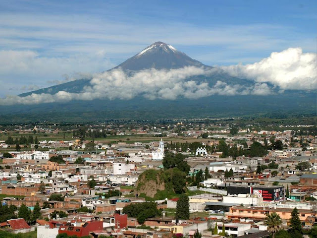
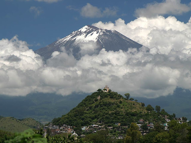
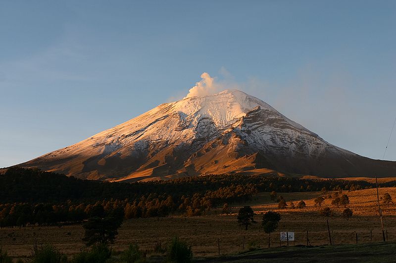
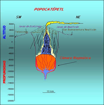
Popocatepetl, Cordillera Neovolcanica, from Amecameca (looking south-east) Popocatepetl is an active volcano located in the states of Puebla, State of Mexico, and Morelos, in Central Mexico, and lies in the eastern half of the Trans-Mexican volcanic belt. At 5,426 m. Popocatepetl is linked to the Iztaccihuatl volcano to the north by the high saddle known as the Paso de Cortes. Popocatepetl is 70 km southeast of Mexico City, from where it can be seen regularly, depending on atmospheric conditions. Until recently, the volcano was one of three tall peaks in Mexico to contain glaciers, the others being Iztaccihuatl and Pico de Orizaba. In the 1990s, the glaciers such as Glaciar Norte (North Glacier) greatly decreased in size, partly due to warmer temperatures but largely due to increased volcanic activity. By early 2001, Popocatepetl''s glaciers had become extinct; ice remained on the volcano, but no longer displayed the characteristic features of glaciers such as crevasses. Magma erupting from Popocatepetl has historically been predominantly andesitic, but it has also erupted large volumes of dacite. Magma produced in the current cycle of activity tends to be a mixture of the two. The stratovolcano contains a steep-walled, 400 Ч 600 m wide crater. The generally symmetrical volcano is modified by the sharp-peaked Ventorrillo on the NW, a remnant of an earlier volcano. At least three previous major cones were destroyed by gravitational failure during the Pleistocene, producing massive debris avalanche deposits covering broad areas south of the volcano. The modern volcano was constructed to the south of the late-Pleistocene to Holocene El Fraile cone. Three major plinian eruptions, the most recent of which took place about 800 AD, have occurred from Popocatepetl since the mid Holocene, accompanied by pyroclastic flows and voluminous lahars that swept basins below the volcano. According to paleomagnetic studies, the volcano is about 730,000 years old. Elevation 5,450 m in cone form with a diameter of 25 km at its base and the crater has an elliptical shape with an orientation northeast-southwest. the walls of the crater vary from 600 to 840 m in height. Popocatepetl is currently active after being dormant for about half of last century. In 1991 the volcano''s activity increased and since 1993 smoke can be seen constantly emanating from the crater http://en.wikipedia.org/wiki/Popocat%C3%A9petl Eruptions2011-12, 2007-2009, 2005, 1996-2003, 1994-95, 1947, 1942-43, 1933, 1923-24, 1920-22, 1852, 1827-34, 1802-04, 1720, 1697, 1663-67, 1642, 1592-94, 1590, 1580, 1571, 1548, 1542, 1539-40, 1530, 1528, 1519-23?, 1518, 1512?, 1509?, 1504, 1488, 1363, 1354, 1345-47. |
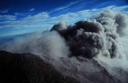
Popocatepetl, explosion, Cordillera Neovolcanica |
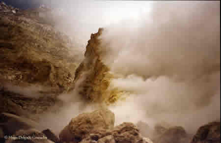
Popocatepetl -(H2O), (CO2) , (SO2), 1994, crater |
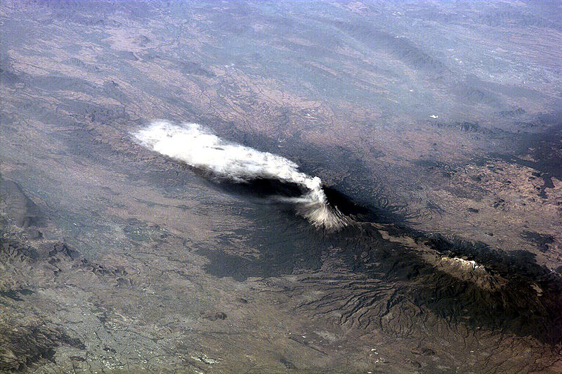
Popocatepetl, or Popo, 5426m, 2012 the active volcano located about 70 km southeast of Mexico City, sends a plume south on January 23, 2001. The astronaut crew on the International Space Station Alpha observed and recorded this image as they orbited to the northeast of the volcano. Popo has been frequently active for six years. On this day, the eruption plume reportedly rose to more than 9 km above sea level [for reference, PopoÆs summit elevation is 5426 m. Note the smaller ash plume below the main plume (arrow). The perspective from the ISS allowed the astronauts this unique 3 dimensional view.Recent eruptions have been frequent, and have resulted in evacuations around the mountain.http://eol.jsc.nasa.gov/scripts/sseop/photo.pl?mission=ISS001&roll=E&frame=5316 Earth Sciences and Image Analysis Laboratory, Johnson Space Center. http://eol.jsc.nasa.gov/ |
Popocatepetl is one of the most active volcanoes in Mexico, having had more than 15 major eruptions since the arrival of the Spanish in 1519. A major eruption occurred in 1947.On December 21, 1994, the volcano spewed gas and ash which was carried as far as 25 km (16 mi) away by prevailing winds. The activity prompted the evacuation of nearby towns and scientists to begin monitoring for an eruption.In December 2000, tens of thousands of people were evacuated by the government based on the warnings of scientists. The volcano then made its largest display in 1,200 years.On December 25, 2005, the volcano''s crater produced an explosion which ejected a large column of smoke and ash about 3 km (1.9 mi) into the atmosphere and expulsion of lava.In January and February of 2012, scientists have been noticing Popocatepetl''s action increasing. On January 25, 2012, an ash explosion occurred on the mountain causing much dust and ash to contaminate the atmosphere around it. On April 19, 2012 there were reports of superheated rock fragments being hurled into the air by the volcano. Ash and water vapor plumes were reported 15 times over 24 hours http://en.wikipedia.org/wiki/Popocat%C3%A9petl |
Popocatepetl - http://www.geofisica.unam.mx/popoc/informacion/monitorgases.php |
Deeposits of piroclastica 1,300 BP of Popocatepetl. |
Jocotitlan Volcano, summit elevation 3900 m, stratovolcano is an isolated composite volcano located in the central part of the Trans Mexican Volcanic Belt, which is an E-W structure extending 1500 km from the Pacific coast to the coast of the Gulf of Mexico. The volcano rises about 1300m above the floor of the northern Toluca Basin. The morphology of Cerro Jocotitlfin is intermediate between that of a typical stratovolcano and a dome complex. The lower elevations have shallow dips and an overall concave-upward surface in contrast with the upper flanks which consist of a much steeper convex-upward profile. A catastrophic collapse of the northeastern flanks of Cerro Jocotitlan led to the formation of a breached crater with a 90 deg sector opened to the NE. The avalanche deposit covers an area of 80 sq km, has a maximum runout distance of 12 km. Eruptions 1270 +/- 75, 7740 BC+/- 75 http://www.volcanolive.com/jocotitlan.html One of its most prominent features is a horseshoe-shaped escarpment visible from the northeast; it formed when the northeast edge of the caldera collapsed. Whenever this event happened, it created an enormous landslide that buried 80 km2 of land to the northeast of the volcano.Jocotitlan formed in the Pleistocene era (11 KA to 1.8 MA) primarily out of andesitic-to-dacitic lava flows. After that there was an obsidian dacitic eruptino and then the creation of a lava dome complex. The volcano produced regular lava flows, pumice-fall eruptions and pyroclastic surges. The last known eruption at Jocotitlan happened about 700 years ago, and produced block-and-ash flows and pyroclastic surges. |
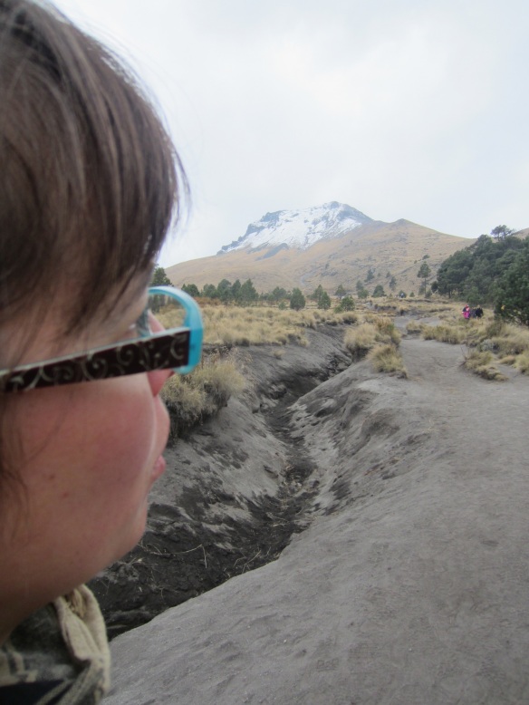
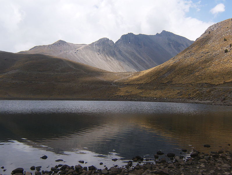
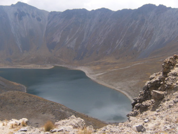
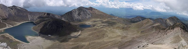
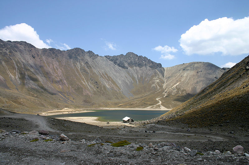
Nevado de Toluca , Cordillera Neovolcanica, 4690m, 1350BC is a large stratovolcano in central Mexico, located about 80 km west of Mexico City. The volcano has a 1.5 km summit caldera which is open to the east. The highest summit, 4,680 m Pico del Fraile (Friar''s Peak), is on the southwest side of the crater and the second highest, 4,640 m Pico del Aguila (Eagle''s Peak), is on the northwest. There are two crater lakes on the floor of the basin at about 4,200 m, the larger Lago del Sol (Sun Lake) and the smaller, but deeper, Lago de la Luna (Moon Lake). A road formerly ran into the caldera to the lakes, making this perhaps the most accessible major Mexican peak. The road is now gated 2 km before the lakes.The last major eruption of Nevado de Toluca occurred in 10.5 ka BP, as the volcano erupted a total estimated volume of 14 km3 for a VEI strength of 6 (comparable to the 1991 eruption of Mount Pinatubo). The eruption emplaced 1.5 m of pebble-sized pumice in the City of Toluca region and 50 cm of medium to fine sand in the Mexico City region. Distal lahar deposits derived from the Upper Toluca Pumice event incorporated mammoth bones and other mammals in the basin of Mexico. A future event of this magnitude would disrupt the lives of 30 million people now living in these cities and their surroundings.From the southeast, Nevado de Toluca looks flat-topped, like shoulders without a head http://en.wikipedia.org/wiki/Nevado_de_Toluca |
Nevado de Toluca. Moon Lake |
Nevado de Toluca. Lago de Sol |
Nevado de Toluca, last eruption 1350 BC (?) |
Nevado de Toluca |
The massive Chichinautzin volcanic field covers a 90-km-long, E-W-trending area immediately south of Mexico City. The Sierra Chichinautzin, formed primarily of overlapping small cinder cones and shield volcanoes, creates a broad topographic barrier at the southern end of the Basin of Mexico that extends from the eastern flank of Nevado de Toluca to the western flank of Iztaccнhuatl volcano. The volcanic field contains more than 220 Pleistocene-to-Holocene monogenetic vents. The best-known eruption occurred about 1670 radiocarbon years ago from the Xitle scoria cone, NE of the Volcбn Ajusco lava-dome complex, which at 3930 m forms the highest peak of the Sierra Chichinautzin. The Xitle eruption produced a massive basaltic tube-fed lava flow that covered agricultural lands as well as pyramids and other structures of Cuicuilco and adjacent prehispanic urban centers. The southern part of Mexico City and the National University of Mйxico lie atop the distal end of the 13-km-long lava flow -http://explorevolcanoesnow.com/american-volcanoes/mexico/chichinautzin-mexico/ |
Chichinautzin volcanic field .The volcano consists of cinder cones and shield volcanoes. A 13 km long lava flow reaches Mexico City. The volcanic field extends over a length of 90 km. Sierra Chichinautzin Volcanic Field is located at the southern limit of the Mexico Basin, and is situated between two stratovolcanoes: Popocatepetl and Nevado de Toluca. Eruptions at the volcano have produced pyroclastic deposits from Strombolian activity, although a few have characteristics of Surtseyan-type eruptions. The activity that produced lava cones may be transitional to Hawaiian-type eruptions. |
Crater of Chichinautzin (Cynthia Barrera) |
Cynthia-Barrera.The lengths of lava flows range from 1 to 21.5 km with thicknesses between 0.5 m and 300 m. Cone heights range from 10 to 315 m and diameters from 50 to 750 m. The volcanic field contains Tlaloc, Tlacotenco, Cuauhtzin, Hijo del Cuauhtzin, Teuhtli, and Ocusacayo monogenetic volcanoes. There are also almost 200 cones which are both scoria and hydromagmatic. There are 10 lava domes in the field -http://explorevolcanoesnow.com/american-volcanoes/mexico/chichinautzin-mexico/ |
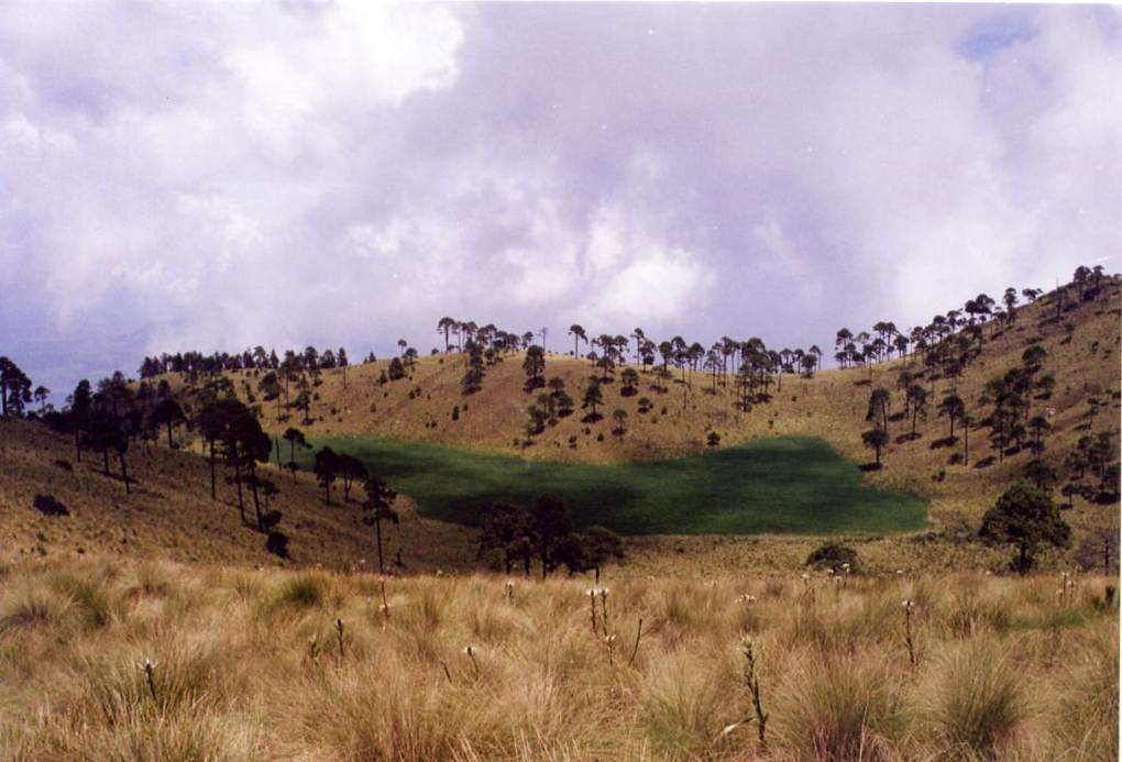
Sierra del Ajusco-Chichinauhtzin Milpa Alta presents a heavily mountainous relief. Its lowest point, San Antonio Tecomitl, has an altitude of 2250 m above sea level. Surrounding Teuhtli volcano there is a strip of land slightly sloped that gradually becomes higher moving west. This region is known as the Milpa Alta valley- little valley separates the Teuhtil volcano from the Ajusco-Chichunautzin mountains, that takes its name from its highest peaks. The Ajusco-Chichinauhtzin mountains constitutes the highest region with peaks above 3,500 m above sea level. This is then the highest region of the borough, and the tallest point is at the summit of Tlaloc volcano, with 3,690 m above the level of the sea. Along this mountain chain the following volcanos are placed: Cauhtzin, Chichinauhtzin, Tetzcacoatl, Acopiaxco, San Bartolo and Ocusacayo, all of which are above 3,100 m.The Ajusco-Chichinauhtzin range emerged after violent volcanic activity during the cuaternarian period; in other words, this means that the surface of Milpa Alta is reasonably young in terms of geologic time. Before the emergence of this wall of mountains, the Valley of Mexico basin had natural drainage to the Balsas river. The entirety of the territory of Milpa Alta is part of the geologic subprovince of Lakes and Volcanoes of Anahuac, in turn corresponding to the province of the Neovolcanic Axis. The topoforms included in the borough are the Sierra Volcanica with stratovolcanoes -more than 95% of the land area- and the basaltic tableland. This one is only present in small portions to the East of the borough and a strip placed near the Cuahtzin and Teuhtli volcanoes. As over 96% of Milpa Alta''s surface is product of geologic activity of the Quaternary, the greater part of its 230 km2 is covered in some sort of volcanic rock, specially basalt (35% of the land surface) and tuff. Less than 2 kmІ of territory are covered by an alluvial soil type. The geologic zone of this characteristic is localized to the East of the Villa Milpa Alta, and is part of the same-named valley. To the north of the valley there is the Teuhtli volcano. This is the oldest part of the borough, as it emerged in the Tertiary period. It is a peculiar (and inactive) shield volcano with an ash cone, made up by Andesite. Tlaloc (3,690 m), Pelado (3,620 m), Cuautzin (3,510 m) and Chichinautzin Cauhtzin, Chichinauhtzin, Tetzcacoatl, Acopiaxco, San Bartolo and Ocusacayo, all of which are above 3,100 m -http://fieldguides.gsapubs.org/content/25/163.abstract |
Ajusco, Cordillera Neovolcanica is a 3,930 m located just south of Mexico City. Ajusco is a lava-dome complex of Pliocene-Pleistocene age, surrounded by block-and-ash flow deposits. Ajusco is part of the mountain chain of volcanic origin known as Sierra del Ajusco-Chichinauhtzin, among which Xitle (3,128 m/), Tlaloc (3,690 m), Pelado (3,620 m), Cuautzin (3,510 m) and Chichinautzin (3,470 m) stand out. This range is part of the Trans-Mexican Volcanic Belt which crosses central Mexico and contains the country''s highest peaks http://en.wikipedia.org/wiki/Ajusco |
Teuhtli |
Cerro Tlaloc |
The Aztec observatory on TlalocÆs summit -http://www.climb.mountains.com/Classic_Peaks_files/Desert_Classics_files/Mexico98.shtml |
Pelado. Holocene Pelado, Guespalapa and Chichinautzin monogenetic scoria cones and associated lava flows located within the Sierra del Chichinautzin Volcanic Field (SCVF) at the southern margin of Mexico City were mapped and sampled for mineralogical and chemical analyses. With the exception of Parэcutin volcano in western Mexico, few scoria cones in the Trans-Mexican Volcanic Belt have ever been sampled in greater detail. Chemical analyses of rocks indicate that mafic products (e.g. Guespalapa and Chichinautzin) from individual volcanoes in the Sierra del Chichinautzin are characterized by substantial chemical variability, whereas high-silica andesite volcanoes (e.g. Pelado) are very uniform in composition. These findings have important bearings for regional tephrochronology. As a whole, rock compositions form a continuous coherent calc¢alkaline suite, explicable by polybaric fractional crystallization▒assimilation associated with successive stagnation at different depths along the ascent path. Trace element and Sr¢Nd isotope analyses point toward a <1-km-scale heterogeneous (enriched/depleted) mantle wedge underneath the SCVF. The recently proposed plume-origin for these rocks is not in accord with our data. Instead, magma origin is discussed in relation to the tectonically complex subduction process of the oceanic Cocos Plate underneath the continental North American Plate. http://www.sciencedirect.com/science/article/pii/S0377027303002890 |
monogenetic volcanoes Pelado (P), Chichinautzin (Ch), and Xitle (X).Holocene Pelado, Guespalapa and Chichinautzin monogenetic scoria cones and associated lava flows located within the Sierra del Chichinautzin Volcanic Field (SCVF) at the southern margin of Mexico City were mapped and sampled for mineralogical and chemical analyses. With the exception of Parэcutin volcano in western Mexico, few scoria cones in the Trans-Mexican Volcanic Belt have ever been sampled in greater detail. Chemical analyses of rocks indicate that mafic products (e.g. Guespalapa and Chichinautzin) from individual volcanoes in the Sierra del Chichinautzin are characterized by substantial chemical variability, whereas high-silica andesite volcanoes (e.g. Pelado) are very uniform in composition. These findings have important bearings for regional tephrochronology. As a whole, rock compositions form a continuous coherent calc¢alkaline suite, explicable by polybaric fractional crystallization▒assimilation associated with successive stagnation at different depths along the ascent path. Trace element and Sr¢Nd isotope analyses point toward a <1-km-scale heterogeneous (enriched/depleted) mantle wedge underneath the SCVF. The recently proposed plume-origin for these rocks is not in accord with our data. Instead, magma origin is discussed in relation to the tectonically complex subduction process of the oceanic Cocos Plate underneath the continental North American Plate. http://www.sciencedirect.com/science/article/pii/S0377027303002890 |
Xitle is a volcano in the Ajusco range in Cumbres del Ajusco National Park. It is located in the Tlalpan borough in the southwestern part of Mexico City. It is an ash cone volcano with a conical form, round base, altitude of approximately 300m, and a slope between 30░ and 40░.Xitle registered its last eruption in 400. Among the consequences of this eruption were the formation of the Pedregal de San Бngel lava fields, to the south of the Mexican Federal District. Cuicuilco, one of the most refined cities of Mesoamerica was destroyed by one of Xitle''s eruptions in 50 BC and was covered by lava. The subsequent diaspora of the Cuicuilcans, and the attendant diffusion of their culture across most of central Mexico, influenced important cultural changes in the nearby power center of Teotihuacan. |
Xitle |
A Nearby Lateral Vent Of The Xitle Volcano |
Xitle |
Lava of volcano Xitle. To investigate the relationship between volatile abundances and eruption style, we have analyzed major element and volatile (H2O, CO2, S) concentrations in olivine-hosted melt inclusions in tephra from the ∼2000 yr BP eruption of Xitle volcano in the central Trans-Mexican Volcanic Belt. The Xitle eruption was dominantly effusive, with fluid lava flows accounting for ∼95% of the total dense rock erupted material (1.1 km3). However, in addition to the initial, Strombolian, cinder cone-building phase, there was a later explosive phase that interrupted effusive activity and deposited three widespread ash fall layers. Major element compositions of olivine-hosted melt inclusions from these ash layers range from 52 to 58 wt.% SiO2, and olivine host compositions are Fo84-86. Water concentrations in the melt inclusions are variable (0.2¢1.3 wt.% H2O), with an average of 0.45 wt.% H2O. Sulfur concentrations vary from below detection (50 ppm) to 1000 ppm but are mostly ≤200 ppm and show little correlation with H2O. Only the two inclusions with the highest H2O have detectable CO2 (310¢340 ppm), indicating inclusion entrapment at higher pressures (700¢900 bars) than for the other inclusions (<80 bars). The low and variable H2O and S contents of melt inclusions combined with the absence of less soluble CO2 indicates shallow-level degassing before olivine crystallization and melt inclusion formation. Olivine morphologies are consistent with the interpretation that most crystallization occurred rapidly during near-surface H2O loss. During cinder cone eruptions, the switch from initial explosive activity to effusive eruption probably occurs when the ascent velocity of magma becomes slow enough to allow near-complete degassing of magma at shallow depths within the cone as a result of buoyantly rising gas bubbles. This allows degassed lavas to flow laterally and exit near the base of the cone while gas escapes through bubbly magma in the uppermost part of the conduit just below the crater. The major element compositions of melt inclusions at Xitle show that the short-lived phase of renewed explosive activity was triggered by a magma recharge event, which could have increased overpressure in the storage reservoir beneath Xitle, leading to increased ascent velocities and decreased time available for degassing during ascent http://www.sciencedirect.com/science/article/pii/S0377027302004018 |
Geologic map of Xitle volcano and its deposits (based on Cervantes and Molinero, 1995, and Delgado et al., 1998). The area covered by lava flows from Xitle is shown by a heavy solid line. Within this area, individual lava flows are delimited by thin solid lines and identified by Roman numerals. The distribution of tephra deposits is shown by a dashed line that corresponds to the 0.1-cm isopach. Small open circles indicate the location where the three different tephra layers were sampled and are numbered according to which layer was sampled. The inset at upper left shows the location of Xitle volcano within the TMVB (dark gray). The stratigraphic relations of the different eruptive events from Xitle are shown in the lower right corner. Two columns are shown in this inset: the right one shows the field relationships of the explosive events and the surrounding lava flows; the column to the left shows the stratigraphic relations of lava flows III¢VI. The time of emplacement of tephra layers 1¢3 relative to emplacement of flows III¢VI is uncertain. Note that the numbering of the fall layers is contrary to the commonly used convention of numbering from base to top; we have retained this numbering to be consistent with previous studies ( and http://www.sciencedirect.com/science/article/pii/S0377027302004018 |
Guespalapa volcano |
Cuautzin - http://manxodoarte.blogspot.com/2012/06/volcanes-de-mexico.html |
Acopiaxco-http://peakery.com/get_panoramio_pics/254327/ |
Acopiaxco |
Colima Volcano, Cordillera Neovolcanica |
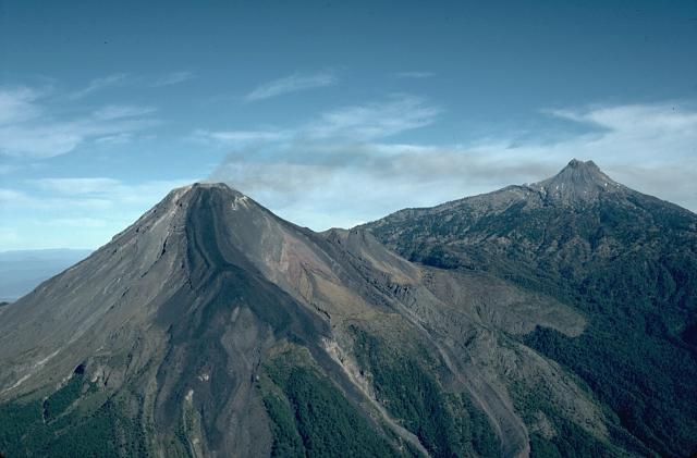
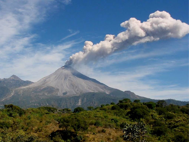
The Volcan de Colima, also known as Volcan de Fuego is part of the Colima volcanic complex consisting of Volcan de Colima and Nevado de Colima. It is the younger of the two and is currently one of the most active volcanos in Mexico and in North America. It has erupted more than 40 times since 1576. Nevado de Colima, also known as Tzapotepetl, lies 5 km north its more active neighbor and is the taller of the two at 4260m. It is the 26th most prominent peak in North America.Despite its name, only a fraction of the volcano''s surface area is in the state of Colima; the majority of its surface area lies over the border in the neighboring state of Jalisco, toward the western end of the Eje Volcanico Transversal mountain range. It is about 485 km west of Mexico City and 125 km south of Guadalajara, Jalisco.Since 1869-1878, a parasitic set of domes, collectively known as El Volcancito, have formed on the northeast flank of the main cone of the volcano http://en.wikipedia.org/wiki/4000_meter_peaks_of_Mexico#Highest_major_summits http://en.wikipedia.org/wiki/Colima_(volcano) |
Volcan de Colima is on the left with Nevado de Colima on the right, 4330m, 2009- continuing 2012. In recent years there have been frequent temporary evacuations of nearby villagers due to threatening volcanic activity. Eruptions have occurred in 1991, 1998¢1999 and from 2001 to the present day, with activity being characterised by extrusion of viscous lava forming a lava dome, and occasional larger explosions, forming pyroclastic flows and dusting the areas surrounding the volcano with ash and tephra.The largest eruption for several years occurred on May 24, 2005. An ash cloud rose to over 3 km over the volcano, and satellite monitoring indicated that the cloud spread over an area extending 200 km west of the volcano in the hours after the eruption. Pyroclastic flows travelled four-five km from the vent, and lava bombs landed 3¢4 km away. Authorities set up an exclusion zone within 6.5 km of the summit.On June 8, 2005, the volcano erupted again in its largest recorded eruption in several decades. Plumes from this eruption reached heights of 5 km above the crater rim, prompting the evacuation of at least three neighboring villages. http://en.wikipedia.org/wiki/Colima_(volcano) |
ōVolcan de Fuegoö de Colima -http://manxodoarte.blogspot.com/2012/06/volcanes-de-mexico.html |
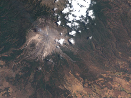
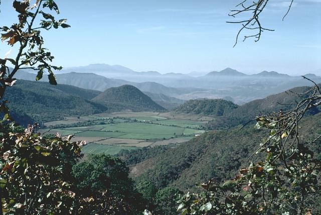
Snow-capped Colima Volcano, the most active volcano in Mexico, rises abruptly from the surrounding landscape in the state of Jalisco in the center of this false-color satellite image. Part of the trans-Mexican volcanic belt, Colima is actually a melding of two volcanoes, the older Nevado de Colima to the north and the younger, historically active Volcan de Colima to the south. Approximately 300,000 people live within 40 km of the volcano earning it designation as a Decade Volcano by the International Association of Volcanology and Chemistry of the Earth''s Interior. Legend has it that gods sit atop the volcano on thrones of fire and ice. For other active volcanoes in Mexico, see the Natural hazards-volcanism subfield in the Geography section. Image courtesy of USGS. http://www.eoearth.org/article/Mexico |
Mascota Volcanic Field |
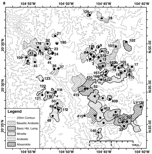
The Mascota volcanic field is located in the Jalisco Block of western Mexico, where the Rivera Plate subducts beneath the North American Plate. It spans an area of 2000 km2 and contains 87 small cones and lava flows of minette, absarokite, basic hornblende lamprophyre, basaltic andesite, and andesite. There are no contemporary dacite or rhyolite lavas. New 40Ar/39Ar ages are presented for 35 samples, which are combined with nine dates from the literature to document the eruptive history of this volcanic field. The oldest lavas (2.4 to 0.5 Ma) are found in the southern part of the field area, whereas the youngest lavas (predominantly < 0.5 Ma) are found in the northern portion. On the basis of these ages, field mapping, and the use of ortho aerial photographs and digital elevation models, it is estimated that a combined volume of 6.8 +/-3.1 km3 erupted in the last 2.4 Myr, which leads to an average eruption rate of ∼ 0.003 km3/kyr, and an average volume per eruptive unit of < 0.1 km3. The dominant lava type is andesite (2.1 +/- 0.9 km3), followed by absarokite (1.6 +/- 0.8 km3), basaltic andesite (1.2 +/- 0.5 km3), basic hornblende lamprophyre (1.0 +/- 0.4 km3), and minette (0.9 +/- 0.5 km3). Thus, the medium- andesite and basaltic andesite comprise approximately half (49%) of the erupted magma, with twice as much andesite as basaltic andesite, and they occur in close spatial and temporal association with the highly potassic, lamprophyric lavas. There is no time progression to the type of magma erupted. A wide variety of evidence indicate that the high-MgO (8¢9 wt.% ) basaltic andesites (52¢53% wt.% SiO2) were formed by H2O flux melting of the asthenopheric arc mantle wedge, whereas the mafic minettes and absarokites were formed by partial melting (induced by thermal erosion) of depleted lithospheric mantle containing phlogopite-bearing veins. There is only limited differentiation of the potassic magmas, with none more evolved than 55.4 wt.% SiO2 and 4.4 wt.% MgO. This may be attributable to rapid crystallization of the mantle-derived melts in the deep crust, owing to their low volumes. Thus, the andesites (58¢63 wt.% SiO2) are notable for being both the most voluminous and the most evolved of all lava types in the Mascota volcanic field, which is not consistent with their extraction from extensively crystallized (60¢70%), low-volume intrusions. Instead, the evidence supports the origin of the andesites by partial melting of amphibolitized, mafic lower crust, driven by the emplacement of the minettes, absarokites, and the high-Mg basaltic andesiteshttp://www.sciencedirect.com/science/article/pii/S0377027308004484. |
Mascota Volcanic Field |
http://www.municipiodenogales.org/English/geology/plate_tectonics.htm plate tecton animation |
http://www.geofisica.unam.mx/popoc/areas/geologia.php see jap snd other
PHOTOS - http://manxodoarte.blogspot.com/2012/06/volcanes-de-mexico.html
The Ignimbrite Flare-Up and Graben Calderas of the Sierra Madre Occidental, Mexico
http://www.sciencedirect.com/science/article/pii/S1871644X07000046
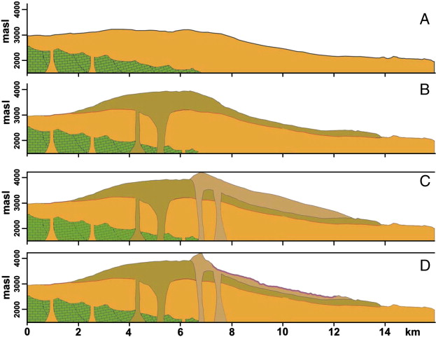
The Sierra Madre Occidental (SMO) is the largest continuous ignimbrite province in the world. It covers the NW portion of Mexico and has a minimum estimated volcanic rock volume of about 400,000 km3. The southern part of the North American Basin and Range extensional province is in Mexico and was formed by NW- to NE-trending normal faults that bound many large grabens, which are particularly long and deep in the southern SMO. Graben formation and ignimbrite-forming pyroclastic flow eruptions coincided in space and time, particularly for the 38¢23 Ma period, which has been referred to as the Ignimbrite Flare-up event. Geologic observations in the southern SMO indicate that the vents of several large-volume silicic ignimbrites were related to the graben master faults. We propose the new name ōgraben calderaö for this type of explosive-volcano-tectonic-collapse structure. The evidences for vent location of graben calderas include large pyroclastic dikes, co-ignimbrite lithic-lag breccias, and post-ignimbrite aligned rhyolitic domes and rhyolitic lava dikes. All these features are found along the graben caldera walls or on the graben''s margins and thus were controlled by the main graben faults. Large-volume ignimbrite-forming eruptions occurred during graben collapse, usually through several vents along the graben caldera walls. Often, only part of the graben acted as a collapse caldera. In most cases, the downdropped blocks inside the collapsed segment of the graben have several distinct tilting directions, opposite to those caused by regular domino faulting (with tilting outwards from the graben''s axis), indicating a chaotic collapse of blocks. This is interpreted as collapse of blocks during magma evacuation from an elongated and possibly batholith-sized magma chamber controlled by the regional extensional tectonics that existed under the collapsed segment of the graben. This collapse produced a piece-meal-like caldera confined within a graben. Generally, the pyroclastic dikes occur as discontinuous elongate lenses rather than regular tabular bodies. Usually, an elongated lava dome filled the vent and this totally covers the pre-existent pyroclastic dike, but in some cases the pyroclastic dike is exposed. Faulting and subsidence continued for several millions of years after the collapse and ignimbrite emplacement, displacing the intra-graben caldera products downward into the tectonic depression, but preserving or even intensifying the chaotic arrangement of the collapsed blocks. Fluvio-lacustrine continental deposits are generally found beneath and over the main and most voluminous ignimbrite, indicating that subsidence started before ignimbrite emplacement and graben collapse, and that continued after these events. In many cases the graben caldera vents are related to gold and silver hydrothermal mineralisation; thus understanding the relationship between ignimbrites, graben caldera vents, and fluvio-lacustrine deposits will be important for economic purposes.
C http://specialpapers.gsapubs.org/content/422/1.abstract - Magmatism and tectonics of the Sierra Madre Occidental and its relation with the evolution of the western margin of North America
The Sierra Madre Occidental is the result of Cretaceous-Cenozoic magmatic and tectonic episodes related to the subduction of the Farallon plate beneath North America and to the opening of the Gulf of California. The stratigraphy of the Sierra Madre Occidental consists of five main igneous complexes: (1) Late Cretaceous to Paleocene plutonic and volcanic rocks; (2) Eocene andesites and lesser rhyolites, traditionally grouped into the so-called Lower Volcanic Complex; (3) silicic ignimbrites mainly emplaced during two pulses in the Oligocene (ca. 32¢28 Ma) and Early Miocene (ca. 24¢20 Ma), and grouped into the ōUpper Volcanic Supergroupö; (4) transitional basaltic-andesitic lavas that erupted toward the end of, and after, each ignimbrite pulse, which have been correlated with the Southern Cordillera Basaltic Andesite Province of the southwestern United States; and (5) postsubduction volcanism consisting of alkaline basalts and ignimbrites emplaced in the Late Miocene, Pliocene, and Pleistocene, directly related to the separation of Baja California from the Mexican mainland. The products of all these magmatic episodes, partially overlapping in space and time, cover a poorly exposed, heterogeneous basement with Precambrian to Paleozoic ages in the northern part (Sonora and Chihuahua) and Mesozoic ages beneath the rest of the Sierra Madre Occidental.
The oldest intrusive rocks of the Lower Volcanic Complex (ca. 101 to ca. 89 Ma) in Sinaloa, and Maastrichtian volcanics of the Lower Volcanic Complex in central Chihuahua, were affected by moderate contractile deformation during the Laramide orogeny. In the final stages of this deformation cycle, during the Paleocene and Early Eocene, ∼E-W to ENE-WSW¢trending extensional structures formed within the Lower Volcanic Complex, along which the world-class porphyry copper deposits of the Sierra Madre Occidental were emplaced. Extensional tectonics began as early as the Oligocene along the entire eastern half of the Sierra Madre Occidental, forming grabens bounded by high-angle normal faults, which have traditionally been referred to as the southern (or Mexican) Basin and Range Province. In the Early to Middle Miocene, extension migrated westward. In northern Sonora, the deformation was sufficiently intense to exhume lower crustal rocks, whereas in the rest of the Sierra Madre Occidental, crustal extension did not exceed 20%. By the Late Miocene, extension became focused in the westernmost part of the Sierra Madre Occidental, adjacent to the Gulf of California, where NNW-striking normal fault systems produced both ENE and WSW tilt domains separated by transverse accommodation zones. It is worth noting that most of the extension occurred when subduction of the Farallon plate was still active off Baja California.
Geochemical data show that the Sierra Madre Occidental rocks form a typical calcalkaline rhyolite suite with intermediate to high K and relatively low Fe contents. Late Eocene to Miocene volcanism is clearly bimodal, but silicic compositions are volumetrically dominant. Initial 87Sr/86Sr ratios mostly range between 0.7041 and 0.7070, and initial ϵNd values are generally intermediate between crust and mantle values (+2.3 and -3.2). Based on isotopic data of volcanic rocks and crustal xenoliths from a few sites in the Sierra Madre Occidental, contrasting models for the genesis of the silicic volcanism have been proposed. A considerable body of work led by Ken Cameron and others considered the mid-Tertiary Sierra Madre Occidental silicic magmas to have formed by fractional crystallization of mantle-derived mafic magmas with little (<15%) or no crustal involvement. In contrast, other workers have suggested the rhyolites, taken to the extreme case, could be entirely the result of partial melting of the crust in response to thermal and material input from basaltic underplating. Several lines of evidence suggest that Sierra Madre Occidental ignimbrite petrogenesis involved large-scale mixing and assimilation-fractional crystallization processes of crustal and mantle-derived melts.
Geophysical data indicate that the crust in the unextended core of the northern Sierra Madre Occidental is ∼55 km thick, but thins to ∼40 km to the east. The anomalous thickness in the core of the Sierra Madre Occidental suggests that the lower crust was largely intruded by mafic magmas. In the westernmost Sierra Madre Occidental adjacent to the Gulf of California, crustal thickness is ∼25 km, implying over 100% of extension. However, structures at the surface indicate no more than ∼50% extension. The upper mantle beneath the Sierra Madre Occidental is characterized by a low-velocity anomaly, typical of the asthenosphere, which also occurs beneath the Basin and Range Province of the western United States.
The review of the magmatic and tectonic history presented in this work suggests that the Sierra Madre Occidental has been strongly influenced by the Cretaceous-Cenozoic evolution of the western North America subduction system. In particular, the Oligo-Miocene Sierra Madre Occidental is viewed as a silicic large igneous province formed as the precursor to the opening of the Gulf of California during and immediately following the final stages of the subduction of the Farallon plate. The mechanism responsible for the generation of the ignimbrite pulses seems related to the removal of the Farallon plate from the base of the North American plate after the end of the Laramide orogeny. The rapid increase in the subduction angle due to slab roll-back and, possibly, the detachment of the deeper part of the subducted slab as younger and buoyant oceanic lithosphere arrived at the paleotrench, resulted in extension of the continental margin, eventually leading to direct interaction between the Pacific and North American plates.
The Sierra Nevada Volcanic Range includes, from south to north, the active Popocatepetl (5452 m), Iztaccihuatl (5272 m) with several volcanic edifices, Telapon (4000 m), and Tlaloc (4150 m) volcanoes. It has been generally assumed that volcanic activity has migrated from Tlaloc (north) to Popocatepetl (south) over time. New evidence obtained from previous studies, field reconnaissance, and radiometric dating indicate that magmatism at the Sierra Nevada Volcanic Range likely started at 1.8¢1.4 Ma with the construction of Paleo-Tlaloc volcano, which is today buried by younger deposits. The activity continued between 1.07 and 0.89 Ma with the emplacement of dacitic domes (Puico, Yahualica, Yeloxochitl, Tearco, and Torrecillas), lavas and associated pyroclastic flows as the San Francisco (1 Ma), and Chicoloapan (0.9 Ma). Afterwards, the main edifice of modern Tlaloc was built up through the emission of dacitic lava flows (0.94¢0.84 Ma). Iztaccнhuatl began its activity ca. 1.1 Ma with the formation of several volcanic edifices up to 0.45 Ma, time during which a Mount St. Helens¢type event destroyed the southeastern flank of Los Pies Recientes cone, producing a debris avalanche and pyroclastic deposits. Telapon volcano formed approximately between 0.38 Ma and 0.34 Ma ago with the emplacement of lava flows and a dome that become quiescent afterwards. Apparently, ca. 0.32 Ma, Popocatepetl began its eruptive activity that continues today. Strikingly, Tlaloc reawakened with the emission of rhyolitic magma at 0.129 Ma followed by the emplacement of the El Papayo dacite (118 ka) to the south and Tйyotl summit lavas (80 ka). Activity continued at Tlaloc with the generation of five explosive eruptions at 44, 38, 33, 31, and 25 ka and the growth of the summit dome. Coevally, Popocatepetl, at the southern end of the range, had collapsed twice to the south and had intense volcanic activity up until today. Holocene activity has taken place at Iztaccнhuatl with the 9 ka Buenavista dacitic lava flow and repetitive Plinian eruptions of Popocatйpetl including some historic events and the 1994¢present eruption. Popocatйpetl''s reawakening reminded authorities, scientists, media, and the public of its potential risk. In fact, on 22 January 2001, the rapid collapse of an eruptive column generated scoria-rich pyroclastic flows that partly melted the glacier producing lahars. From the above considerations it is obvious that magmatism of the Sierra Nevada Volcanic Range did not keep a continuous north to south migrating path, but it rather shifted back and forth chaotically throughout its evolution. It is worth mentioning that major gaps presented in the eruptive sequence are most likely due to poor radiometric coverage of the area that may improve in the future. http://fieldguides.gsapubs.org/content/25/163.abstract
Los Atlixcos, 800m
Ceboruco, 2280m, 1875
Cerro Prieto, 223m, Holocene
Chichinautzin, 3930 m
El Chichon, 1060 m, 1982
Comondu-La Purisima, 780m
Coronado, 440m,
Cuexcomate, 13m
Las Cumbres, 3940m, 3940BC
Las Derrumbadas, 1500m,
Durango Volcanic Field, 2075m
La Gloria Volcanic Field, 3600m
Guadalupe, 1100m
Los Humeros, 3150m, Holocene
Jaraguay Volcanic Field, 960m, Holocene
Jocotitlan, 3900m, 1270+/-75 years
Jorullo, 3170m, 1774
Mascota Volcanic Field, 2540m, Holocene
Michoacan-Guanajuato, 3860m, 1952
Naolinco Volcanic Field, 2000m, Holocene
Nevado de Toluca, 4690m, 1350BC
Papayo, 3600, Holocene
Paricutin, 2800m, 1952
Pinacate Peaks, 1200m,
San Borja Volcanic Field, 1360m, Holocene
San Martin Tuxtla, 1650m, 1796
San Quintin Volcanic Field, 260m, Holocene
Sanganguey, 2353m, 1742
Serdan-Oriental, 3485m, Holocene
Tilzapotla
Zitacuaro-Valle de Bravo, 3500 m
MexicoÆs Other Volcanoes
Volcanism of Mexico
Mexico Volcanoes and Volcanics
Paricutin
Geology south of Trans-Mexican Volcanic Belt TMVB