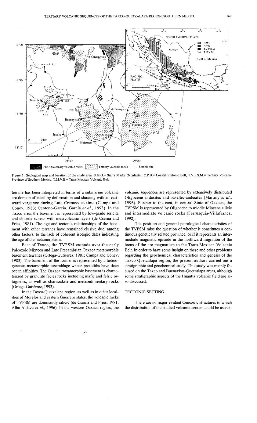
 | TILZAPOTLA-BUENAVISTA CALDERA AND Zapalco–Amacuzac area |
Volcanic-Plutonic Connection in the Tilzapotla Caldera Ignimbrites in Southern Mexico . Age and compositional similarities in broad exposures of volcanic and plutonic rocks in the central sector of the late Eocene-early Oligocene silicic volcanic province in southern Mexico provide an excellent opportunity for studying the genetic connection between the volcanic and plutonic realms. The Taxco-Tilzapotla sector is of particular interest given the presence of a NW-SE oriented elliptical dome structure (50 x 35 km) that encloses the Tilzapotla caldera, three medium-grained plutons one of which contains mafic magmatic enclaves, hypabyssal intrusive bodies, rhyolitic domes, and voluminous ignimbrites. North-south trending Laramide folds in Cretaceous marine sedimentary rocks were disrupted when late Eocene magmas intruded into the upper crust, forming the dome and producing opposite plunges in pre-dome fold axes north and south of the elliptical structure. We have obtained LA-ICPMS zircon U-Pb and Ar-Ar mineral ages as well as electron microscope analyses of different magmatic facies in order to: better understand the chronology of magmatic evolution in the area; examine the possible genetic relationship between the plutonic rocks and the principal ignimbritic units, in particular the crystal-rich units; and determine possible compositional differences that might suggest the injection of different batches of magma. U-Pb crystallization ages of 37-36 Ma were determined on zircons from different facies of the Coxcatlan granodiorite. Slightly younger zircon U-Pb crystallization ages were obtained for ignimbrites from the Tilzapotla caldera (36-35 Ma) and for the more mafic Chiautle pluton (34.6 Ma) that is exposed near the southern boundary of the dome structure. Earlier work by our group established caldera collapse and extrusion of the Tilzapotla ignimbrite at 34.3 Ma. Ar-Ar dating gives cooling ages of 33 Ma in sanidine for an intracaldera ignimbrite and some late stage silicic and intermediate magmas yielded mainly between 33-32 Ma. The new and previous age data suggest that the development of the elliptical dome structure is related to the gradual construction of a batholith at depth in the Taxco-Tilzapotla sector with the emplacement of different magma batches over approximately five million years, and that the Tilzapolta caldera, in the southeasternmost part of the dome structure, represents an episode characterized by a high rate of magma input. Caldera collapse might have been triggered by injection of mafic components identified in the southeastern part of the dome. Microprobe chemical analyses of biotite and plagioclase from the Coxcatlan pluton and Tilzapotla ignimbrite show compositional differences between the intrusive and extrusive rocks, confirming the intrusion of different batches of magma that gradually constructed the batholith. http://adsabs.harvard.edu/abs/2011AGUFM.V21C2511M |
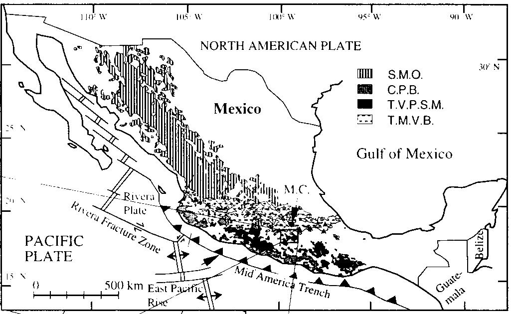
THE TILZAPOTLA-BUENAVISTA CALDERA: A TECTONO-MAGMAGMATIC FEATURE ASSOCIATED WITH EOCENE-OLIGOCENE STRIKE-SLIP TECTONICS IN SOUTHERN MEXICO The Tilzapotla ignimbrites are part of a Tertiary volcanic province located south of the Miocene to Quaternary Trans-Mexican Volcanic Belt. These rocks, together with the coastal plutonic belt of southern Mexico have been associated with the convergence process previous and during the displacement of the Chortis Block. The Eocene-Oligocene silicic volcanic rocks in the Tilzapotla -Buenavista area are associated with a large scale (30 x 20 km) oval-shaped structure, the main features of which indicate a volcanic collapse caldera. The outflow volcanic units are poorly preserved because of the deep erosion, but the distribution and thickness of some outflow ignimbrite remnants as well as the exposed fill thickness suggest a minimum volume of 500 m3. The intracaldera fill is composed of at least three major ignimbrite units as well as slide breccias that include, at the southeastern margin, megablocks embedded in the lower ignimbrite. K-Ar ages of the volcanic sequence range from 35 to 31 Ma. Resurgence is indicated by the central doming inferred from the differences in the altitude between outflow and fill tops as well as the occurrence of lava domes and associated subvolcanic rocks. Thickness variations and the general geometry of the caldera indicate a trap-door-like configuration. The southwestern margin of the caldera, which constitutes one of the long sides of the oval structure, is collinear with a regional fault that in neighboring areas displays left-lateral kinematic indicators. Given the position of the Tilzapotla caldera on the northwest side of this lineament near its southeastern end, we interpret that magma ascent and the later collapse of the caldera was favored by extension associated with the termination of a left lateral fault segment. https://gsa.confex.com/gsa/2002CD/finalprogram/abstract_34581.htm |
(A) Sketch map of the central part of the northern Sierra Madre del Sur showing the distribution of Tertiary volcanic rocks and the main Cenozoic tectonic features in the region. (B) Distribution of the ignimbritic rocks attributed in this study to the Tilzapotla caldera, including the distribution of the outflow sheet remnants of the Tilzapotla ignimbrite. The Tilzapotla caldera constitutes the first discovery of a major Tertiary collapse volcanic structure south of the Mexican Volcanic Belt. Although it is spatially associated with silicic ignimbrites in a region relatively distant from the extensive ignimbritic province of the Sierra Madre Occidental (SMO), it is among the largest collapse calderas documented in Mexico. The caldera is defined by a 33x24 km semi-elliptical structure that encircles the largest exposures of the Tilzapotla ignimbrite and corresponds to the structural margin rather than the topographic rim. A central uplifted block limited by NW-trending faults is the main indication of a resurgent stage. The caldera structural margin is surrounded by extensive exposures of Cretaceous marine sequences that structurally define a broad elliptical dome (45x35 km) originated in the first stage of the caldera evolution. There is evidence showing that the 34 Ma Tilzapotla ignimbrite represents the climatic event of the caldera collapse. It is constituted by a massive sequence of crystal vitric tuff with conspicuous euhedral biotite and abundant quartz. The intra-caldera facies is intercalated with mega- and meso-breccias of limestone and anhydrite fragments derived from the slumping of the caldera wall during the caldera collapse. The overlying sequence includes post-collapse ignimbrites as well as amphibole and pyroxene bearing dacitic to andesitic lava flows. The age (33 to 32 Ma) and isotopic signatures of these lava flows indicate a resurgent event related with the input of more primitive magmas into the magma chamber. The rectilinear northeastern and southwestern segments of the structural margin of the caldera correspond to NW-trending tectonic lineaments that are part of a regional strike-slip system, active at the time of the caldera formation. We interpret that the NW tectonic structures defined zones of weakness that accommodated the caldera collapse in the northeastern and southwestern segments of the caldera structural margin. http://www.sciencedirect.com/science/article/pii/S0377027304001660 |
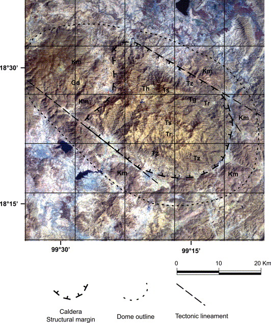
Landsat Thematic Mapper (TM) image of the Tilzapotla caldera area. Tz=Tilzapotla ignimbrite, Tr=Rodarte ignimbrite, Tg=Gallego ignimbrite, Ts=El Salto lava flows, Th=hypabyssal rocks, Gd=Coxcatlбn granodiorite intrusion, Km=marine Cretaceous rocks. The caldera structural margin and main tectonic lineaments are indicated. The area where the elliptical dome is recognizable is encircled by a finer dashed line. Satellite image is provided by Industrias Penoles Mining Company |
Geologic map of the Tilzapotla caldera area. Distribution of Mesozoic units was based on the geologic map published by Consejo de Recursos Minerales (Rivera-Carranza et al., 1998). Sections A–B and C–D presented in Fig. 5 are indicated as solid lines |
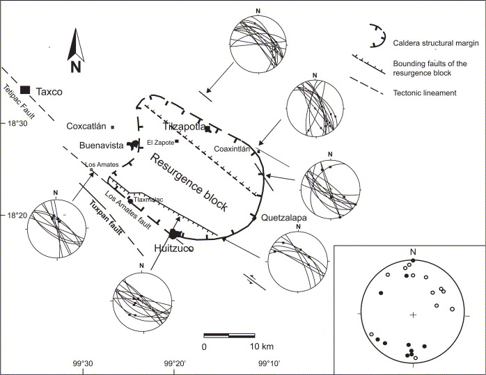
Structural sketch map showing the caldera margin, the resurgence block and the related tectonic lineaments. Solid lines indicate those segments with direct evidence of the position of the structural margin. Fault data and striations from selected localities are shown in equal area nets, lower hemisphere. Plunges that portray the structural interference between the dome structure and the Laramide folds are shown in the inset. Solid and open circles indicate plunges measured in marine beds distributed south and north of the caldera, respectively |
Fig. 5. Schematic N–S and E–W trending sections through the Tilzapotla caldera. Vertical scale is exaggerated to enhance resurgence features. The ring fault projection is shown vertical for convenience. Note changes in altitude of Tilzapotla and Rodarte ignimbrites produced by the uplift of the central block |
Generalized composite stratigraphic sections of the central eastern and the western zones of the Tilzapotla caldera, as well as the extra-caldera section observed south of Valle de Vбzquez. Since the thickness of volcanic units is variable, those indicated are only representative |
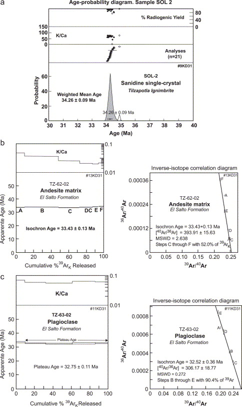
Graphic representations of Ar–Ar data obtained from samples: (a) Sol 2 of the Tilzapotla ignimbrite; (b) Tz 62-02 and (c) Tz 63-02 of the El Salto lava flows. The Sol 2 age was obtained from the total fusion of 21 single crystals of sanidine |
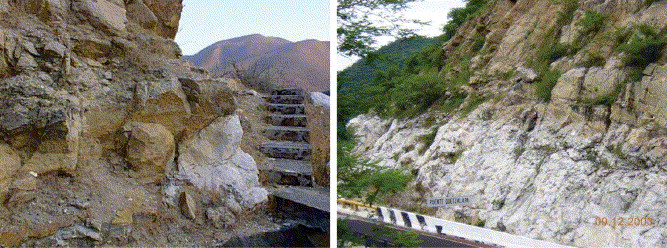
Blocks of limestone embedded in the Tilzapotla ignimbrite of the mega-breccia interval from localities at the southeastern segment of the ring fault |
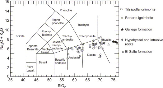
TAS diagram showing the composition of representative samples of different volcanic units of the Tilzapotla caldera -http://www.sciencedirect.com/science/article/pii/S0377027304001660 |
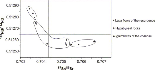
87Sr/86Sri–143Nd/144Ndi diagram showing initial isotopic ratios of representative samples of volcanic rocks of the Tilzapotla caldera. Initial ratios were calculated for t=34 Ma. Analyses were carried out in the Laboratorio Universitario de Geoquı́mica Isotopica (LUGIS), UNAM -http://www.sciencedirect.com/science/article/pii/S0377027304001660 |
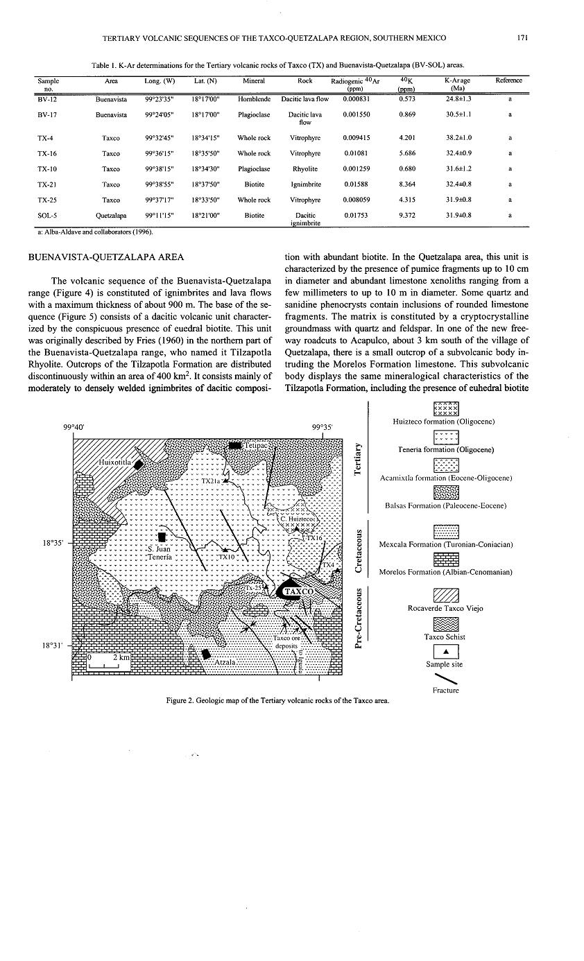
Tilzapotla Formation, are suggestive of resurgent activity after the caldera fonnation http://satori.geociencias.unam.mx/15-2/(7)Moran.pdf |
Tilzapotla Formation, are suggestive of resurgent activity after the caldera fonnation http://satori.geociencias.unam.mx/15-2/(7)Moran.pdf |
|
|
|
|
|
|
|
|
|
|
THE TILZAPOTLA-BUENAVISTA CALDERA: A TECTONO-MAGMAGMATIC FEATURE ASSOCIATED WITH EOCENE-OLIGOCENE STRIKE-SLIP TECTONICS IN SOUTHERN MEXICO .The Tilzapotla ignimbrites are part of a Tertiary volcanic province located south of the Miocene to Quaternary Trans-Mexican Volcanic Belt. These rocks, together with the coastal plutonic belt of southern Mexico have been associated with the convergence process previous and during the displacement of the Chortis Block. The Eocene-Oligocene silicic volcanic rocks in the Tilzapotla -Buenavista area are associated with a large scale (30 x 20 km) oval-shaped structure, the main features of which indicate a volcanic collapse caldera. The outflow volcanic units are poorly preserved because of the deep erosion, but the distribution and thickness of some outflow ignimbrite remnants as well as the exposed fill thickness suggest a minimum volume of 500 m3. The intracaldera fill is composed of at least three major ignimbrite units as well as slide breccias that include, at the southeastern margin, megablocks embedded in the lower ignimbrite. K-Ar ages of the volcanic sequence range from 35 to 31 Ma. Resurgence is indicated by the central doming inferred from the differences in the altitude between outflow and fill tops as well as the occurrence of lava domes and associated subvolcanic rocks. Thickness variations and the general geometry of the caldera indicate a trap-door-like configuration. The southwestern margin of the caldera, which constitutes one of the long sides of the oval structure, is collinear with a regional fault that in neighboring areas displays left-lateral kinematic indicators. Given the position of the Tilzapotla caldera on the northwest side of this lineament near its southeastern end, we interpret that magma ascent and the later collapse of the caldera was favored by extension associated with the termination of a left lateral fault segment. MORAN-ZENTENO, Dante J., ALBA-ALDAVE, Leticia A., SOLE-VIСAS, Jesъs, and GONZБLEZ-TORRES, Enrique A., Instituto de Geologнa, Universidad Nacional Autуnoma de Mйxico, Ciudad Universitaria, Mйxico D.F, 04510, Mexico, dante@geologia.unam.mx https://gsa.confex.com/gsa/2002CD/finalprogram/abstract_34581.htm Tilzapotla Formation, are suggestive of resurgent activity after the caldera fonnation http://satori.geociencias.unam.mx/15-2/(7)Moran.pdf |
|
|
|
|
|
|
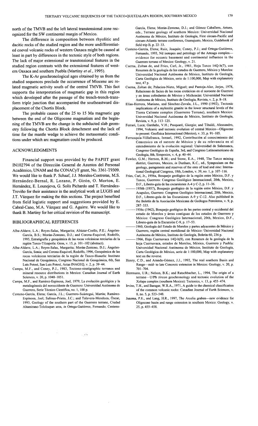
The Zapalco–Amacuzac area in the Morelos and Guerrero states, southern Mexico, constitutes one of the classic sectors where Paleogene continental beds of the Balsas Group were originally described. The exposed succession has an apparent thickness of 2,500 m and it is constituted by two distinct sedimentary units separated by a slightly angular unconformity and by two intercalated ignimbrites (35.1 and 38.5 Ma, sanidine, K–Ar). The basal beds of the lower sedimentary unit (Tepetlapa Formation) are constituted by matrix–supported conglomerates that grade upwards to sandstone –with a poorly defined planar parallel stratification and some intercalated andesitic and mafic lava flows. One of the andesites yielded a whole rock K–Ar date of 44.5 Ma. Intercalations of conglomerate beds increase again toward the top of this unit. The upper sedimentary unit (Huajintlan Formation) is constituted by a ~300 m thick succession of matrix–supported conglomerate with some lenses of conglomeratic sandstone. This unit unconformably underlies the Tilzapotla ignimbrite whose best age estimate is 34.3 Ma (sanidine Ar–Ar). The beds of the two sedimentary formations dip east to northeast with higher dips for the lower unit (50–30°). Recognized facies in both units are indicative of an alluvial fan environment with more proximal facies for the Huajintlan Formation. The studied succession is located immediately northwest of a large elliptical (50x30 km) dome structure that resulted from the tumescence stage, in the early evolution of the Tilzapotla caldera, previous to the collapse. The northwestern termination of the dome merges and interferes with the NNE–trending Laramide fold and thrust front of the Iguala Cacahuamilpa highs, near Taxco. In the study area, the dome contours display a local inflection defined by a change in the dip direction of the Morelos and basal beds of the Tepetlapa Formation from north to east. The slight angular unconformity between the Tepetlapa Formation and the overlaying units indicates a first stage of eastward tilting related to an uplift episode in the Taxco area, probably originated by the emplacement of silicic magmas (ca. 38 Ma). The proximal facies of the overlaying Huajintlan Formation and the age (35.1 Ma) of the Piedras Altas Tuff , indicate that this formation resulted from the rejuvenation of the source area triggered by the tumescence and the initiation of the volcanic activity in the nearby Tilzapotla caldera area. This is confirmed by the higher dips ( 50°) of the Tepetlapa Formation near the dome structure and the decreasing dips toward the northeast. The age of one andesite lava flow (44.5 Ma) intercalated in the lower unit is indicative of an Eocene age for the beginning of the Balsas Group accumulation in this area. Key words: terrestrial sedimentation, Southern Mexico, Balsas Group, Tilzapotla caldera, Eocene. |
The Balsas Group was originally described by Fries (1960) as a succession of terrestrial deposits made up of conglomerate, sandstone, siltstone and lacustrine limestone as well as pyroclastic and lava flows. Fries (1960) included within the Balsas Group successions that crop out in five different areas distributed within the Morelos and northern Guerrero states. Subsequently, de Cserna and Fries (1981) and de Cserna (1982) applied the name of Balsas Formation to successions equivalent to the Balsas Group distributed in northwestern Guerrero State, southern Estado de Mexico and western Michoacan State. However, in neither case was this unit formally defined. In general, the main criterion used to allocate terrestrial rocks as part of the Balsas Group in central Guerrero and Morelos states has been its stratigraphic position. All conglomeratic units thatunconformably overlie deformed Cretaceous marine beds and underlie Eocene–Early Oligocene volcanic rocks (i.e., "Tilzapotla Rhyolite" in its broad sense) (Fries, 1960) have been considered part of the Balsas Group. Therefore, a diverse range of Tertiary terrestrial continental sedimentary successions widespread from western Michoacбn State to western Guerrero State have been described as part of the Balsas Group (i.e., Fries, 1960; 1966; de Cserna and Fries, 1981, de Cserna, 1982). Given the scarcity of paleontological and geochronological data, inferences on the age range and regional chronological variations of the Balsas Group are still vague. However, in a few localities, more precise inferences based on geochronological data have been made. For example, near Tetelcingo (Figure 1), by the Balsas river, Ortega–Gutiйrrez (1980) and Cerca et al. (in press) reported intermediate and silicic volcanic rocks, with K–Ar and Ar–Ar dates ranging from 60 to 68 Ma, that underlie terrestrial rocks assigned to the Balsas Group. Cerca et al. (in press) provided geochronological data and stratigraphic observations that indicate that the lower beds of the Balsas Group are intercalated with Paleocene volcanic rocks. These authors also reported and compiled geochronologic data from late Eocene–early Oligocene volcanic rocks that overlie the Balsas Group in a broad area around the high Balsas river. Molina–Garza and Ortega–Rivera (2006) obtained an Ar–Ar age of 33.1 Ma for an ignimbrite intercalated in a succession attributed to the Balsas Group, southeast from the Tilzapotla caldera, between Tuzantlбn and the Balsas river. Based on a magnetostratigraphic analysis, the authors suggested that the whole succession belongs to the Eocene. In the Taxco area, Alaniz–Alvarez et al. (2002) recognized different sedimentary units (previously included within the Balsas Group by Fries), separated by andesites and ignimbrites ranging in age from 33 to 38 Ma. These authors also described a "red conglomerate" previously mentioned by Edwards (1955) and Fries (1960) in the Acamixtla–Taxco sector. The succession of reddish conglomerate underlies the earliest late Eocene volcanic rocks in the area and do not display any folding effects. De Cserna (1983) suggested that parts of the Balsas Group in southern Estado de Mйxico and westernmost Michoacбn may be Late Cretaceous in age. This is coincident with inferences by Campa and Ramнrez (1979) who interpreted continental beds as Late Cretaceous in age (Cutzamala Formation), based on the occurrence of marine limestone intercalations and the folding deformation. More recently, Benammi et al. (2005) reported in the Tiquicheo region, eastern Michoacбn, the finding of dinosaur rests, confirming that continental deposits resembling those of the Balsas Group in this region are, at least partially, Late Cretaceous in age.Available up–to–date data suggest that not all the terrestrial successions that were deposited previously to the widespread late Eocene to early Oligocene volcanism belong to the Balsas Group in the original meaning given by Fries (1960). Therefore more detailed stratigraphic and geochronologic studies are required to differentiate the units that have been wrongfully considered as one single depositional event, under the name of Balsas Group. There are also different interpretations on the origin of the basin–fills that have been grouped under the Balsas Group. According to Cerca et al. (in press), Balsas Group rocks in the Balsas river region accumulated in intermontane basins originated as a consequence of the Late Cretaceous Laramide deformation. In contrast, Alaniz–Alvarez et al. (2002) interpreted that Balsas Group units (Chontalcuatlбn and Atzala formations) in the Taxco area and to the north were accumulated in a pull–apart basin associated with NW and N–trending strike–slip faults. Preliminary evidence indicates that several independent sedimentary basins in Guerrero and Morelos states, with similar depositional environments, developed at different times, but all were covered by late Eocene–early Oligocene volcanic rocks (Cerca et al., in press). Beyond the problem of applying the same lithostrati–graphic denomination to a diversity of terrestrial deposits distributed in several basins, there are uncertainties regarding the age range, sedimentary environment and tectonic conditions during their accumulation. In order to set some constraints on the stratigraphy, depositional environments and age of what is described as the Balsas Group by Fries (1960), we have undertaken detailed studies in some selected areas of Morelos and northern Guerrero States. In this paper we present the results of a stratigraphic and geochronological study of the Amacuzac– Zacapalco area, which is located southwest of Cuernavaca city, and is traversed by the highway and roads to Taxco and Iguala (Figure 2). The Amacuzac–Zacapalco area contains extensive exposures of the Balsas Group rocks that allowed us to carry out detailed field observations |
The angular unconformity separating the basal Tepetlapa beds and the underlying folded beds of Mezcala and Morelos formations (Figure 4b) indicate a time interval between the cessation of the Laramide deformation and the accumulation of the terrestrial deposits. The alluvial fan that originated the Tepetlapa Formation probably originated from an outlet of the topographic front formed by the thrust anticline. This is also suggested by the general eastward decrease in the clast size of the Tepetlapa Formation. The location and origin of the eastern limit of the sedimentary basin is unknown because it is covered by Pliocene epiclastic and alluvial deposits that unconformably overlie the Balsas Group and the Mezcala Formation. The sedimentary facies recognized in the Tepetlapa Formation are indicative of an alluvial fan environment dominated by debris flow and sheet flow deposits. The lower and middle members show distal fan and/or flood plain facies (Figure 7a). The upper member shows a coarsening–upward tendency, which might be related to the rejuvenation of the landscape. This probably was due to a first uplift stage related to the emplacement of silicic magmas in the Taxco volcanic center located at the northwestern side of the Tilzapotla dome structure. This is also suggested by an increment in the percentage of volcanic clasts in onglomerate beds of the same upper member. The slight angular unconformity between the Tepetlapa formation and the overlaying units records a break in the sedimentation and is probably related to the eastward tilting produced by this uplift episode. Regional geocronology of silicic magmatism suggest that the doming process began near the Taxco volcanic center at around 38 Ma and was progressing toward the SE until 34 Ma, when the collapse of the Tilzapotla caldera occurred. There is no evidence of normal or lateral faulting at the piedmont that could have produced a slope break between the accumulation area and highlands to the west. Therefore we suggest that the deposition of the Tepetlapa Formation occurred at the flank of an intermontane basin. The age range of the Tepetlapa Formation is less well constrained than the ages of the overlying units. The age obtained for an andesitic flow comes from the upper member (44.5 ± 0.7 Ma), and indicates a minimum Eocene (Lutetian) age for the sedimentation. Therefore the Tepetlapa Formation was not related to the evolution of the Tilzapotla caldera, but to a previous stage in the evolution of the sedimentary basin. Remarkably coarser textures of the Huajintlбn Formation indicate a significant change in the depositional environments. The relatively high abundance of sandstone and siltstone lithic fragments in the Tepetlapa beds, resembling the lithology of the Upper Cretaceous Mezcala Formation, is not found in the Huaj intlбn Formation. In contrast, the Huaj intlбn Formation is dominated by limestone clasts derived from the Morelos Formation. This change in composition of the lithic components is indicative of a change in the dominant lithology exposed in the source area. In addition to the change in clast composition, there is a major change in the facies and depositional environments in the Huajintlбn Formation, compared to those observed in the Tepetlapa Formation. The coarse matrix–supported conglomerate texture and the sedimentary features of rocks of the Huajintlбn Formation are typical of proximal alluvial fan deposits (Figure 7d). The change in clast composition and depositional environments recorded in the Huajintlan Formation suggests an uplift of the source area, which occurred in a more proximal position to the studied area. The best candidate for the rejuvenation of the landscape and the change in the sedimentary system observed in the area is the late Eocene doming produced by magma emplacement in the early stages of the evolution of the Tilzapotla volcanic center (Figures 5 and 7d). This is supported by the age of the ignimbrites underlying (Piedras Altas) and overlying (Tilzapotla) the Huajintlan Formation. The best age estimate for the caldera collapse is the 34.29 Ma Ar–Ar date obtained for the Tilzapotla ignimbrite (Morбn–Zenteno et al., 2004) at the eastern margin of the caldera. These results, compared to the K–Ar date of 35.2 Ma of the Piedras Altas Ignimbrite, left a time interval of at least 0.5 Ma for the volcanic center evolution since the first pre–collapse ignimbrite emplacement, which is a reasonable time for this kind and size of volcanic center (Smith and Bailey, 1968). The northeastward and eastward relative high dip of the westernmost Tepetlapa beds at the dome border ( 50°) and their strike following the inflection in the contours of this structure indicate a tilting episode related to the tumescence in the Tilzapotla caldera (Figure 4a). The relatively slight angular relationship with the syn– and post– doming Huajintlan Formation farther to the northeast, indicates that the tilting effect produced by the tumescence decreased in a short distance from the dome boundary. The K–Ar ages obtained from intercalated volcanic rocks (35.2, 38.5 and 44 Ma) in the studied succession (Figure 3, Table 1) indicate that the main episodes of deposition occurred during the Eocene. The age estimates for the Balsas Group in the study area are in part similar to those obtained in other areas within the Guerrero–Morelos region. In the nearby Taxco area, Alaniz–Бlvarez et al. (2002) documented Eocene volcanic rocks intercalated with continental deposits, similar to those of the study area. There are no indications that the basal beds of the studied succession could be contemporary with the Paleocene beds exposed along the Balsas river in central Guerrero State (Cerca, 2004). Even assuming low rates of sedimentation for the beds underlying the oldest dated andesite (44 Ma) in the studied area, it could hardly be interpreted that the basal beds reach a Paleocene age, unless significant interruptions of sedimentation of the Tepetlapa Formation occurred, which is not evident in the studied sections. This indicates that the evolution of the Paleogene continental basins began diachronously in the region. There are no signs of accumulation in a coeval, fault–bounded, subsidence basin as it has been documented in the neighboring Taxco region. Inclination of Balsas beds in the area are clearly related to doming processes and no listric faults seem to have been involved in the tilting process. Besides the evidence of tilting related to the doming process in the Tilzapotla caldera area, the structural attitude does not support listric or lateral faulting associated with the main slop break, separating the accumulation area from the highlands to the west. There is no evidence of the prolongation in this area of the tectonic lineament that defines the northeastern boundary of the Tilzapotla caldera (Figures 2, 4a). Sedimentary and volcanic facies identified in this work suggest that five successive paleoenvironmental settings characterized the sedimentation of the Balsas Group throughout time in the Amacuzac region (Figure 7a–e): 1) distal alluvial fan or flood–plain sedimentation of the lower and middle member of the Tepetlapa Formation; 2) progradation of the fan lobe at the time of the andesitic volcanism, recorded in the upper member of the Tepetlapa Formation; 3) tilting of the Tepetlapa Formation related to the first stage of uplift originated by doming near the Taxco area and emplacement of the Teacalco Tuff; 4) initial stages of volcanic activity in the Tilzapotla volcanic center (Piedras Altas Tuff) and development of a new fan lobe (Huajintlбn Formation), originated by the pre–caldera tumescence; 5) post–Balsas volcanism related to the caldera formation (Tilzapotla ignimbrite) and later initiation of intermediate magmatism (Zacapalco Andesite). Regarding the concept of using the name Balsas Group, it should be considered that this name was proposed but not formally defined as a lithostratigraphic unit by Fries (1960). In addition, the name has been used for relatively diverse deposits accumulated in different basins and with different lithostratigraphic rank (i.e., Balsas Formation, de Cserna, 1982). We think that, in order to avoid further confusions, it should remain as an informal group, as originally described by Fries, until lateral relationships among sedimentary units distributed in these basins can be documented in more detail. http://scielo.unam.mx/scielo.php?script=sci_arttext&pid=S1026-87742007000100006&lng=en&nrm=iso |


STRATIGRAPHY
The Balsas Group in the Amacuzac–Zacapalco area unconformably overlies deformed beds of the Morelos and Mezcala formations. The Morelos Formation consists of over 1,000 m of platform limestone successions, while the Mezcala Formation is constituted by alternated marine beds of sandstone, siltstone and shale. The Balsas Group is made up of conglomerate, sandstone and siltstone, including intercalations of silicic ignimbrites and andesitic lava flows (Fries 1960, Monter–Ramirez, 2004). On the basis of differences in the dominant lithologies and the occurrence of a minor angular unconformity, the Balsas Group is divided in this study into two sedimentary and two pyroclastic units. The basal unit, defined here as the Tepetlapa Formation, is dominated by sandstone beds with subordinated intercalations of siltstone and matrix–supported conglomerate. The Tepetlapa Formation is unconformably overlain by the two pyroclastic units, which from base to top are the Teacalco Tuff and the Piedras Altas Tuff. To the south, these volcanic units pinch out entirely and leave in direct contact the Tepetlapa and Huajintlбn formations. The uppermost unit, also sedimentary, is named here as the Huajintlбn Formation. This formation is made up of coarse matrix–supported conglomerate, unconformably covered by the late Eocene (34 Ma) Tilzapotla ignimbrite (Moran–Zenteno et al., 2004). These units are also unconformably covered by post Eocene andesite flows (Zacapalco Andesite) and by Pliocene volcanic debris–flow deposits (Cuernavaca Formation) (Figures 3, 4a, 4b) (Fries, 1960; Moran Zenteno et al., 2004).
Tepetlapa Formation
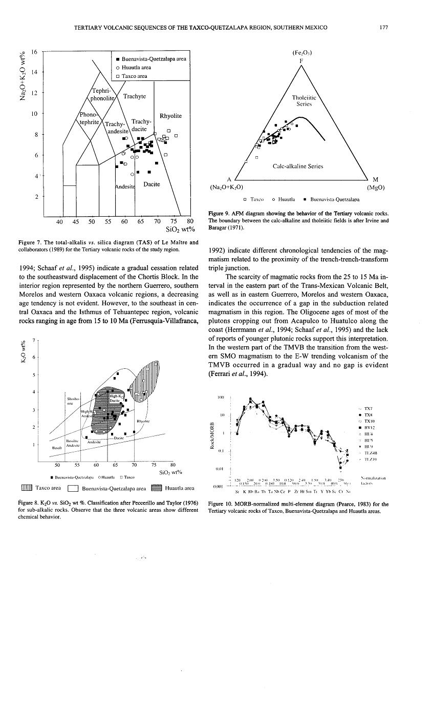
The Tepetlapa Formation is here defined as a succession of intercalated siltstone, sandstone and matrix–supported conglomerate with an apparent thickness of 2000 m. It shows lateral and vertical variations in grain size as well as in bed thickness. The best exposures of the Tepetlapa Formation are located along highway 90, near Santa Fe de Tepetlapa village (Km. 19–22, from 99° 24''''30" to 99°46''''00" longitude) (Figure 4a), forming a succession that we consider here as the type section. The contact with the underlying Mezcala and Morelos formations is an angular unconformity, but it was locally overprinted by NW trending left lateral faults, which can be observed in outcrops at the highway cuts near Zacapalco.
The succession was divided into three members (Figure 3). The basal member is 150 m thick, and is made up of matrix–supported, poorly sorted conglomerate, inter–bedded with pebbly sandstone and poorly sorted medium to fine–grained sandstone. Conglomerate and sandstone beds range in thickness from 1 to 5 m, and show remarkable lateral variations from sheet–like to lenticular geometries, laterally extending for several tens of meters. The conglomerate is mainly composed of subangular fragments of sandstone and limestone resembling the dominant lithologies of the Mezcala and Morelos formations respectively. According to the facies classification of Miall (1996), this member is formed by matrix–supported pebbly conglomerate with weak grading (Gmm), massive sandstone (coarse to fine) (Sm), and horizontally laminated fine to coarse sandstone (Sh). Gmm facies is dominant in the lower 70 m of this member, and Sm and Sh facies are dominant in the upper 80 m. A 20 cm thick bed of felsic ash–fall tuff was identified about 50 meters up section from the base.
The second member is 1200 mthick and is formed by coarse, poorly sorted sandstone, interbedded with siltstone, to fine–grained sandstone. Coarse sandstone beds are 10 cm to 2 mthick. The base of the sandstone shows irregular, concave–up, erosional bounding surfaces, and upper boundaries are mostly flat. It is well sorted, but contains some isolated pebbles up to 5 cm in diameter. The coarse sandstone is a litharenite, formed mainly by limestone and fine–grained sandstone grains, showing subordinate amounts of volcanic grains, mostly andesitic in composition. Siltstone and finegrained sandstone intervals are massive and vary in thickness from 2 to 7 m. They have some thin intercalations of matrix–supported pebbly conglomerate, lenticular in cross section. Conglomerate is constituted by subrounded and subangular clasts, made up of limestone and sandstone. The recognized facies, in order of abundance, are Sm, Fm (mud, silt) and Gmm.
The upper member is represented by a 700 m–thick succession of massive to poorly stratified lithic sandstone interbedded with conglomerate. Conglomerate beds range in thickness from 40 cm to 3 0 m. Sandstone is poorly sorted and is formed by limestone and sandstone/siltstone grains in different proportions, with subordinated quartz, feldspar, biotite and hornblende grains, as well as some volcanic lithics. Conglomerate is mostly made up of limestone clasts with some sandstone and mafic volcanic clasts. Massive to weakly laminated sand (Sm) is the dominant facies, with Gmm bedforms defining sometimes fourth–order erosive surfaces over sand intervals. It also contains some beds of tuff and greenish epiclastic sandstone. This member is exposed in the southern section along the road to Zacapalco and seems to have been removed by erosion to the north.
At least three interbedded andesitic and basaltic lava flows and one dike were found within the upper member. Andesitic lava flows display plagioclase and hornblende phenocrysts in a groundmass of plagioclase laths and orthopyroxene, defining an intergranular to intersertal texture. Basaltic lava flows contain iddingsitized olivine phenocrysts, glomerocrysts of clinopyroxene in an intergranular groundmass with plagioclase, clinopyroxene and othopy–roxene. The mafic dike was found 3 km east of Texcaltitla town, and is basaltic in composition with abundant ( 40%) olivine phenocrysts. One andesitic lava flow intercalated in the upper part of this succession yielded a whole rock K–Ar age of 44.5 Ma (Table 1).
The Tepetlapa Formation is distributed from the Tepetlapa–Zacapalco sector to the north–northwest, defining a continuous band of E and NE dipping beds (Figures 4a and 4b). Bed dips range from 50° for lowest beds exposed east the highlands of the Zacapalco–Chapulistlбn to 30° in the eastern zone of the outcrop area. There are some minor NNW–trending, SW–dipping normal faults exposed in the easternmost outcrops with up to 1 m of displacement. The small displacements of these rather scarce faults can not account for the tilting of the studied successions.
The Tepetlapa Formation is Eocene in age, as suggested by the K–Ar ages obtained from the upper member. It is unconformably overlain by the Teacalco Tuff in the north–central part of the study area, and by the Huajintlбn Formation in the southern part of the area. Facies associations are indicative of distal alluvial–fan depositional environment and its coarsening–upward sedimentation suggests progradationof the fan. Given the general geometry of the fan body, the total measured stratigraphic thickness of 2,000 m is greater than the real thickness in a vertical section.
Teacalco Tuff
define the Teacalco Tuff as a vitric crystalline massive welded tuff (Figure 3) whose type area is located on the road cuts near Teacalco village (from 99°27''''00" to 99°28''''50" longitude) (Figure 4a). It has avariable thickness, with a maximum of 60 m in the northern exposure area, vanishing to the south where the Huajintlбn Formation directly overlies the Tepetlapa Formation. The tuff is constituted by quartz, abundant sanidine, biotite and plagioclase in a groundmass of glass with relicts of shards displaying variable degrees of devitrification. It also includes fragments of fiamme–like pumice and lithics of siltstone. This member has a characteristic pink color when weathered. K–Ar dating from concentrates of sanidine and biotite obtained from a sample collected from the middle part of the section yielded ages of 38.5 and 38.5 Ma respectively, indicating an Eocene (Bartonian) age.
The Teacalco Tuff overlies the Tepetlapa Formation with a slight angular unconformity, and also overlies the Mezcala and Morelos formations in the northern part of the area. It dips about 15° to the northeast and is distributed from northwest of Teacalco to the southern flank of the Piedras Altas hills (Figure 4a).
Piedras Altas Tuff
The Piedras Altas Tuff is here defined as a slightly to non–welded ignimbrite that comprises at least two different ash–flow units, with a total thickness of 120 m. The type area is located at the western flank of the Piedras Altas hills, 2 km southeast of Teacalco Village (18°36''''102 latitude, 99°26''''45"longitude). The lower flow is made up of slightly welded pink ignimbrite, containing pumice fragments up to 5 cm in size, quartz, plagioclase, biotite and scarce sanidine in a pumicitic matrix. The upper flow is constituted by a white, non–welded ignimbrite richer in pumice, with fragments up to 10 cm in size. It contains some red lithic volcanic clasts, as well as crystals of quartz, plagioclase and scarce biotite. A concentrate of sanidine from a sample collected at the base of the lower flow yielded a K–Ar age of 35.2 Ma (Priabonian).
The Piedras Altas Tuff unconformably overlies the Teacalco ignimbrite and the upper contact with the Huajintlan Formation is a disconformity. The best exposures of this ignimbrite are distributed along the highway between Teacalco and Huajintlбn and at the western flank of Piedras Altas hills (Figure 4a). There are some isolated bodies of ignimbrite attributed to the Piedras Altas Tuff, located north of Zacapalco and in the La Escondida locality, at km 22.7 of highway 90 to Taxco (99°26''''00", 18°32''''30").
Huajintlan Formation
The Huajintlбn Formation is defined as an up to 300 m thick succession of poorly sorted conglomerate dominated by limestone fragments (> 90%) with minor content of sandstone and volcanic fragments (Figure 3). Limestone clasts range from subangular to subrounded and reach up to 50 cm in diameter. The matrix is made up of sandstone, formed by limestone grains with subordinated amount of siltstone, volcanic lithics, as well as quartz and plagioclase. According to the facies classification of Miall (Miall, 1996), the Huajintlan Formation is dominated by Gmm (massive matrix–supported gravel) and, in lower extent, by Gmg (matrix–supported conglomerate with some grading) and Gh (crudely bedded gravel). The succession displays fourth and fifth order surfaces bounding minor and intermediate paleochannels as well as minor lenses of coarse and pebbly horizontally stratified sand.
The type section is in Huajintlan village and some of the best exposures are also located along highway 95 and along the Amacuzac River near Huajintlan (from 99°25''''00" to 99°26''''00" longitude). There are also good exposures along the highway between Casahuatlбn and Zacapalco (from km 17 to km 19; 99°24''''30" to 99°25''''00" longitude).
In the northern part of the study area, the Huajintlбn Formation unconformably overlies the Piedras Altas Tuff, whereas in the southern part it directly lies over the Tepetlapa Formation with a slight angular unconformity ( 10°) (Figures 4a and 4b). The Huajintlбn Formation is unconformably overlain by the 34–35 Ma Tilzapotla ignimbrite. Its exposure area define a NNW–trending belt extending from the northwest of Huajintlan to the northeast of Tepetlapa, with beds dipping from 20 to 10° to the northeast. In the Huajintlбn locality the unit is cut by a 10 meters thick, north–trending andesitic dike.
Tilzapotla ignimbrite
The Tilzapotla ignimbrite unconformably overlies the Huajintlбn Formation. It was formed during a major volcanic episode related to the collapse of the Tilzapotla caldera (Morбn–Zenteno et al., 2004), and is the most widespread pyroclastic unit in the region. It displays contrasting thickness depending on its intracaldera or extracaldera character. In the Amacuzac area, the Tilzapotla ignimbrite is represented by proximal extracaldera facies; it has a maximum thickness of 50 m and gradually thins toward the north. It is constituted by a massive crystal–rich ignimbrite with characteristic euhedral biotite phenocrysts, rounded quartz, broken plagioclase, as well as minor sanidine in a micro–cryptocrystalline groundmass. Some intervals contain altered, up to 10 cm pumice fragments with biotite phenocrysts. A biotite concentrate from this area yielded a K–Ar date of 34.3 Ma, which is undistinguishable from other ages obtained for the same unit in different areas around and within the caldera (Moran–Zenteno et al., 2004).
Zacapalco andesite
This unit is constituted by an up to 20 m–thick succession of andesitic lava flows, overlying in angular un conformity the tilted beds of the Tepetlapa Formation and Teacalco Tuff. It is distributed immediately northwest of the inferred northwestern segment of the Tilzapotla caldera ring. In many aspects, it is similar to the andesitic rocks distributed within and near the caldera ring (i.e., Buenavista Formation) (33–32 Ma) that were interpreted by Moran–Zenteno et al. (2004) as volcanic rocks related to the post–collapse caldera resurgence. Lavas have a porphyritic texture with plagioclase phenocrysts in a groundmass of othopyroxene, plagioclase laths and brown glass, forming an intersertal to intergranular texture. They also include plagioclase xenocrysts displaying desequilibrium features (sieve texture), as well as amphiboles with opacite rims.
TECTONIC SETTING AND VOLCANO–TECTONIC EVOLUTION OF THE TILZAPOTLA CALDERA
http://scielo.unam.mx/scielo.php?script=sci_arttext&pid=S1026-87742007000100006&lng=en&nrm=iso
TECTONIC SETTING AND VOLCANO–TECTONIC EVOLUTION OF THE TILZAPOTLA CALDERA
Stratigraphy of the Balsas Group in the Amacuzac area, southern Mexico: relationship with Eocene volcanism and deformation of the Tilzapotla–Taxco sector
Volcanology, Volcanism, and Volcanic Rocks
Phanerozoic Subduction-related Magmatism in Mexico: Comparison with the Rest of the Cordillera