 | Volcanoes and subduction southern MTVB |
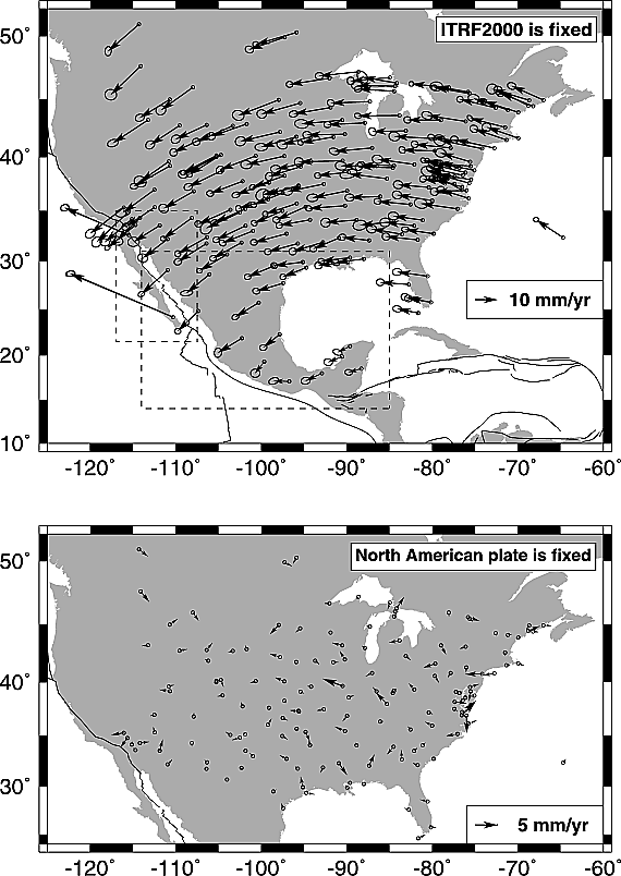
Velocities of GPS sites relative to ITRF2000. Dashed rectangles show areas depicted in Figures 9 and 10. Velocities of some Pacific and North American plate sites included in Figure 1 are not shown but are used in the analysis. Uncertainty ellipses are 2-D, 1b. All velocities are determined following correction of all GPS time series for common mode noise. (bottom) Residual velocities of North American plate sites in the United States, Bermuda, and southern Canada. Frame of reference is the North American plate. http://www.agu.org/journals/jb/jb0309/2002JB002241/figures.shtml. |
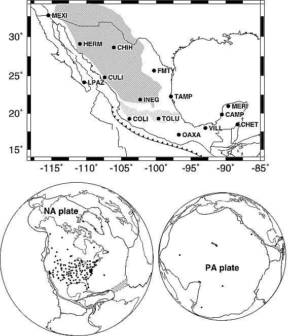
Locations and names of RGNA GPS sites. (bottom) Locations of continuous GPS sites on (left) North American plate and (right) http://www.agu.org/journals/jb/jb0309/2002JB002241/figures.shtml |
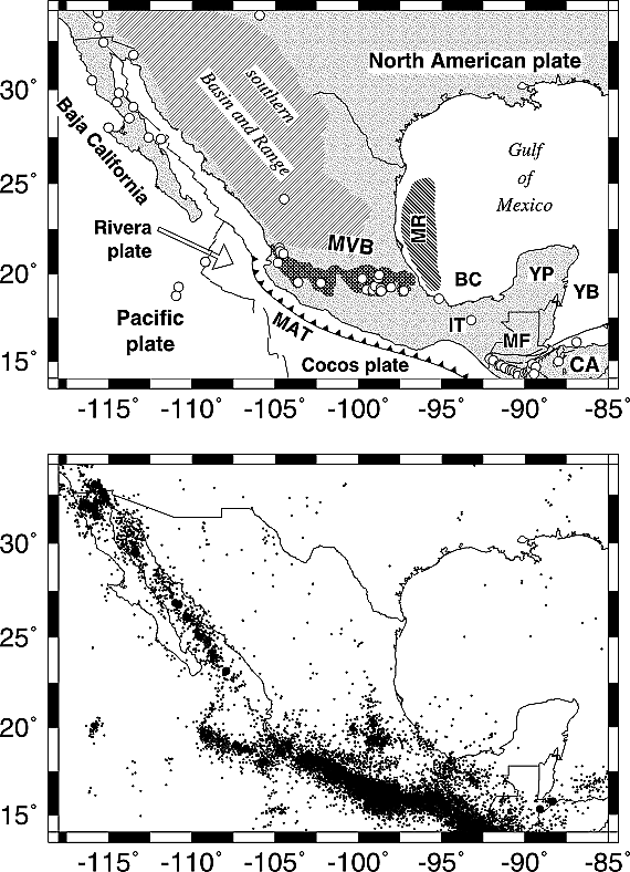
(top) Volcanotectonic setting of Mexico. Circles show locations of Quaternary volcanic eruptions. Limits of the southern Basin and Range province shown in this and subsequent Figures are defined by Stewart et al. [1998]. BC, Bay of Campeche; CA, Caribbean plate; IT, Isthmus of Tehuantepec; MAT, Middle America trench; MR, Mexican Ridges; MF, Motagua fault; MVB, Mexican Volcanic Belt; YB, Yucatan basin; YP, Yucatan Peninsula. (bottom) Small and large circles show earthquake epicenters with respective magnitudes of < 6.5 and >6.5 and depths above 60 km reported by U.S. Geological Survey for the period 1963–2002 and earthquakes of all magnitudes above depths of 30 km reported by the Mexican National Seismic Network for the period 1974–2001.http://www.agu.org/journals/jb/jb0309/2002JB002241/figures.shtml. JOURNAL OF GEOPHYSICAL RESEARCH, VOL. 108, NO. B9, 2450, doi:10.1029/2002JB002241, 2003 |
|
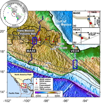
Location of the MASE and VEOX lines in central and southern Mexico, respectively.Two black boxes outline the Zitacuaro- Valle de Bravo (ZVB). The average distance between stations for both seismic lines is about 6 km. The regions of focus are shown by blue boxes. Two black boxes outline the Zitacuaro-Valle de Bravo (ZVB) and the Sierra Chichinautzin Volcanic Field (SCVF) in central Mexico. Gray lines depict isodepth contours of the subducted Cocos plate beneath the North American plate based on local seismicity and teleseismic receiver functions. The upper-left inset illustrates teleseismic earthquake locations used in the analysis (MASE, 28 events: blue; VEOX, 45 events: green). The upper-right inset shows geometries of the subducted oceanic crust in central (a) and southern (b) Mexico, constrained by the receiver functions.Distribution of hydrous minerals in the subduction system beneath Mexico. Teleseismic converted phases are used to probe the composition of the downgoing oceanic crust as a function of depth along the Cocos slab in central and southern Mexico. Previously, modeling of the receiver function (RF) conversion amplitude of the flat Cocos slab beneath central Mexico at 45 km depth revealed a thin low-velocity upper oceanic crust of a thickness of 4Ѓ}1 km, which has much lower seismic velocities (∼20–30% reduction in shear wave velocities) than (normal) lower crust. High Vp/Vs ratio (∼2.0) also suggested a large concentration of hydrous minerals such as talc in combination of high pore-fluid pressure in the horizontal segment. We extend this previous effort to examine seismic properties of both the steeply subducting Cocos oceanic crust beneath the Trans-Mexican Volcanic Belt (TMVB) in central Mexico and the shallowly dipping crust beneath southern Mexico. Inverted seismic velocities using the converted amplitudes at the top and bottom of the dipping oceanic crust are compared with experimentally constrained seismic velocities of candidate mineral phases in a range of likely pressures and temperatures. The composition of the oceanic crust downdip in the steep part of slab beneath the TMVB includes the minerals such as lawsonite and zoisite at 60–100 km depth, and the eclogitization occurs around 100 km depth. This is related to arc volcanism in the TMVB directly above the slab as well as the slab rollback. In contrast, the dominant mineral phase in the upper oceanic crust of southern Mexico beneath the Isthmus of Tehauntepec is amphibole on top of unaltered gabbroic oceanic crust. The difference in mineral assemblages of the subducted oceanic crust may help explain the difference in slab geometries between central and southern Mexico. http://www.sciencedirect.com/science/article/pii/S0012821X12002853 |
MGVF-Michoakan – Guanajuato Volcanic Field, VBZ -Valle de Bravo. Neogene volcanism at the front of the central Mexican volcanic belt: Basaltic andesites to dacites, with contemporaneous shoshonites and high-TiO2 lava As part of the continuing study of the young Mexican volcanic belt designed to document the ages and types of volcanism from the Gulf of California to the Valley of Mexico, a 50-km-wide segment of the central part of the belt has been mapped, and five types of lava have been found. Pliocene (3.77 Ma) shoshonite lava flows (K2O >2 wt%; SiO2 52–58 wt%) form eroded plateaus more than 50 km behind the present volcanic front, but in the past 1 m.y. shoshonites have erupted closer to the volcanic front (∼300 km from the Middle America Trench). The shoshonite lava type is the most enriched in Ba, Sr, and Zr of the suite, and plagioclase phenocrysts are absent, presumably because of high contents of dissolved water (3–5 wt%). Quaternary shield volcanoes and several cinder cones with small-volume lava flows are composed of high-TiO2 lavas (>1.2 wt%), which have 51–57 wt% SiO2, <6 wt% MgO, low Ni, Cr, Ba, and Sr, and high Nb (>9 ppm) and Zr (160–230 ppm). Pliocene high-TiO2 lava is found within the eroded plateaus located ∼50 km behind the present volcanic front. Quaternary basaltic andesite (52–57 wt% SiO2) with up to ∼10 wt% MgO is found at the volcanic front, along with more siliceous andesite (57–63 wt% SiO2). Representatives of the siliceous andesites (57–63 wt% SiO2) are free of plagioclase phenocrysts, low in Al2O3 (∼15.7 wt%), but rich in MgO (∼5 wt%). Experiments reported elsewhere suggest that the magmas contained 3–7 wt% dissolved water. This andesite erupted along a normal fault between ∼0.3 and 0.005 Ma, and it is associated with dacite, similarly lacking plagioclase phenocrysts, but having comparatively abundant pyroxene. Other dacite in the Zitacuaro area is richly porphyritic, having plagioclase and hornblende; this dacite forms clusters of steep-sided domes or widespread pyroclastic deposits, and the latest eruptions, dated by radiocarbon and K-Ar, occurred between 0.03–0.05 Ma. Estimates of the volume of magma erupted in the Zitacuaro–Valle de Bravo region in the past 1 m.y. (1.8 km3 • m.y.–1 • km–1) show that this area is somewhat less productive per 1 km of arc than those to the west (3.5 km3 • m.y.–1 • km–1) in the Michoacan-Guanajuato Volcanic Field (MGVF). A large volume of dacite has erupted in the Zitácuaro–Valle de Bravo region, which is rare in the MGVF. The cone density in the Zitacuaro–Valle de Bravo region (2.1/100 km2) is only slightly lower than the 2.6 cones/100 km2 found in the MGVF http://gsabulletin.gsapubs.org/content/113/10/1324.abstract |
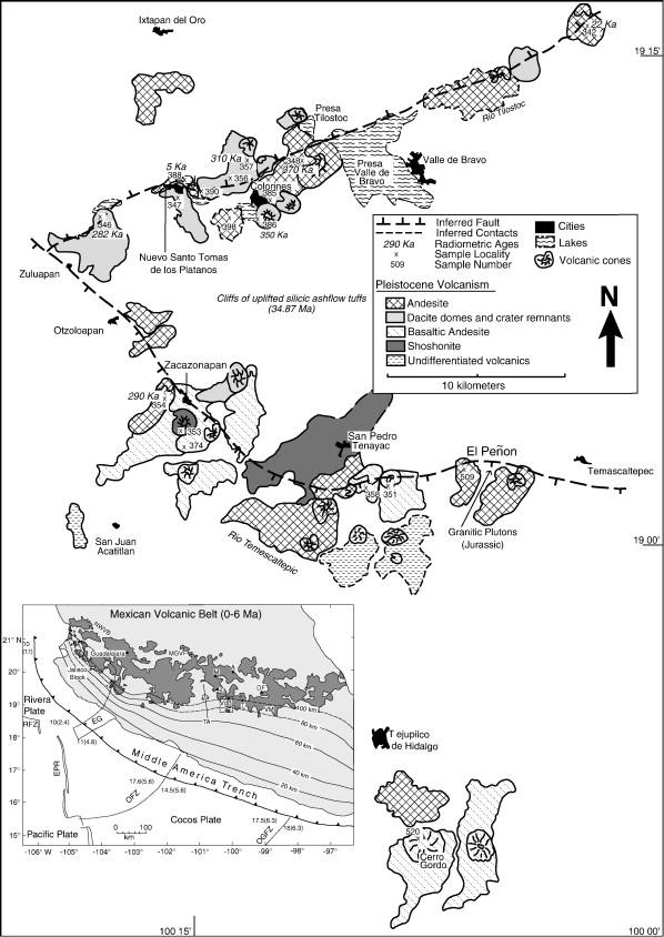
Volcanic deposits and sample localities in the Valle de Bravo region. The El Penon flow is labeled in the middle right of the map where the sample Z-509 is indicated. The index map in the lower left corner shows the outline of the area shown labeled VdB. The index map shows the entire Mexican Volcanic Belt with volcanism from zero to six Ma shown in dark grey; modified after Pasquare et al. (1991). The tectonic features are modified after Pardo and Suarez (1995). Abbreviations are: RFZ = Rivera Fracture Zone, EG = El Gordo Graben, EPR = East Pacific Rise, OFZ = Orozco Fracture Zone, OGFZ = O''Gorman Fracture Zone. The numbers along the Middle America Trench indicate the age of the subducting oceanic crust in million years (first number) and the convergence rate at that location in cm/yr (number in parenthesis); the black contours represent the depth to the subducted slab in km (Pardo and Suarez, 1995). Other abbreviations within the Mexican Volcanic Belt are NWVB = Northwest Volcanic Belt, MGVF = Michoacan–Guanajuato Volcanic Field (Hasenaka and Carmichael, 1985), M = Maravatio, A = Acambay, Z = Zitacuaro, VdB = Valle de Bravo, T = Nevado de Toluca, DF = Distrito Federal, VM = Valley of Mexico, and TA = Tzitzio Anticline.Peridotites in the mantle wedge and components added to them from the subducting slab are thought to be the source of most arc magmas. However, direct sampling of these materials, which provides a glimpse into the upper mantle beneath an active margin, is exceedingly rare. In the few arc localities where found, peridotite xenoliths are usually brought to the surface by basaltic magmas. Remarkably, the hornblende-bearing ultramafic xenoliths and clinopyroxene megaxenocrysts from El Penon in the central Mexican Volcanic Belt were brought to the surface by a Quaternary high-Mg siliceous andesite, a rock type usually considered too evolved to be a direct product of mantle melting. The xenoliths and megaxenocrysts from El Penon represent lithospheric mantle affected by significant subduction of oceanic lithosphere since as early as the Permian. Trace element and radiogenic isotope data we report here on these materials suggest a history of depletion by melt extraction, metasomatism involving a fluid phase, and finally, limited reaction between the ultramafic materials and the host andesite, probably during transport. They also show that high-Mg siliceous andesite can be a direct product of 1–5% melting of H2O-bearing spinel lherzolite.Keywords :peridotite xenoliths; arc settings; andesite; metasomatism; trace elements; radiogenic isotopes http://www.sciencedirect.com/science/article/pii/S0012821X07003056 |
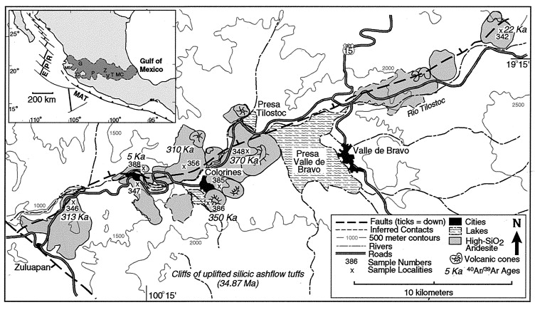
Geologic map of the Valle de Bravo area, central Mexico, showing Quaternary to Holocene volcanic deposits, 40Ar/39Ar ages, sample numbers, and major faults in relation to geographic features including cities, lakes, rivers, roads, and 500-m contours. The inset map shows the Mexican Volcanic Belt (shaded in dark gray). EPR = East Pacific Rise; MAT = Middle America Trench; MS = Mascota; C = Colima; G = Guadalajara; P = Paricutaэn; Z = Zitacuaro and Zitacuaro Volcanic Complex (Capra et al., 1997); V = Valle de Bravo; T = Toluca and Nevado de Toluca (Macias et al., 1997); MC = Mexico City. A group of Pleistocene-recent lavas, with 62 to 64% SiO2 and 5.6 to 3.5% MgO, have erupted along a linear fault system near the volcanic front of central Mexico. Not only is the composition of this group of lavas distinctive in comparison to andesites from other parts of the Mexican Volcanic Belt, but their typical pyroxene phenocryst assemblages may include hornblende and rarely plagioclase. Consequently, the experimental (water-saturated) P-T conditions, up to 3 kbar, necessary to reproduce the various phenocryst assemblages have been explored for the most Mg-rich andesite. The phenocryst assemblages in this group of lavas can be reproduced over a range of water concentrations (∼6 to ∼3 wt%) at temperatures consistent with those derived from phenocryst mineral geothermometers (910 to 1055Ѓ‹C). The phase fields of the phenocryst assemblages are ∼200Ѓ‹C below the water-saturated liquidus (>1100Ѓ‹C), which is defined by orthopyroxene, followed by olivine, ∼30Ѓ‹C below. However, the orthopyroxene and olivine assemblage has never been found in the Valle de Bravo lavas. Three observations are consistent with a mantle source for this andesitic lava that contains up to 176 ppm Ni and 257 ppm Cr. Both experimental liquidus olivine (Fo90) and orthopyroxene (En88) have compositions appropriate to a lherzolite source; the composition of a water-saturated partial melt of lherzolite at 1000Ѓ‹C and 10 kbar is comparable to these andesites. Last, a contemporaneous andesite lava that erupted along the same fault system contains nodules of hornblende-spinel-lherzolite, representative of the Mexican subarc mantle.http://www.sciencedirect.com/science/article/pii/S0016703701007086 Hydrous phase equilibria of a Mexican high-silica andesite:A candidate for a mantle origin? |
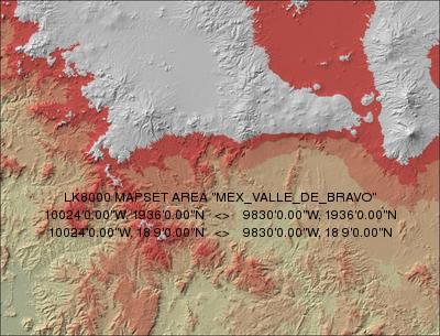
Valley de Bravo - all Mexico. High resolution maps - http://www.lk8000.it/lkmaps/MEX.html |
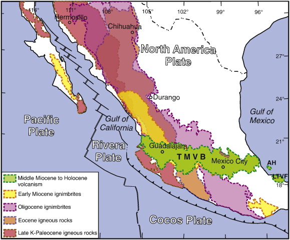
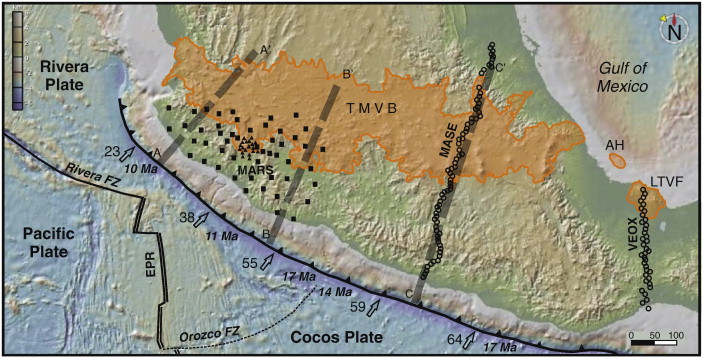
Geodynamic setting and main continental magmatic provinces of Mexico based on Ferrari et al. (2007) and our unpublished data. AH: Anegada high; LTVF: Los Tuxtlas volcanic field; TMVB: Trans-Mexican Volcanic Belt -http://www.sciencedirect.com/science/article/pii/S0040195111003957 The Trans-Mexican Volcanic Belt (TMVB) is a 1000 km long Neogene continental arc showing a large variation in composition and volcanic style, and an intra-arc extensional tectonics. It overlies the Rivera and Cocos slabs, which display marked changes in geometry. Geophysical studies indicate that lithospheric mantle is very thin or absent beneath the forearc and arc, the fluids from the slab are released in a 40 to 100 km wide belt beneath the frontal part of the arc, and the lower crust beneath the arc is partially molten. East of 101Ѓ‹W the TMVB is built on a Precambrian to Paleozoic crust with thickness of 50-55 km. West of 101Ѓ‹W the TMVB is underlain by Jurassic to Cenozoic marine and continental arcs with a 35-40 km thick crust. The evolution of the TMVB occurred in four stages: 1) from ~20 to 10 Ma the initial andesitic arc moved inland showing progressively drier melting and, eventually, slab melting, suggesting flattening of the subducted slab; 2) since ~11 Ma a pulse of mafic volcanism migrated from west to east reaching the Gulf of Mexico by 7 Ma. This mafic lavas marks the lateral propagation of a slab tear, triggered by cessation of subduction beneath Baja California |
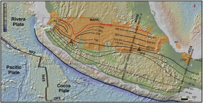
Depth of the subducted slab beneath central Mexico compiled using the results of receiver function and tomography studies from the MARS, MASE and VEOX experiments. The geometry of Pardo and Suarez (1995) was used in areas not covered by these studies. Co = Colima volcano; Po = Popocatepetl volcano. The dynamic history of the Trans-Mexican Volcanic Belt and the Mexico subduction zone The Trans-Mexican Volcanic Belt (TMVB) is a 1000 km long Neogene continental arc showing a large variation in composition and volcanic style, and an intra-arc extensional tectonics. It overlies the Rivera and Cocos slabs, which display marked changes in geometry. Geophysical studies indicate that lithospheric mantle is very thin or absent beneath the forearc and arc, the fluids from the slab are released in a 40 to 100 km wide belt beneath the frontal part of the arc, and the lower crust beneath the arc is partially molten. East of 101Ѓ‹W the TMVB is built on a Precambrian to Paleozoic crust with thickness of 50–55 km. West of 101Ѓ‹W the TMVB is underlain by Jurassic to Cenozoic marine and continental arcs with a 35–40 km thick crust.The evolution of the TMVB occurred in four stages: 1) from ~ 20 to 10 Ma the initial andesitic arc moved inland showing progressively drier melting and, eventually, slab melting, suggesting flattening of the subducted slab; 2) since ~ 11 Ma a pulse of mafic volcanism migrated from west to east reaching the Gulf of Mexico by 7 Ma. This mafic lavas marks the lateral propagation of a slab tear, triggered by cessation of subduction beneath Baja California; 3) thereafter, the volcanic front started moving trenchward, with a marked phase of silicic volcanism between 7.5 and 3 Ma, local emplacement of small volume intraplate-like basalts since 5 Ma, and development of extensional faulting. These features are related to slab rollback, enhancing asthenophere flux into the mantle wedge and promoting partial melting of the crust; 4) the modern arc consists of a frontal belt dominated by flux and slab melting, and a rear belt characterized by more differentiated rocks or by mafic lavas with little or no evidence of subduction fluids but higher asthenosphere fingerprint. Trans-Mexican Volcanic Belt; Cocos plate; Rivera plate; Subduction dynamics; Arc volcanism; Mexico crust and lithosphere - http://www.sciencedirect.com/science/article/pii/S0040195111003957 |
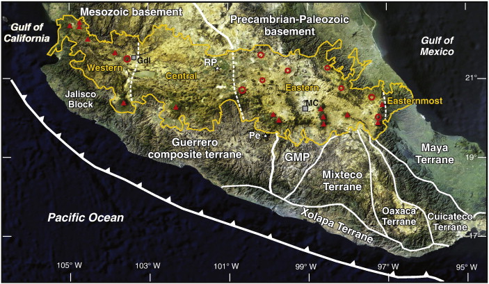
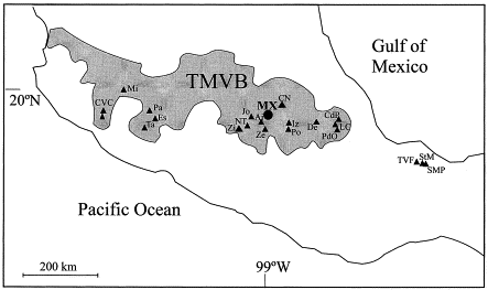
MODIS satellite image of central Mexico outlining the Trans-Mexican Volcanic Belt (yellow line) with the main stratovolcanoes (red triangles) and calderas (red circles) as well as the four sectors described in Table 1 (thin dashed white lines). The main crustal units are outlined with thick white lines. The eastern boundary of the Mesozoic Guerrero composite terrane is inferred either on the west (Campa and Coney, 1983) or on the east (Sedlock et al., 1993) of the Guerrero-Morelos platform (GMP), but continental crust may extend even more to the west as indicated by sialic crustal xenoliths found at Pepechuca (Pe) and Rincуn de Parangueo (RP). The Jalisco block is part of the Guerrero composite terrane and might be also underlain by pre-Mesozoic crust according to ОµNd values and Nd model ages of its Cretaceous granitoid batholiths. MC: Mexico City; Gdl: Guadalajara. |
Location of broadband seismic stations used in the MARS experiment (black squares) and in the Colima Volcano Deep Seismic Experiment (CODEX) (black triangles) (Yang et al., 2009), MASE and VEOX profiles (open circles) ( [Melgar and Perez-Campos, 2011] and [Pйrez-Campos et al., 2008]), and the 2D thermal models presented in Manea, V. and Manea (2011) and this work (gray dashed lines). The boundaries of the Pacific, Rivera and Cocos oceanic plates as well as the age of the subducting plate at the trench are also indicated. Small arrows show direction and relative convergence rate (mm/yr) at the trench. FZ = Fracture Zone; EPR = East Pacific Rise; AH = Anegada High; LTVF = Los Tuxtlas volcanic field. |
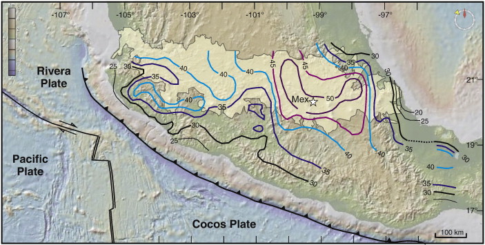
Map showing the thickness of the crust beneath and south of the TMVB (in km). Moho depth compiled using the results of receiver function studies from the MARS, MASE and VEOX experiments as well as the gravimetric model of Urrutia-Fucugauchi and Flores-Ruiz (1996). MARS results courtesy of Steve Grand |
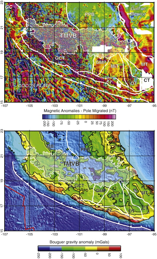
) Map of aeromagnetic anomalies migrated to the pole for central Mexico. Data from the Aeromagnetic Map of North America (North America Magnetic Anomaly Group, 2002). Main crustal units and TMVB outline as in Fig. 2. B) Bouguer anomaly map of central Mexico based on the gravimetric map of Mexico (De la Fuente et al., 1994). |
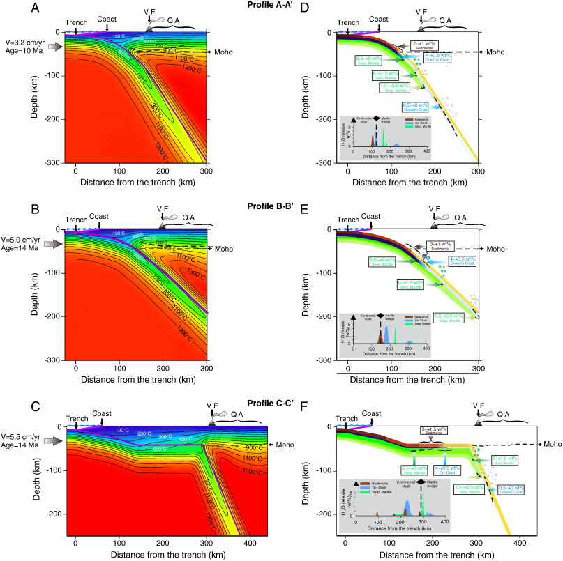
instantaneous thermal models and estimated amount of water released during subduction for the profiles in Fig. 3. Profiles A and B are constrained by the slab and crustal geometry of profiles A-A'' and D-D'' of the MARS experiment (Yang et al., 2009). Profile C-C'' (modified from Manea, V. and Manea, 2011) is constrained by the slab and crustal geometry of the MASE line (Pйrez-Campos et al., 2008). See Appendix A for details.-http://www.geociencias.unam.mx/geodinamica/research/research/mexico/tmvb/tmvb2.php |
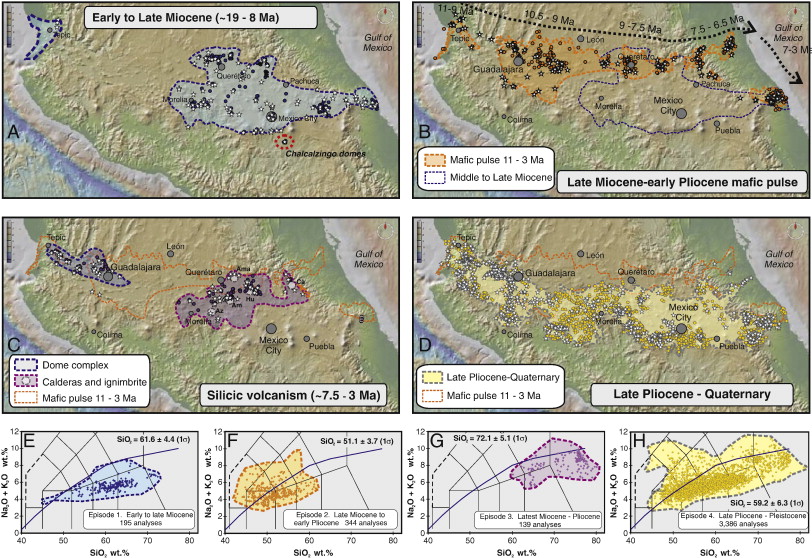
The four magmatic episodes of the Trans-Mexican volcanic belt. Location of samples in the database are represented by dots (chemical analyses) and stars (age). Also shown is the composition of volcanics in the total alkalies vs. silica (TAS) diagram (Le Bas et al., 1986) for each episode, including mean SiO2 values and number of analyses. A) and E) The early TMVB of early to late Miocene; B) and F) The eastward migrating mafic pulse of the late Miocene to early Pliocene; C) and G) The silicic episode of the late Miocene to early Pliocene; D) and H) The modern TMVB of late Pliocene to Pleistocene |
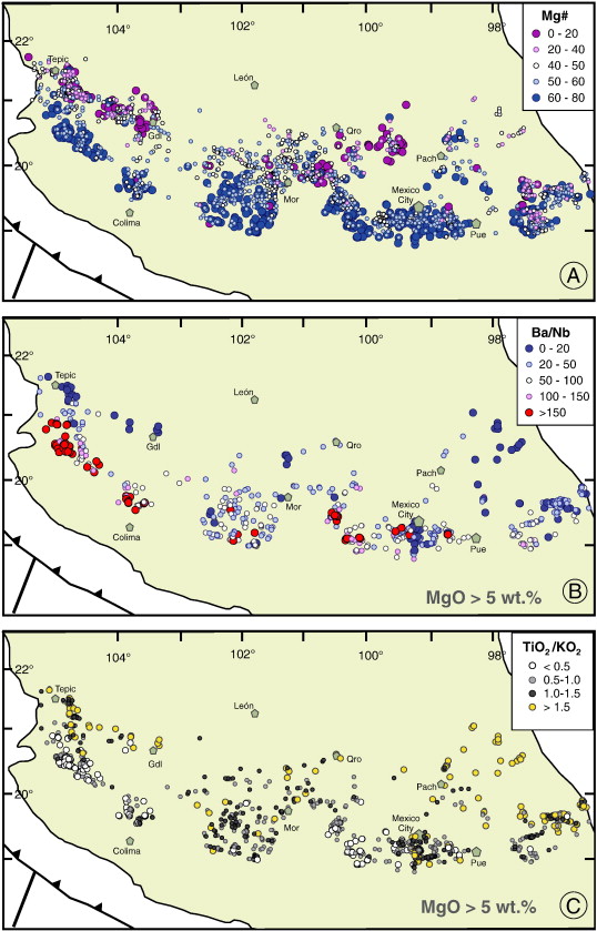
Late Pliocene-Holocene episode. Maps showing the geographic distribution of (A) Mg# values, (B) Ba/Nb ratios, and (C) TiO2/K2O ratios. Data set used in B and C was limited to samples with MgO > 5 wt.% in order to reduce fractionation effects |
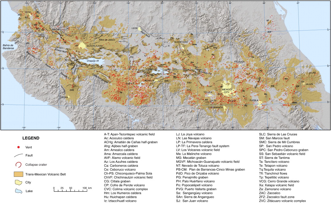
Tectonic and volcanic structures of the Trans-Mexican Volcanic Belt updated from Ferrari et al. (2005b).- http://www.sciencedirect.com/science/article/pii/S0040195111003957 |
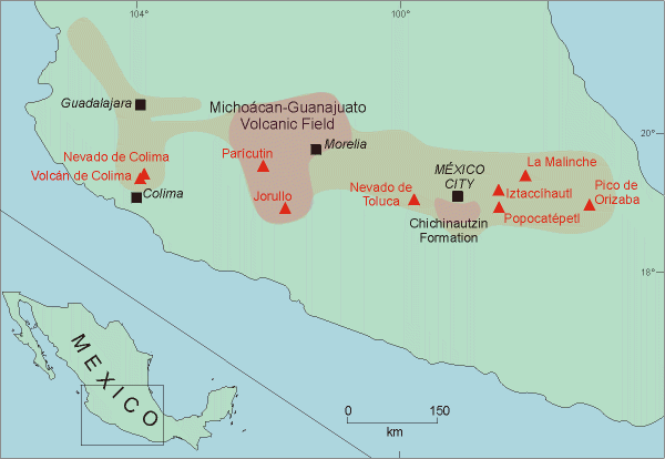
A very generalised map of central Mexico (Tephra base - http://www.tephrabase.org/index.html) |
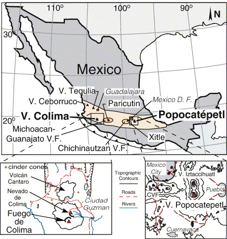
Location of Colima and Popocatepetl volcanic complexes in relation to other major eruptive centers along the Trans Mexican Volcanic Belt (tan shadedarea). Inset left shows the Colima volcanic complex and is modified from Luhr and Carmichael (1980). Inset right is for the Popocatepetl-Iztaccihuatl Complex and is modified from Martin Del Pozzo et al. (2003).Melt inclusions in phenocrysts from Volcбn Popocatepetl and Volcбn de Colima within the Trans Mexican Volcanic Belt (TMVB) are dacitic to rhyolitic. Trends in melt inclusion major element and water concentrations form the evolved extension of other Mexican volcanics including those presumed to be derived directly from primitive melts. Water concentrations in Popocatepetl and Colima melt inclusions are similar (0.3 to 3.4 wt.% H2O). Melt-vapor equilibration pressures calculated from dissolved H2O and CO2 (Popocatepetl) or H2O (Colima) in melt inclusions correspond to depths of entrapment of 12 km or less. Water and carbon dioxide concentrations correlate negatively with SiO2 and potassium. Normalized olivine–augite–quartz compositions are consistent with near cotectic crystallization under vapor-saturated conditions at pressures of 1.5 kb or less. Our results show that Popocatepetl and Colima magmas have undergone vapor-saturated crystallization during ascent in conjunction with varying degrees of mixing between degassed rhyodacitic and less degassed, mafic melts in the upper portions of the crust. These data suggest melt evolution occurred in conduits or inter-fingered dikes rather than a large stratified magma chamber-http://www.sciencedirect.com/science/article/pii/S0377027305003938 |
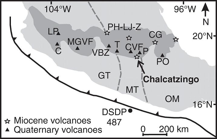
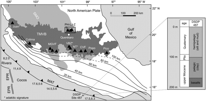
Tectonic map of the Mexican subduction zone (modified from Pardo and Suárez, 1995). Numbers separated by commas along the trench indicate the age (Ma) and convergence rate (cm/yr) of the subducting plates. Depth contours of the subducting plates are also shown (dashed lines when inferred). The Trans-Mexican Volcanic Belt (TMVB) has an E-W preferred orientation, whereas the Oligocene Sierra Madre Occidental magmatic province (SMO) extends with a NNW-SSE orientation. The study area is depicted by a box: Palo Huérfano–La Joya–Zamorano Volcanic Complex (PH–LJ–Z). Important Mexican volcanoes are included as reference: Pico de Orizaba Volcano (Pico), Popocatepetl Volcano (Popo), Chichinautzin Volcanic Field (CVF), Nevado de Toluca Volcano (NT), Valle de Bravo-Zitácuaro Volcanic Field (VBZ), Michoacán-Guanajuato Volcanic Field (MGVF), Colima Volcano (Colima), San Juan Volcano (S. Juan). Also shown are the lithology and stratigraphy of the Cocos plate sampled at DSDP Site 487 (LaGatta, 2003). Asterisks indicate Quaternary locations of adakitic magmatism: NT (Martinez-Serrano et al., 2004), VBZ (Gomez-Tuena et al., 2007a), S Juan (Luhr, 2000). EPR = East Pacific Rise; MAT = Middle American Trench.Effects of prolonged flat subduction on the Miocene magmatic record of the central Trans-Mexican Volcanic Belt. Temporal changes in the chemical compositions of middle to late Miocene rocks from the central Trans-Mexican Volcanic Belt elucidate how prolonged flat subduction influences arc magmatism. These are recorded in the Palo Huérfano–La Joya–Zamorano Volcanic Complex (PH–LJ–Z; 12–10 Ma), a group of andesitic to dacitic stratovolcanoes located at ∼ 500 km from the trench; and in the Querétaro Volcanic Succession (QVS; 9–6 Ma), a basaltic to basaltic–andesitic plateau that stratigraphically overlies the stratovolcanoes. The two rock-groups display trace element patterns that are typical of arc magmas, but the PH–LJ–Z suite shows higher Sr/Y and Gd/Yb ratios than the QVS, and a few PH–LJ–Z samples also display Sr isotopic ratios that are similar to those of the East Pacific Rise mid-ocean ridge basalts. These features are typical of adakitic magmas. In contrast, QVS rocks display an overall weaker subduction signature (e.g. lower Ba/Nb ratios), do not show adakite features, and have lower SiO2/(MgO + Fe2O3tot) ratios at equivalent Mg# (∼ 40–70), MgO and Na2O contents than the PH–LJ–Z suite. Since Fe in arc magmas is a sensitive proxy of water content or melting pressure, and Na may reflect the thickness of the mantle column that controls the extent of melting, the overall chemical differences of both suites can only be reconciled if they equilibrated with the mantle wedge at roughly the same pressures but with different amounts of dissolved water. Once formed, both magmatic suites also suffered contamination at different crustal levels during ascent, but their primary compositional differences are mainly related to different mechanisms of element recycling that occurred without major changes in the local tectonic configuration. The adakite features of PH–LJ–Z rocks, and their emplacement at a large distance from the trench, are consistent with a sub-horizontal subduction geometry that favored slab melting at relatively low pressures. On the other hand, a protracted flat subduction will most likely produce a gradually cooler thermal structure in the subduction zone, hindering slab melting, and instead favoring slab dehydration and fluid fluxing of the mantle wedge as a mechanism to form the more typical arc volcanics of the QVS. Keywords: Arc; Slab melting; Adakite; Mantle; Mexico; Crust - http://www.sciencedirect.com/science/article/pii/S0009254107003014 |
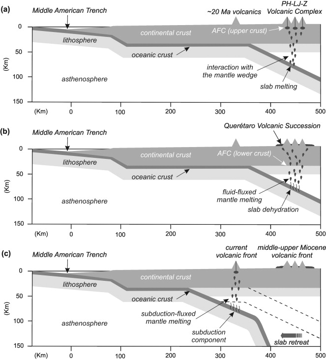
Effects of prolonged flat subduction on the Miocene magmatic record of the central Trans-Mexican Volcanic Belt . A tectonic–petrogenetic model for the Miocene magmatic episodes of the TMVB. (a) The oldest volcanic rocks (∼ 20 Ma) of the TMVB were emplaced at ∼ 300 km from the trench. Between ∼ 12 and 10 Ma the volcanic front migrated to ∼ 500 km from the trench, suggesting a transition to a low subduction angle which contributed to anomalous heating of the subducted plate and favored slab melting (Gomez-Tuena et al., 2003). Slab melts interacted with the mantle wedge during their ascent to the surface and acquired their high Mg#. (b) Between ∼ 9–6 Ma protracted flat subduction produced a gradually cooler thermal structure, and slab melting was replaced by slab dehydration. Injection of slab-derived fluids into the mantle wedge induced partial melting and generation of the more typical arc basalts of the QVS. (c) Volcanism was extinguished in the area at ∼ 6 Ma, but gradually migrated closer to the trench since the early Pliocene. On simple geometrical grounds, the progressive southwards migration of volcanism might be explained by assuming that the cooler and denser slab eventually retreated. http://www.sciencedirect.com/science/article/pii/S0009254107003014 Temporal changes in the chemical compositions of middle to late Miocene rocks from the central Trans-Mexican Volcanic Belt elucidate how prolonged flat subduction influences arc magmatism. These are recorded in the Palo Huérfano–La Joya–Zamorano Volcanic Complex (PH–LJ–Z; 12–10 Ma), a group of andesitic to dacitic stratovolcanoes located at ∼ 500 km from the trench; and in the Querétaro Volcanic Succession (QVS; 9–6 Ma), a basaltic to basaltic–andesitic plateau that stratigraphically overlies the stratovolcanoes. The two rock-groups display trace element patterns that are typical of arc magmas, but the PH–LJ–Z suite shows higher Sr/Y and Gd/Yb ratios than the QVS, and a few PH–LJ–Z samples also display Sr isotopic ratios that are similar to those of the East Pacific Rise mid-ocean ridge basalts. These features are typical of adakitic magmas. In contrast, QVS rocks display an overall weaker subduction signature (e.g. lower Ba/Nb ratios), do not show adakite features, and have lower SiO2/(MgO + Fe2O3tot) ratios at equivalent Mg# (∼ 40–70), MgO and Na2O contents than the PH–LJ–Z suite. Since Fe in arc magmas is a sensitive proxy of water content or melting pressure, and Na may reflect the thickness of the mantle column that controls the extent of melting, the overall chemical differences of both suites can only be reconciled if they equilibrated with the mantle wedge at roughly the same pressures but with different amounts of dissolved water. Once formed, both magmatic suites also suffered contamination at different crustal levels during ascent, but their primary compositional differences are mainly related to different mechanisms of element recycling that occurred without major changes in the local tectonic configuration. The adakite features of PH–LJ–Z rocks, and their emplacement at a large distance from the trench, are consistent with a sub-horizontal subduction geometry that favored slab melting at relatively low pressures. On the other hand, a protracted flat subduction will most likely produce a gradually cooler thermal structure in the subduction zone, hindering slab melting, and instead favoring slab dehydration and fluid fluxing of the mantle wedge as a mechanism to form the more typical arc volcanics of the QVS. Keywords Arc; Slab melting; Adakite; Mantle; Mexico; Crust |
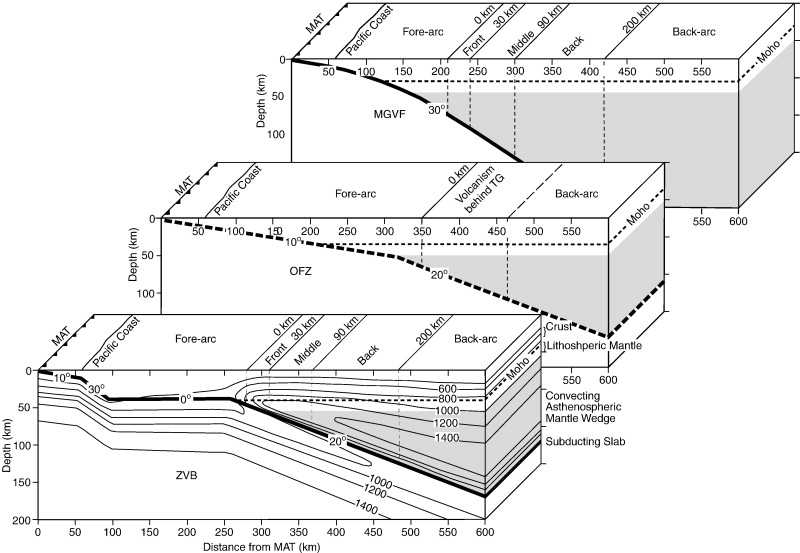
Impact of the Orozco Fracture Zone on the central Mexican Volcanic Belt . Schematic illustration of the subduction geometry and distribution of Quaternary volcanism in three adjacent segments of the central MVB arc. Top section: MGVF with subduction angle taken from Pardo and Suarez (1995) and crustal thickness from Urrutia-Fucugauchi and Flores-Ruiz (1996). Middle section: OFZ with estimated subduction angle of 10Ѓ‹ and crustal thickness from Urrutia-Fucugauchi and Flores-Ruiz (1996). Bottom section: ZVB with subduction configuration, isotherms, and crustal thickness modified from Manea et al. (2005). Note that the front of volcanism is off-set ~ 100 km toward the back of the arc in the OFZ section compared to the MGVF and ZVB http://www.sciencedirect.com/science/article/pii/S0377027309003163 This study investigates a prominent indentation in the central Mexican Volcanic Belt (MVB), referred to as the Tzitzio Gap (TG). In this region, centered at 101Ѓ‹ W, Quaternary volcanism is displaced approximately 100 km toward the back of the arc. This embayment is roughly aligned with the projected position of the Orozco Fracture Zone (OFZ), which separates segments of the Cocos Plate that differ in age by approximately 5 Ma. The fracturing of the oceanic lithosphere associated with the OFZ appears to have caused alteration and increased the buoyancy of this ~ 100 km-wide linear feature. Several indicators of the buoyancy of the OFZ have been reported, including shallowing of the Middle America Trench (MAT), seaward advancement of the shoreline, and the uplift and exposure of deeply buried and deformed Jurassic to Oligocene rocks that comprise the TG region.Arc volcanism in the regions surrounding the TG provides constraints on the subduction of the OFZ. In the central MVB, enrichment in fluid-mobile elements such as Ba, Sr, P2O5, Pb and K2O typically decreases with distance from the Middle America Trench, consistent with progressive dehydration of the down-going slab. Numerous studies in the central MVB have demonstrated that this fluid-mobile element enriched signature results from flux-induced melting at the front of the arc, while decompression melting of asthenospheric mantle peridotite is dominant at the back of the arc. The data presented here (a compilation of available geochemical data and new XRF major and trace element analyses of lavas erupted adjacent to the TG) shows that the volcanism that occurs behind the TG exhibits an anomalous fluid signature (high K2O, P2O5, Ba, and Pb) superimposed on compositions similar to those from the extensional regions in northern Mexico.We propose that these distinctive structural and geochemical characteristics arise from subduction of the OFZ. Increased buoyancy of the fracture zone may cause it to subduct at a shallower angle. Therefore, the OFZ portion of the slab reaches the P/T conditions for de-volatilization further from the Middle America Trench, resulting in the profound offset of the arc toward the back and the fluid signature from the slab superimposed on back-arc, extension-related intraplate basalts. Keywords: central Mexican Volcanic Belt; Orozco Fracture Zone;fracture zone subduction; geochemistry |
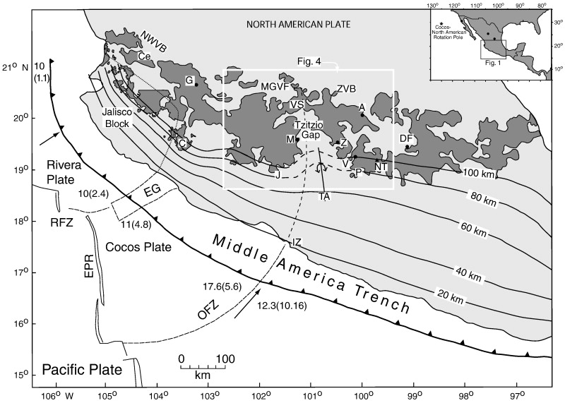
Map of the Mexican Volcanic Belt with Quaternary volcanism shown in dark gray. The inset box shows the area covered by this figure, the location of the Cocos–North American Pole of rotation, and the black dots are locations for the Northern Mexico Extensional Province (NMEP) samples (Luhr et al., 2006; MEXPET database, Siebert et al., 2003). The white box outlines the area shown in Fig. 4. The tectonic features are modified from Pardo and Suarez (1995) and abbreviations are: RFZ = Rivera Fracture Zone, EG = El Gordo Graben, EPR = East Pacific Rise, and OFZ = Orozco Fracture Zone. The numbers along the Middle America Trench are from Pardo and Suarez (1995), and Kanjorski (2003), and denote the age of the subducting oceanic lithosphere in million years (first number) and the convergence rate at that location in cm/yr (number in parentheses). The depth to the subducting slab in km (from Pardo and Suarez (1995)) is shown with solid black contours. The dashed portions of these contours represent deflection of the subducting plate beneath the Tzitzio Gap due to subduction of the OFZ. The dotted line delineates the boundary of the Jalisco Block. Other abbreviations within the Mexican Volcanic Belt are MGVF = Michoacбn-Guanajuato Volcanic Field (Hasenaka and Carmichael, 1985), ZVB = Zitacuaro–Valle de Bravo Transect, VS = Valle de Santiago, NWVB = Northwest Volcanic Belt, A = Amealco Caldera (Aguirre-Diaz and McDowell, 2000), M = Morelia, Z = Zitacuaro, V = Valle de Bravo, P = El Penon, TA = Tzitzio Anticline, NT = Nevado de Toluca, DF = Distrito Federal, G = Guadalajara, IZ = Ixtapa Zihuantanejo, J = Jorullo, C = Nevado de Colima, and Ce = Ceboruco. Note the association of the Tzitzio Gap with the subduction trajectory of the OFZ. http://www.sciencedirect.com/science/article/pii/S0377027309003163 |
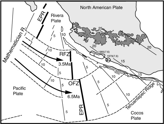
Generalized tectonic map of Mexico. Location of East Pacific Rise (EPR — heavy solid lines), fracture zones (dashed lines), and isochrons (medium weight lines) are adapted from Mammerickx and Klitgord (1982). Ages of isochrons are shown with numbers. Bathymetry of the trench (fine weight lines marked with depth in meters) and estimated projection of isochrons beneath the North American Plate adapted from Nixon (1982). Aftershock zones for the 1979 and 1985 large earthquakes are shown according to Ruff and Miller (1994). Foci are shown with stars. The date of each earthquake is shown followed by magnitude in parentheses. Large arrows show spreading-ridge jumps at 3.5 Ma and 6.5 Ma (after Luhr et al. (1985)). http://www.sciencedirect.com/science/article/pii/S0377027309003163 |
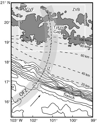
Map showing the relationship between the bathymetry (solid lines offshore, depth interval is 500. Modified after Ruff and Miller (1994)) and the OFZ. The land is shaded light gray and the MVB is in dark gray. Contours of depth to the subducting slab (Pardo and Suarez, 1995) are shown as dashed lines. The arrow shows the convergence direction between the Cocos and North American Plates. The path of the OFZ beneath the North American Plate is shown as a dashed line. The shaded area to either side of the dashed line delineates the estimated 100 m width of the fracture zone. Note the shallow trench where the OFZ is consumed and the correlation of the OFZ with the gap in front and middle zones of the Quaternary arc volcanism. The white box outlines the region shown in Fig. 4. IZ = Ixtapa Zihuantanejo http://www.sciencedirect.com/science/article/pii/S0377027309003163 |
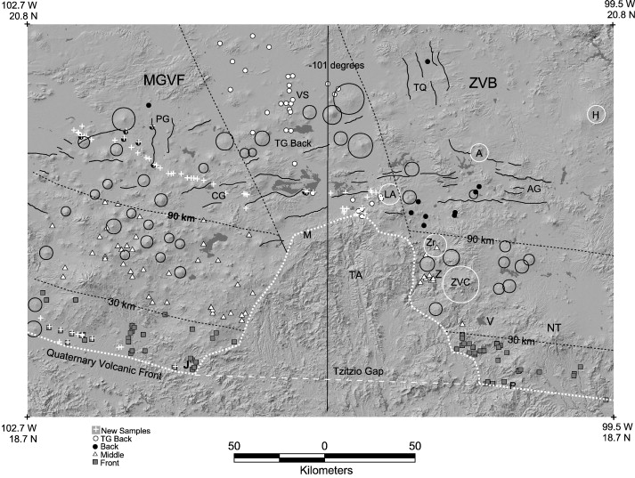
Fig4.DEM constructed from 90 meter SRTM (Shuttle Radar Topography Mission) data available from the USGS National Map Seamless Data Distribution System at a scale of 1:1,316,602. Superimposed on the DEM are locations for samples that met our criteria to be considered primitive (or near-primitive). Nearly all of these locations are monogenetic cones and are keyed to the legend on the map. The white short-dashed line traces the Quaternary volcanic front and shows the ~ 100 km indentation in the volcanic front, referred to as the Tzitzio Gap (TG). The white long-dashed line shows the position of where the Quaternary volcanic front would cross the TG if it were not deflected by subduction of the buoyant OFZ. The distance to the arc front for each sample was measured perpendicular to this white long-dashed line or the white short-dashed lines that extend on each side to the east and west. The black vertical line is drawn at 101Ѓ‹ west and separates the region into two segments: east or west. The fine, black, solid lines are the traces of faults, taken from Suter et al. (1995) and inferred from the DEM image and field observations. The fine, black, dashed lines delineate the zones of the arc: front = 0–30 km, middle = 30–90 km, and back = 90–208 km. TG back is the area of the back zone that is affected by OFZ subduction. The black circular outlines are shield volcanoes, the white circular outlines are silicic centers and calderas. Abbreviations are: LA = Los Azufres caldera, A = Amealco caldera, H = Huichipan caldera, TA = Tzitzio Anticline, J = Jorullo, V = Valle de Bravo, ZVC = Zitacuaro Volcanic Complex, Zr = Zirahuato domes, NT = Volcan Nevado de Toluca, P = El Penon, M = Morelia, PG = Penajamillo Graben, CG = Cuitzeo Graben, TQ = Taxco-Queretaro fault system, and AG = Amealco Graben. Dark gray irregular polygons are reservoirs and lakes or areas without elevation data - http://www.sciencedirect.com/science/article/pii/S0377027309003163 |
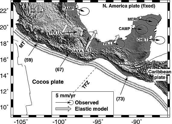
Observed GPS velocities at sites in southern Mexico compared to velocities predicted from elastic half-space modeling of the Rivera-North America, Cocos-North America, and Cocos-Caribbean subduction interfaces. All velocities are relative to the North American plate. Offshore velocity arrows are predicted plate convergence velocities (see text), with rates in millimeters per year specified by the numbers within the parentheses. Dashed line designates location of the Tehuantepec fracture zone (TFZ). MT designates the Manzanillo trough, an offshore graben assumed here to separate subducting Rivera plate lithosphere to the northwest from subducting Cocos plate lithosphere to the southeast. The three subduction interfaces are divided into subfaults, each of which is assumed to accumulate strain in the predicted plate convergence direction at the full, geographically varying plate rate (see text). Circles depict the upper midpoint of each subfault. Faults that accommodate 20 mm yr-1 of sinistral slip between the Caribbean and North American plates contribute negligible additional motion (<0.1 mm yr-1) at these sites.http://www.agu.org/journals/jb/jb0309/2002JB002241/figures.shtml |
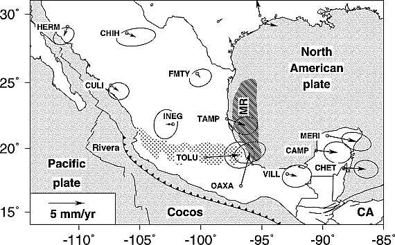
RGNA site velocities after removing motion of North American plate predicted by the best fitting North America-ITRF2000 angular velocity vector. Uncertainty ellipses are 2-D, 1b. CA, Caribbean plate; MR, Mexican Ridges deformation belt. Stippled area shows extent of Mexican Volcanic Belt. http://www.agu.org/journals/jb/jb0309/2002JB002241/figures.shtml |
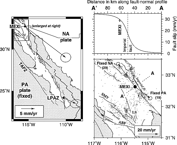
(left) Motions of LPAZ and MEXI relative to the Pacific plate. TAFZ, Tosco-Abreojos fault zone [Spencer and Normark, 1979]. (top right) Slip rates along profile A-A'' predicted by a homogeneous elastic half-space model that assumes the Imperial fault is a 60-km-long vertical strike-slip fault that accumulates a 35 mm yr-1 slip deficit from the surface to 7.5 km depth. Predicted and observed slip rates are relative to the North American plate. (bottom right) Motion of MEXI relative to the Pacific (PA) and North American (NA) plates. Numbers in parentheses are rates in units of millimeters per year. Uncertainty ellipses are 2-D, 1b. Dashed line shows locations of fault-normal profile A-A''. ABF, Agua Blanca fault; LS, Laguna Salada fault; SMV, San Miguel-Vallecitos fault http://www.agu.org/journals/jb/jb0309/2002JB002241/figures.shtml. |
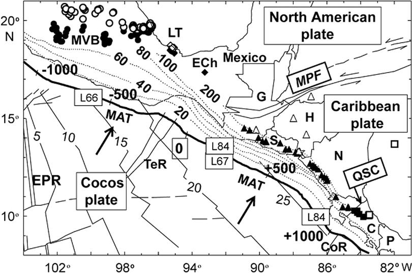
The Trans-Mexican Volcanic Belt is at an angle to the Middle American Trench.The Middle American Trench, in which the Cocos Plate is subducted beneath the North American Plate, runs parallel to the south coast of Mexico. Like many subduction zones, this feeds a chain of volcanoes, the Trans-Mexican Volcanic Belt, as the subducting plate is melted by the heat of the Earth''s interior and melts, some of the melted material then rising through the overlying plate as magma, feeding the volcanoes of the Volcanic Belt. However this Volcanic Belt runs parallel to neither the subduction zone nor the coast, but runs across Mexico at an angle, which requires an explanation. http://sciencythoughts.blogspot.com/2012/03/understanding-subduction-zone-beneath.html |
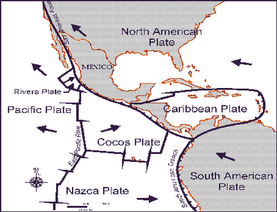
The position of the Cocos, Nazca and Rivera Plates. The Cocos Plate is thought to have formed about 23 MA, when the Farallon Plate, an ancient tectonic plate underlying the East Pacific, split in two, forming the Cocos Plate to the north and the Nazca Plate to the south. Then, roughly 10 million years ago, the northwesternmost part of the Cocos Plate split of to form the Rivera Plate, south of Beja California. http://sciencythoughts.blogspot.com/2012/03/understanding-subduction-zone-beneath.html |
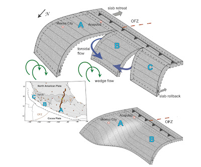
The new model of the Cocos Plate beneath Mexico, split into two sections (A & B) subducting at differing angles. (C) Represents the Rivera Plate, subducting at a steeper angle than either section of the Cocos Plate. The Split between the two has been named the Orozco Fracture Zone (OFZ) which is shown extended across the Cocos Plate; in theory this might in future split the Cocos Plate into two segments (though not on any human timescale). Bottom Left, the position of the segments on a map of Mexico. Darker area is the Trans-Mexican Volcanic Belt, orange circles are volcanoes, brown triangles are seismic monitoring stations, yellow stars are major cities. Bottom Right, an alternative model showing the subducting plate twisted but not split. This did not fit the data Stubailo et al. (2012).The seismic monitoring stations were able to monitor not just Earthquakes in Mexico, but also Earthquakes in other parts of the world, monitoring the rate at which compression waves from these quakes moved through the rocks beneath Mexico, and how the structure of the rocks altered the movement of these waves.Based upon the results from these monitoring stations, Stubailo et al. came to the conclusion that the Cocos Plate was split into two beneath Mexico, and that the two plates are subducting at different angles, one steep and one shallow. Since the rate at which a plate melts reflects its depth within the Earth, the steeper angled plate melts much closer to the subduction zone than the shallower angled plate, splitting the Trans-Mexican Volcanic Belt into sections above the different segments of the Cocos Plate, and causing it to apparently curve away from the subduction zone.http://sciencythoughts.blogspot.com/2012/03/understanding-subduction-zone-beneath.html |
Zitacuaro -The Zitacuaro Volcanic Complex (ZVC) rises on a basement of metamorphic rocks of Late JurassicуEarly Cretaceous age, and volcanic rocks, limestones, and red beds of Cretaceous age. Volcanic activity related to the Trans-Mexican Volcanic Belt started during Early Miocene with the eruption of calc-alkaline andesites that formed a primitive stratovolcano covering an area about 30 km x 15 km. A major change in eruptive style occurred during Middle Miocene, when a caldera structure formed, "Las Tres Chicas Caldera", approximately 30 km in diameter and dated about 12 Ma. Post-caldera activity consisted of three eruptive episodes of intraуcaldera dome resurgence around 12 Ma, 5 Ma, and 0.5 Ma. Each episode featured the intrusion of dacitic central domes, the generation of pyroclastic flows and peri-caldera andesitic lava flows. The activity at the ZVC features recurrent volcanic episodes, the most recent one with emplacement of young resurgent domes such as Cacique. Local seismic activity in the area felt at Zitбcuaro, is persistent. The ZVC should be considered as a potentially active volcanic zone. KEY WORDS: Trans-Mexican volcanic belt, caldera, resurgent domes. http://www.geofisica.unam.mx/unid_apoyo/editorial/publicaciones/investigacion/geofisica_internacional/anteriores/1997/03/capra.html |
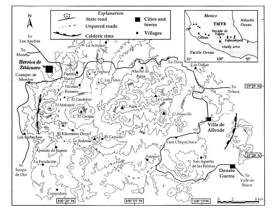
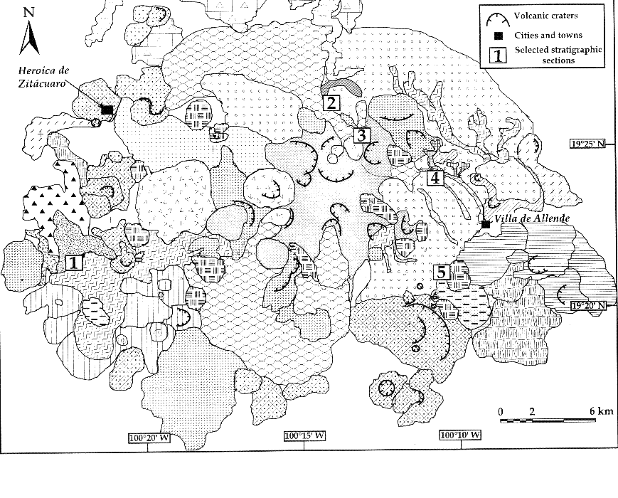
Simplified geological map of the ZVC; the numbers refer to stratigraphic columns shown in fihure. ZVC, located in the Trans-Mexican Volcanic Belt (TMVB), covers about 700 km2. The ZVC has not been systematically studied during this century, but a few geological studies were carried out during the last two decades. A composite geological map (scale 1:25,000), based on the enlarged INEGI 1:50,000 topographic sheets. These studies recognize that the distribution of the volcanic products and collapse features are related to a caldera-like structure. In this paper we present new geological data and we reoevaluate previous results on the volcanological evolution of this complex. We describe the tectonic setting of the ZVC in the geological context of the TMVB and its eruptive history based upon detailed stratigraphic data, chemical and petrographic analyses of selected rocks, and radiocarbon data. It features three tectonic structures marked by lineaments of volcanic edifices and explosion craters. The eastern area is dominated by a NNW-SSE fracture system corresponding to the San Miguel de AllendeуTaxco normal fault system (Demant, 1978), or to the Queretaro fracture zone (Nixon et al., 1987; Garduуo and Gutiйrrez, 1992). This system shows evidence of a Miocene transcurrent component and a reactivation during the Pliocene.The southwestern area includes the Tertiary Tzizio antiform system (Mauvois 1977; Bonassi, 1994; Mennella, 1994; Ferrari et al., 1990); The northern area accommodates an EW fault system related to the Acambay graben of Pleistocene age (Suter et al., 1992). The ZVC contains a large central volcanic complex characterized by several craters with internal domes. The central complex is surrounded by a plain of pyroclastic flows outlined in the distal areas by volcanic cones or by morphological barriers. Other dome structures developed along radial or concentric lineaments. Two remnants of crater rims forming vertical walls are located east and west of the dome complex. A circular "calderaolike" structure is suggested by connecting these rims with the alignment of volcanic cones and the limits of the pyroclastic flow deposits. http://www.geofisica.unam.mx/unid_apoyo/editorial/publicaciones/investigacion/geofisica_internacional/anteriores/1997/03/capra.html |
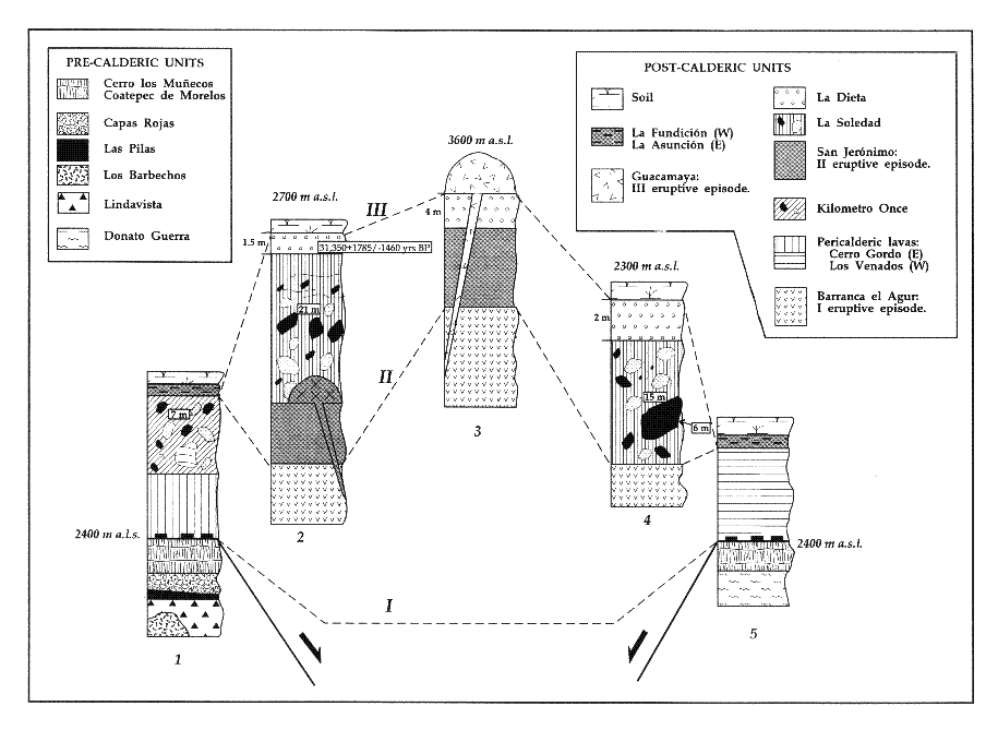
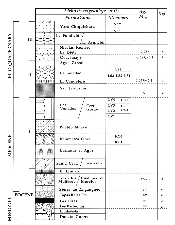
Composite stratigraphic sections of ZVC-Lithostratigraphic units are named after field descriptions, petrography, and chemical characteristics. Modal analyses of selected samples are presented in the following. The percentage values between brackets (vol.%) represent the average modal value of phenocryst phases. The abreviations are as follows: plagioclase (pl), clinopyroxene (cpx), biotite (bt), hornblende (hbl), olivine (ol) and quartz (qz). MesozoicoTertiary basement Upper JurassicуLower Cretaceous The metamorphic basement is composed of low-grade mica schist and calcschist that range in age from Late Jurassic to Early Cretaceous (Israde and Martinez, 1986). This is only exposed in the NNW portion of the area and forms an uplifted block probably associated to NW-SE lineaments. The Lindavista unit overlies discontinuously the metamorphic basement in the western sector of the area. It is composed of andesitic pillow lavas and andesitic lava flows interbedded with volcanoclastic breccias. According to Pasquare et al. (1991), the Lindavista unit has an age of Late JurassicуEarly Cretaceous because it is intruded in the southwestern region by a dioritic body (Los Barbechos unit) dated at 99 Ma (CFE, 1986). Middle-Upper Cretaceous : Las Pilas unit consists of bioclastic fossiliferous-reef limestones. The fossil assemblage has a Tethyan affinity of Albian-Aptian age (Israde and Martinez, 1986). This unit is overlain unconformably by the Capas Rojas Formation, molasses of Eocene-Oligocene age (Islas et al., 1989). Red conglomerates contain decimeterуsize clasts of quartz, limestone, andesite, diorite and metamorphic rocks in sandstone matrix. This formation is described for the first time; previous studies had detected this unit only in the Tuzantla area southwest of the ZVC (Islas et al., 1989). Miocene: The Sierra de Angangueo unit, consisting of basaltic-andesite lava flows and volcaniclastic breccias of Miocene age, is located in a narrow strip in the northern part of the ZVC (Pasquare et al., 1991). This unit represents the marginal part of the Sierra de Angangueo Volcanic Complex located to the north of the ZVC. It has no direct stratigraphic relation to the volcanic units of the ZVC. Upper Miocene: The following units represent the earliest volcanic activity in the ZVC that may be attributed to the TMVB domain (Pasquarй et al., 1991). Actual volcanic vents are not recognizable, but their products are evident.The Coatepec de Morelos unit to the west and the Cerro Los Munecos unit to the east of the studied area feature andesitic lava flows with abundant clinopyroxene phenocrysts (cpx 8у16%). A sample from the Coatepec de Morelos unit yielded a K-Ar age of 12 Ma (CFE, 1986). El Lindero unit represents pyroclastic products of the same volcanic complex. It is composed of well-lithified block-and-ash flow deposits containing andesitic fragments with abundant clinopyroxene and hornblende phenocrysts (cpx 20%, hbl 10%), pumice and cmуsized scoria in a sandy matrix. Pliocene-Quaternary: During the Pliocene-Quaternary, monogenetic cones formed in the west and east sectors of the study area and some dome intruded in its central part. This type of activity was repeated during three distinct episodes, each causing dome resurgence in the central part of the area (Barranca el Agur, San Jeronimo, and Guacamaya units). Around the margins, we find andesitic lava flows (Pueblo Nuevo, Cerro Gordo, Los Venados, La Asuncion, and La Fundiocion units). All these units were grouped in three eruptive episodes according to their stratigraphic position as follows http://www.geofisica.unam.mx/unid_apoyo/editorial/publicaciones/investigacion/geofisica_internacional/anteriores/1997/03/capra.html. |
Zitacuaro. First episode of dome resurgence. The Santiago unit consists of thick (decameter scale) andesitic lava flows with abundant olivine (ol 4.5%). The Santa Cruz unit consists of augiteуbearing andesite lava flows (cpx 12%). Barranca el Agur unit is composed of dacitic dome intrusions forming volcanic edifices about 3000-m high and andesitic lava flows whose vents are not recognizable. Younger pyroclastic flow deposits (Kilomeуtro Once unit) are associated with the Barranca el Agur unit. The rocks from the central domes contain plagioclase, linopyroxene, hornblende and biotite (pl 20%, cpx 4%, hbl 8%, bt 2%). Las Dalias flow deposit (KO1 member) ranges in thickness from 10 to 100 cm; scarce outcrops of this unit did not allow estimation of its areal extent and volume. Las Dalias comprises two flow units: a blockуandуash flow deposit covered by an ash flow deposit. Kilometro Once flow deposit (KO2 member) has a mean thickness of 10 m and covers an area of about 30 km2, yielding a minimum estimated volume of 0.12 km3 (DRE=Dense Rock Equivalent). It is a massive block-and-ash flow deposit, which contains amphibole rich (hbl 12%) dacitic, juvenile clasts with various degrees of vesiculation and rare clasts from the metamorphic basement set in a sandy matrix. Clasts range in size from 2 cm to 1.5 m. In the western sector of the area, two more units were identified: Pueblo Nuevo and Cerro Gordo units. The first is constituted mainly by volcanic cones reaching altitudes of 2700 m (Curungueo, Pueblo Nuevo, Belvedere, El Naranjo, Molcajete, Comunidad, San Lucas). Lithologically, it is composed of andesitic lava flows and two blockуandуash flow deposits with dacitic juvenile lithics. Cerro Gordo unit consists of domes and volcanic edifices that reach up to 2800-m altitude, with their associated andesitic lava flows (cpx 32%, pl 8%). These lava flows can be subdivided into three members according to their stratigraphic position (CG1, CG2, CG3). In the eastern sector, we identify the Los Venados unit, which is characterized by volcanic structures up to 2800уm high composed of andesitic lava flows containing abundant clinopyroxene and olivine (cpx 28%, ol 8%). Based on the location of the vent and their stratigraphic position, these lava flows can be subdivided into four members (LV1, LV2, LV3, LV4). Second episode of dome resurgence : The San Jeronimo unit is located near the central part of the area; it consists of andesitic lava flows and dacitic dome intrusions, some up to 3500-m high. Crater rim scars are still recognizable on these domes. They are probably related to explosive activity that produced significant pyroclastic flow deposits (La Soledad unit). The San Jeronimo products have a paragenesis characterized by plagioclase, quartz, hornblende and biotite (pl 21%, qz 0.7%, hbl 7.5%, bt 0.9%). A K-Ar date of this unit yielded an age of 5 Ma (CFE, 1986). Cerro las Palomas unit, which is exposed in the central part of the area, consists of andesitic lava flows (meters thick) with abundant clinopyroxene phenocrysts (cpx 16%). Eleven endogenic dacitic dome structures as high as 300 m form the El Candelero unit (e.g., Las Flores, Canodelero, Pachuca, Rededonda, Piloncillo, Chato, Chilesdo, Silla). Minor radial lava flows flank these domes. La Soledad unit is subdivided into four members, each one representing a pyroclastic flow deposit. Las Palomas flow (LS1 member) consists of a massive blockуandуash flow deposit (20 m thick) rich in dacitic juvenile clasts 10 cm to 6 m in size. It covers an area of about 40 km2. Due to the scarcity of sections it was not possible to make a volume estimation. La Soledad flow (LS2 member) is composed of three deposits: a pumice flow covered by a block-and-ash flow and an ash flow interbedded with surges at the base. La Soledad flow deposits have a mean thickness of about 22 m; they contain dacitic juvenile clasts in a sandy matrix. This unit extends over an area of about 63 km2 with an estimated volume of 0.4 km3 (DRE=0.3 km3). El Capulin flow (LS3 member) is a block-and-ash flow deposit (mean thickness 15 m) rich in juvenile dacitic clasts. At some outcrops, it can be subdivided into four distinct units. El Capulin flow covers an area of 56 km2 with a minimum volume of 0.3 km3 (DRE=0.2 km3). El Potrero flow (LS4 member) is composed of a basal block-and-ash flow and an ash flow deposit. All these deposits have similar phenocryst assemblages: qz (1%), pl (30%), cpx (1%) hbl (15%) bt (5%) in a glassy matrix with plagioclase microphenocrysts. This unit extends for about 15 km2; however, due to poor outcrops, it was not possible to estimate a volume. The Agua Zarzal unit is characterized by a chaotic epiclastic deposit (2 m thick) rich in rounded quartz, metamorphic and volcanic clasts embedded in a sandy matrix. La Dieta unit is represented by a fall deposit consisting of two main parts separated by a sequence of lapilli-sized horizons. The lower part is clast-supported, inversely graded, pumice-rich (94%), frequently banded with maximum diameters of 7 cm and minor clasts (6%). The upper part is massive, clastуsupported, constituted by 98% in pumice and scoria fragments with maximum diameters of 15 cm and 2% of cm-size lithics. Two charcoal samples from this unit yielded radiocarbon ages of 31,350. B.P. and 30,630 B.P. Third episode of dome resurgence The Guacamaya unit represents the last episode of dome resurgence. It consists of monogenetic dacitic domes, one of which gave a radiometric age of 0.6 Ma (CFE, 1986). The polygenetic dome of Cerro Cacique reaches up to 3300m; it is composed of five dome intrusions with associated autobrecciated lava flows. Petrographically, it is characterized by an enrichment of hornblende crystals (hbl 18%) as compared to the other domes. The Cerro Pelon dome is the only one that produced a pyroclastic flow, here called Nicolas Romero unit, which extends for about 23 km2. This deposit can be subdivided into four flow units consisting of dacitic juvenile clasts with a similar paragenesis to that of the La Soledad unit but with more quartz phenocrysts (15%). Marginal effusive activity in the eastern and western parts of the study area is represented by the Asunciуn and La Fundiciуn units respectively. La Asunciуn unit forms a cone structure with andesitic lava flows while La Fundiciуn unit includes an andesitic lava flow followed by a dome intrusion. Products of these two units feature an enrichment of augitic clinopyroxene phenocrysts (cpx 12%). The youngest volcanic deposits in the ZVC are pyroclastic flow deposits (Vara Chiquichuca unit) represented by two members: VC1, San Francisco crater, and VC2, Hoya de Zitacuaro crater. http://www.geofisica.unam.mx/unid_apoyo/editorial/publicaciones/investigacion/geofisica_internacional/anteriores/1997/03/capra.html |
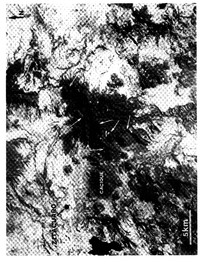
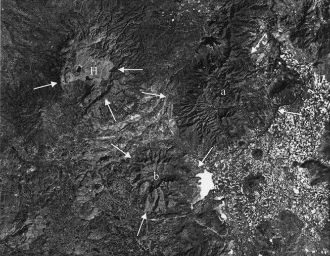
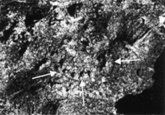
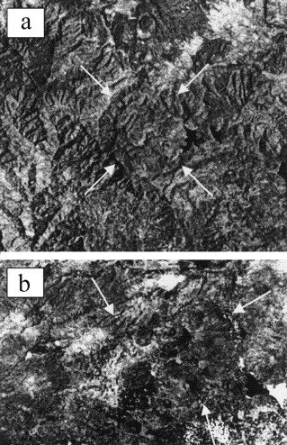
Landsat image of the ZVC. R, the caldera rim remnants. The white arrows indicate the explosion craters of the main resurgent domesMajor (SiO2, TiO2, Al2O3, MnO, CaO, K2O) and trace elements (Sr, Rb, Zr, Y, Nb, La, Ce, Ba) were determined by x-ray fluorescence (Franzini et al., 1972). Na2O and MgO were measured by atomic absorption spectrophotometry, Fe++ by titration, P2O5 by the colorimetric method and loss-on-ignition (LOI) by constant weight heating at 950Ѓ‹ C. CIPW norms were calculated excluding the LOI value. All these analyses were performed at the University of Florence with the assistance of L. Francalanci. The results are shown in Table 1 (from Capra, 1994 and Lafranconi, 1994). Pre-resurgent units: TMVB domain: Pre-resurgent units were described only in terms of their petrographic features. The marginal lavas (western Lindavista and Coatepec de Morelos units, eastern Cerro los Munecos unit) have an andesitic and basalticуandesitic composition. Their anhydrous paragenesis is essentially composed of olivine and pyroxene. The earliest hydrous minerals (hornblende and biotite) appear in the El Lindero pyroclastic flow deposit, which is clearly distinct from the younger flow deposits because of its andesitic composition of juvenile clasts. First eruptive period: Within this episode, two groups with different chemical features can be distinguished. The central intrusive complex (Barranca el Agur unit) and the marginal edifices composed of lava flows (western Pueblo Nuevo and Cerro Gordo units, eastern Los Venados unit). Both have a negative correlation for Al2O3, MgO, FeOTOT and CaO. However for a given SiO2 content, the central intrusive complex has higher Al2O3 values than is common for effusive products and lower abundances of MgO and the other elements. All products feature positive correlations for Na2O, K2O, and Rb; the western lavas show the highest enrichment. Despite slight variations, the chemical characteristics of the Kilometro Once unit are more similar to those of the marginal lava flows. Second eruptive period: This episode can be subdivided into two main groups: The central intrusive complex (San Jeronimo unit), and the juvenile products of the pyroclastic flow deposits (Soledad unit) which originated from this complex. All these rocks have a negative correlation for Al, Ca, Mg, and Fe, while Na, K, and Rb show a positive trend . Pyroclastic flow deposits show larger values for Al, Na, and lower values for Ca, Mg, and Fe elements as compared to the central domes. Third eruptive period: The analyzed rocks have negative trends for Ca, Mg, Fe and Al. The central dome complex (Guacamaya unit) shows relative enrichment in Na, K, and Rb. Collectively, the available data suggest that all the ZVC volcanic products have similar chemical trends in all three eruptive periods. Marginal lava flows have higher contents of Ca, Mg, and Fe elements and a positive correlation in the Na and K diagrams, while pyroclastic deposits and products of the intrusive central activity have larger contents in Al and, generally, a limited variation range in the Harker diagrams. The San Jerуnimo unit (second episode) can be distinguished from the Barranca el Agur unit (first episode) because the latter has a lover content of FeOTOT and is enriched in Al2O3 and Na2O. The Cerro Cacique dome is different from the Guacamaya unit (third episode), because of its low SiO2 and Na2O contents and its higher value of Fe and Al2O3 respect to other domes http://www.geofisica.unam.mx/unid_apoyo/editorial/publicaciones/investigacion/geofisica_internacional/anteriores/1997/03/capra.html. |
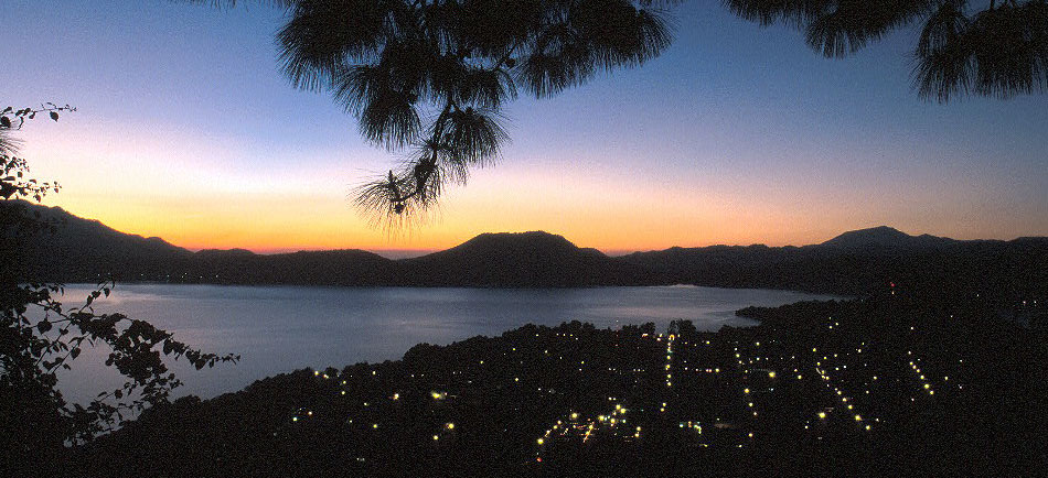
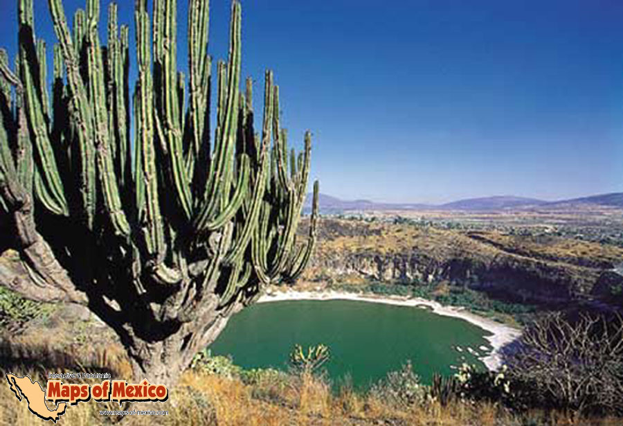
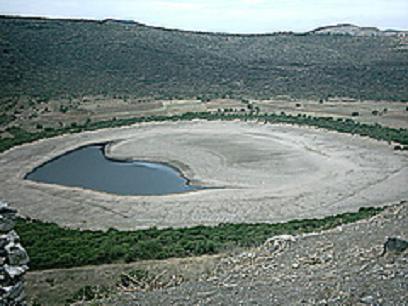
Valle de Bravo |
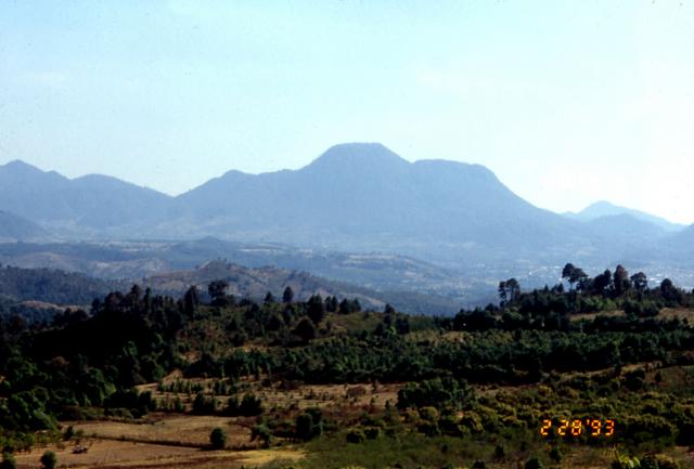
Valle de Bravo. The Zitacuaro-Valle de Bravo, caldera, last eruption 3050 BC Ѓ} 1000 years, summit 3500+ m, volcanic field in the central part of the Mexican Volcanic Belt consists of a broad region of shield volcanoes, lava domes, and cinder cones surrounding the city of Heroica de Zitбcuaro. The Zitбcuaro volcanic complex itself, located SE of the city, was constructed within the 30-km-wide Las Tres Chicas caldera of Miocene age, which later underwent three post-caldera episodes of intra-caldera lava dome resurgence and included the intrusion of dacitic central lava domes, the emplacement of pyroclastic flows, and the eruption of andesitic lava flows. The youngest dated activity at the complex produced La Dieta airfall deposit about 31,000 years ago, and persistent local seismicity continues at Zitacuaro. The Valle de Bravo area to the south contains dominantly andesitic lava domes and flows, many of which were erupted along regional faults. The youngest flows were erupted at the bottom of a fault-controlled canyon; the most recent of these, west of the Valle de Bravo lake, has been Argon-Argon dated at about 5200 +/- 2300 years, and morphology suggests a Holocene age for other cones -.http://www.volcano.si.edu/world/volcano.cfm?vnum=1401-061 http://sk.wikipedia.org/wiki/Zit%C3%A1cuaro-Valle_de_Bravo MAGMATIC EVOLUTION: Pre-resurgent activity generated andesiticуbasaltic anhydrous products with minimal magmatic differentiation, suggesting that these products originated from a single shallow magmatic reservoir. Intrusive and pyroclastic activity during the resurgence period was more differentiated. The Harker diagrams of these rocks suggest that fractional crystallization was the main magmatic process during resurgent activity. The high MgO content for the marginal products as compared with resurgent domes and pyroclastic flows could be explained by assuming two different magma sources with different chemical compositions that fed the resurgent activity at the ZVC. Marginal effusive products can be easily distinguished from central dome intrusions: the evolutionary trends suggest that fractionation of femic minerals prevailed among the marginal lavas while fractionation of plagioclase was more important in the generation of central domes and the pyroclastic flows, which represented the most highly evolved members. Marginal activity generated rapid emissions of poorly differentiated products that tapped magmatic liquids from a deeper level, which rose along tectonically weak zones. The central intrusion domes probably rose from shallower reservoirs where the magma had time to differentiate and to allow magmaуwater interaction, leading to phreatomagmatic activity. The equilibria of mineralogical phases among the various products of the ZVC reflect the pressure and temperature conditions of the magmatic reservoirs. As all resurgent products of the ZVC have a similar magmatic evolution, despite the fact that these magmas were fed by different shallow reservoirs, we infer that they may have been linked by a common deeper magma reservoir. ERUPTIVE HISTORY OF THE ZVC: Walker (1984) proposed to define a resurgent caldera as a volcanic collapse followed by an activity located along radial and circular structures related to caldera formation. Post-resurgent activity is characterized by intrusion of dacitic domes in the central area and by development of andesitic to basaltic lava cones around the caldera rim. Such calderas have been recognized in different parts of the word, including the Long Valley Caldera and the Valles Caldera, California, and the Los Azufres Caldera, Michoacбn, in the Trans Mexican Volcanic Belt (Pradal and Robin, 1985; Ferrari et al., 1991), or the Aguajito Pleistocene caldera in Southern Baja California (Garduсo et al., 1993a). In the latter cases, while morphological features of a caldera structure were lacking, the stratigraphic evidence led the authors to concluded that the dome complex originated from postуcaldera resurgent activity. Miocenic volcanism and the TMVB domain : The earliest volcanic activity at the ZVC began in the Miocene; it features a stratovolcano on a metamorphic and volcano-sedimentary basement of Jurassic-Oligocene age. Its products (Coatepec de Morelos and Cerro Los Muсecos units) have an andesitic and andesiticуbasaltic composition with an anhydrous paragenesis characteristic of poorly evolved magmas. The petrographic analyses of these rocks may suggest the presence of a shallow magmatic source. Caldera collapse: During the Miocene, volcanic activity at ZVC proceeded with the emission of large amounts of andesitic magma emplaced as lavas or pyroclastic flows (El Lindero unit). This activity emptied the upper part of the reservoir causing a partial collapse of its roof and the formation of a caldera structure 30 km in diameter (Las Tres Chicas Caldera). The rim is morphologically expressed in the eastern and western sectors of the study area; elsewhere it is obliterated by pericalderic volcanic edifices. Post-caldera resurgent activity: About 12 MA, post-caldera resurgent activity began at the ZVC. It consisted of three eruptive episodes separated by periods of roughly 5 Ma. Evolved magma of andesitic-dacitic composition was extruded. As it rose, the magma was stored in different reservoirs in an environment of high water content. From the chemistry and the modal analyses of these products it is likely that fractional crystallization dominated in these reservoirs. Different chemical and petrological variations observed among products of these three eruptive episodes suggest that these reservoirs evolved under different specific conditions. First resurgent episode:Barranca el Agur unit, which represents the first resurgent phase, occurred about 12 Ma ago. Its products are andesitic (SiO2=59%) to dacitic (SiO2=63%), the latter representing the central dome complex. Later during this episode, this dome complex gave rise to explosive activity that produced blockуandуash flow deposits (Kilometro Once unit). Andesitic lava flows were extruded in the nearуcaldera areas (Pueblo Nuevo, Cerro Gordo and Los Venados units), from radial fractures related to the caldera structure. Second resurgent episode: The second episode began approximately 5 Ma ago with a dacitic intrusion which emplaced a series of domes in the central area (San Jeronimo unit). These domes filled the crater formed during the first period of activity. Monogenetic intrusions (El Candelero unit) of dacitic composition were emplaced along radial structures. Pyroclastic activity was restricted to the resurgent central complex (San Jerуnimo unit), and generated block-and-ash flow deposits (La Soledad unit). These flows were not able to overtop the caldera rim but they partly filled the caldera depression (Figure 3). The La Dieta fallout unit, only 31,000 yr. ago, suggests that this episode of resurgent activity coexisted with the most recent one. Third resurgent episode: The latest resurgent period occurred about 0.5 Ma ago and produced the Guacamaya unit. It is characterized by dome intrusions of dacitic composition within explosion craters formed during the second eruptive episode. The intrusions fed andesitic lava flows in near-caldera areas (La Asunciуn and La Fundicion units). This activity ended with the emplacement of the Nicolas Romero block-and-ash flow deposit originating from Cerro Pelуn dome. The last activity related to the caldera structure was hydromagmatic, along NNW-SSE tectonic structures http://www.geofisica.unam.mx/unid_apoyo/editorial/publicaciones/investigacion/geofisica_internacional/anteriores/1997/03/capra.html. |
Zitacuaro-Valle de Bravo. Las Tres Chicas caldera is 30 km wide. The volcano covers and area of 3700 sq km and contains 120 cinder cones, one shield volcano, seven lava domes, and two lava dome complexes. Zitacuaro-Valle de Bravo is one of four monogenetic volcanic fields in the central sector of the Mexican Volcanic Belt. It is located at the southern front of the belt, where is covers the western flank of Nevado de Toluca volcano. http://www.volcanolive.com/bravo2.html Zitacuaro-Valle de Bravo volcano is a volcanic field in the central part of the Mexican Volcanic Belt 80 km SW of Mexico City. It consists of the Zitacuaro complex which formed above the giant, 30 km wide Las Tres Chicas caldera near city of Heroica de Zitбcuaro, and the Valle de Bravo field to the south. The field contains andesitic lava shields, lava domes, and more than 100 cinder cones. The last activity was west of the Valle de Bravo lake. The Las Tres Chicas caldera is of Miocene age and would be classified as the result of a super-volcano eruption. The Zitбcuaro complex is the result of activity within the caldera, which occurred during 3 principal episodes, forming dacitic lava domes, pyroclastic flows and andesitic lava flows. The youngest dated activity at the Zitбcuaro complex produced the La Dieta airfall deposit about 31,000 years ago. Persistent local seismicity continues at Zitacuaro. The Valle de Bravo area is located to the south. It contains dominantly andesitic lava domes and flows, many of which were erupted along regional faults. The youngest flows were erupted at the bottom of a fault-controlled canyon; the most recent of these, west of the Valle de Bravo lake, has been Argon-Argon dated at about 5200 +/- 2300 years ago, and its morphology suggests a Holocene age for other cones. http://www.volcanodiscovery.com/zitacuaro.html An Upper-Miocene caldera structure has been recognized and mapped in the ZVC. We name this structure the "Las Tres Chicas Caldera". Postуcaldera activity at Las Tres Chicas took place in three different resurgent episodes beginning about 12 Ma ago with quiet intervals of ca. 5 Ma. Each episode was characterized by intracaldera dacitic intrusions followed by a pyroclastic phase with simultaneous andesitic effusive activity in the nearуcaldera area. Eruptive products belong to the calcуalkaline series, as is commonly observed in the TMVB. The chemistry of the rocks suggests that the resurgent activity was fed from different shallow reservoirs which were probably derived from a common deeper magma chamber. The periodicity of the resurgent activity at the ZVC may pose potential volcanic hazards for the surrounding areas, including the city of Herуica de Zitacuaro (population of circa 70,000). This city is located 3 km from Cerro Cacique dome which belongs to the youngest episode of major volcanic activity. Relatively recent volcanic activity is represented by the La Dieta fall unit (circa 31,000 yr. B.P., present work). The periodicity of the volcanic activity and the fact that inhabitants of the city of Zitбcuaro have reported frequent local seismic activity during this century contribute to suggesting that the ZVC should be considered as a potentially active volcanic zone - http://www.geofisica.unam.mx/unid_apoyo/editorial/publicaciones/investigacion/geofisica_internacional/anteriores/1997/03/capra.html. |
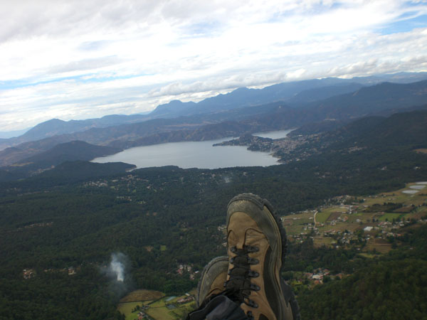
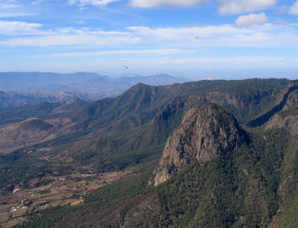
The Penon in Valle De Bravo.Arc Mantle Xenoliths and Their Quaternary Andesite Host Rocks Near El Penon, Central Trans Mexican Volcanic Belt:a Trace Element and Radiogenic Isotope Study. Hydrous ultramafic xenoliths and cpx megacrysts from a Quaternary hbl andesite erupted along a fault escarpment near El Penon in the Central Trans Mexican Volcanic Belt provide a rare glimpse into the upper mantle beneath an active continental Trace Element and Radiogenic Isotope Study. Hydrous ultramafic xenoliths and cpx megacrysts from a Quaternary hbl andesite erupted along a fault escarpment near El Penon in the Central Trans Mexican Volcanic Belt provide a rare glimpse into the upper mantle beneath an active continental arc. These materials represent lithospheric mantle affected by the Oligocene to Early Miocene subduction of the Farallon Plate, and by the Middle Miocene to Recent subduction of the Cocos Plate, both beneath the North American Plate. Composed of amph-rich spinel lherzolite and Cr-oliv websterite, the xenoliths are among the most oxidized mantle peridotites yet described (Dlog FMQ +1.5 to +2.4) (Blatter and Carmichael,1998). The mineralogy of the spinel lherzolites indicates that the rocks are residues of mantle melting while that of the Croliv websterites suggests a cumulate origin. Although devoid of veins and dikes except at the contacts with the host andesites, these xenoliths exhibit ample evidence for metasomatism, including the occurrence of multiple generations of amph. We report trace element concentrations and radiogenic isotopic compositions for the host andesites, peridotite xenoliths and cpx megacrysts determined by a variety of methods. PM-normalized trace element abundances for fifteen lavas show remarkable uniformity (with La n/Ybn = 5.6-12.7) in spite of their large ranges in SiO2 (52.05-63.50 wt%) and MgO (2.80-8.86 wt%). The one exception is the sample with the lowest SiO2, which has greater enrichments in the LREE and MREE as well as in Ba, Th, and U relative to the rest of the samples. All of the lavas analyzed exhibit negative anomalies for the HFS elements Nb, Ta and Hf, typical of arc magmas. REE abundances for the cpx and amph in the peridotites cover a wide range, especially for the LREE. The patterns have a variety of shapes indicative of depletion and enrichment, attesting to the complexity of the mantle wedge above subduction zones. In some hydrous samples, both amph and cpx are highly depleted in the LREE (Lan/Smn = 0.10-0.21), which suggests that this is an early-generation amph that is actually residual after melt extraction. Yet in others, a convex pattern with the MREE higher than the LREE and HREE is conspicuous. In one sample, cpx displays a flat pattern at 4-5x chondrite, except for Nd which has a small negative anomaly. The corresponding amph abundances have overall abundances of >10x chondrite and a dissimilar convex pattern. It therefore appears that the inflection at Nd for the cpx pattern was caused by metasomatism. Of the two cpx megacrysts analyzed, one has LREE-enriched patterns that show no significant variation between the core and rim. The other has a convex REE pattern for the core and an LREE-enriched pattern for the rim. This feature suggests reaction between the megacryst and the host lavas. Similar non-equilibrium between cores and rims has been observed for some of the cpx grains in the peridotites. The cpx rims in this case have patterns and absolute abundances similar to those of the lava phenocrysts. Overall, the convex pattern is dominant in the peridotite cpx grains. This pattern most likely developed by local, subduction-related metasomatism followed by some melting. The isotopic compositions of Sr, Nd and Pb have been determined for five of the host lavas and the two cpx megacrysts; the peridotite xenoliths are not big enough to allow isotopic eterminations by conventional TIMS methods. The host lavas have 87Sr/86Sr values with a range of 0.703376 - 0.704435and 143Nd/144Nd of 0.512824 - 0.512915. On Pb covariation diagrams, the host rocks fall in the Pacific MORB field for 208Pb/204Pb vs. 206Pb/204Pb, but are slightly above it for 207Pb/204Pb vs. 206Pb/204Pb. These values are very similar to those of the cpx megacrysts we have analyzed and to those of western Mexico volcanoes (Wallace and Carmichael, 1994) in the same arc. It does not appear from these results that components from subducted sediments are well represented in either the host lavas or the reacted cpx megacryst. However, the Pb isotopes display a time-integrated record of high U/Th requiring sufficient time for the in growth of U-derived radiogenic Pb isotopes. This feature may have been acquired by the ageing of metasomatized mantle wedge prior to its fragmentation and transportation to the surface from the zone of melting beneath the arc. Blatter DL & Carmichael ISE, Geology, 26, 1035-1038, (1998). Wallace PJ & Carmichael ISE, Contrib. Mineral. Petrol., 117, 345-361, (1994). http://www.the-conference.com/JConfAbs/5/729.pdf Cinder Cone Volcano approximately 10 kms in front of El Penon launch in Valle de Bravo |
El Penon. Mantle peridotite xenoliths in andesite lava at El Penon, central Mexican Volcanic Belt.. Peridotites in the mantle wedge and components added to them from the subducting slab are thought to be the source of most arc magmas. However, direct sampling of these materials, which provides a glimpse into the upper mantle beneath an active margin, is exceedingly rare. In the few arc localities where found, peridotite xenoliths are usually brought to the surface by basaltic magmas. Remarkably, the hornblende-bearing ultramafic xenoliths and clinopyroxene megaxenocrysts from El Peсon in the central Mexican Volcanic Belt were brought to the surface by a Quaternary high-Mg siliceous andesite, a rock type usually considered too evolved to be a direct product of mantle melting. The xenoliths and megaxenocrysts from El Peсon represent lithospheric mantle affected by significant subduction of oceanic lithosphere since as early as the Permian. Trace element and radiogenic isotope data we report here on these materials suggest a history of depletion by melt extraction, metasomatism involving a fluid phase, and finally, limited reaction between the ultramafic materials and the host andesite, probably during transport. They also show that high-Mg siliceous andesite can be a direct product of 1–5% melting of H2O-bearing spinel lherzolite. Keywords: peridotite xenoliths; arc settings; andesite; metasomatism http://www.geo.mtu.edu/EHaz/ConvergentPlatesClass/el%20penon/mukasa%20peridotite.pdf |
The siliciclastic deposit overlying the Mendez Formation at El Penon I in northeastern Mexico (author GK for scale). Unit 1 consists of two altered vesicular glass (microtektites and microkrystites) spherule layers with abundant reworked clastics and shallow water foraminifera. Spherules average 1 mm in diameter (A). A 10–20-cm-thick sandy limestone separates these two spherule layers. Sandstone unit 2 disconformably overlies unit 1. J-shaped burrows (5–10 cm long) infilled with spherules from the underlying unit 1 sherule layer and truncated at the top are found near the base of unit 2 (B). These burrows indicate colonization of the ocean floor during deposition of the sand unit 2 and negate rapid deposition by an impact-generated tsunami. (b) El Penon II, about 300 m from El Penon. The siliciclastic deposit with the altered vesicular impact glass spherule layer of unit 1, the sandstone unit 2 and alternating sand, silt and shale layers of unit 3 that form the top of the outcrop mesas in the area. Bioturbation and trace fossils are relatively rare in unit 2 (see B), but common to abundant in the fine-grained layers of unit 3. Chondrites burrows seen as vertical shafts in fine-grained silt layers (B) or exposed on bedding planes (A) are abundant. These burrows indicate repeated colonization of the ocean floor during deposition of unit 3 and negate rapid deposition by an impact-generated tsunami.The stratigraphy and age of altered impact glass (microtektites, microkrystites) ejecta layers from the Chicxulub crater are documented in Late Maastrichtian and Early Danian sediments in Mexico, Guatemala, Belize and Haiti. In northeastern Mexico, two to four ejecta layers are present in zone CF1, which spans the last 300 ky of the Maastrichtian. The oldest ejecta layer is dated at 65.27Ѓ}0.03 Ma based on sediment accumulation rates and extrapolated magnetostratigraphy. All younger ejecta layers from the Maastrichtian and Early Danian Parvularugoglobigerina eugubina zone Pla(l) may represent repeated episodes of reworking of the oldest layer at times of sea level changes and tectonic activity. The K/T boundary impact event (65.0 Ma) is not well represented in this area due to widespread erosion. An Early Danian Pla(l) Ir anomaly is present in five localities (Bochil, Actela, Coxquihui, Trinitaria and Haiti) and is tentatively identified as a third impact event at about 64.9 Ma. A multiimpact scenario is most consistent with the impact ejecta evidence. The first impact is associated with major Deccan volcanism and likely contributed to the rapid global warming of 3–4 Ѓ‹C in intermediate waters between 65.4 and 65.2 Ma, decrease in primary productivity and onset of terminal decline in planktic foraminiferal populations. The K/T boundary impact marks a major drop in primary productivity and the extinction of all tropical and subtropical species. The Early Danian impact may have contributed to the delayed recovery in productivity and evolutionary diversity.Multiple impacts across the Cretaceous–Tertiary boundary- http://www.sciencedirect.com/science/article/pii/S0012825202001629 |
Panoramic view to the northeast of the Malinalco graben |
Crater Valle de Santiago, TMVB |
Crater Valle de Santiago, TMVB |
Crater Valle de Santiago, TMVB. In Valle de Santiago you can see several extinguished volcanoes whose craters are beautiful lakes such as: La Alberca famous for its sulphur waters , La Hoya de Cintura characterized for its thermal waters with healing qualities, La Hoya de las Flores where you can see vestiges of a Pre Hispanic ceremonial town, rupestrian paintings and some springs.La Alberca |
La Hoya de Cintura TMVB |
Nevado de Colima |
Colima Volcano |
Geothermal activities at Los Azufres caldera, TMVB.Geology of Los Azufres caldera, Mexico, and its relationships with regional tectonics. The Los Azufres geothermal field is one of several silicic centres of the Mexican Volcanic Belt (MVB) for which a caldera structure was suggested. Geological and structural surveys in a wide area surrounding Los Azufres reveal that this complex is situated in an area of unusual concentration of acid volcanism, consisting of four pyroclastic units and several dome complexes. Although a complete caldera structure is not morphologically evident, several facts suggest a long collapse history at Los A zufres:- the geothermal field lies at the centre of a subcircular depressed area (27 Ч 26 km in size) filled by a distinctive fluviolaeustrine sequence:- Middle to Late Miocene rocks bound to the south and to the north of this depression and are encountered only at depth inside it;- four large ignimbritic suites of latest Miocene and Pliocenc age outcrop outside the depression;- volume estimations of these pyroclastic products are comparable with the missing volume of the depressed area:- no alternative caldera structures exist in a radius of 200 km from Los Azufres;- dacitic to rhyolitic lavas, principally extruded as dome complexes, were emplaced inside this depression during the Pleistocene.Los Azufres is therefore interpreted as a nested caldera of latest Miocene and Pliocene age,The recent regional tectonic evolution of the central sector of MVB comprises a Late Miocene-Early Pliocene left-lateral transcurrent phase, followed by a Late Pliocene-Quaternary transtensional one. The silicic volcanism occurring between 6.1 and 2.8 Ma can be linked to the first phase, while in the adjacent areas of MVB a volcanic hiatus can be recognized.The following transtensional phase reached the Los Azufres area only during the Pleistocene and disrupted the caldera structure. Normal faults, developed during this period, controlled the uprising of basic magma which partly interacted with the remaining differentiated one and produced part of the recent intracaldera cycle. http://www.geo.mtu.edu/EHaz/ConvergentPlatesClass/Los%20Azufres/Ferrari1991.pdf |
Geological sketch map of the Los Azufres volcanic complex. For clarity, domes from the Ucareo (We), Pueblo Viejo(PV), San Pedro Jacuaro (SPJ) and Cieneguillas (CI) sequences of rhyolites have not been depicted. AC=Acambaro ignimbrites; SPJ=San Pedro Jacuaro village. Solid stars refer to studied outcrops from the Tarandacuao (TA) sequence sections Fand G are located about 35 km east of the caldera).Long-lived magmatic phases at Los Azufres volcanic center, Mexico The Los Azufres volcanic complex has had a long eruptive history of 1.5 Myr or more (less than 3 Myr),subsequent to the building of a large Miocene and Pliocene andesitic complex. Since about 1.5 Ma, its development consists of two main periods of volcanic activity. The first period, from 1.5 to 0.8 Ma, had two magmatic cycles, about 200,000 years in duration, characterized by acidic, followed basaltic volcanism. Such a magmatic evolution suggests successive emptyings of a shallow reservoir in which differentiation previously occurred.About 0.6 Ma, major deep magma supplies were probably responsible for the resurgent doming which led to uplift of the southern part of the caldera. From 0.6 Ma to Present, the second period exposes volcanic products grading from basalts to rhyolites. Considering the recent age of the last ignimbrites (26,000 to 29,000 years), one can assume that the volcanic activity related to a voluminous differentiated magma body at shallow depth has not yet ended, especially in the southern area, in and around the resurgent zone occupied by the geothermal field. http://horizon.documentation.ird.fr/exl-doc/pleins_textes/pleins_textes_6/b_fdi_35-36/42466.pdf |
Examples of features apparently connected with satellite lineations. a, the Amealco caldera (about 10 km diameter, Landsat image 49, coordinates 20��08��N, 100��09��W; feature #100 reliability: Good, cut by the Epitcaio Huerta fault identified EH-F); and b, c, two other semicircular features cut by a fault (identified AGS-F) belonging to the Acambay graben system. North is up. Arrows point the borders of the features http://www.sciencedirect.com/science/article/pii/S0377027300002973 http://www.geociencias.unam.mx/~ger/2000_GSASP_334_Ame.pdf |
The Mazahua caldera (approximately 8 km diameter),identified first on the basis of this Landsat image (image 41, coordinates 19o37ЃfN, 100o00ЃfW; feature #105). North is up. Arrows highlight the caldera rim.Circular features in the Trans-Mexican Volcanic Belt. One hundred and ninety-one circular or elliptical features have been located on Landsat imagery of the Trans-Mexican Volcanic Belt (TMVB). The origin of most of these features is unknown. Nine have been recognized as collapse calderas (clearly visible on Landsat imagery) and studied in detail, while an equally small number have been tentatively identified as such but not thoroughly investigated. On the basis of the identification of at least five of the nine calderas through their detection on Landsat images, it is proposed that the present inventory is a reliable base to extend the census of the TMVB confirmed calderas, now clearly too small for a population of roughly 8000 volcanic centers, many of which emitted large volumes of felsic pyroclastic products. http://www.sciencedirect.com/science/article/pii/S0377027300002973 |
The centers of the features a, b, (Landsat image 41, respective coordinates 20o11ЃfN, 99o26ЃfW; feature #122; reliability: Good, and 20o17ЃfN, 99o13ЃfW; feature #129ty: Good) appear occupied by volcanic constructs, possible resurgent edifices. H is the Huichapan caldera (about 8„X10 km diameter). North is up. Arrows point the borders of the features http://www.sciencedirect.com/science/article/pii/S0377027300002973 |
This elliptical feature (about 5Ѓ~9 km diameter, Landsat image 58, coordinates 19o38.8ЃfN, 101o44.2ЃЊЃf; feature #52;: Fair) is partially circled by lava domes, possible evidence for its relation with a once active magma chamber. North is up. Arrows point the border of the feature. http://www.sciencedirect.com/science/article/pii/S0377027300002973 |
Examples of circular (a, Landsat image 58, coordinates 19oЃ‹18.3ЃЊN, 101Ѓ‹32.8ЃЊW, about 7 km diameter, feature #62; reliability: Good) and elliptical (b, Landsat image 49, coordinates 20Ѓ‹01ЃЊN, 101Ѓ‹36.5ЃЊW; about 20Ѓ~30 km diameter; feature #159 in; reliability: Poor) features. North is up. Arrows point the borders of the features http://www.sciencedirect.com/science/article/pii/S0377027300002973 |
LT Los Tuxtlas volcanic field. Further constraints for the Plio-Pleistocene geomagnetic field strength:New results from the Los Tuxtlas volcanic field (Mexico) A rock-magnetic, paleomagnetic and paleointensity study was carried out on 13 Plio-Pleistocene volcanic flows from the Los Tuxtlas volcanic field (Trans Mexican Volcanic Belt) in order to obtain some decisive constraints for the geomagnetic field strength during the Plio-Pleistocene time. The age of the volcanic units, which yielded reliable paleointensity estimates, lies between 2.2 and 0.8 Ma according to the available K/Ar radiometric data. Thermomagnetic investigations reveal that remanence is carried in most cases by Ti-poor titanomagnetite, resulting from oxyexsolution that probably occurred during the initial flow cooling. Unblocking temperature spectra and relatively high coercivity point to �small� pseudo-single domain magnetic grains for these (titano)magnetites. Single-component, linear demagnetization plots were observed in most cases. Six flows yield reverse polarity agnetization,five flows are normally magnetized, and one flow shows intermediate polarity magnetization. Evidence of a strong lightning-produced magnetization overprint was detected for one site. The mean pole position obtained in the corresponding mean paleodirection , which is not significantly different from the expected direction estimated from the North American apparent polar wander path. Thirty-nine samples were pre-selected for Thellier palaeointensity experiments because of their stable remanent magnetization and relatively weak-within-site dispersion.Only 21 samples, coming from four individual basaltic lava flows, yielded reliable paleointensity estimates with the flow-mean virtual dipole moments (VDM) ranging from 6.4 to 9.1 x 10 step22 Am2. Combining the coeval Mexican data with the available comparable quality Pliocene paleointensity results yield a mean VDM of 6.4x10step22 Am2, which is almost 80% of the present geomagnetic axial dipole. Reliable paleointensity results for the last 5 Ma are still scarce and are of dissimilar quality. Additional high-quality absolute intensity determinations are needed to better constraint the geomagnetic field strength during the Plio-Pleistocene time. http://svr4.terrapub.co.jp/journals/EPS/pdf/2001/5309/53090873.pdf |
Tectonic sketch map of the TMVB, with the locations of detected features shown with symbols: circles (58%) for features less than 10 km across, triangles (29%) for features between 10 and 20 km across, and stars (13%) for features larger than 20 km across. Verified calderas are: SM, Santa Marı́a del Oro; LP, La Primavera; LA, Los Azufres; A, Amealco; M, Mazahua; H, Huichapan; Ac, Acoculco; LH, Los Humeros; Ch, Chiconquiaco. Major tectonic elements are: 1, Jalisco block; 2, Colima graben; 3, Michoacan block; 4–4′, Pénjamo graben; 5, Tzitzio anticline; 6–6′, Querétaro-Taxco fracture zone; 7–7′, Chapala-Tula fracture zone - http://www.sciencedirect.com/science/article/pii/S0377027300002973 |
Sketch map of the TMVB showing the location of the volcanoes with known sector collapse: Colima Volcanic Complex (CVC), Milpilla (Mi), Patamban (Pa), Estribo (Es), Tancı́taro (Ta); Zirahuato (Zi), Jocotitlan (Jo), Nevado de Toluca (NT), Zempoala (Ze), Ajusco (Aj), Iztaccihuatl (Iz), Popocatepetl (Po), Cerro Las Navajas (CN), Las Derrumbadas (De), Pico de Orizaba (PdO), Las Cumbres (LC), and Cofre de Perote (CdP). Santa Martha (StM), San Martin Pajapan (SMP) and Los Tuxtlas Volcanic Field (TVF) not in the TMVB are also shown.Volcanoes of the Trans-Mexican Volcanic Belt (TMVB) have yielded numerous sector and flank collapses during Pleistocene and Holocene times. Sector collapses associated with magmatic activity have yielded debris avalanches with generally limited runout extent (e.g. Popocatepetl, Jocotitlan, and Colima volcanoes). In contrast, flank collapses (smaller failures not involving the volcano summit), both associated and unassociated with magmatic activity and correlating with intense hydrothermal alteration in ice-capped volcanoes, commonly have yielded highly mobile cohesive debris flows (e.g. Pico de Orizaba and Nevado de Toluca volcanoes). Collapse orientation in the TMVB is preferentially to the south and northeast, probably reflecting the tectonic regime of active E�W and NNW faults. The differing mobilities of the flows transformed from collapses have important implications for hazard assessment. Both sector and flank collapse can yield highly mobile debris flows, but this transformation is more common in the cases of the smaller failures. High mobility is related to factors such as water content and clay content of the failed material, the paleotopography, and the extent of entrainment of sediment during flow (bulking). The ratio of fall height to runout distance commonly used for hazard zonation of debris avalanches is not valid for debris flows, which are more effectively modeled with the relation inundated area to failure or flow volume coupled with the topography of the inundated area http://www.sciencedirect.com/science/article/pii/S0377027301002529 |
The cohesive Naranjo debris-flow deposit (10 km3): A dam breakout flow derived from the Pleistocene debris-avalanche deposit of Nevado de Colima Volcano http://www.sciencedirect.com/science/article/pii/S0377027302002457 |
The Trans-Mexican Volcanic Belt (TMVB) is a 1000 km long Neogene continental arc showing a large variation in composition and volcanic style, and an intra-arc extensional tectonics. It overlies the Rivera and Cocos slabs, which display marked changes in geometry. Geophysical studies indicate that lithospheric mantle is very thin or absent beneath the forearc and arc, the fluids from the slab are released in a 40 to 100 km wide belt beneath the frontal part of the arc, and the lower crust beneath the arc is partially molten. East of 101Ѓ‹W the TMVB is built on a Precambrian to Paleozoic crust with thickness of 50-55 km. West of 101Ѓ‹W the TMVB is underlain by Jurassic to Cenozoic marine and continental arcs with a 35-40 km thick crust. The evolution of the TMVB occurred in four stages: 1) from ~20 to 10 Ma the initial andesitic arc moved inland showing progressively drier melting and, eventually, slab melting, suggesting flattening of the subducted slab; 2) since ~11 Ma a pulse of mafic volcanism migrated from west to east reaching the Gulf of Mexico by 7 Ma. This mafic lavas marks the lateral propagation of a slab tear, triggered by cessation of subduction beneath Baja California. 3) thereafter, the volcanic front started moving trenchward, with a marked phase of silicic volcanism between 7.5 and 3 Ma, local emplacement of small volume intraplate-like basalts since 5 Ma, and development of extensional faulting. These features are related to slab rollback, enhancing asthenophere flux into the mantle wedge and promoting partial melting of the crust; 4) the modern arc consists of a frontal belt dominated by flux and slab melting, and a rear belt characterized by more differentiated rocks or by mafic lavas with little or no evidence of subduction fluids but higher asthenosphere fingerprint http://www.geociencias.unam.mx/geodinamica/research/research/mexico/tmvb/tmvb2.php
http://www.volcano.si.edu/index.cfm cerro negro Nicaragua
http://ajourneythroughguatemala.blogspot.com/2010/05/volcano-hiking-in-quetzaltenango.html guatemala
http://climber.org/reports/2001/741.html baja
http://en.wikipedia.org/wiki/Mountain_peaks_of_Mexico
http://www.volcanolive.com/mexico.html
http://en.wikipedia.org/wiki/List_of_volcanoes_in_Mexico list of volcanoes
http://en.wikipedia.org/wiki/List_of_volcanoes_in_Mexico
http://en.wikipedia.org/wiki/Category:Volcanism_of_Mexico
http://www.volcanolive.com/mexico.html
[http://www.volcano.si.edu/world/volcano.cfm?vnum=1401-007 baja
http://dbarker.perso.neuf.fr/Mytravels/Mexico/All%20Mexico%202.html photos
LTVF = Los Tuxtlas volcanic field.
________________________________________
Zitacuaro-Valle de Bravo tmvb
http://en.wikipedia.org/wiki/List_of_volcanoes_in_Mexico
Two black boxes outline the Zitacuaro- Valle de Bravo (ZVB)
MGVF-Michoakan – Guanajuato Volcanic Field, VBZ -Valle de Bravo El Penon flow
http://www.volcano.si.edu/world/volcano.cfm?vnum=1401-061 Zitбcuaro-Valle de Bravo Volcano http://www.volcanolive.com/bravo2.html
http://www.volcanolive.com/papayo.html - Papayo Volcano
http://www.volcanolive.com/serdan.html Serdбn-Oriental Volcano
http://www.volcanolive.com/atlixcos.html Los Atlixcos Volcano
http://www.volcanolive.com/humeros.html
http://www.volcanolive.com/naolinco.html Naolinco Volcano
http://www.volcanolive.com/gloria.html la gloria
http://www.volcanolive.com/cumbres.html Las Cumbres
La Malunche - 19.23 N, 98.03 W
summit elevation 4503 m
Stratovolcano
La Malinche volcano is located 110 km SE of Mexico City, in
the eastern central part of the Trans-Mexican Volcanic Belt.
The volcano contains a several dacitic domes at the summit and lacks a summit crater. A small parasitic crater (Atitlan) is situated on La Malinche''''s western flank, and a larger and more eroded crater is located on the eastern flank, near the summit.
La Malinche is strongly eroded and last erupted about 3100 years ago. Partial sector collapse occurred at the volcano 21,000 years ago.
Eruptions at La Malinche Volcano
Eruptions at La Malinche volcano consist of plinian eruptions which last days to weeks, followed by longer intermittent episodes of pyroclastic flow activity caused by dome collapse.
La Malinche Volcano Eruptions
3100 years ago.
http://www.volcanolive.com/mexico.html baja
http://en.wikipedia.org/wiki/List_of_volcanoes_in_Mexico
http://en.wikipedia.org/wiki/Category:Volcanism_of_Mexico
http://en.wikipedia.org/wiki/Volcanoes_of_east-central_Baja_California
http://en.wikipedia.org/wiki/List_of_volcanoes_in_Mexico
http://en.wikipedia.org/wiki/Category:Volcanism_of_Mexico
http://en.wikipedia.org/wiki/Baja_California_peninsula
http://www.csus.edu/indiv/h/hausback/PDFs%20of%20Publications/Hausback%201984%20Cenozoic%20Volcanic%20and%20Tectonic%20Evolution%20-%20Baja.pdf - Cenozioc Volcanos and tectonic evolution of Baja california sur, Mexico
http://www.volcanodiscovery.com/baja-california.html
http://www.volcanolive.com/mexico.html
http://www.volcanodiscovery.com/baja-california.html
See - http://sciencythoughts.blogspot.co.uk/2012/01/ubehebe-crater-seventh-potentially.html Ubehebe Crater; a seventh potentially active volcano in California
http://sciencythoughts.blogspot.co.uk/2012/02/mapping-subductioin-zone-beneath-taiwan.html Mapping the subductioin zone beneath Taiwan
http://sciencythoughts.blogspot.com/2012/03/understanding-subduction-zone-beneath.html journal
TA = Tzitzio Anticline, NT = Nevado de Toluca, DF = Distrito Federal, G = Guadalajara, IZ = Ixtapa Zihuantanejo, C = Nevado de Colima, and Ce = Ceboruco. Note the association of the Tzitzio Gap with the subduction trajectory of the OFZ. LA = Los Azufres caldera, A = Amealco caldera, H = Huichipan caldera, TA = Tzitzio Anticline, Zr = Zirahuato domes, NT = Volcan Nevado de Toluca, M = Morelia, PG = Penajamillo Graben, CG = Cuitzeo Graben, TQ = Taxco-Queretaro fault system, and AG = Amealco Graben
Blatter DL & Carmichael ISE, Geology, 26, 1035-1038, (1998). Wallace PJ & Carmichael ISE, Contrib. Mineral. Petrol., 117, 345-361, (1994). http://www.the-conference.com/JConfAbs/5/729.pdf
http://en.wikipedia.org/wiki/Cheam_Peak canadian cascades
TMVB - grabens
List of Volcanoes
Trans Mexican Volcanic Belt -Review
The Zitacuaro Volcanic Complex,magmatic and eruptive history of a resurgent caldera
Nature
