 |
Prior to this study, EW oriented faults of the MoreliaAcambay system where thought to have been originated around 56 Ma (Israde, 1995). Lie fiend that this fault dates from ~8 Ma and that some segments were reactivated during the Pleistocene including the QuerendaroIndaparapeo segment (<700 ka), the Cointzio and Huiramba segments (<500 ka), the Pбtzcuaro segment (<30 ka and during historic times), the Tarнmbaro segment (<3.6 ka), La Paloma segment (twice after 1.6 ka with displacements of ca. 80 cm), and the Charo segment (during the Holocene). These results suggest that the region is prone to shallow intraplate seismicity. Known historic earthquakes have occurred at the eastern tip of the MAFS affecting areas from Los Azufres geothermal field to the Acambay region (Suter et al., 1996). Population in the western edge of MAFS has increased over the past decades to 1.5 million including Morelia, Patzcuaro, Zinapecuaro and smaller towns. Renewed seismic activity in the region poses a serious threat to this population. Paleoseismicity studies in the region of Morelia and Patzcuaro may improve the estimates of recurrence of earthquakes and displacement along these faults, in order to assess the hazard. |
|
|
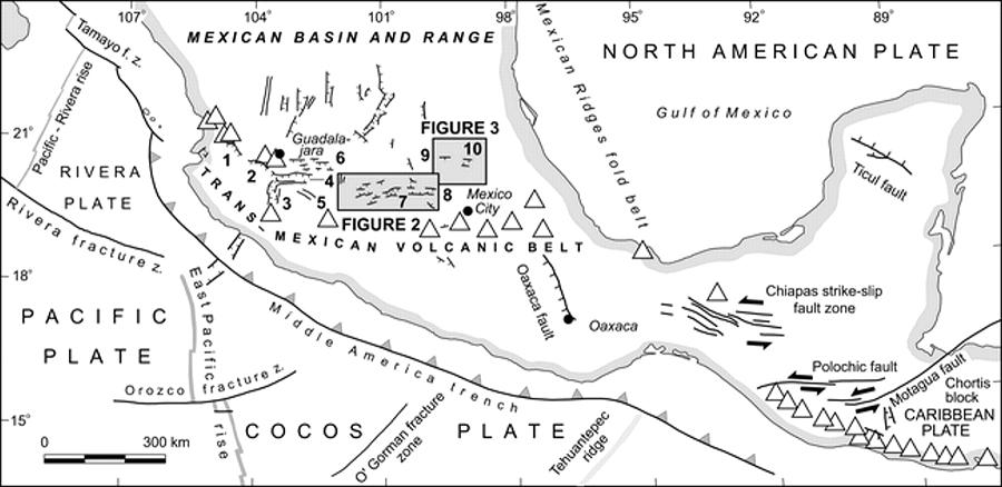
5Cotija graben; 6Altos de Jalisco fault zone; 7Cuitzeo graben |
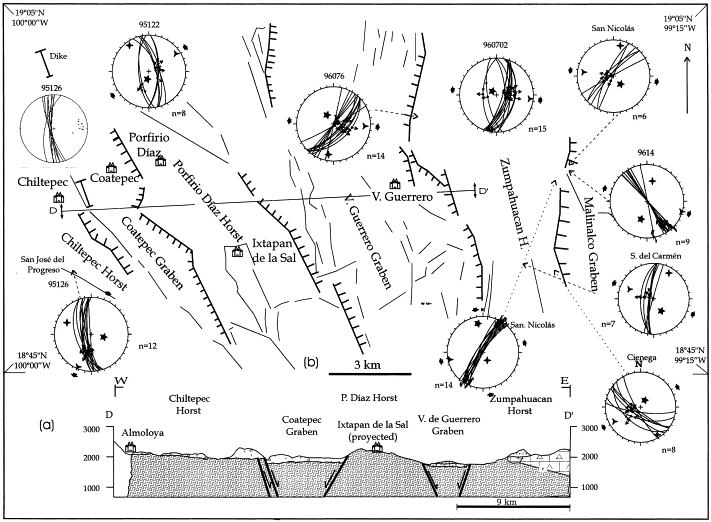
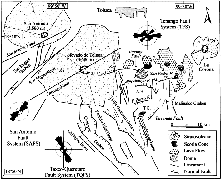
Taxco-Queretaro fault system.The black arrows indicate the principal stress orientations, and n denotes the number of faults measured at each location. (b) Cross-section of the TQFS showing the displacement of the main faults. Miocene to Recent structural evolution of the Nevado de Toluca volcano region, Central Mexico Based on aerial photography, satellite imagery, and detailed field work, a geological and structural model of Nevado de Toluca and its surroundings is presented. The Nevado de Toluca volcano is built upon the intersection of three complex fault systems of different age, orientation, and kinematics. These systems from the older to the younger are: (a) The TaxcoQuerйtaro Fault System (NNWSSE) with clear expression south of the volcano; (b) The San Antonio Fault System (NESW) that runs between the San Antonio and Nevado de Toluca volcanoes; and (c) The Tenango Fault System (EW) located to the east of Nevado de Toluca volcano. Our field data, supported by previous studies, suggest that these systems have coexisted since the late Miocene. In addition, the stratigraphy, chronology, and kinematics of fault planes point to the existence of at least three main deformation events that have affected the region since the late Miocene. During the early Miocene, an extensional phase with the same deformation style as the Basin and Range tectonics of northern Mexico caused the formation of horsts and grabens south of Nevado de Toluca and allowed the intrusion of sub-vertical dikes oriented NWSE and NNWSSE. During the middle Miocene, a transcurrent episode generated NESW faults that presented two main motions: the first movement was left-lateral with a b3 oriented NWSE and later turned into normal through a counter-clockwise rotation of b3 up to a NS position. The latest deformation phase started during the late Pliocene and produced oblique extension (b3 oriented NESW) along EW-trending faults that later changed to pure extension by shifting of b3 to a NS orientation. These faults appear to control the late Pleistocene to Holocene monogenetic volcanism, the flank collapses of Nevado de Toluca volcano and the seismic activity of the region. See more San Antonio Fault System, Tenango Fault System, Nevado de Toluca area, Malinalco graben http://www.sciencedirect.com/science/article/pii/S0040195199003169 |
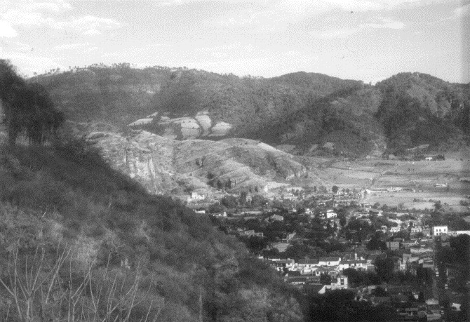
Panoramic view to the northeast of the Malinalco graben |
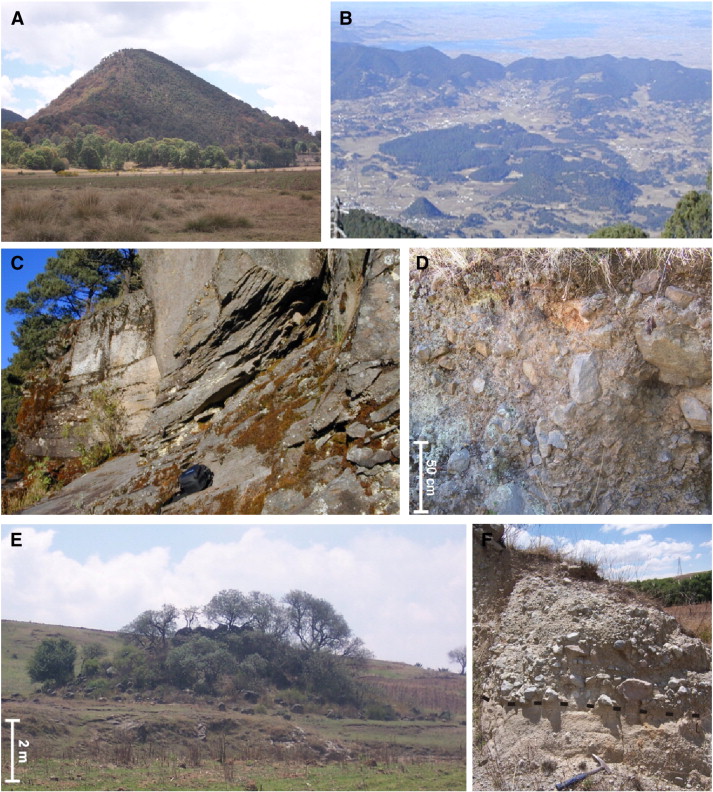
Photographs of DAD (sites located in Fig. 3). A) Hummock (site 107), notice its conical shape, it is ca. 200 m high. B) View from the Jocotitlįn summit, clusters of hummocks are seen in the central part of the deposit near the southern block of the Acambay graben. C) Sequence of lava flows emplaced on the southern slopes of the volcano (site 105), the lava is fractured into slabs (black bag for scale: 20 cm). D) Internal structure of the distal part of the avalanche deposit (site 220a) located near the boundary of the eastern sector. It is possible to observe sub-angular to sub-rounded clasts up to 60 cm in size, (average size of 20 cm), supported by a medium to coarse sand matrix. E) Distal hummock of the eastern sector. It does not show a continuous relation with the deposit and is smaller than hummocks of the northern sector. F) Terminal part of the avalanche deposit (site 222). This consists of heterolithological, normally graded, sub-rounded clasts in a medium to fine sandy matrix (hammer for scale). The structure, arrangement, distribution and morphology of the deposit point towards a cohesive debris flow behavior. Geomorphic assessment of the debris avalanche deposit from the Jocotitlan volcano, Central Mexico Edifice collapse of the Jocotitlan volcano produced a debris avalanche deposit whose morphology is characterized by conical hummocks and elongated ridges. We consulted aerial photographs, orthophotographs, and conducted field work to define field relationships between mound morphology and stratigraphy. Based on field evidence and geomorphic and geologic interpretation we sub-divide the deposit into three sectors (north, northeastern, and eastern). We determine the emplacement mechanisms of the different sectors based on their distinct morphologic and lithologic features. In this context, we generate a geomorphometric database comprising 17 variables for each mound and apply multivariate statistical methods (principal component analysis and cluster analysis) to define the relationships between them. The principal components incorporated 73% of the total data variance and seven geomorphometric variables (perimeter, major axis, area, height, distance to the source, axis ratio and circularity index) defined two groups: hummocks and ridges. The circularity index and the axis ratio best characterize the elongated form of hummocks composing the deposits. Contrasts in lithological characteristics, such as material strength and mobility, provide evidence for a transition from a sliding mass (debris avalanche deposit) to a debris-flow-like emplacement. Differences in deposit morphology suggest two collapse mechanisms: magmatic intrusion (Bezymianny-type sector collapse) and a tectonic mass-slide, an earthquake could provide the trigger for both collapses. The eastern lower flank of the volcano then collapsed gravitationally due to a movement along a fault (tectonic activity possibly related to the AcambayTixmadeje Fault System). This produced the northeastern sector of the debris avalanche deposit dominated by large elongated ridges. The spatial arrangement of both sectors (the N and NE) suggests that the two failure events occurred simultaneously. Finally, the eastern sector of the deposit was emplaced by posterior remobilization of material from the two other sectors through a debris flow. http://www.sciencedirect.com/science/article/pii/S0169555X10003089 |
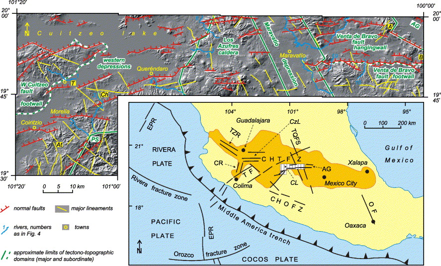
Shaded relief image (pixel size 50 m) of the study area and the location of main topographic and structural features. Lighting direction is NW. Names of tectono-topographic domains are given in green. PSPuerto La Sosa, AtAtécuaro, TTarı́mbaro, ChCharo, AAltamirano volcano, AGAcambay graben, BBosheda. Inset shows the tectonic outline map of central Mexico. Trans-Mexican Volcanic Belt is marked in dark yellow. The study area is hatched. CzLChapala Lake, CLCuitzeo Lake. Major fault systems are TZRTepicZacoalco rift, CRColima rift, TFTamazula fault, CHTFZChapalaTula fault zone, AGAcambay graben, TQFSTaxcoQuerétaro fault system, CHOFZChapalaOaxaca fault zone, OFOaxaca fault, EPREast Pacific Rise. Active fault systems and tectono-topographic configuration of the central Trans-Mexican Volcanic Belt The central Trans-Mexican Volcanic Belt (TMVB) reflects the interplay between three regional fault systems: the NNWSSE to NWSE striking TaxcoQuerétaro fault system, the NESW striking system, and the EW striking MoreliaAcambay fault system. The latter is the youngest and consists of fault scarps up to 500 m high, whose formation caused structural and morphological reorganization of the region. In this paper, we investigate possible activity of the three systems within the central TMVB, and assess the role that they play in controlling the tectono-topographic configuration of the area. Our study is based on DEM-derived morphometric maps, longitudinal river profiles, geomorphologic mapping, and structural field data concerning recent faulting. We find that all three regional fault systems are active within the central TMVB, possibly with different displacement rates and/or type of motion; and that NNWSSE and NESW striking faults control the major tectono-topographic elements that build up the region, which are being re-shaped by EW striking faults. We also find that tectonic information can be deciphered from the topography of the youthful volcanic arc in question, regardless its complexity http://www.sciencedirect.com/science/article/pii/S0169555X03003842 |
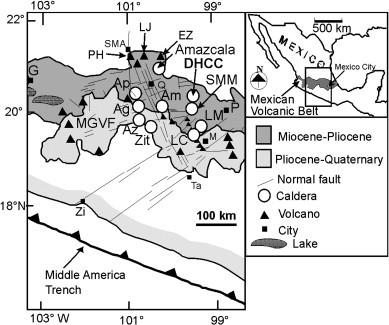
Mexican Volcanic Belt, Mexico The Donguinyo-Huichapan caldera complex is located 110 km to the NNW of Mexico City, in the central sector of the Mexican Volcanic Belt. It is a 10 km in diameter complex apparently with two overlapping calderas, each one related to an ignimbrite sequence that contrasts in composition, mineralogy, welding, distribution, and physical aspect. The geologic evolution of this complex includes the following phases, 1) A first caldera formed at 5.03 Ma, with the eruption of several discrete pulses of andesitic to trachydacitic pyroclastic flows that produced a series of densely welded ignimbrites; 2) At 4.6 Ma, several small shield volcanoes and cinder cones built the rim of this caldera and erupted basaltic-andesite and andesitic lava flows; 3) At 4.2 Ma, a second caldera was formed associated to the eruption of the Huichapan Tuff, which is a rhyolitic pyroclastic sequence consisting of minor unwelded ignimbrites, pumice fall and surge deposits, and a voluminous welded ignimbrite; 4) Also yielding an age of 4.2 Ma, several trachydacitic lava domes were extruded along the new ring fracture and formed the rim of the Huichapan caldera, as well as five intra-caldera domes of dacitic and trachydacitic composition. Peripheral volcanism includes a large 2.5 Ma shield volcano that was emplaced on the Huichapan caldera rim.The two calderas that form the Donguinyo-Huichapan complex have contrasting differences in volcanic styles that were apparently due to their differences in composition. Products erupted by the Donguinyo caldera are basaltic-andesite to trachydacitic in composition, whereas Huichapan caldera products are all high-silica rhyolites. Key: caldera, ignimbrites http://www.sciencedirect.com/science/article/pii/S0377027308005647 |
Tenancingo graben -http://www.sciencedirect.com/science/article/pii/S0040195199003169 |
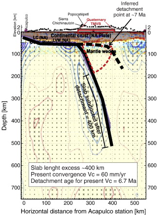
Test of the slab detachment model prediction along the MASE line. Interpretation of the present slab (thick solid black line) and inferred slab position at ~ 7 Ma is superimposed on the receiver function and tomography The dynamic history of the Trans-Mexican Volcanic Belt and the Mexico subduction zone The Trans-Mexican Volcanic Belt (TMVB) is a 1000 km long Neogene continental arc showing a large variation in composition and volcanic style, and an intra-arc extensional tectonics. It overlies the Rivera and Cocos slabs, which display marked changes in geometry. Geophysical studies indicate that lithospheric mantle is very thin or absent beneath the forearc and arc, the fluids from the slab are released in a 40 to 100 km wide belt beneath the frontal part of the arc, and the lower crust beneath the arc is partially molten. East of 101°W the TMVB is built on a Precambrian to Paleozoic crust with thickness of 5055 km. West of 101°W the TMVB is underlain by Jurassic to Cenozoic marine and continental arcs with a 3540 km thick crust.The evolution of the TMVB occurred in four stages: 1) from ~ 20 to 10 Ma the initial andesitic arc moved inland showing progressively drier melting and, eventually, slab melting, suggesting flattening of the subducted slab; 2) since ~ 11 Ma a pulse of mafic volcanism migrated from west to east reaching the Gulf of Mexico by 7 Ma. This mafic lavas marks the lateral propagation of a slab tear, triggered by cessation of subduction beneath Baja California; 3) thereafter, the volcanic front started moving trenchward, with a marked phase of silicic volcanism between 7.5 and 3 Ma, local emplacement of small volume intraplate-like basalts since 5 Ma, and development of extensional faulting. These features are related to slab rollback, enhancing asthenophere flux into the mantle wedge and promoting partial melting of the crust; 4) the modern arc consists of a frontal belt dominated by flux and slab melting, and a rear belt characterized by more differentiated rocks or by mafic lavas with little or no evidence of subduction fluids but higher asthenosphere fingerprint. http://www.sciencedirect.com/science/article/pii/S0040195111003957 |
c http://www.scielo.org.mx/scielo.php?script=sci_arttext&pid=S0016-71692009000300006
Fault segments of the SW MAFS and their seismic potential
MAFS contains by eight active normal fault segments, mainly oriented NESW or EW, with a secondary striking to NS.
QuerendaroIndaparapeo segment (QI)
QI segment begins at Los Azufres geothermal field. It is oriented to ENEWSW. Two dacitic domes were extruded and subsequently crossed by the fault. Towards Querendaro, we find andesiticbasaltic lava flows dated at 700 ka (Pradal and Robin, 1994), A >100 m scarp forms the southern boundary of the Querendaro lacustrine depression. The segment shows a SRL value of 20 km. The Mw value obtained from equation [1] ranges between 6.6 and 6.9 and the sliprate is 0.14 mm/yr. By applying the Slemons'' (1982) plot, the recurrence time period (PR) for this interval of earthquake magnitude is between 9 and 15 ka.Small graben basins and "in echelon" normal faults are associated to the main fault segment in the vicinity of Querendaro. These grabens configure a pullapart basin indicating that QI presents secondary leftlateral fault movement.
Charo segment (Ch)
This segment is also within Los Azufres geothermal field and oriented NESW. The youngest deposit affected by the movement of this segment is the rhyolitic dome of El Rosario (300 ka). Around Querendaro this segment exhibits 10 cinder cones extruded through the Miocene rocks of Sierra Mil Cumbres. In the vicinity of Charo, this segment develops triangular facets that affected Miocene volcanic rocks of Sierra de Mil Cumbres and recent fluviolacustrine sediments around La Golera area. Ch presents a SRL of 30 km and from Ec (1), the Mw value varies between 6.8 and 7.1. The fault sliprate is 0.2 mm/yr and the interval period of recurrence (PR) is between 6.7 and 10 ka.
Taimbaro and Alvaro Obregon segment (TAO)
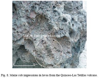
Magnetometry and georadar techniques were used to study the geometry of this segment, mainly oriented to NESW and secondary EW. TAO is 35 km long and exhibits a surface scarp greater than 100 m. At its eastern part, TAO crossed lava flows aged 8 Ma whereas at its western tip point, this segment displaces basaltic lava flows of El Quinceo Las Tetillas volcano, lava flows containing corn cob moulds (Martinez and Hobson, 1907). The most recent fault movement generated surface displacements from a few up to tens of meters (GardunoMonroy et al., 2001). Assuming that maize existed during the last 3.6 ka, the presence of maize in this fault segment means that was reactivated after 3.6 ka (Watts and Bradbury, 1982).The western termination of this segment can be observed in the zone of Las Joyitas (NW of Morelia), where the fault acted as a vent for the extrusion of two cinder cones and subsequently crossed them. The garbage dump of the city of Morelia is located there. Mw ranged between 6.9 and 7.1. Hence, TAO segment presents a nonuniform fault sliprate throughout time. The oldest materials Upper MiocenePliocene show a vertical displacement of 200m; thus the sliprate is calculated 0.025 mm/yr. Best the youngest detected movement of 3.6 ka generated a fault scarp of ca. 10 m, suggesting a fault sliprate of 2.78 mm/yr, two orders of magnitude higher than the precedent value. We suggest that the sliprate value depends on the time scale, i.e; the shortterm is the Holocene sliprate and the longterm is the Pliocene to Presentday sliprate value. More data are needed. The PR interval for the longterm case is estimated at 60 to 100 ka.
Central Morelia segments (CM)
CM is composed by two ENEWSW normal fault subsegments, located within the City of Morelia. They have downthrown blocks to the north and scarp heights of 20 to 60 m. One of them is located in the northern part of the city (El Realito, Guadalupe and La Colina districts) and the other is the downtown area next to the bus station. Assuming total coseismic rupture of both subsegments SRL reaches ca. 5.5 km, Mw ranges between 5.8 and 6.5. The fault sliprate is 0.12 mm/yr and the PR from 4.5 to 8 ka.Surface subsidence occurs along this fault at a rate of 4 to 6 cm/yr two orders of magnitude faster than the seismic sliprate. It could cause severe damage to buildings. This process may be a result of over exploitation of groundwater.
La Paloma segment (LP)
Morelos segment (Mo)
Mo segment is 6 km long south of Morelia City. The main orientation is to ENEWSW affecting Upper Miocene to Pliocene deposits (Morelia ignimbrite). The accumulated vertical fault displacement is ca. 50m Mw ranges between 5.9 and 6.5 and this segment exhibits the lowest sliprate in the studied area (0.009 mm/yr). By applying the Slemons'' (1982) curve, the PR varies between 40 and 100 ka. Mo may be considered as a bifurcation of the Cointzio segment (Ctz).
Cointzio segment (Ctz)
Ctz segment cuts Miocene rocks, Morelia ignimbrite and, towards the west, displaces the eastern flank of the Cerro El Aguila shield volcano. It is a normal fault oriented towards NESW, with a downthrown block to the north and with a scarp of 100 m height. It forms the northern border of the Cointzio dam at Cerro El Aguila, it displaces lavas of 500 ka. Considering the scarp height, the estimated slip rate is 0.2 mm/yr. Ctz is a 15 km long and may generate earthquakes with Mw between 6.4 and 6.8 and with a period of recurrence 30 < PR < 60 ka.
Huiramba segment (Hu)
This fault segment is discontinuous and extends from the southern part of Huiramba to Cerro El Aguila. The main orientation of Hu is to NS and with a SRL value of 10 km. Towards the SW of the Cerro El Aguila volcano, the orientation of Hu changes NNESSW. Near of the town of Hiuramba, this segment shows normal faulting with hanging walls to the W and surface throw of about 50 m. A small graben with the same orientation NS is developed on the southern side of the Cerro El Aguila volcano. Hu affects andesiticdacitic domes with an age lesser than 500 ka. The earthquake magnitude interval is (6.2 6.7) with a fault sliprate of 0.1 mm/yr. The time period of recurrence varies between 4.5 and 10 ka.
Patzcuaro segment (Pa)
Pa segment extends from Erongaricuaro to the City of Patzcuaro, and is oriented to EW. This segment develops the graben of JaracuaroPatzcuaro, which is related to the almost 40m uplift of the island of Jaracuaro. The volcano La Taza (8 Ka) (19° 31'' 35''N; 101° 43'' 29 ''W) and the avalanche deposits and collapse of volcano El Estribo, are related to the Pa segment. These avalanche deposits and collapse were generated by M>6 earthquakes.
The SRL value suggests earthquakes ranging between 6.4 and 6.8. The tectonic uplift of Jaracuaro Island and the age of the last paleoseismic event, suggest a fault sliprate greater than 2.5 mm/yr. This value exceeds sliprates for the precedent segments of MAFS, by one order of magnitude, but is similar to the shortterm sliprate for the TAO segment. We interpret this value as the shortterm sliprate for the Pa segment (Holocene).
The main result of the seismotectonic analysis is a estimated M7.1 the potential maximum expected earthquake, with PR values ranging between 60 and 100 ka (TAO segment). The minimum PR interval is (4.58) ka for earthquake sizes of (5.86.5) in the CM segment. The Ch segment presents the same potential maximum size M7.1, but PR is between 6.7 and 10 Ka. All segments are near Morelia City, thus the seismicity is relevant for future hazard studies.
Discussion
Age of the Morelia Acambay Fautling
The age of the TMVB has been controversial. Recent dates have established that volcanism in this arc began ~ 12 Ma ago.I n the study area, the oldest lacustrine sequence has MiocenePliocene age. In the Charo region the oldest lacustrine deposits were dated at 7 Ma. At Los Azufres, Pradal and Robin (1994) dated monogenetic volcanism of Querendaro at 700 ka and the lavas were cut by the MoreliaAcambay fault. Further north, in the Araro region, proximal lacustrine deposits with PirindaPurhepecha pottery shards were raised 20 m by the EW faults. In the Morelia region, the MAFS structures displace Upper Miocene (12 Ma) volcanic sequences while further north, in the Tarimbaro region, EW faults cut the lavas of the Holocene Quinceo volcano, that contain maize cob casts. Fallout deposits of the QuinceoLas Tetillas volcanoes containing pottery shards were also displaced by EW faults.
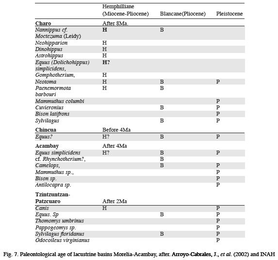
Paleontological studies performed between Acambay and Cuitzeo suggest the following dates:
1. In Tierras Blancas and San Bartola Lanzados, Acambay, Mercer et al. (2002) reported interbedded lacustrine sequences with fallout layers of ash and pumice dated at 1.2 Ma (Late PlioceneEarly Pleistocene). These lacustrine layers contain Equus simplicidens, c.f. Rhynchotherium ?, Camelops sp., Mammuthus sp., Bison sp. and Antilocarpa sp. This fauna confirms the of PliocenePleistocene age of this lacustrine basin and an important tectonic activity synsedimentary.
2. The Pastores fault south of Tierras Blancas and San Bartola Lanzados basin displaces lavas dated by Suter et al. (1995) at 0.4 Ma (Pleistocene).
3. In a small EW basin in Chincua, a lacustrine column revealed molars of Equus sp. and Cuvieronis sp., which assigns a MiocenePliocene age to the deposits. The lacustrine sequence is covered by a gray ignimbrite deposit dated 4 Ma, which agrees with a MiocenePliocene age the basin.
4. In Zaragoza, Michoacan, remains of Mammuthus columbi (Falconer) 1857 was found in a small basin bounded by EW faults, dated Middle to Late Pleistocene.
5. Several authors have made stratigraphic and paleontological studies in a lacustrine sequence in Charo that is tilted and cut by EW and NNWSSE faults. They found recorded a rich vertebrate fauna of Proboscidea, Artiodactyla, Peris sodactyla, Lagomorpha, Rodentia and Birds from Early Pliocene to Pleistocene, as corroborated by a date of 3.6 Ma a cinder cone. Israde (1995) reported a date from the lacustrine sequence base of 7 Ma (Upper Miocene).
The evidence suggests that MAFS structures originated evidence suggests that MAFS structures originated in the Upper Miocene. By 7 Ma, the lacustrine basins were depressions that were accumulating sediments, their origin must date back to 810 Ma ago as does inception of the EW MoreliaAcambay faults.
Activity of some segments of MAFS is demonstrated at La Paloma where historical paleosols dated at 1.6 ka are displaced. Fallout contains pottery shards and the Araro lacustrine sediments contain prehispanic ceramics
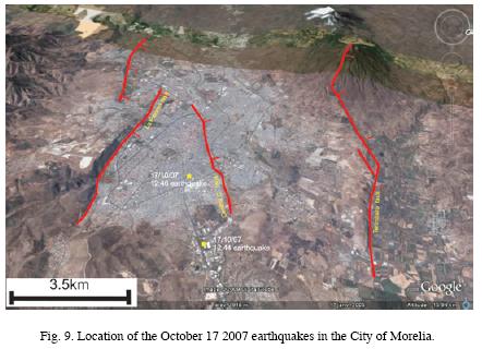
Four small earthquakes occurred on October 17, 2007, around the City of Morelia. Three of these events were located by the National Seismological Service. They had magnitudes varying from 3.5 to 3.8, with depths between 16 km. Such shallow events were not related to subduction of the Cocos Plate, they originated along EW segments of MAFS. The epicenters of were located along the Central Camionera fault. The length of this fault (8 km), suggests that it originate an earthquake of magnitude >3 and accelerations of 12 gales. Such an event can be felt by the population, as in the case of the October 2007 events. The focal mechanism of the earthquakes agrees with the geometry of the Central Camionera fault and possible segments to the west.
This earthquake activity corroborates that EW segments of MAFS are subjected to a regional tensional field of the TMVB, and that they may be reactivated in the future. At present, only a small segment of MAFS has been activated; if the regional tensional field activates a larger segment (i.e. La Paloma fault) a stronger earthquake could occur with damage to the urban area of Morelia, as in the 1858 earthquake.
Fault inception and evolution of lacustrine depressions
The NNWSSE faults have often been considered to be structures inherited from the north Mexican Basin and Range province. However, our study suggests that these faults may have been reactivated during the formation of the lacustrine depressions of the TMVB, since the orientation of these basins correspondsextension with a NWSE orientation that is still active in the central part of the TMVB, Therefore the inherited NWSE structures have a rightlateral component. This may be observed in the TzitzioValle de Santiago structure, which must be a northern component of the TaxcoQueretaro Fault System that strongly controls the distribution of volcanism, causing displacement towards the SE.
The scarps of MAFS in the study region have heights ranging between 20 and 200 m. They are often larger at the eastern end of the fault. For example, the eastern tips of La Paloma and Tarнmbaro segments terminate abruptly with scarps higher than 200 m. Toward the west the scarp height decays gradually to ~20 m. These faults must be linked at depth to the eastern segments a cross relay ramps. The Tarimabro fault would be linked to the Alvaro Obregon fault and the La Paloma fault to the Jaripeo fault. If so, the MoreliaAcambay fault system may be coalescence stage (see also Suter et al., 2001), with individual faults linked at depth. Collapse scars are found in Patzcuaro and throughout the region (e.g. at Patzcuaro lake islands or La Paloma fault). Therefore, it appears that the Patzcuaro and La Paloma faults are seismically active, with Holocene and historical earthquakes as recorded. The Araro segment is also active as suggested by displacements in historical lacustrine units plus recent seismicity.
Earthquakes in the central TMVB are either subductionrelated (deep interplate or intermediatedepth normal faults), shallow MAFSrelated earthquakes. Both types of earthquakes might respond to regional structure of MAFS. For the western MAFS segments, the historic seismicity (two major earthquakes in 1845 and 1858) felt in Morelia and Pбtzcuaro, could not be related to EW striking faults. Instead, the shape of the 1845 and 1858 earthquakes isoseismals reveals that even in subductionrelated earthquakes, the distribution of lacustrine sediments related to EW faults controls the intensity of damage. The response of the terrain depends of the underlying material. In the studied area, there are two different types of substrate:
(1) In the Patzcuaro region, lava flows overlie lacustrine clays oversaturated with. The 1858 earthquake caused a water level rise in Pбtzcuaro Lake, possibly in response to pressure exerted on oversaturated clays. A tsunami in the lake caused the collapse of over 120 adobe houses. El Estribo, El Metate and Janitzio volcanoes have suffered major collapses during seismic events over the last 30 ka.
(2) In Morelia, ancient lacustrine plains are vulnerable to earthquakes. A seismic microzonification study revealed that some quarters (Prados Verdes, Policia, and Transito) responded unfavorably to earthquakes, A larger earthquake may cause sever losses.
Conclusions
Prior
Paleoseismology of the southwestern MoreliaAcambay fault system, central Mexico
