 | South and East California Volcanoes |
|
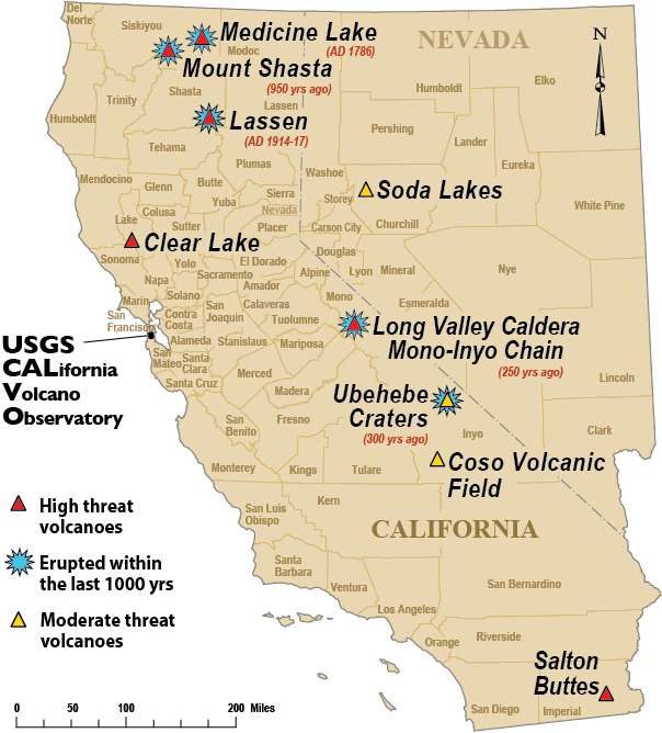
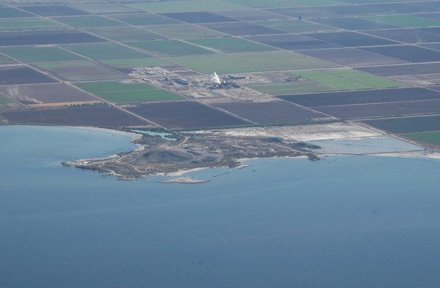
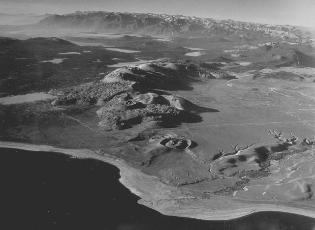
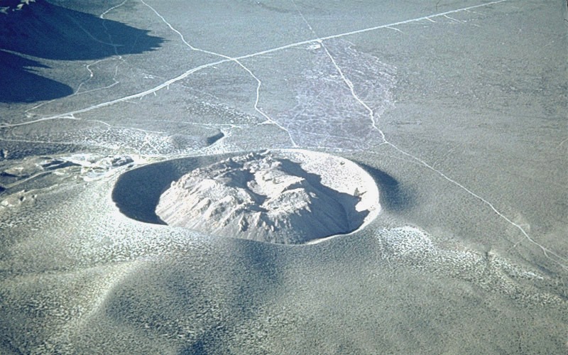
The morphology of Obsidian Butte and its surrounding flow indicates that they were produced by a single volcanic eruption with extrusion from a single, central vents. The obsidian domes, spines, and breccia mounds that ring the flow are interpreted to be pressure features developed at the outer margin of the flows. Obsidian Butte itself is topographically higher than the flow because of a late pulse of magma that pushed up a central, viscous mass of partly crystallized rhyolite. The Obsidian Butte volcanic rocks were extruded subaerially but were covered by Lake Cahuilla and modified by wave action soon thereafter. Obsidian Butte on the SE shore of the Salton Sea is seen in an aerial view from the NW. Obsidian Butte is one of five small rhyolitic lava domes extruded onto Quaternary sediments of the Colorado River delta; the summit of the dome lies 40 m below sea level. Two domes, Mullet Island and Red Island (not visible in this view), form small islands just offshore to the NE of Obsidian Butte. A steam plume rises from the Salton Sea geothermal field behind the dome. Photo by Bruce Perry, 2005 (California State University Long Beach) - http://www.volcano.si.edu/world/volcano.cfm?vnum=1203-20-&volpage=photos&photo=120100. |
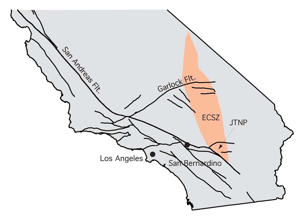
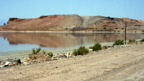
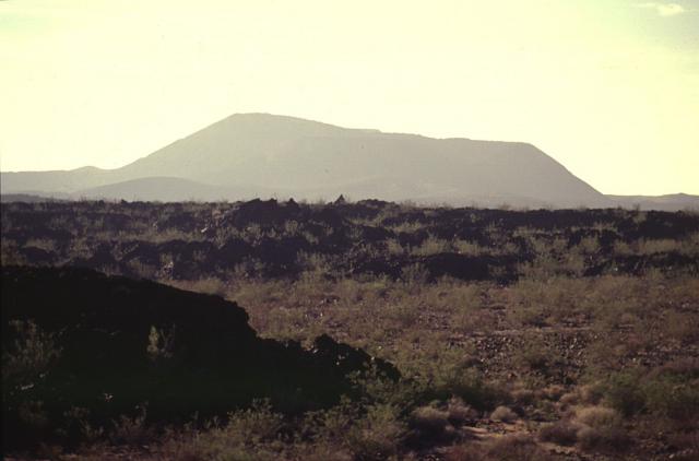
A map of the Eastern California Shear Zone, where there is a plate boundry, a good many faults and a rifting zone that will eventually separate California from the North American mainland. It has already done so further to the south, where Baja California is drifting away from mainland Mexico (North American Plate). Salton Buttes Volcano is at the southern tip of the pinkish area -http://geologycrawl.blogspot.com/2012/02/earthquake-swarm-at-salton-buttes.html. The Salton Buttes lie within the Salton Sea Geothermal Field, where temperatures at 1.5 to 2.5 kilometers reach 360 degrees C, and sediments of the Colorado River delta are being metamorphosed to greenschist facies. Both rhyolitic and basaltic intrusive rocks have been encounted by geothermal wells. A 5x8-kilometer magnetic high beneath Salton Buttes appears to represent either a batholith of a large dike swarm at depth. The dome field, the intrusive rocks, and the geothermal system are all manifestations of a spreading center beneath the sediments of the Colorado River delta, as part of the leaky transform fault that is transitional from the Gulf of California to the San Andreas fault system. The Salton Buttes are the youngest extrusions of a bimodal basalt-rhyolite system that probably existed throughout the Quaternary. Extrusions older than latest Pleistocene, however, are now buried by sediments of the Colorado River delta. The Salton Buttes are at the southeast end of the Salton Sea, in the Imperial Valley of southern California, approximately 165 kilometers ENE of San Diego. Obsidian Butte, Red Island, and Rock Hill are accessible by road; Mullet Island can be reached only by boat - http://vulcan.wr.usgs.gov/Volcanoes/California/SaltonButtes/description_salton_buttes.html Many recent studies (Wilson, 1965; Atwater, 1970; Larson and others, 1972; Moore, 1973) have suggested that the Gulf of California is the locus of a spreading ridge along which the Pacific Plate is being rifted away from the North American Plate at a rate of perhaps as much as 6 centimeters per year (Larson, 1972). |
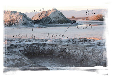
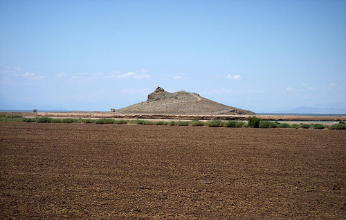
Here is a couple of vents at Salton Butte volcano, where brine is super heated by cooling magma about a mile and a half down, and brought to the surface, along with Co2 and Sulfurhttp://geologycrawl.blogspot.com/2012/02/earthquake-swarm-at-salton-buttes.html.The Salton Buttes rhyolite center: Most recent eruption: Silicic pyroclastic and extrusive eruptions at four vents approximately 16 KA (Potassium-Argon dating); Five silicic domes erupted; At least one silicic lava flow associated with rhyolite dome; Probable small-volume pyroclastic eruptions with tephra associated with dome emplacement at several vents; No recognized debris avalanches or debris flows; Most probably future potential hazard: Explosive and extrusive rhyolitic eruptions; phreatic and phreato-magmatic eruptions. Although the youngest eruptions in this area are not known to have produced pyroclastic flows and surges, the compositions of lavas of past eruptions and the association of vents with ground water and the Salton Sea suggest that pyroclastic flows and surges and explosive eruptions could occur in the future. Such events commonly are destructive out to distances of at least 10 kilometers (6 miles) from an active vent- http://vulcan.wr.usgs.gov/Volcanoes/California/SaltonButtes/description_salton_buttes.html The Salton Buttes are four small volcanoes designated from southwest to northeast as Obsidian Butte, Rock Hill, Red Island, and Mullet Island. Red Island is composed of two domes linked by a deposit of subaqueous pyroclastic material; the other volcanoes are single domal extrusions with or without marginal lava flows. The domes are spaced at intervals of 2 to 3 kilometers along a northeast trend.Five silicic domes erupted from four vents about 16 KA ago -http://vulcan.wr.usgs.gov/Volcanoes/California/Hazards/Bulletin1847/table_holocene_volcanoes.html |
Obsidian, volcanic stone valued by native Americans for millennia for making arrowheads and spear tips and for trading with other tribes, are seen scattered around Red Hill on July 6 near Calipatria, California. Red Hill is one of the four Salton Buttes, small volcanoes on the southern San Andreas Fault, at the Salton Sea. Scientists have discovered that human-created changes effecting the Salton Sea appear to be the reason why California''s massive "Big One" earthquake is more than 100 years overdue and building up for the greatest disaster ever to hit Los Angeles and Southern California. Researchers found that strands of the San Andreas Fault under the 45-mile long rift lake have have generated at least five 7.0 or larger quakes about every 180 years. This ended in the early 20th century when authorities stopped massive amounts of Colorado River water from periodically flooding the into this sub-sea level desert basin. Such floods used to regularly trigger major quakes and relieve building seismic pressure but the last big earthquake on the southern San Andreas was about 325 years ago. Dangerous new fault branches that could trigger a 7.8 quake have recently been discovered under the Salton Sea- http://www.zimbio.com/pictures/9D8juYEzGN0/Research+Shows+San+Andreas+Fault+May+Overdue/Q7a3K0ZqQmi |
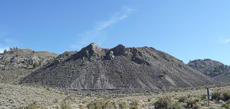
Red Hill, one of the four Salton Buttes, small volcanoes on the southern San Andreas Fault, at the Salton Sea is seen on July 6 near Calipatria, California. Scientists have discovered that human-created changes effecting the Salton Sea appear to be the reason why California''s massive "Big One" earthquake is more than 100 years overdue and building up for the greatest disaster ever to hit Los Angeles and Southern California. Researchers found that strands of the San Andreas Fault under the 45-mile long rift lake have have generated at least five 7.0 or larger quakes about every 180 years. This ended in the early 20th century when authorities stopped massive amounts of Colorado River water from periodically flooding the into this sub-sea level desert basin. Such floods used to regularly trigger major quakes and relieve building seismic pressure but the last big earthquake on the southern San Andreas was about 325 years ago. Dangerous new fault branches that could trigger a 7.8 quake have recently been discovered under the Salton Sea.Rock Hill rises approximately 25 meters above the alluviated surface of the Imperial Valley. It is composed of medium-gray rhyolite that is locally spherulitic, with minor obsidian and a discontinuous mantle of pumice. ... The foliation forms a crude dome with rather steep dips to the west-southwest and gentler dips to the north-northeast. Rock Hill is very similar to Obsidian Butte, but if a flow ever surrounded Rock Hill, it is now completely covered by the Colorado River alluvium |
Red Island is made up of two separate rhyolite domes, each mantled by subaqueous pyroclastic deposits and by later gravels and alluvium.Red Island is made up of two separate rhyolite domes, each mantled by subaqueous pyroclastic deposits and by later gravels and alluvium. The northern dome, which rises approximately 30 meters above the valley floor, has been extensively modified during construction of a marina and trailer park, and much of the gravel that overlies the southern dome has been removed by quarrying |
Rock Hill is composed of medium-gray rhyolite that is locally spherulitic, with minor obsidian and a discontinuous mantle of pumice-Salton Buttes. |
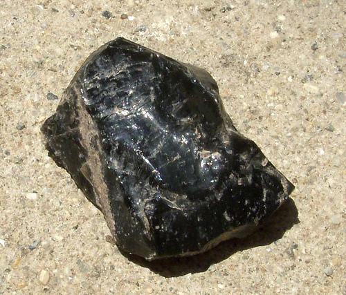
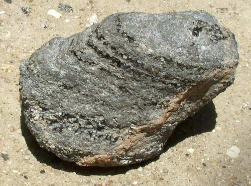
Salton Buttes.Obsidian- http://saltongeology.wikidot.com/the-salton-buttes |
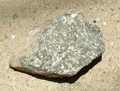
Salton Buttes . Green rock formed in a dike. |
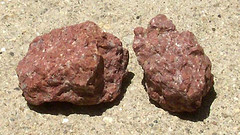
Salton Buttes. Red Rhyolitic Rock retrieved from around Red Island. |
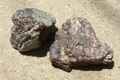
Salton Buttes.Two Rhyolitic rocks with large vesicles |
Salton Buttes. Layers of Obsidian and frothy Pumice probably formed in one volcanic explosion |
The part of Mullet Island presently exposed above the Salton Sea is composed of medium-gray spherulitic rhyolite. Foliation int he rhyolite clearly defines a simple dome which near the center of the island becomes a north-northeast-trending anticline sheared off on the north end. The domal foliation pattern, the crudely radial lineations, and the tension cracks nearly normal to the lineations suggest that the extrusion grew by outward expansion from a central point, resulting in an onion-skin pattern of foliation. An area of warm ground and active hydrothermal alteration coincides with the topographic and structural crest of Mullet Island. Several warm springs rich in CO2 occur on the northeast side of the island. The east side of Mullet Island is mantled by a deposit of gravel and sand composed entirely of pumice and gray rhyolite eroded from the island and deposited by wave action. The flat top of Mullet Island, although considerably modified by man''s activities, pro bably represents an old wave-cut surface that now lies 12 meters above the present level of the Salton Sea- http://vulcan.wr.usgs.gov/Volcanoes/California/SaltonButtes/description_salton_buttes.html. |
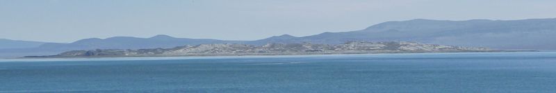
Boiling hot spring at the Salton Sea with Holocene rhyolite dome of Mullet Island in the background.The Salton Sea geothermal field lies in the Salton Trough, the landward extension of the Gulf of California, an area of active crustal spreading. Surface volcanic rocks of the field consist of five small rhyolite domes extruded onto Quaternary sediments of the Colorado River delta. Two domes are linked by subaqueous pyroclastic deposits; the others are single extrusions with or without marginal lava flows. The domes are low-calcium, alkali rhyolite with 1 to 2 percent crystals. Similar silicic rocks found in wells have been extensively altered by geothermal brines.The (Salton Buttes) volcanoes lie within the Salton Sea geothermal field where temperatures measured in wells drilled for geothermal brines range up to 360 degrees C at depths of 1,500 to 2,500 meters (Helgeson, 1968). The wells produce a hot brine containing up to 160,000 ppm of dissolved solids, chiefly Cl, Na, K, Ca, and Fe (White, 1968). Under the influence of this hot saline brine, the sediments of the Salton Trough are being transformed into metamorphic rocks of the greenschist facies (Muffler and White, 1969). |
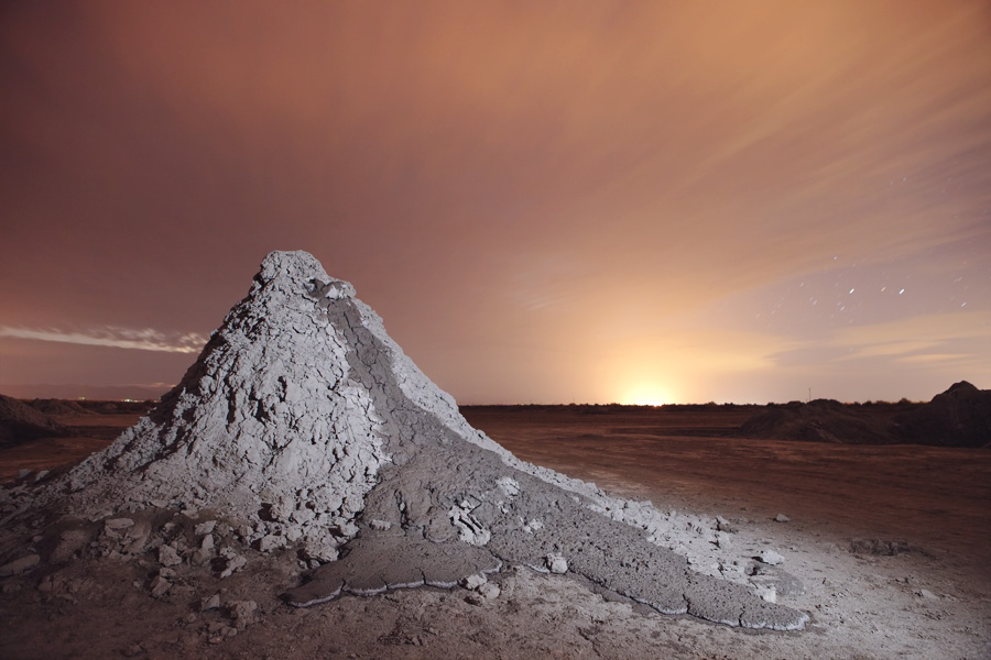
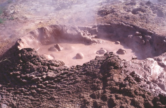
Salton Buttes. Mud volcano. The Salton Buttes lie within the Salton Sea geothermal field, where temperatures at 1.5 to 2.5 kilometers reach 360 degrees C, and sediments of the Colorado River delta are begin metamorphosed to greenschist facies. http://vulcan.wr.usgs.gov/Volcanoes/California/SaltonButtes/description_salton_buttes.html |
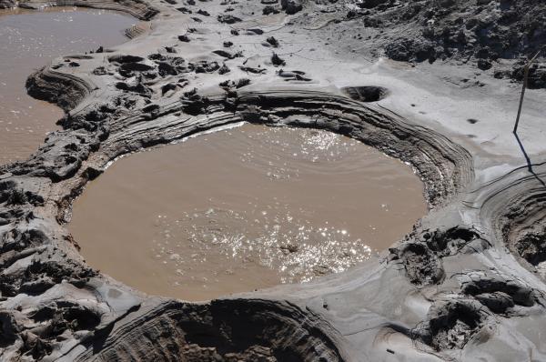
Some of southern California mudpots are gray in color while others are a rich shade of reddish brown. Here in the San Andreas Rift Valley , these amazing geothermal features gurgle, burp and croak as thousands of cars rush by them on nearby highways. (Credit: Linda and Dr. Dick Buscher)-http://thewatchers.adorraeli.com/2012/02/12/new-volcano-observatory-in-california-to-monitor-dozens-of-potentially-threating-volcanoes/ |
The Davis-Schrimpf seep field is located about 40 miles (64 kilometers) southeast of Palm Springs, Calif., at an elevation of 230 feet (70 meters) below sea level. Here, carbon dioxide gases gurgle to the surface as a result of a magma zone Ч found 1 mile (1.6 km) below the Earth''s surface Ч cooking the gas from carbonate minerals. (Credit: Linda and Dr. Dick Buscher.)- http://thewatchers.adorraeli.com/2012/02/12/new-volcano-observatory-in-california-to-monitor-dozens-of-potentially-threating-volcanoes/ |
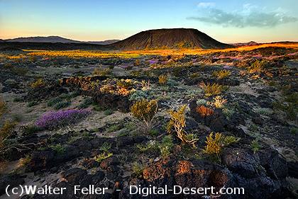
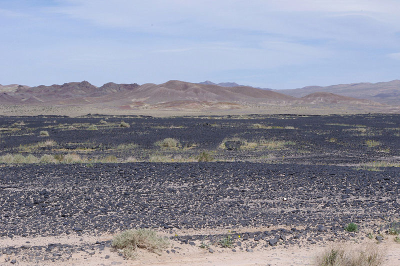
Interior of Amboy Crater showing a lava lake and the distant breach in the cinder cone rim.This Cinder cone crater is estimated to be around 6,000 years old and was formed in layers of mostly vesicular pahoehoe - possibly in the Holocene geological period. The interior has a lava lake. Lava flows as old as Amboy Crater itself blanket the surrounding area. According to the BLM interpretive sign the last eruption could have been as recently as 500 years ago- http://en.wikipedia.org/wiki/Amboy_Crater |
Amboy Crater. Several mafic lava flows and cinder cones from several vents during last approximately 10,000 years. Mafic tephra erupted at several vents during past approximately 10,000 years. Mafic cinder cones and lava flows of apparent early Holocene age.Formation of cinder cones, small volumes of tephra, and lava flows; phreatic explosions- http://vulcan.wr.usgs.gov/Volcanoes/California/Hazards/Bulletin1847/table_holocene_volcanoes.html. Volcanic eruptions don''t occur everywhere. Several "ingredients" must combine at the right place and time. While geologic complexities of Southern California are still under investigation, many researchers think that faulting, block movement, and associated magma production are key ingredients contributing to the formation of cinder cones and lava flows in the Mojave Desert. During the Mesozoic Era (245-65 MA), extensive tectonic activity in western North America resulted in a dynamic period of volcanism and faulting as the Pacific Plate began to slide beneath the North American Plate. Then, around 30 MA, great fault systems developed further throughout present-day California. Regional movement of these faults cracked the earth''s crust into blocks. As the plates and blocks of the earth''s crust slide and rotate, they generate friction and and tremendous heat. Beneath the Mojave, rocks of the lower crust melted. Because it is less dense than the surrounding rock, the melted, mantle-derived basalt or magma, rises toward the surface. When magma cannot find a path upwards it pools into magma chambers. The chambers can be huge, providing enough magma for many volcanos over several years. To form a volcano, however, magma must reach the surface. The spaces between fault blocks are zones of weakness reaching down to the mantle. Pressure within magma chambers was released as eruptions through such fractures or vents in the earth''s crust , providing magma with a way up and out. With this final ingredient, a hot and "fresh" volcano is formed -http://digital-desert.com/lava/. |
Amboy lava field |
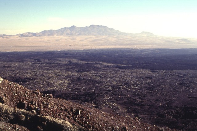
Lavic Lake volcanic field. The Lavic Lake volcanic field is a volcanic field with extinct cinder cones in the Mojave Desert. The lava field, at 1,495 m elevation, and its cones can be seen from historic Route 66 and from Interstate 40, between Barstow to the west and Needles to the east, and is located southeast of Ludlow, California. The 100 km2 Lavic Lake volcanic field is a basaltic pahoehoe lava plain and has four Holocene (approximately 10KA) cinder cone type volcanos, three in the Lavic Dry Lake area, and a fourth located southwest in the Rodman Mountains. The oldest cinder cone, Pisgah Crater may be pre-Holocene, erupting around 25 KA.Of the four cinder cones, Pisgah Crater stands as the most accessible and prominent volcano in the volcanic field with a height of 100 m above the field with a peak elevation of 1,595 m. The cone of Pisgah Crater has been modified by mining operations that provide a source of road aggregate.The biome is the deserts and xeric shrublands, with smaller plants growing in soil pockets formed by erosion, sedimentation and wind deposits- http://en.wikipedia.org/wiki/Lavic_Lake_volcanic_field |
The NE rim of Pisgah Crater provides a view of the 100-sq-km lava field surrounding the crater. The basaltic lava field was erupted from the crater and nearby vents and is dominantly formed of pahoehoe lava, although aa lavas were erupted on the eastern side. Interstate highway 40 skirts the northern margins of the lava flow, below the Cady Mountains in the distance. The lavas were erupted onto alluvial-fan and playa-lake deposits. Photo by Paul Kimberly, 1997 (Smithsonian Institution). |
Pisgah Crater is the most prominent feature of the Lavic Lake volcanic field, which contains four Quaternary cinder cones. The 100-m-high Pisgah Crater, seen here from the NW, and its surrounding 100-sq-km lava field are easily seen from nearby Interstate highway 40. The crater and nearby vents were the source of dominantly pahoehoe lava flows that traveled as far as 18 km NW over alluvial-fan and playa-lake deposits. Pisgah Crater was initially considered to be Holocene in age, but more recent dating indicates it is about 25,000 years old. Photo by Paul Kimberly, 1997 (Smithsonian Institution)- http://www.volcano.si.edu/world/volcano.cfm?vnum=1203-19-&volpage=photos&photo=067054 |
A freight train passes Pisgah Crater and its associated lava field. The 100-m-high cone is the most prominent feature of a lava field that covers 100 sq km. The irregular shape of the cone results from the mining of aggregate. The composite lava flows extend up to 8 km to the SE and in a narrow lobe 18 km to the NW. Most of the flows are pahoehoe, but some of the eastern flows are aa. Other cones and lava flows of the Lavic Lake volcanic field are located nearby.Photo by Lee Siebert, 1997 (Smithsonian Institution). |
The dark-colored area seen in the distance across the dry Lavic Lake is a cinder cone and associated lava field that is one of the young vents of the Lavic Lake volcanic field. The youthful-looking lava flows originated from the Sunshine Peak area of the Lava Beds Mountains, south of the better known Pisgah Crater - http://www.volcano.si.edu/world/volcano.cfm?vnum=1203-19-&volpage=photos&photo=067055 |
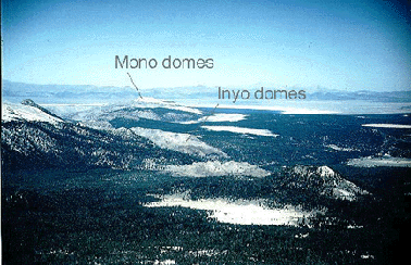
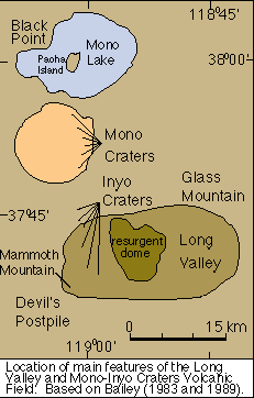
The history and deposits of the Mono-Inyo Craters volcanic field overlap with Long Valley caldera in time and space. The Mono-Inyo Craters volcanic field developed along a 30-mile-long (50 km) fissure system that extends northward from Mammoth Mountain on the southwestern rim of the caldera to Mono Lake. Mafic eruptions began 300-200 KA within the caldera and migrated to the north. The youngest mafic lavas erupted at Black Point near Mono Lake 13,3 KA -http://volcano.oregonstate.edu/vwdocs/volc_images/north_america/california/long_valley.html. |
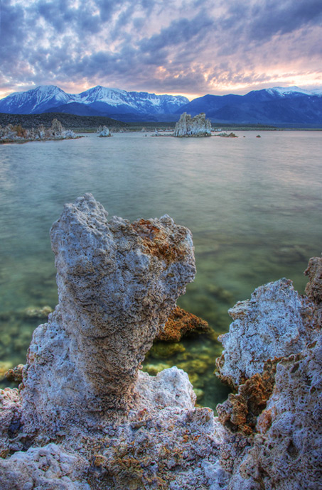
Mono Lake Tuffite |
http://www.zacktravel.com/amazing-mono-lake/ |
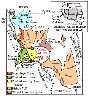
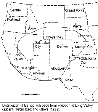
Long Valley was formed 760 KA ago when a huge volcanic eruption released very hot ash that later cooled to form the Bishop tuff that is common to the area. The eruption was so colossal that the magma chamber under the now destroyed volcano was emptied to the point of collapse. The collapse itself caused an even larger secondary eruption of pyroclastic ash that burned and buried thousands of square miles. Ash from this eruption blanketed much of the western part of what is now the United States. Geologists call topographic depressions formed in this manner calderas http://en.wikipedia.org/wiki/Long_Valley_Caldera http://volcano.oregonstate.edu/vwdocs/volc_images/north_america/california/long_valley.html |
Volcanic activity began in the area about 3.6 MA when trachybasalt and trachyandesite lava flows covered an area of about 4,000 square km. A short time later, geologically speaking, rhyodacite was erupted as flows and domes. Geologists interpreted these more silica-rich compositions as the first eruptive products of a growing magma chamber. The Long Valley caldera was produced by a catastrophic eruption about 730 KA. The roof above the magma chamber collapsed, forcing 600 cubic km of rhyolitic magma to the surface in the form of Plinian ash columns and associated air falls and ash flows. The volume of ash is comparable to similar caldera-forming eruptions at Yellowstone and far exceeds the volume of ash erupted from stratovolcanoes. For example, the large eruption of Tambora in 1815 produced 40 cubic km of ash -http://volcano.oregonstate.edu/vwdocs/volc_images/north_america/california/long_valley.html. |
http://en.wikipedia.org/wiki/Mono%E2%80%93Inyo_Craters |
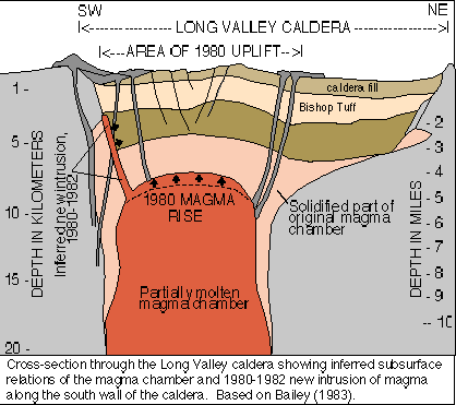
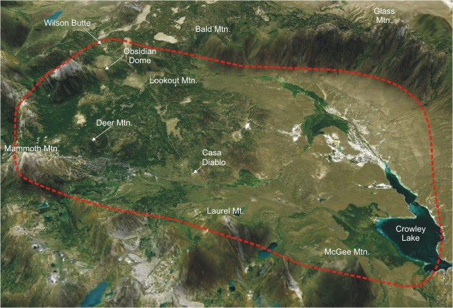
Long Valley caldera, located at the boundary between the Sierra Nevada and the Basin and Range Province, is one of the largest Quaternary rhyolitic volcanic centers in North America. View of the Long Valley caldera looking to the north. Dashed line is approximate rim of caldera. The 16 x 32 km Long Valley caldera east of the central Sierra Nevada Range formed as a result of the voluminous Bishop Tuff eruption about 760KA. Resurgent doming in the central part of the caldera occurred shortly afterwards, followed by rhyolitic eruptions from the caldera moat and the eruption of rhyodacite from outer ring fracture vents, with the last eruptions inside the caldera about 50 KA. During early resurgent doming the caldera was filled with a large lake that left lake-shore traces (strandlines) on the caldera walls and the resurgent dome island; the lake eventually drained through the Owens River Gorge. The caldera remains thermally active, with many hot springs and fumaroles, and has had significant deformation, seismicity, and other unrest in recent years. The late-Pleistocene to Holocene Inyo Craters cut the northwest topographic rim of the caldera in 1,350 AD, and along with Mammoth Mountain on the southwest topographic rim, are west of the structural caldera and are chemically and tectonically distinct from the Long Valley magmatic system. The most recent activity in the area was about 300 years ago in Mono Lake. Location: California, Mono County. Elevation: 2,600 (m) Composition: basalt to rhyolite. Most recent eruption: 50 KA - http://volcanoes.usgs.gov/volcanoes/long_valley/ |
Red Cones, Long Valley Caldera. This cone is one of two cinder cones called the Red Cones, located about 5 km south of Mammoth Mountain volcano and Long Valley Caldera in California. These basaltic cones and associated lava flows were erupted about 5 KA.Photograph by C.D. Miller in 1982- |
The Bishop tuff was erupted during the catastrophic eruption that created Long Valley caldera -http://volcano.oregonstate.edu/vwdocs/volc_images/north_america/california/long_valley.html |
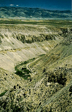
Bishop tuff exposed in the Owens River Gorge in the eastern Sierra Nevada. The White Mountains are in the background. View is to the southeast. Photo by R. Forrest Hopson - http://volcano.oregonstate.edu/vwdocs/volc_images/north_america/california/long_valley.html |
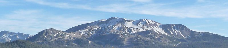
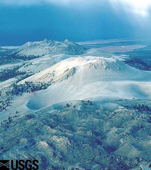
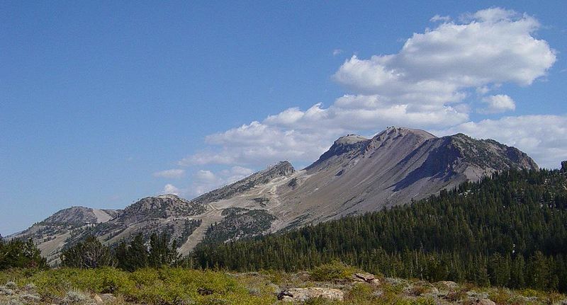
After the catastrophic eruption, volcanism continued on the caldera floor, producing a thin layer rhyolitic tephra and lava. Pressure increased within the magma chamber and forced the overlying rocks upward, forming a resurgent dome. The resurgent dome formed within 100 KY after the caldera. Eruptions 500, 300, and 100 KA along the periphery of the resurgent dome produced thick, steep-sided rhyolitic lava flows and domes. These volcanic products are the youngest lavas to originate from the magma chamber. Mammoth Mountain (3800m), is a composite volcano made up of about 12 rhyodacite and quartz latite domes extruded along the southwest rim of Long Valley caldera from 200- 50 KA. Mammoth Mountain is one of the eruptive centers that developed late in the evolutionary cycle of the Long Valley caldera complex. Photograph by R. Forrest Hopson- http://volcano.oregonstate.edu/vwdocs/volc_images/north_america/california/long_valley.html.. |
Pyroclastic flows from Mammoth Mountain or other steep-sided volcanoes will travel farther than flows originating from lower features.Pyroclastic flows from vents on Mammoth Mountain or other high vent could travel farther by gaining extra momentum from their descent. Valleys along the route will be more impacted than ridges but flows and surges could overtop some ridges. Eruptions near snowpacks may produce lahars of mud and ash that devastate valleys and watersheds. Steam blast eruptions under a lake could form large waves capable of flooding nearby areas and starting mudflows.Pyroclastic flows from Mammoth Mountain or other steep-sided volcanoes will travel farther than flows originating from lower features.Basalt lava flows may extend more than 50 km from their vent. Dacite and rhyolite lavas produce short, thick flows that rarely extend more than 5 km from their vent. Mound-shaped features called lava domes are often created from these flows. Rock fragments thrown from a growing lava dome may reach 5 to 10 km from the dome. A partial collapse of the steep-sided growing dome can send pyroclastic flows outward at least 5 km. Taller domes tend to form larger pyroclastic flows that travel farther -http://en.wikipedia.org/wiki/Mono%E2%80%93Inyo_Craters |
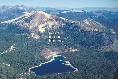
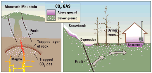
Mammoth Mountain, a young volcano in eastern California, sits on the southwest rim of Long Valley Caldera. In 1994, scientists detected high concentrations of CO2 gas in the soil on Mammoth Mountain. This invisible gas, seeping from beneath the volcano, is killing trees on the sides of the mountain and can pose a threat to humans. Recent measurements indicate that the total rate of CO2 gas emission at Mammoth Mountain is close to 300 tons per day. CO2 gas seeping from the ground at Mammoth Mountain is likely derived from magma (molten rock) beneath the volcano. In 1989, rising magma may have opened cracks, allowing large amounts of trapped CO2 gas to leak upward along faults. High concentrations of CO2 in soil can kill the roots of trees. CO2 gas is heavier than air, and when it leaks from the soil, it can collect in snowbanks, depressions- http://pubs.usgs.gov/fs/fs172-96/ |
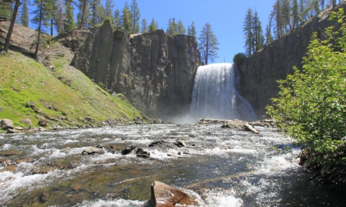
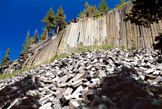
Between 200 and 100 KA, trachybasalt was erupted southwest of the caldera rim. The lava ponded behind a ridge of glacial deposits and cooled to produce spectacular columns. The basalt columns can be viewed at Devils Postpile National Monument - http://volcano.oregonstate.edu/vwdocs/volc_images/north_america/california/long_valley.html. |
Devils Postpile National Monument |
Obsidian Flow, a large circular-shaped lava flow, is part of the Mono-Inyo Chain- http://thewatchers.adorraeli.com/2012/02/12/new-volcano-observatory-in-california-to-monitor-dozens-of-potentially-threating-volcanoes/ |
Mono Lake Volcanic Field, шлаковый конус, 2121 (м). ѕоследнее извержение-1790 год. In eastern California, along the western edge of the Great BasinЧone of North AmericaТs four largest desertsЧsits Mono Lake. This salty remnant of a wetter era resides in a landscape of geologically young and potentially active volcanoes. (Credit: NASA Earth Observatory)- http://thewatchers.adorraeli.com/2012/02/12/new-volcano-observatory-in-california-to-monitor-dozens-of-potentially-threating-volcanoes/ Mono-Inyo Craters -http://en.wikipedia.org/wiki/Mono%E2%80%93Inyo_Craters |
Mono-Inyo Craters -http://en.wikipedia.org/wiki/Mono%E2%80%93Inyo_Craters |
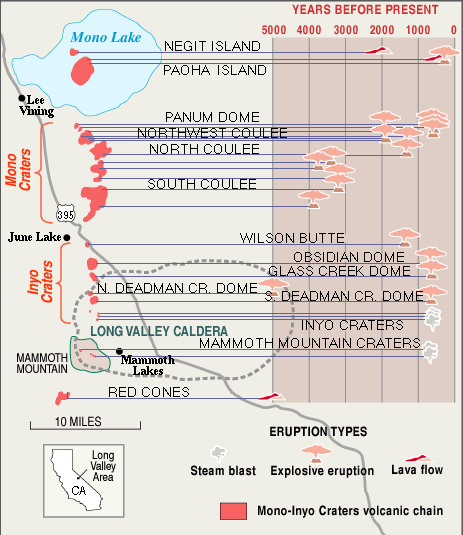
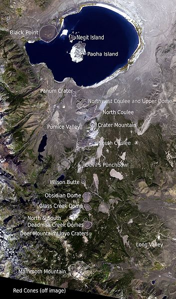
The Mono Craters form an arc of overlapping lava domes and flows.The Mono Craters are a 17 km chain of at least 27 volcanic domes, three large glass flows called coulees and various explosion pits and other associated volcanic features. The domes of the chain lie on a roughly northЦsouth-trending arc that is concave to the west and located south of Mono Lake. The highest of the Mono Craters domes is Crater Mountain (elevation 2,796 m), which rises 730 m)above Pumice Valley to the west. Associated volcanic features are located in Mono Lake (Paoha and Negit Islands) and on its north shore (Black Point). The coulees cluster north and south of the overlapping chain of domes. Craters exist at the top of most domes and on flat land south of them.The Mono-Inyo Craters are a 29-km long chain of silicic lava domes, lava flows, and explosion craters found along the eastern side of the Sierra Nevada range between Mono Lake and Long Valley Caldera. Mono Craters comprise the northern portion of the chain and form an arcuate, 17-km (10.5 km) long group of 30 or more dike-fed eruption centers. Explosive eruptions at Mono Craters began more than 50,000 years ago from now-buried vents, but almost all of the exposed domes and flows are of Holocene age. The Inyo Craters are a 12-km long chain of volcanic features similar to the northern-lying Mono Craters. The latest eruptions at Mono-Inyo Craters took place about 600 years ago when explosive eruptions and lava flows produced tephra deposits and obsidian lava domes.Location: California, Mono County. Elevation: 2,629 (m). Volcano type: lava domes. Composition: rhyolite. Most recent eruption: 600 years ago -http://volcanoes.usgs.gov/volcanoes/mono_inyo_craters/ |
The MonoЦInyo Craters is a chain. Mono Lake Volcanic Field forms the northernmost part of the chain and consists of two volcanic islands in the lake and one cinder cone volcano on its northwest shore. Most of the Mono Craters, which make up the bulk of the northern part of the MonoЦInyo chain, are phreatic (steam explosion) volcanoes that have since been either plugged or over-topped by rhyolite domes and lava flows. The Inyo Craters form much of the southern part of the chain and consist of phreatic explosion pits, and rhyolitic lava flows and domes. The southernmost part of the chain consists of fumaroles and explosion pits on Mammoth Mountain and a set of cinder cones south of the mountain; the latter are called the Red Cones.Eruptions along the narrow fissure system under the chain began in the west moat of Long Valley Caldera 400 to 60 KA. Mammoth Mountain was formed during this period. Multiple eruptions from 40,000 to 600 years ago created the Mono Craters and eruptions 5,000 to 500 years ago formed the Inyo Craters. Lava flows 5,000 years ago built the Red Cones, and explosion pits on Mammoth Mountain were excavated in the last 1,000 years. Uplift of Paoha Island in Mono Lake about 250 years ago is the most recent activity. These eruptions most likely originated from small magma bodies rather than from a single, large magma chamber like the one that produced the massive Long Valley Caldera eruption 760,000 years ago. During the past 3,000 years, eruptions have occurred every 250 to 700 years. In 1980, a series of earthquakes and uplift within and south of Long Valley Caldera indicated renewed activity in the area. Obsidian was collected by Mono Paiutes.. Mono Mills processed timber felled on or near the volcanoes for the nearby boomtown Bodie in the late 19th to early 20th centuries - http://en.wikipedia.org/wiki/Mono%E2%80%93Inyo_Craters |
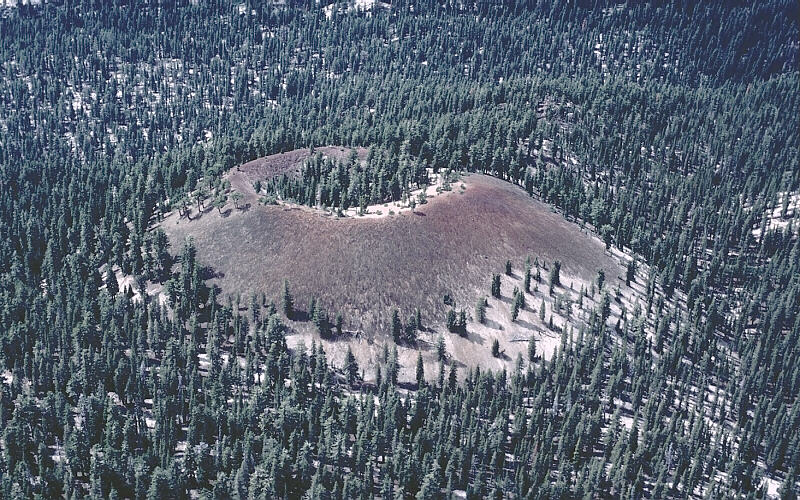
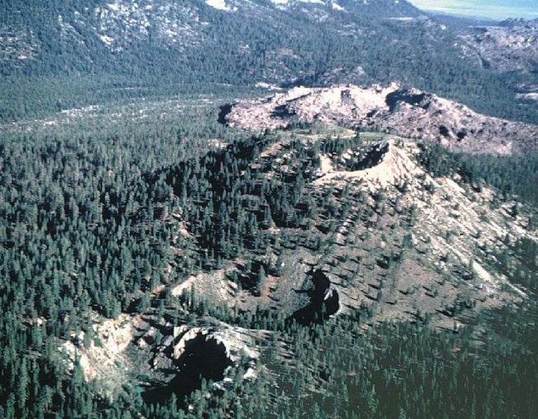
The Inyo Craters are a set of explosion pits and flows of glassy lava.The two southernmost Inyo Craters are open pits in a forested area that are about 180 m across and 30 to 60 m deep, each with small ponds covering their floors. A half kilometer north of these is another Inyo Craters explosion pit on top of Deer Mountain. Farther north of these craters are five lava domes, including Deadman Creek Dome, Glass Creek Dome, Obsidian Dome, and Wilson Butte. These domes are composed of gray rhyolite, frothy pumice, and black obsidian. The MonoЦInyo Craters volcanic chain extends into Long Valley Caldera but is not related to the caldera''s volcanism- http://en.wikipedia.org/wiki/Mono%E2%80%93Inyo_Craters |
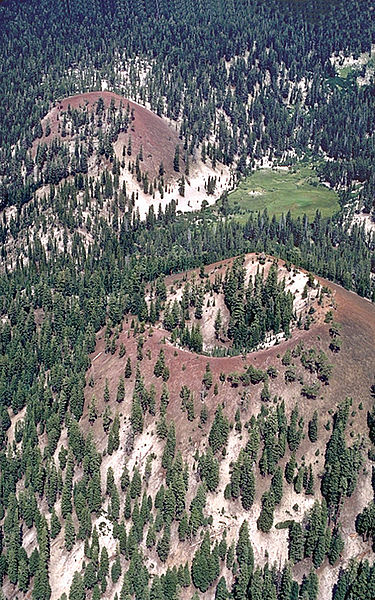
The Red Cones are cinder cones at the south end of the MonoЦInyo volcanic system. South of the Inyo Craters proper are other features related to the dike system responsible for creating the craters, volcanoes and lava flows. These include a northЦsouth trend of fault scarps up to 6 m high and pull-apart cracks or fissures in the earth. These fissures are not technically faults because little or no vertical or horizontal movement has occurred along them. Most notable among these is "Earthquake Fault", a fissure up to 3 m wide that cuts 18 to 21 m into glassy rhyolite lava flows. The fissure was formed by stretching induced by the intrusion of the Inyo dike. Stairs to the bottom of the fissure were removed after being damaged by earthquakes in 1980. Several MonoЦInyo-related explosion pits are on Mammoth Mountain. The Red Cones, south of Mammoth Mountain, are basaltic cinder cones and are the southernmost part of the MonoЦInyo Craters volcanic chain - http://en.wikipedia.org/wiki/Mono%E2%80%93Inyo_Craters |
Panum Crater is the northernmost volcano in the sequence and is a good example of both a tuff ring and a rhyolite dome. Its structure is twofold; an outer tuff ring (forming a classic crater) and an inner plug, or dome of rhyolite, pumice and obsidian created from lavas. In this case, heat from the magma feeding Panum flashed groundwater to steam to create the tuff ring before lava reached the surface. Other Mono Craters also were formed in this manner, but their plug domes grew larger than their tuff ring craters. The domes have steep sides and are flanked by slopes of scree consisting of large angular and glass-rich rocks. Devil''s Punch Bowl, located south of the main dome complex, stopped forming at an earlier stage of development. It is a 370 m wide and 43 m deep explosion pit with a much smaller glass dome on its floor - http://en.wikipedia.org/wiki/Mono%E2%80%93Inyo_Craters |
The large North and South Coulee and the smaller Northwest Coulee consist of obsidian-rich rhyolite. They were formed from slow-moving lava that had a thin and brittle crust. Once the flow stopped, it formed steep sided tongues of sharp and angular rock that are typically 60 to 90 m thick and have scree piles along their base. South Coulee is 3.6 km long, 01.2 km wide and has a volume of 0.4 km3; making it the largest Mono Craters coulee in volume. South Coulee originates from the crest of the Mono Domes, about 5 km from the southern end, flows down its east and west flanks and terminates at its foot. North Coulee is nearly as large, flows mostly to the east and terminates in a divided pair of lobes. Northwest Coulee is located northwest of North Coulee and was intruded by Upper Dome after the coulee solidified.[ Permanent pockets of ice from snowmelt have been found 23 to 45 m inside the coulees and domes -http://en.wikipedia.org/wiki/Mono%E2%80%93Inyo_Craters |
The creation of Paoha Island Eruptions of silica-poor rhyolite from 5,000 to 500 years ago created the Inyo Craters. The most recent activity occurred just a few years after the Mono Crater eruptions, and was caused by a dike of similar composition. The dike eventually became 11 km long and up 10 m wide. The ground above the dike was significantly cracked and faulted.Explosive eruptions later emanated from three separate vents.[ Pieces of molten and solid rock were ejected, small craters were formed, and a tall eruption column rose above the vents. Pumice and ash covered an extensive area downwind, and about 2.5 cm of tephra was deposited .A pyroclastic flow from South Deadman vent traveled about 6 km.Some of the open pits were filled with thick and slow-moving lava to form the South Deadman Creek, Glass Creek and Obsidian Flow domes. Others, such as the Inyo Crater Lakes near Deer Mountain, remained open and were later partially filled with water. Smaller explosion pits on the north side of Mammoth Mountain were also formed at this time. In the past 6,000 years, approximately 0.8 km3 of magma has been erupted from the Inyo part of the chain.The last recorded volcanic activity in the chain was at Mono Lake between the years 1720 and 1850. An intrusion of magma below the lake pushed lakebed sediments upward to form Paoha Island. Exposed rhyolite is on the north part of the island, and a group of seven dacite cinder cones and a lava flow are on the northeastern corner Steam rose in columns hundreds of feet high (tens of meters) from Hot Spring Cove on the island and the spring water was 66 oC in the early 1880s.-http://en.wikipedia.org/wiki/Mono%E2%80%93Inyo_Craters |
Mammoth Mountain from the north (Minaret Summit). Mammoth Mountain, лавовый купол, 3369 (м). ѕоследнее извержение 1260 год - Long Valley Caldera, California Mammoth Mountain and Mammoth Lakes Inyo Craters and Mono Domes. Mammoth Mountain was formed in a series of eruptions that ended 57,000 years ago. However, Mammoth still produces hazardous volcanic gases that kill trees and caused ski patroller fatalities in 2006 Mammoth Mountain lies on the South end of the Mono-Inyo chain of volcanic craters. Mammoth Mountain is also on the southwestern edge of Long Valley Caldera, a large area that subsided after an enormous eruption 760,000 years ago. The Mammoth Mountain magmatic system is considered distinct from that of Long Valley caldera and Inyo Craters.The volcano was formed from a long series of eruptions that started about 110,000 years ago and lasted to approximately 57,000 years ago. During this time, massive dacite eruptions occurred roughly every 5000 years. The volcano is still active with minor eruptions, the largest of which was a minor phreatic (steam) eruption 700 years ago. Mammoth Mountain is composed primarily of dacite and rhyolite, some of which have been altered by hydrothermal activity from fumaroles (steam vents) - http://en.wikipedia.org/wiki/Mammoth_Mountain, http://vulcan.wr.usgs.gov/Volcanoes/LongValley/framework.html |
Mammoth Mountain . Carbon dioxide has killed a large area of trees http://en.wikipedia.org/wiki/Mammoth_Mountain |
|
The Holocene Coso volcanic field, located east of the Sierra Nevada Range at the western edge of the Basin and Range province consists of Pliocene to Quaternary rhyolitic lava domes and basaltic cinder cones covering a 400 sq km area. Much of the volcanic field lies within the China Lake Naval Weapons Center. Active fumaroles and thermal springs are present in an area that is a producing geothermal field. The youngest eruptions were chemically bimodal, forming basaltic lava flows along with 38 rhyolitic lava flows and domes, most with youthful, constructional forms. The latest dated eruption formed the Volcano Peak basaltic cinder cone and lava flow and was Potassium-Argon dated at 39,000 +/- 33,000 years ago. Although most activity ended during the late Pleistocene, the youngest lava dome may be of Holocene age based on geomorphological evidence (Monastero 1998, pers. comm.)- http://www.volcano.si.edu/world/volcano.cfm?vnum=1203-18- |
Bubbling mudpots are abundant in the Coso Hot Springs on the eastern margin of the Coso volcanic field. The hot springs occur along faults at the margins of a horst capped by rhyolitic rocks and are associated with fumaroles, mudpots, and widespread areas of hydrothermally altered ground.Photo by Paul Kimberly, 1997 (Smithsonian Institution)- http://www.volcano.si.edu/world/volcano.cfm?vnum=1203-18-&volpage=photos |
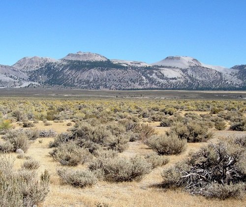
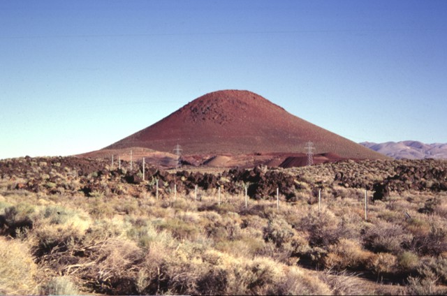
Red Cone, a basaltic cinder cone at the western margin of the Coso volcanic field, is a prominent landmark visible from Highway 395, which follows the eastern margin of the Sierra Nevada Range. The late-Pleistocene cinder cone is the largest of a group of isolated cones along the valley floor. An area of more concentrated young basaltic cones and lava flows occurs to the SE along the crest of the volcanic horst forming the Coso Range.Photo by Paul Kimberly, 1997 (Smithsonian Institution). |
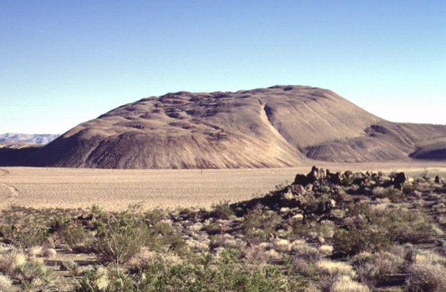
The Sugarloaf Mountain lava dome and associated lava flows, seen here from the west, is the largest of 38 rhyolitic lava domes of the Coso volcanic field, rising 300 m above its base. The high-silica rhyolite of Sugarloaf Mountain contains localized areas of obsidian that were used as a source of arrowheads for native Americans. The dome has been dated at about 41,000 +/- 21,000 years and is one of the youngest volcanic vents at Coso.Photo by Lee Siebert, 1997 (Smithsonian Institution) |
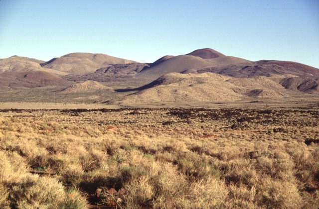
A series of basaltic cinder cones and related lava flows at the southern end of the Coso volcanic field form some of the youngest volcanic products at Coso. The cones and flows are concentrated along the south edge of a NE-trending horst that is capped by rhyolitic lava domes and flows. Many of the flows, such as the one left of center, are intracanyon flows that traveled down existing drainages.Photo by Lee Siebert, 1997 (Smithsonian Institution). |
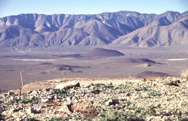
Red Cone (center) is the largest of a group of isolated basaltic scoria cones and lava flows on the floor of the Rose Valley in the western part of the Coso volcanic field. The late-Pleistocene scoria cone is seen here from the NE, with the towering fault scarp of the Sierra Nevada Range in the background. Highway 395 traverses Rose Valley between the cone and the Sierras. Photo by Lee Siebert, 1997 (Smithsonian Institution) |
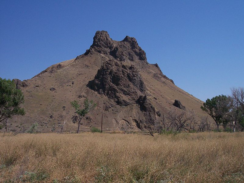
Malheur Butte is an extinct volcano located in Malheur County, Oregon. Malheur Butte is an extinct volcano located in Malheur County, Oregon. Between 20 and 15 million years ago, the region from north-central Washington to northeastern California experienced a series of volcanic eruptions and basalt lava floods that covered thousands of square miles. These ancient lava floods often dammed streams, creating lakes and swamps that may have lasted for millions of years before filling with sediment or draining as erosion slowly lowered their outlets. The western Snake River plain contained many such lakes, and geologists believe that between 8 and 2 million years ago, "Lake Idaho" covered much of central eastern Oregon. Sediment deposited in this lake once covered Malheur Butte, and during the last 2 million years the Malheur River and other eroding forces slowly exposed and shaped today''s landmark.Although Malheur Butte has been inactive for millions of years, Malheur County is still alive with geothermal activity in the form of hot springs. Today, Oregon Trail Mushroom uses geothermal energy at their processing plant in Vale, and efforts are being made to further utilize this unique energy source throughout the country. http://en.wikipedia.org/wiki/Malheur_Butte |
|


C http://thewatchers.adorraeli.com/2012/02/12/new-volcano-observatory-in-california-to-monitor-dozens-of-potentially-threating-volcanoes/
More than 500 volcanic vents have been identified in the State of California. At least 76 of these vents have erupted, some repeatedly, during the last 10KA.
Silicic vents , 10 KA, Many silicic lava flows erupted at numerous vents between 1,000 years and about 500 years ago; possible flows younger than 500 years B.P. Many silicic domes erupted at numerous vents between 10,000 years ago and about 500 years ago. Many silicic tephras erupted from numerous vents; volumes ranged from more than 0.02 cubic kilometers to less than 0.2 cubic kilometers. Many pyroclastic flows from numerous vents. Some have flowed 10-15 kilometers from vents. Many phreatic, phreatomagmatic and pyroclastic surge events have occurred at numerous vents. Small debris flows have originated at several vents. A series of explosive magmatic and phreatic eruptions and emplacement of lava flows occurred at several vents at the Inyo volcanoes about 550 years ago. Small- to moderate- volume silicic pyroclastic eruptions that will form pyroclastic flows and small to moderate volumes of tephra. (Miller, 1983; 1985; Miller and others, 1982; Wood, 1983)- http://vulcan.wr.usgs.gov/Volcanoes/California/Hazards/Bulletin1847/table_holocene_volcanoes.html
The Salton Buttes comprise five small rhyolite domes extruded onto Quaternary sediments of the Colorado River delta. Rock Hill and Mullet Island are simple domes; Mullet Island is notable for its symmetrical "onion-skin" pattern of foliation, attributed to endogenous growth. Obsidian Butte consists of a central dome surrounded on all sides by a single flow. Red Island is made up of two domes, each mantled by subaqueous pyroclastic deposits. Xenoliths of basalt, partly melted granite, deltaic sediments, and their hydrothermally metamorphosed equivalents are common in the rhyolites of Obsidian Butte and Red Island. All the domes exhibit wave-cut benches carved during various stands of pre-historic Lake Cahuilla, and have been partly buried by lacustrine and aeolian deposits
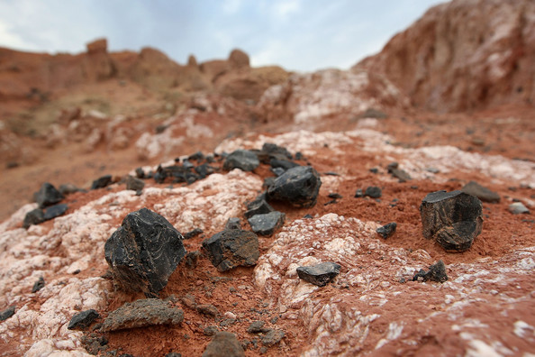
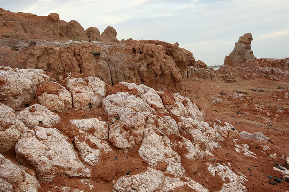
Salton Sea - Obsidian Butte consists of a central dome of rhyolite surrounded on all sides by a single rhyolite flow. The dome is approximately 250 meters in diameter and rises some 30 meters above the adjacent alluvial surface of the Imperial Valley. The flow stands 20 to 25 meters below the crest of the central dome. The contact between the flow and the dome is exposed on the northwest side of the dome as a steeply dipping breccia zone. The central dome of Obsidian Butte is composed of medium-gray to dark-gray rhyolite that is locally pumiceous and (or) spherulitic. Flow foliation, although variable and erratic in detail, defines a crudely domal pattern. The flow around Obsidian Butte consists of rhyolitic obsidian covered by a discontinuous mantle of brown-weathering, light-gray pumice. Numerous spines of black obsidian protrude upward and through the blocky pumice mantle. Low ridges and troughs rudely concentric to the central dome indicate that the flow spread radially from a vent located where the dome now rises. At the perimeter of this flow, there is a discontinuous ring of ten obsidian hills that rise as much as 15 meters above the surrounding alluvium.
Overlying the eastern part of the flow and lapping onto Obsidian Butte itself is a thick deposit of gravel, much of which has been removed by quarrying (Chesterman, 1956). A bulldozer cut just east of Obsidian Butte exposed 10 meters of gravel and sand composed almost entirely or rounded clasts of pumice and ash. This material was derived from the pumice mantle of the flow and from pyroclastic eruptions that probably preceded extrusion of the flow. The pumice clasts were rounded by wave action of Lake Cahuilla and were concentrated on the eastern, lee side of the volcano. At least seven wave-cut benches can be identified on the east slope of Obisdian Butte. Thick rinds of tufa on obsidian surfaces throughout the flow also attest to covering of Obsidian Butte by lake waters in the past.
http://vulcan.wr.usgs.gov/Volcanoes/California/SaltonButtes/description_salton_buttes.html
http://vulcanism.ru/120311.html
http://volcanoes.usgs.gov/observatories/calvo/
Summary of Holocene eruptive activity http://vulcan.wr.usgs.gov/Volcanoes/California/Hazards/Bulletin1847/table_holocene_volcanoes.html
http://www.volcano.si.edu/world/region.cfm?rnum=12&rpage=highlights volcanoes
http://www.volcano.si.edu/world/region.cfm?rnum=1203 california volcanoes
see also http://plate-tectonic.narod.ru/banrphotoalbum.html Fossile falls
http://www.zacktravel.com/amazing-mono-lake/
http://www.owensvalleyhistory.com/casa_diablo/page75.html Long Valley caldera
http://plate-tectonic.narod.ru/ubehebephotoalbum.html Kратер гидравлического взрыва Ubehebe
California volcanoes
California Volcanoes and Volcanics
Active and Potentially Active Volcanoes in California
New volcano observatory opens in California
MonoЦInyo Craters