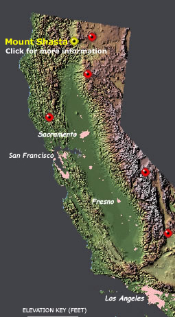
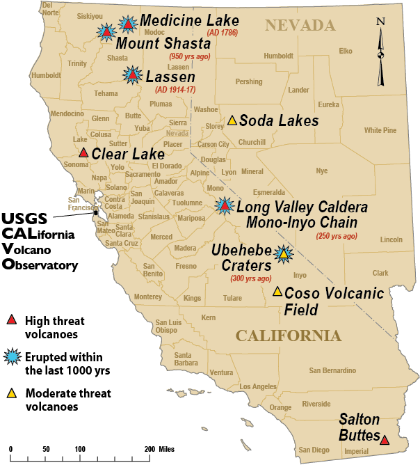
 | California Volcanoes |
http://nationalatlas.gov/dynamic/dyn_vol-ca.html |
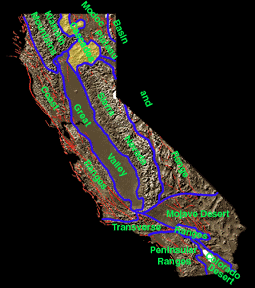
California''s Geomorphic Provinces -http://www.goldengatephoto.com/geotours/cgp8.html |
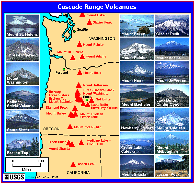
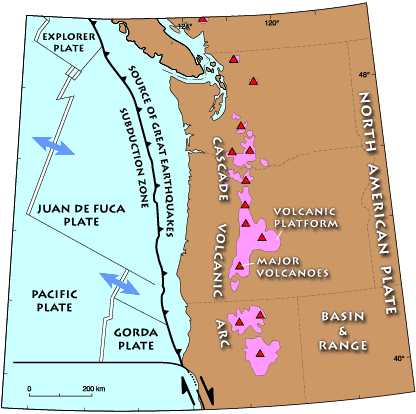
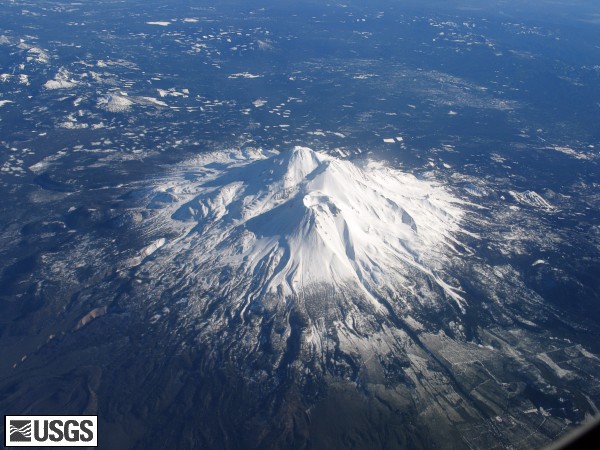
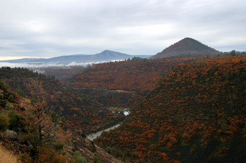
The Cascade Range is a string of volcanic centers extending from Northern California into southern British Columbia, Canada. In California, the Cascades include Lassen Peak, Mount Shasta, and the Medicine Lake shield volcano. The Medicine Lake shield volcano produced a glassy obsidian flow in its most recent eruption about 900 years ago. Over the last 4,500 years, Mount Shasta has erupted on average every 600 years. It last erupted about 200 years ago. Mount Shasta is also one of the most prominent topographic features on the planet, rising 3,350 meters above the plain below. Lassen Peak last erupted in 1914-1917! The only other volcano in the continental United States to have erupted in the 20th century is Mount St. Helens in Washington- http://www.goldengatephoto.com/geotours/cgp8.html |
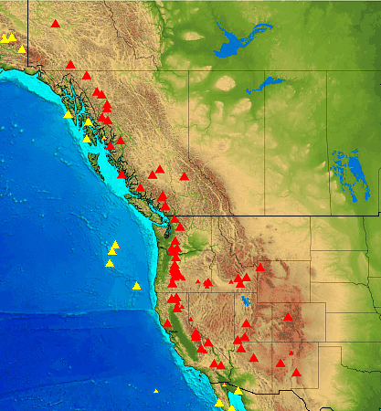
Large red triangles show volcanoes with known or inferred Holocene eruptions; small red triangles mark volcanoes with possible, but uncertain Holocene eruptions or Pleistocene volcanoes with major thermal activity. Yellow triangles distinguish volcanoes of other regions- http://www.volcano.si.edu/world/region.cfm?rnum=12 |
Pacific Mountain System - Cascades volcanic province- http://www.nature.nps.gov/Geology/usgsnps/province/cascade1.html |
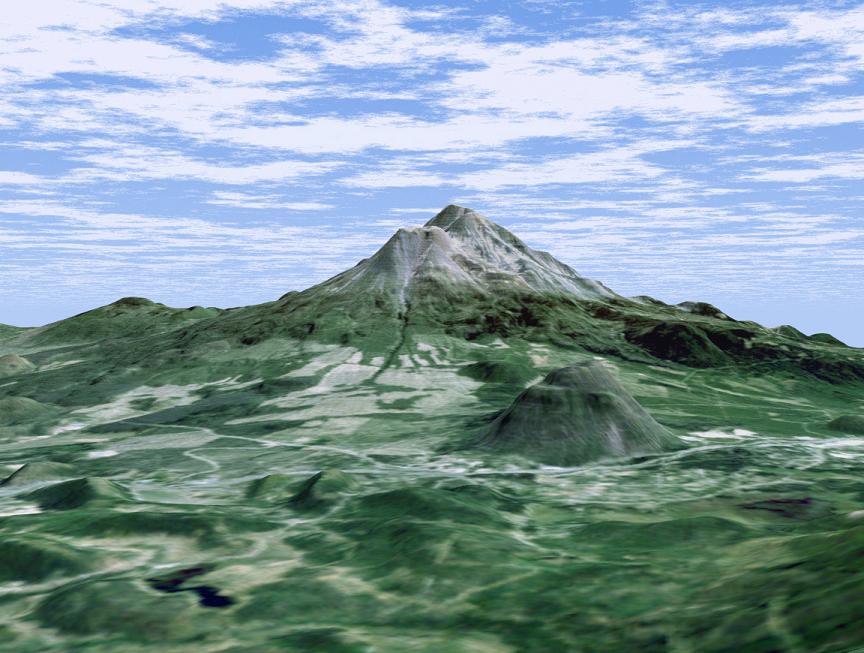
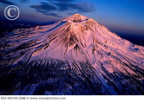
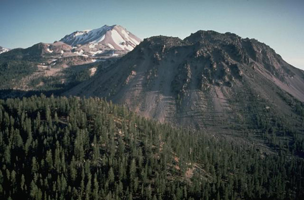
At more than 4,300 meters Mount Shasta is California’s tallest volcano and part of the Cascade chain of volcanoes extending south from Washington. This computer-generated perspective viewed from the west also includes Shastina, a slightly smaller volcanic cone left of Shasta’s summit and Black Butte, another volcano in the right foreground-http://earthobservatory.nasa.gov/IOTD/view.php?id=2143 |
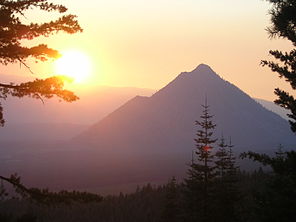
Black Butte is a cluster of overlapping dacite lava domes in a butte, a parasitic satellite cone of Mount Shasta. The highway crosses a 1,192 m pass, Black Butte Summit, at the western base of the lava domes. The lava domes were extruded at the foot of the cone of Shastina following the period of its major eruptions about 9–10 KA -http://en.wikipedia.org/wiki/Black_Butte_(Siskiyou_County,_California) |
Карта вулкана Шаста. Shasta, стратовулкан, 4317 (м). Последнее извержение 1786 год- http://vulcanism.ru/120301.html |
Mount Shasta, California - http://vulcan.wr.usgs.gov/Volcanoes/Shasta/images.html The Cascade Range is a string of volcanic centers extending from Northern California into southern British Columbia, Canada. In California, the Cascades include Lassen Peak, Mount Shasta, and the Medicine Lake shield volcano. The Medicine Lake shield volcano produced a glassy obsidian flow in its most recent eruption about 900 years ago. Over the last 4,500 years, Mount Shasta has erupted on average every 600 years. It last erupted about 200 years ago. Mount Shasta is also one of the most prominent topographic features on the planet, rising 11,000 feet (3,350 meters) above the plain below. Lassen Peak last erupted in 1914-1917! The only other volcano in the continental United States to have erupted in the 20th century is Mount St. Helens in Washington -http://www.goldengatephoto.com/geotours/cgp8.html |
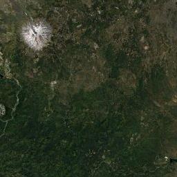
Mt. Shasta is a majestic, steep-sided stratovolcano located about 97 km north of Redding along the I-5 corridor in Northern California. It is the most voluminous of all the Cascade Range volcanoes in the shadow of its 4,317 m high snow- and ice-clad edifice, which also holds the headwaters of the Upper Sacramento River. Mount Shasta began forming on the remnants of an older, similar volcano that collapsed 300-500 KA. The collapse spawned one of the largest landslides known on Earth, covering more than 440 km2 of Shasta Valley to the northeast. Activity over the last 300KY includes long intervals of quiet interrupted by shorter spans of frequent eruptions. Eruptions at about 11KA built Black Butte and Shastina on the western flanks of Mount Shasta. In the last few millennia, smaller eruptions have broken out at the volcano’s summit and from vents on its upper east flank. Preliminary work indicates the volcano erupted in the past 200-300 years and historic reports of an eruption plume witnessed from sea in 1786 may or may not be accurate. Hot springs and volcanic gases still seep from the summit indicating a still-hot system and relatively young. Non-volcanic shedding of young volcanic rock and ash from Mount Shasta’s steep slopes occurs during heavy rainfall or glacial floods. In the last 1,000 years, more than 70 mudflows have inundated stream channels. The record of eruptions over the last 10,000 years suggests that, on average, at least one eruption occurs every 800 to 600 years at Mt Shasta.Location: California, Siskiyou County. Composition: andesite, dacite. Most recent eruption: 200-300 years ago -http://volcanoes.usgs.gov/volcanoes/mount_shasta/ |
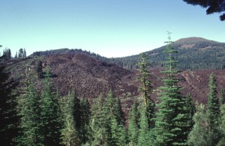
Small hills NNE of Mt. Shasta are hummockslide 380,000 and 300,000 years ago. This view is from the top of Gregory Mountain, located about 40 km from the summit of the volcano. The prominent cone on the right skyline is Black Butte, a collection of four overlapping lava domes that were erupted about 9,500 years ago. (Credit: USGS)- http://thewatchers.adorraeli.com/2012/02/12/new-volcano-observatory-in-california-to-monitor-dozens-of-potentially-threating-volcanoes/ |
USGS Photograph taken September 22, 1982, by Harry Glicken |
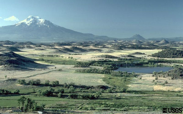
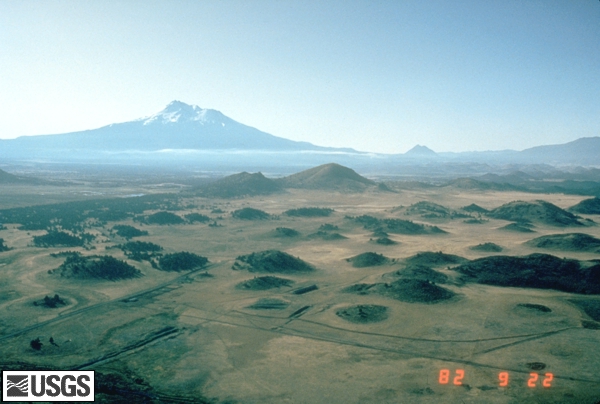
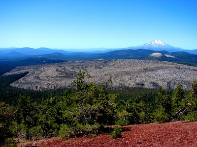
Volcano Shasta and Volcano Glass Mountain from Medicine Lake - http://www.realmagick.com/medicine-lake-volcano-glass-mountain/ |
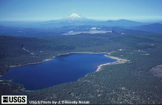
Medicine Lake, CA is located about 30 miles Northeast of Mt. Shasta.The lake sits in the caldera of an ancient volcano called Medicine Lake Volcano. The most recent eruptions took place about 1,000 years ago on the east side of the rim (called Glass Mountain). Its waters are known for being cold and amazingly clear.Medicine Lake has special spiritual significance for local Indian tribes, who frequently use the lake for ceremonies - http://allthingsshasta.com/wordpress/?p=1242 |
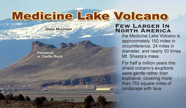
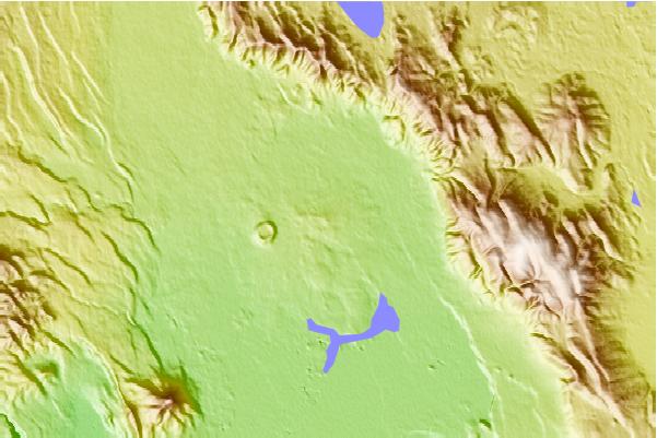
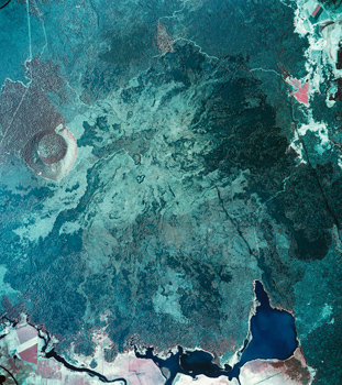
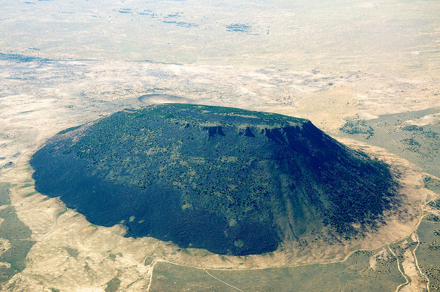
Medicine Lake Volcano is a shield volcano in far-northern California, USA. It is associated with the Cascade Range of stratovolcanoes. The Cascade Range formed by subduction of the Juan de Fuca Plate underneath the North American Plate in northern California, Oregon, Washington State, and southwestern British Columbia. Quite a variety of material has been erupted from the Medicine Lake Volcano, including basalts, andesites, rhyolites, dacites, obsidian, and pumice-http://www1.newark.ohio-state.edu/Professional/OSU/Faculty/jstjohn/Volcano%20stuff/Medicine-Lake-Volcano.htm, http://vulcan.wr.usgs.gov/Volcanoes/MedicineLake/Graphics/framework.html Medicine Lake volcano is situated just east of the Cascade Volcanic Arc axis in northern California’s high desert 55 km, northeast of Mount Shasta. This shield-shaped volcano together with its surrounding apron of lavas covers a total area of about 2,200 km2, extending approximately 80 km north-south and 50 km east-west. A shallow, but wide (7x12 km) caldera basin containing its namesake lake is located at the summit of the volcano. Medicine Lake volcano has had intermittent eruptive periods over the last half-million years producing mostly basalt to andesite lava flows and cinder cones with occasional dacite to rhyolite lava flows and tephras. The most recent volcanic activity occurred about 950 years ago and formed Glass Mountain, a 1 km3 dacite and rhyolite obsidian flow that erupted just outside the eastern caldera rim. Lava Beds National Monument is located on the northern flank of Medicine Lake volcano and encompasses mostly basaltic lavas that host spectacular lava-tube caves and form other well-preserved young volcanic features. Location: California, Siskiyou and Modoc Counties. Volcano type: composite. Composition: basalt to rhyolite. Most recent eruption: 950 years ago - http://volcanoes.usgs.gov/volcanoes/medicine_lake/ |
It lies within the volcanic caldera of the Medicine Lake shield . Medicine Lake, щитовой вулкан, 2412 (м). Последнее извержение 1080 год, радиоуглеродный метод- http://vulcanism.ru/120302.html, http://pubs.usgs.gov/sim/2927/sim2927_sheet1.pdf, http://www.sierranevadageotourism.org/content/medicine-lake-highlands/sieD6F3872DCE8DCA44A |
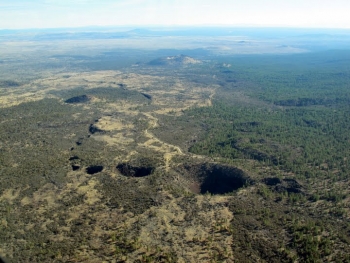
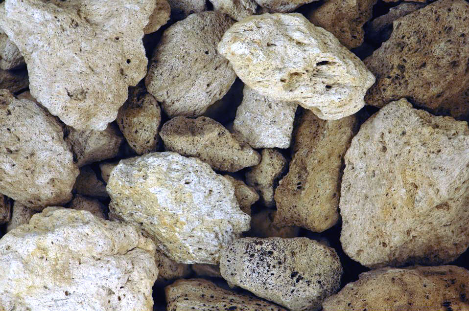
The rocks shown below are airfall pumice pieces from a ~1065 A.D. eruption at the Glass Mountain eruptive center, on the eastern side of Medicine Lake Volcano -airfall pumice pieces from ~1065 A.D. eruption of Medicine Lake Volcano. Pale-colored pumice at upper right is 2.7 cm long |
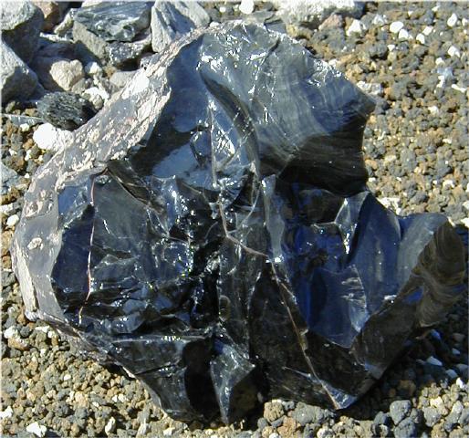
Medicine Lake Obsidian Flow The Medicine Lake obsidian flow formed about 900 years ago when a viscous rhyolitic lava oozed out of the Medicine Lake shield volcano like toothpaste and solidified into a mass of volcanic glass. The flowing and cooling action resulted in the formation of the jagged blocks- http://www.goldengatephoto.com/westus/cacascade.html |
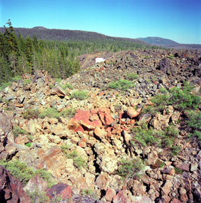
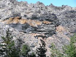
This is an obsidian outcropping at Glass Mountain on the Medicine Lake |
http://www.mountain-forecast.com/peaks/Medicine-Lake-Volcano |
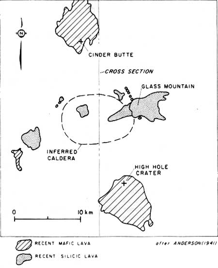
Map showing distribution of Holocene lavas of the Medicine Lake Highland- http://www.cr.nps.gov/history/online_books/geology/publications/circ/838/sec10.htm |
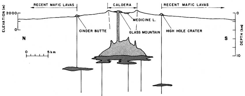
MECHANISM OF MAGMA MIXING AT GLASS MOUNTAIN, MEDICINE LAKE HIGHLAND VOLCANO CALIFORNIA - A north-south cross section through the center of the Medicine Lake Highland volcano (line of cross section shown in Figure 2), with major features projected onto the profile. Vertical exaggeration of surface topography is 2X. Silicic magma chamber is shown at depth discussed in text and intermediate in size between the minimum case, a small body at intersection of cone sheet caldera fractures (Heiken, 1978) and the maximum possible extent marked by position of flanking mafic vents. (click on image for an enlargement in a new window) http://www.cr.nps.gov/history/online_books/geology/publications/circ/838/sec10.htm |
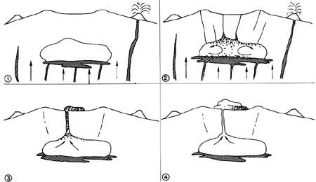
Probable eruption sequence at Glass Mountain. (1) Mafic magma intrudes shallow rhyolitic magma chamber and erupts nearby at High Hole Crater. (2) Vesiculation of chilled mafic magma forms foam which floats and mixes in the convecting chamber. (3) Vesiculation in chamber triggers eruption, which first taps hybrid dacite concentrated near roof of chamber. (4) Eruption continues with extrusion of rhyolite magma. Rhyolitic tephra which underlies Glass Mountain may have erupted early in this sequence, as an immediate response to intrusion of mafic magma into the chamber, before mixing was far advanced. Alternatively, low density of water-rich rhyolitic magma at the top of the chamber say have prevented further rise of foam-rich currents. so that a small rhyolitic cap remained near the chamber roof and erupted as tephra just before the hybrid dacite- http://www.cr.nps.gov/history/online_books/geology/publications/circ/838/sec10.htm |
The Modoc Plateau lies in the northeast corner of California as well as parts of Oregon and Nevada. It is a mile-high expanse of lava flows with cinder cones, juniper flats, pine forests, and seasonal lakes.[ The plateau is thought to have been formed approximately 25 MA. Nearly 400,000 ha of the Modoc National Forest lie on the plateau between the Medicine Lake Highlands in the west and the Warner Mountains in the east - http://en.wikipedia.org/wiki/Modoc_Plateau |
the Pit River as it flows through the Modoc Plateau |
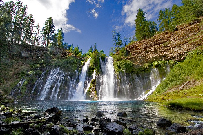
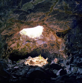
Burney Falls lava beds. The Modoc Plateau is a high plain built upon a thick accumulation of lava flows. Broken by scattered north-south faults, river streams, and volcanic cones, the lava flows have erupted episodically for at least 2 million years. At Lava Beds National Monument, lava flows from Mammoth Crater covered the area about 30 KA, forming most of the 400+ lava tubes in the monument. At Burney Falls, which lies near the Modoc Plateau/Cascade Range boundary, the river cascades past 39 meters of lava flows . Lava tubes are formed when certain types of lava (basalt) flow from a volcano. Just like at Kilauea in Hawai''i, this type of lava is hot (900oC). The edges of the flow cool quickly in the open air and sometimes slow down and solidify while the underlying lava, insulated from the air, continues to flow hot and fast. When the outpouring of lava ceases, and if the lava has an opening downstream, the lava can drain out, leaving a shell, the lava tube, behind. Some lava tubes form then collapse, leaving surface openings and troughs. Others are so well insulated, that seasonal and perennial ice is formed inside. Many branch and meander like a braided stream. The Lava Beds are part of a larger volcanic terrain called the Modoc Plateau. Spectacular waterfalls form where a river pours over the edge of one of the lava flows. The upper part of the cliff face is the 2 million year old Burney Basalt lava flow. The lower part of the cliff is composed of older tilted sedimentary rocks. Look closely and you will see the tilt of the beds through the cascading water. Note that the river forms the two main waterfalls on the right. The remainder of the cascade is from groundwater seeping out along a line of springs at the contact between the two rock units. The falls are 39 meters high.- http://www.burney-falls.com/ |
Obsidian from Modoc Platea |
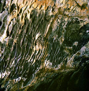
Lava beds. Blue Grotto Cave - The pale gray-blue walls, created by mineral coatings, surround this skylight - http://www.goldengatephoto.com/westus/lavabed.html |
Lava Beds. Multicolored Lava Stalactites, Hopkins Chocolate Cave - Discovered by E. L. Hopkins in 1892, this lava tube was named for the light brown coating of mud and minerals on its roof and walls. The lava stalactites (also called lavacicles or shark tooth stalactites) form on overhanging surfaces after the lava in the tube recedes and the lava coating the roof and walls hardens as it drips - http://www.goldengatephoto.com/geotours/cgp11.html |
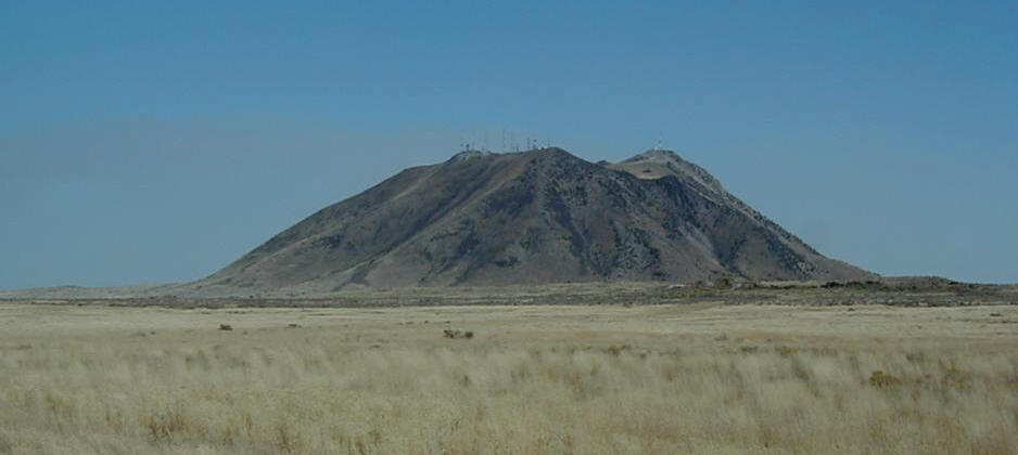
Brushy Butte, щитовой вулкан, 1174 (м)- http://vulcanism.ru/120303.html, http://www.mountain-forecast.com/peaks/Brushy-Butte |
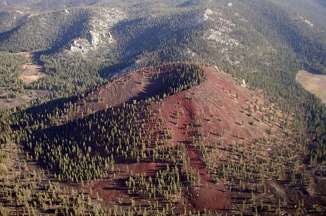
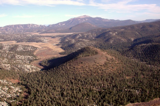
Brushy Butte forms a small shield complex immediately east of Timbered Crater, south-southeast of the Medicine Lake Highlands. The Brushy Butte complex has produced a broad apron of basaltic lava flows with fresh-looking flow features that extends preferentially down the regional gradient to the south as far as the Falls River valley. Soil development and revegetation suggested a Holocene age similar to that of Hat Creek flow to the south. The Hat Creek flow, however, has been dated at 18-30KA, and Brushy Butte and other young vents between Medicine Lake and Lassen volcanoes could be of latest Pleistocene or early Holocene age- http://volcanoes.usgs.gov/volcanoes/brushy_butte/ |
Brushy Butte - http://en.wikipedia.org/wiki/Brushy_Butte |
Twin Buttes, Idaho, EASTERN SNAKE RIVER PLAIN,consisting of Middle Butte (on the right) and Eastern Butte (on the left). Looking ~SE- http://www1.newark.ohio-state.edu/Professional/OSU/Faculty/jstjohn/IdahoGeology/Buttes.htm |
Middle Butte, Idaho |
Eastern Butte, Idaho a ~600 ky volcanic dome consisting principally of rhyolite lavas - http://www1.newark.ohio-state.edu/Professional/OSU/Faculty/jstjohn/IdahoGeology/Buttes.htm |
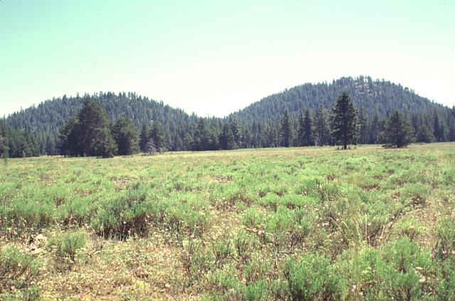
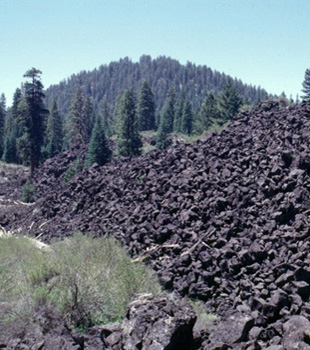
Twin Buttes, шлаковый конус, 1631 (м)- http://vulcanism.ru/120304.html,A group of cinder cones near Pleistocene Burney Mountain volcano, including Twin Buttes to the southeast, is considered to be of Holocene age (Miller, 1989). The cones are part of are area of extensive Quaternary volcanism north of the Lassen volcanic field. The youngest volcanism in this area has been assigned an age of latest Pleistocene or early Holocene. Blocky, partially unvegetated lava flows extend to the north from North and South Twin Buttes, which are located at the SE foot of the Burney Mountain lava dome complex.Location: California, Shasta County. Composition: basalt. Most recent eruption: Holocene - http://volcanoes.usgs.gov/volcanoes/twin_buttes/ |
A group of cinder cones near Pleistocene Burney Mountain volcano, including Twin Buttes to the southeast, is considered to be of Holocene age (Miller, 1989). The cones are part of are area of extensive Quaternary volcanism north of the Lassen volcanic field. The youngest volcanism in this area has been assigned an age of latest Pleistocene or early Holocene. Blocky, partially unvegetated lava flows extend to the north from North and South Twin Buttes, which are located at the SE foot of the Burney Mountain lava dome complex - http://volcanoes.usgs.gov/volcanoes/twin_buttes/ California,The Twin Buttes is a group of cinder cones located in the Cascade Mountain Range of Shasta County |
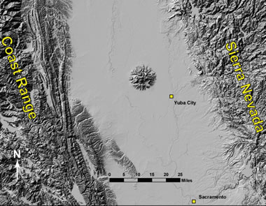
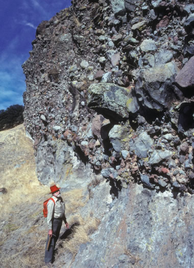
Sutter Buttes is 90 kilometers north of Sacramento. Sutter Buttes is an anomalous volcanic landform rising starkly from the flat plain of the Sacramento Valley. As interpreted by Howel Williams, rising magmas uplifted Cretaceous and Tertiary sediments, which quickly eroded. Explosive eruptions, extending perhaps 0.5 MA, accompanied the emplacement of viscous intrusions and extrusions at the center and periphery of the uplift. These pelean domes, which strongly uparched the intruded beds, are andesitic in the central core of Sutter Buttes, and are surrounded by a halo of dacitic to rhyolitic domes. There is no temporal succession of petrologic types, however. Geochemically, the andesites have much higher than normal values of K, Ba, and Sr. The coalescing central domes are surrounded by gently dipping andesitic sediments interpreted by Williams as waterlaid volcaniclastics produced by reworking of air-fall material ejected from vents in the center of the Buttes. This interpretation may be correct, but "water-laid volcanic deposits" at many other volcanoes have often been reinterpreted as primary base surge deposits. Sutter Buttes needs re-examination. It is often suggested that Sutter Buttes constitutes the southernmost Cascade volcano, and the feature does occur along the continental extension of the Mendocino Fracture Zone in a region which might have once covered a subduction zone. However, there are great differences in age and morphology compared to the large and young Cascade stratovolcanoes. Additionally, the lack of continuing volcanism at Sutter Buttes confounds analogues with the conventional Cascade volcanoes. http://vulcan.wr.usgs.gov/Volcanoes/California/SutterButtes/description_sutter_buttes.html |
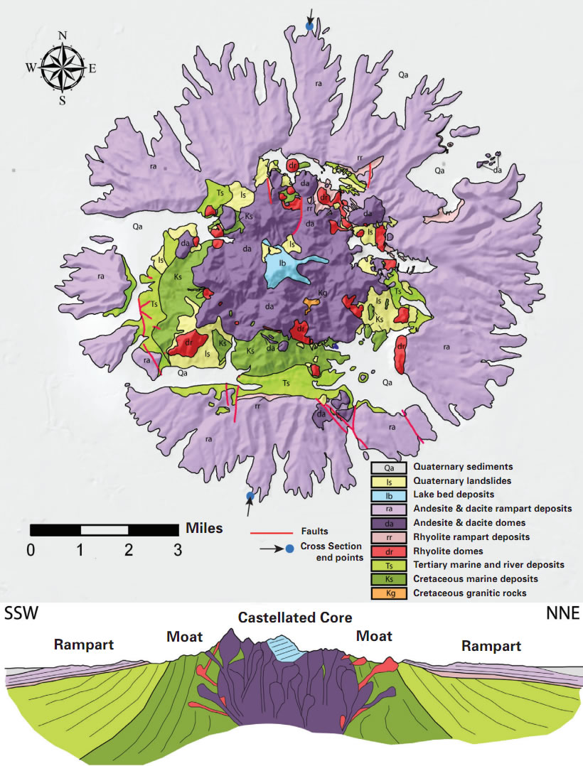
Geologic map and diagrammatic cross section of the Sutter Buttes. Geology compiled from Williams and Curtis (1977), Thamer (1961), and new mapping by Brian Hausback. The cross section is vertically exaggerated 3X to emphasize the topography- http://geology.com/usgs/sutter-buttes/ |
The first eruptions at Sutter Buttes occurred about 1.6 million years ago, in the early Pleistocene, when magma pushed upward through the thick pile of Sacramento Valley sediments. Some of the magma breached the surface to form extrusive domes in the rocky core of the Buttes. Explosive eruptions pulverized the extruding magma, depositing blocky fragments and volcanic ash that hardened into pyroclastic ("fire-broken") rocks. The first lavas to erupt were light-colored, often white, rhyolites-rocks rich in silica (SiO2) and alkalis (potassium and sodium) but poor in magnesium and iron. The extruding lavas were so viscous that they accumulated at the surface as thick, pasty blobs, or lava domes. After about 30,000 years, these rhyolites were followed by more voluminous eruptions of andesite and dacite, lavas lower in silica and higher in magnesium and iron than the earlier rhyolites. Forming much larger domes, the andesites and dacites are darker in color than the rhyolite, typically medium to dark gray, contain abundant large crystals, and are commonly oxidized (rusted) to brick red - http://geology.com/usgs/sutter-buttes/ |
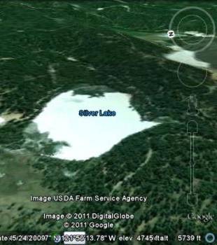
Silver Lake, шлаковый конус, 1535 (м)- http://vulcanism.ru/120305.html. Lava flows from two isolated cinder cones northwest of Lassen Peak blocked drainages, forming three small lakes. The cones lie southwest of Burney Mountain and west-northwest of Magee Peak. Lava flows from the Silver Lake cinder cone formed Silver Lake northeast of the cone and crescent-shaped Author Lake to the east and traveled 3.5 km (2.2 mi) to the southwest. The crater of Silver Lake cone is open to the southwest. The flat-topped Buckhorn Lake cinder cone to the southeast of Silver Lake dammed up Buckhorn Lake, northeast of the cone, and produced a lava flow that traveled 3.5 km (2.2 mi) to the southwest. These basaltic cones are of possible Holocene age, but lie outside the area of glaciation at Lassen and their age is not known with certainty.Location: California, Shasta County. Composition: basalt. Most recent eruption: Holocene - http://volcanoes.usgs.gov/volcanoes/silver_lake/ |
Tumble Buttes, шлаковый конус, 2191 (м). A line of cinder cones along a north-northwest- to south-southeast-trending fissure has produced a series of youthful-looking lava flows. The most prominent of these is Devils Rock Garden, a thick, blocky andesitic lava flow complex that extends to the south from Tumble Buttes. Bear Wallow Butte (dated at 35 ka), the source of unvegetated lava flows on its eastern and western flanks, lies at the southern end of the chain. At the northern end is Eiler Butte, constructed on a topographic high, which has also produced blocky lava flows. Miller (1989) mapped Tumble Buttes as Holocene. The Devils Rock Garden lava flow erupted from Tumble Butte south is the youngest in the area. It blocked glacial outwash channels and overlies glacial gravels and thus is younger than about 15KA, but not necessarily Holocene.Location: California, Shasta County Composition: basalt Most recent eruption: Holocene - http://volcanoes.usgs.gov/volcanoes/tumble_buttes/ |
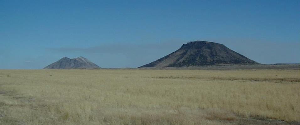
Chaos Crags in the foreground and Lassen Peak in the background are large lava dome complexes in the southern Cascade Range. Chaos Crags consists of a group of five overlapping dacitic lava domes that were erupted a little over 1000 years ago. Lassen Peak was formed about 25 KA, but last erupted during 1914-17. PHOTO SOURCE: Dan Dzurisin 1982, US Geological Survey-http://www.geographic.org/photos/volcanoes/volcano_photos_38.html |
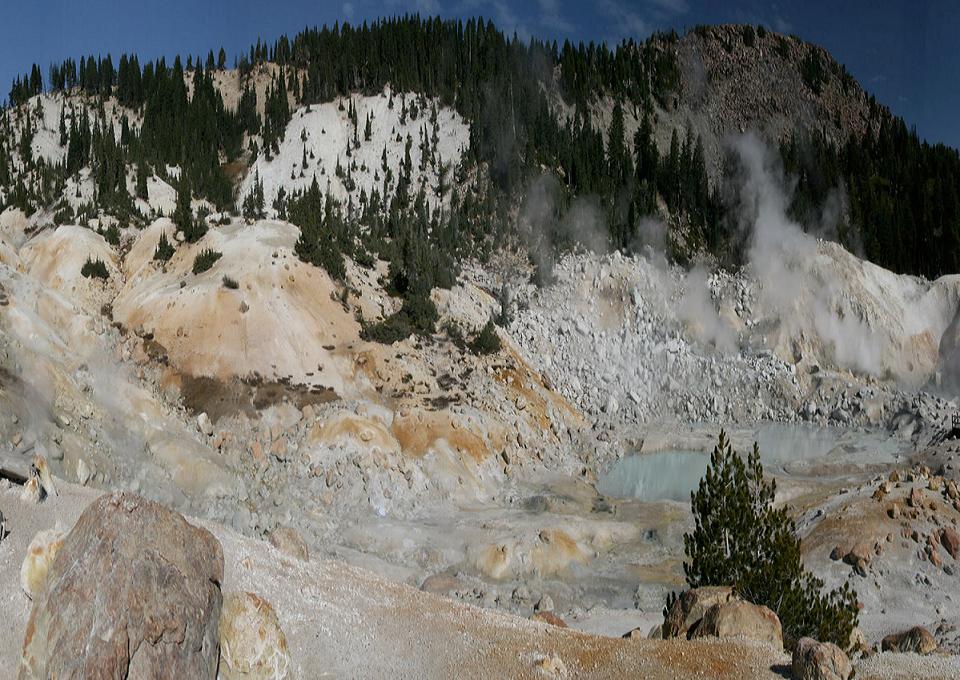
Lassen Volcanic Center, стратовулкан, 3187 (м). Последнее извержение 1917 год.Lassen Volcanic Center. Within the last 825KA, hundreds of explosive eruptions came from vents scattered over 500 km2. Surrounding Lassen Volcanic Center, over fifty effusive (non-explosive) eruptions have occurred in the last 100KY. The area has been relatively quiet for the last 25KY with three notable exceptions—the Chaos Crags eruption (1,100 years ago), the eruption of Cinder Cone (1666 A.D.), and the Lassen Peak eruption (A.D. 1914 to 1917). Lassen Volcanic Center hosts a vigorous geothermal system, numerous hot springs, steam vents, and boiling mud pots. Volcanic earthquakes are common, although most are too small to be felt. Ground surveys show localized subsidence of the volcano, probably due to motion on regional faults.Location: California, Shasta County. Composition: andesite, dacite - http://volcanoes.usgs.gov/volcanoes/lassen_volcanic_center/ |
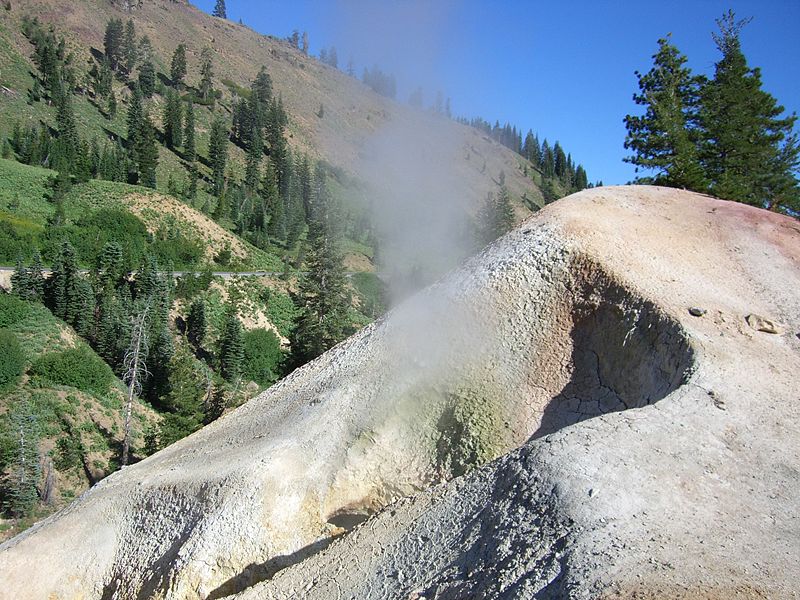
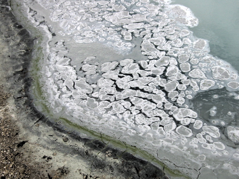
Lassen fumarols. Bumpass Hell contains boiling springs, mudpots, and fumaroles |
Thermal vents at Sulfur Works Lassen |
Hot spring in Lassen Volcanic National Park -http://en.wikipedia.org/wiki/Lassen_Volcanic_National_Park |
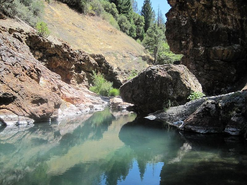
Crabtree Hot Springs, California on Rice Fork Eel River - http://en.wikipedia.org/wiki/Rice_Fork_Eel_River |
|
Карта вулкана Игл-Лейк-Филд- http://vulcanism.ru/120309.html |
Eagle Lake with Mtn. Lassen in the background. The Eagle Lake volcanic field occupies the junction of the Cascades, Sierra Nevada, and Basin and Range geologic provinces and consists of 15 cinder cones and basaltic lava flow vents within a larger Quaternary basaltic field. The vents are aligned along faults defining the Eagle Lake volcano-tectonic depression, and are the southernmost example of late Quaternary back-arc spreading in the northwestern Great Basin. The latest long-lived eruptive period has been roughly estimated to have occurred about 50-100KA before present (Grose, in Wood and Kienle 1990). Miller (1989) mapped four Holocene centers in the Eagle Lake volcanic field.Location: California, Lassen County. Volcano type: cinder cones and lava flows. Composition: basalt |
Eagle Lake Field, жерловая трещина, 1652 (м) Eagle Lake is 1700 m above sea level in north eastern California north of Susanville in Lassen County. It is the second largest natural freshwater lake wholly in California. The Lake and its immediate drainage are located in a high semi-arid plateau characterized by basaltic lava flows, volcanoes, and cinder cones. Some of the lava flows are fairly recent, having occurred not more than a few centuries ago. The higher western portion of the drainage basin consists mainly of volcanic mountains that form the east flank of the Cascade Range. |
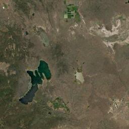
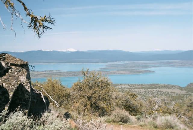
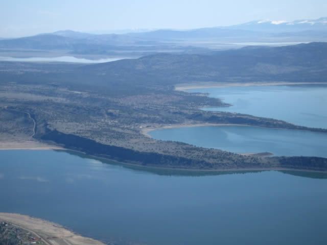
Clear Lake, вулканическое поле, 1439 (м) http://vulcanism.ru/120310.html, http://vulcan.wr.usgs.gov/Volcanoes/California/ClearLake/framework.html, http://vulcan.wr.usgs.gov/Volcanoes/California/ClearLake/description_clear_lake.html |
Clear lake. Latest activity -10KA - http://nationalatlas.gov/dynamic/dyn_vol-ca.html |
The Clear Lake Volcanic Field is a volcanic field beside Clear Lake in northern Coast Ranges. The site of late-Pliocene to early Holocene activity, the volcanic field consists of lava domes, cinder cones, and maars with eruptive products varying from basalt to rhyolite.[ Cobb Mountain and Mount Konocti are the two highest peaks in the volcanic field, at 1,440 m and 1,306 m respectively. The field''s magma chamber also powers a geothermal field The Geysers, which hosts the largest complex of geothermal power plants in the world. These can generate approximately 2000 megawatts, enough to power two cities the size of San Francisco .The Clear Lake volcanic field ( late Pliocene to Holocene) lies in a tectonically active, complex geologic setting within the San Andreas transform fault system in northern Coast Ranges of California. Clear Lake and the volcanic field are located within a fault-bounded, locally extensional basin. The lake is probably volcano-tectonic in origin, but is not a caldera lake. The volcanic field is the northernmost of a series of young Cenozoic volcanic fields in the Coast Ranges. Within the field, eruptive loci have migrated northward through the last 2.1 million years. Eruptive centers are lacking. Volcanism appears to be related to extension in a pull-apart basin within the San Andreas fault system and is not directly related to subduction, which ceased off the California coast at this latitude around 3 MA. The Clear Lake volcanics range from basalt through rhyolite in composition. Basalt is rare, and the dominant composition is dacite. Four eruptive episodes separated by time gaps of 0.15 - 0.2 MY were characterized by different compositional ranges. Total erupted volume probably exceeds 70 cubic kilometers. Volcanism has been largely non-explosive with only one major silicic air-fall tuff and no ash-flow tuffs. Numerous young locally vented deposits of palagonitic mafic tuff occur around the southeast shore of Clear Lake - http://www.rumormillnews.com/cgi-bin/archive.cgi?noframes;read=198086 |
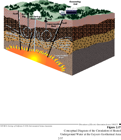
The Geysers Geothermal Field, Sulphur Bank Mine - McLaughlin Mine Gravity and teleseismic studies suggest that a large silicic magma chamber around 14 kilometers in diameters, lies 7 kilometers and deeper beneath the volcanic field. This reservoir is thought to be the heat source for The Geysers geothermal field (on the southwest side of the volcanic field), which is the largest producing geothermal field in the world, with installed electrical generating capacity of around 2,000 megawatts in 1988, enough electricity for about two cities the size of San Francisco. Numerous thermal springs occur along northwest to north-northwest-trending faults that are subparallel to the main San Andreas fault. Associated epithermal deposits of mercury and gold include the Sulphur Bank Mine (still the site of active mercury deposition) and the McLaughlin Mine (a major disseminated gold deposit in an outlier of the Clear Lake volcanics), and associated hot springs deposits - http://www.cpuc.ca.gov/Environment/info/esa/divest-pge-two/eir/chapters/02-projd.htm, http://vulcan.wr.usgs.gov/Volcanoes/California/ClearLake/description_clear_lake.html, http://www.rumormillnews.com/cgi-bin/archive.cgi?noframes;read=198086, |
Clear Lake Volcanic Field is located about 90 miles north of San Francisco, California. The Geysers steam field, which sits at the southwest margin of the volcanic region, is host to one of the world’s most productive geothermal fields. The heat driving the geothermal system emanates from a zone of partially molten magma deep below Clear Lake volcanic field. The volcanic features are Quaternary and include rhyolitic lava dome complexes, cinder cones, and maars of basaltic composition. The most prominent volcanic feature is 300 KA-old Mount Konocti, rising about 975 m above the southwestern shore of the lake. The most recent eruptions occurred about 11 KA around Mount Konocti. Although Clear Lake volcanic field has not erupted for several millennia, sporadic volcanic-type earthquakes do occur, and the numerous hot springs and volcanic gas seeps at in the area point to its potential to erupt again. Location: California, Lake County. Elevation: 1,439 (m) Volcano type: volcanic field Composition: basalt to rhyolite - http://volcanoes.usgs.gov/volcanoes/clear_lake/ |
Mount Konocti .The westernmost site of Quaternary volcanism in California, the Clear Lake field is located far to the west of the Cascade Range in a complex geologic setting within the San Andreas transform fault system. Mount Konocti, a composite dacitic lava dome on the south shore of Clear Lake, is the largest volcanic feature. Volcanism has been largely non-explosive, with only one major airfall tuff and no ash flows. The latest eruptive activity, forming maars and cinder cones along the shores of Clear Lake, continued until about 10KA. A large silicic magma chamber provides the heat source for the Geysers, the world''s largest producing geothermal field- http://www.rumormillnews.com/cgi-bin/archive.cgi?noframes;read=198086, http://vulcan.wr.usgs.gov/Volcanoes/California/ClearLake/description_clear_lake.html, http://en.wikipedia.org/wiki/Clear_Lake_Volcanic_Field |
The late-Pliocene to early Holocene Clear Lake volcanic field in the northern Coast Ranges, contains lava dome complexes, cinder cones, and maars of basaltic-to-rhyolitic composition. The westernmost site of Quaternary volcanism in California, the Clear Lake field is located far to the west of the Cascade Range in a complex geologic setting within the San Andreas transform fault system. Mount Konocti, a composite dacitic lava dome on the south shore of Clear Lake, is the largest volcanic feature. Volcanism has been largely non-explosive, with only one major airfall tuff and no ash flows. The latest eruptive activity, forming maars and cinder cones along the shores of Clear Lake, continued until about 10KA. A large silicic magma chamber provides the heat source for the Geysers, the world''s largest producing geothermal field. Some researchers (e.g. Christiansen and Lipman, 1972) have suggested that Sutter Buttes and the Sonoma and Clear Lake volcanics, south and southwest of Lassen, are older extensions of subduction-related Cascade volcanism. This seems unlikely. If Sutter Buttes were part of a series of older Cascade stratovolcanoes abandoned due to the northward migration of the south end of Juan de Fuca Plate, the "last Cascade volcano" hypothesis would be tenable. But northward, arc volcanoes are young and active. In fact, why do the Cascades have an abrupt southern termination? The Clear Lake and Sonoma volcanics are the less-than-5-million-year old components of a northwesterly younging line of volcanic fields of Tertiary to Holocene age (Hearn, et.al., 1981). All these volcanics lie within the San Andreas fault system, which appears to have provided magma access to the surface. Hearn et.al. point out that the timing of the volcanism suggests that it follows termination of subduction, as the Mendocino triple junction migrated northward. They also propose that the volcano alignment reflects an underlying hot spot. That suggestion seems inconsistent with the northward movement of the Pacific Plate which most of the volcanics ride. These volcanics are among the closest to a subduction plate boundary of any in the world and will repay closer tectonic investigation. Similarly, a tiny sliver of basalt dated at 3.57 million years (Prowell, 1974, quoted in Luedke and Smith, 1981) occurs 45 kilometers east of Santa Cruz, Calfiornia near the Calaveras and Hayward faults. Apparently leakage of basalts along the San Andreas fault system has occurred repeatedly- http://vulcan.wr.usgs.gov/Volcanoes/California/ClearLake/description_clear_lake.html. |
The Clear Lake volcanic field) lies in a tectonically active, complex geologic setting within the San Andreas transform fault system in northern Coast Ranges of California. Clear Lake and the volcanic field are located within a fault-bounded, locally extensional basin. The lake is probably volcano-tectonic in origin, but is not a caldera lake. The volcanic field is the northernmost of a series of young Cenozoic volcanic fields in the Coast Ranges. Within the field, eruptive loci have migrated northward through the last 2.1 MY. Eruptive centers are lacking. Volcanism appears to be related to extension in a pull-apart basin within the San Andreas fault system and is not directly related to subduction, which ceased off the California coast at this latitude around 3 million years ago. The Clear Lake volcanics range from basalt through rhyolite in composition. Basalt is rare, and the dominant composition is dacite. Four eruptive episodes separated by time gaps of 0.15 - 0.2 MY were characterized by different compositional ranges. Total erupted volume probably exceeds 70 cubic kilometers. Volcanism has been largely non-explosive with only one major silicic air-fall tuff and no ash-flow tuffs. Numerous young locally vented deposits of palagonitic mafic tuff occur around the southeast shore of Clear Lake- http://vulcan.wr.usgs.gov/Volcanoes/California/ClearLake/description_clear_lake.html |
Golden Trout Creek, вулканическое поле, 2886 (м). Последнее извержение 5550 год до н.э. One mafic cinder cone and lava flow about 10 – 5 KA. Formation of cinder cones, small volumes of tephra and lava flows. Kern Plateau: This subsection is a high plateau west of the main crest of the Sierra Nevada. It is between the Kern Canyon Fault and the eastern slope of the Sierra Nevada from near Golden Trout Creek south to South Fork Valley. The higher part of the Scodie Mountains is included in this subsection. It has a temperate to cold and semi-arid to subhumid climate. Mesozoic granitic rocks predominate in this subsection. Also, pre-batholith metamorphic rocks are moderately extensive. Monache and Templeton Mountains are small Tertiary andesitic cones. There are small Pleistocene basalt flows along Golden Trout Creek and the South Fork of the Kern River and two cinder cones associated with them. Quaternary alluvium is common in small areas along streams, but Pleistocene glacial till is sparse. This subsection is characterized by gentle to moderately steep slopes on a rolling plateau and steep to very steep slopes in the canyon of the Kern River and on edges of the plateau. The Kern River runs from north to south in nearly a straight line along the Kern Canyon Fault. The plateau is not deeply incised, except near the edge of it and along the Kern River. The subsection elevation ranges from about 1,0 or 1,2 km up to 3,8 km. Fluvial erosion and deposition are the main geomorphic processes. Groundhog cinder cone, the youngest of the Golden Trout Creek volcanic field, is breached to the NE. Groundhog cone was the source of a Holocene lava flow that traveled 6 km to the west down Golden Trout Creek The volcanic field consists of a group of Quaternary alkali olivine basaltic cinder cones and lava flows in the Sierra Nevada about 25 km south of Mount Whitney. Lava flows erupted through light-colored Mesozoic granitic rocks of the Sierra Nevada batholith visible behind Groundhog cone and on its upper right side- http://www.volcano.si.edu/world/volcano.cfm?vnum=1203-17-&volpage=photos&photo=102044, http://vulcan.wr.usgs.gov/Volcanoes/California/GoldenTroutCreek/framework.html, http://www.volcano.si.edu/world/volcano.cfm?vnum=1203-17-&volpage=photos. Summary of Holocene eruptive activity http://vulcan.wr.usgs.gov/Volcanoes/California/Hazards/Bulletin1847/table_holocene_volcanoes.html |
South Fork cinder cone (center) is seen from the NW with Ramshaw Meadow (upper left) behind it. Templeton Mountain is the rounded peak beyond South Fork cone, and Olancha Peak on the crest of the Sierra Nevada is on the center horizon. South Fork (Red Hill) cone was formed about 176,000 years ago and produced a lava flow 10 km to the west that may have reached as far as the Kern River. The cinder cone was erupted through a bedrock ridge of the Sierra Nevada, and inclusions of quartz monzonite are common near the vents |

http://westernviews.us/2008/06/ -nature
http://volcanoes.usgs.gov/observatories/calvo/
http://vulcanism.ru/countries.html
http://thewatchers.adorraeli.com/2012/02/12/new-volcano-observatory-in-california-to-monitor-dozens-of-potentially-threating-volcanoes/
http://www.volcano.si.edu/world/region.cfm?rnum=1203 - California volcanoes
Summary of Holocene eruptive activity - http://vulcan.wr.usgs.gov/Volcanoes/California/Hazards/Bulletin1847/table_holocene_volcanoes.html
Cascade Volcanoes of California
California''s Geomorphic Provinces
next
California Volcano Observatory (CalVO)
Glossary