 | Arizona. Volcanoes |
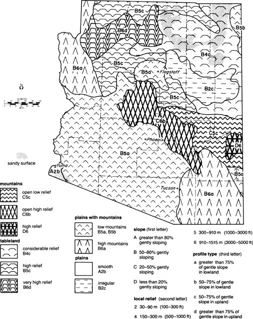
Generalized Topography of Arizona (after M. E. Hecht and R. W. Reeves, 1981) -http://southwest.library.arizona.edu/azso/body.1_div.2.html !!!! |
|
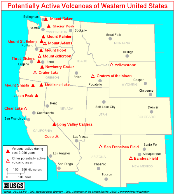
The volcanic history of Arizona spans more than one billion years. There are seven volcanic fields which have erupted within the last four million years. One of them entombs pottery of local inhabitants of the time. One dammed the Colorado River in the Grand Canyon several times. Another produces world-class gemstones, and another is associated with the 1887 earthquake which shook Southern Arizona and Northern Sonora.The map below, from the Arizona Geological Survey shows the location of these recent and older volcanic fields. oung Volcanic Fields shown in red - http://tucsoncitizen.com/wryheat/tag/pinacate/. The map of http://www.azgs.az.gov/ |
|
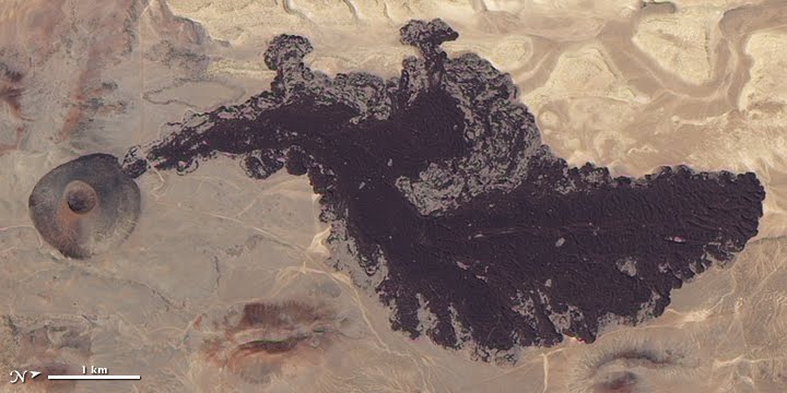
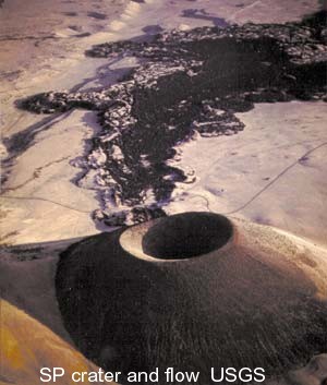
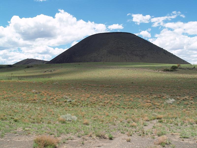
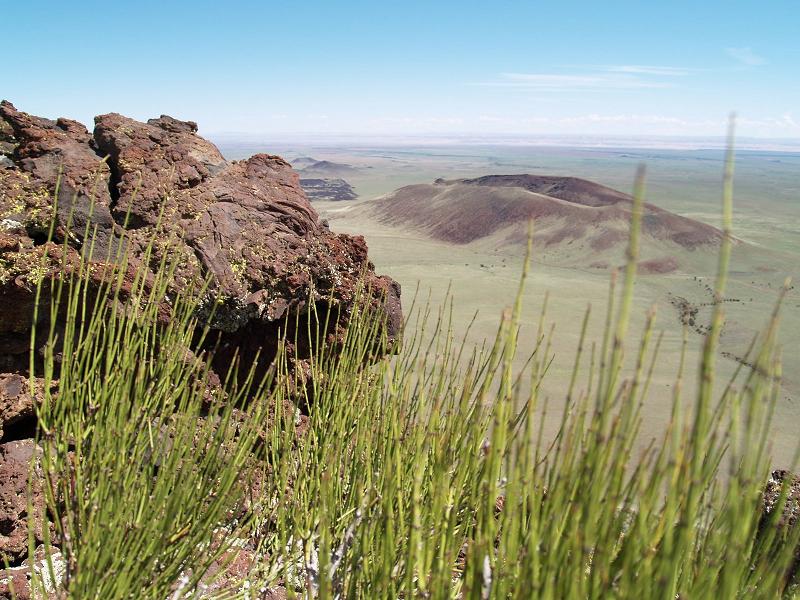
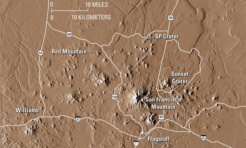
San Francisco lava flow. Most of the more than 600 volcanoes in the San Francisco Volcanic Field are basalt cinder cones. Basalt has the lowest viscosity of all common magmas. Cinder cones are relatively small, usually less than 1,000 feet tall, and form within months to years. They are built when gas-charged frothy blobs of basalt magma are erupted as an upward spray, or lava fountain. During flight, these lava blobs cool and fall back to the ground as dark volcanic rock containing cavities created by trapped gas bubbles. If small, these fragments of rock are called “cinders” and, if larger, “bombs.” As the fragments accumulate, they build a cone-shaped hill. Once sufficient gas pressure has been released from the supply of magma, lava oozes quietly out to form a lava flow. This lava typically squeezes out from the base of the cone and tends to flow away for a substantial distance because of its low viscosity. SP Crater, 25 miles north of Flagstaff, is an excellent example of a cinder cone and its associated lava flow.The volcanic field also contains lava domes. These are dome-shaped, steep-sided piles of viscous dacite and rhyolite lava. These can expand like balloons when lava wells up inside the dome, or the dome can break and develop by buildup of successive layers.A side story, the cinder cone gold scam: Among my duties as an exploration geologist was examining properties submitted to our company by third parties. One submitted property was a gold prospect in one of the basaltic cinder cones. It is extremely unlikely that gold occurs in cinder cones. |
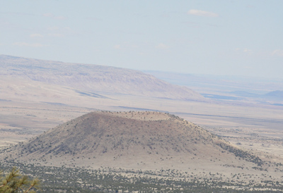
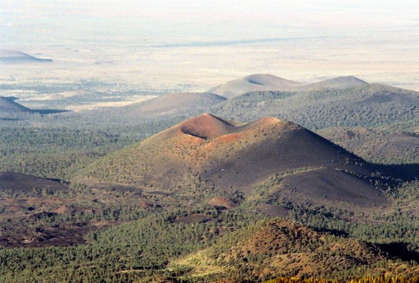
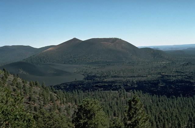
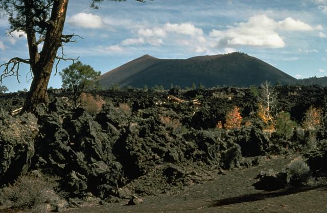
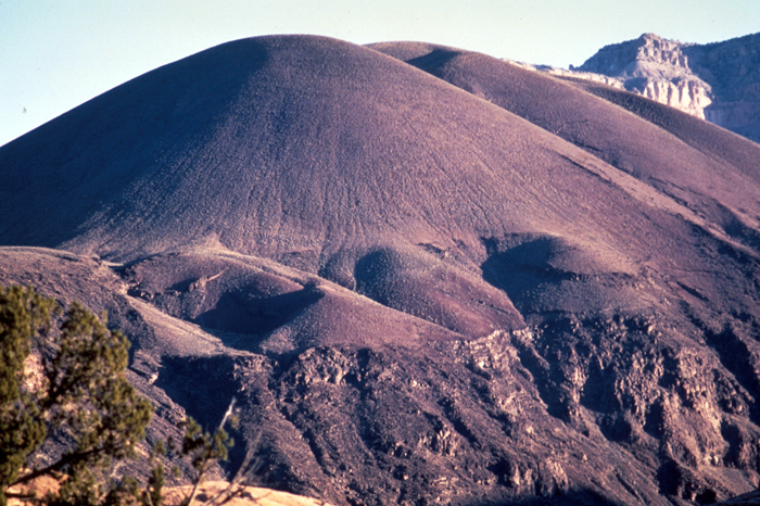
SP Crater. The younger volcanic cones and their flows are basaltic, such as SP crater (71,000 years old) and Sunset Crater in San Francisco lawa flow |
SP cinder cone. More - http://arizonahiking.blogspot.com/2008_09_21_archive.html |
|
|
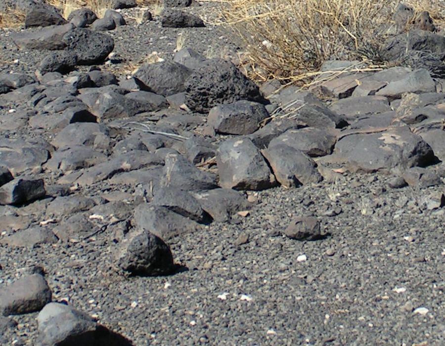
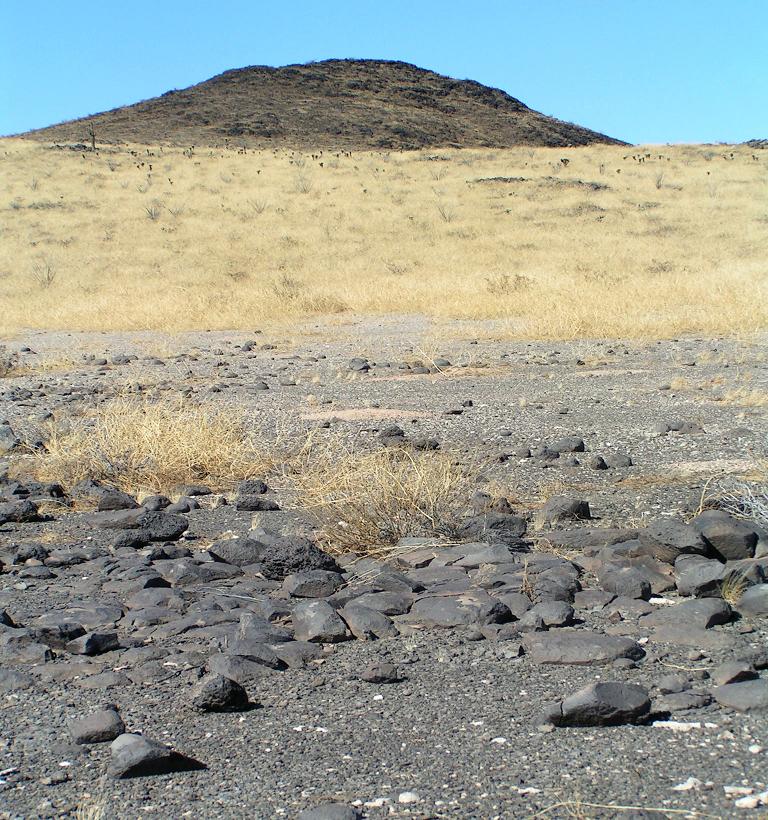
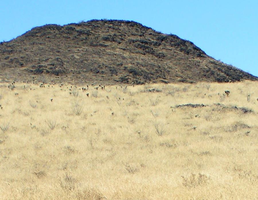
Antelope Hill |
Red Mountain Volcano—A Spectacular and Unusual Cinder Cone in Northern Arizona, http://pubs.usgs.gov/fs/2002/fs024-02/ |
|
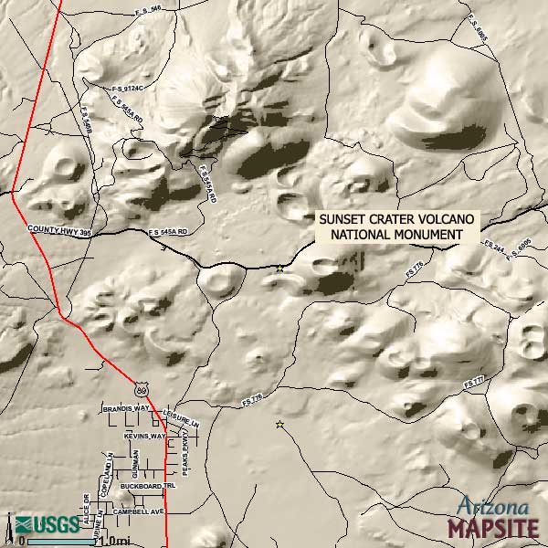
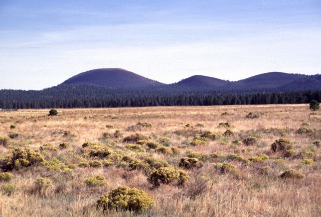
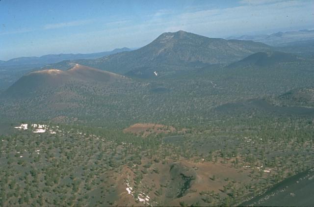
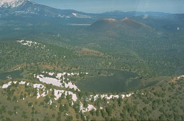
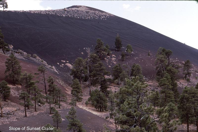
Sunset Crater (left) and adjacent cinder cones are seen here from the west across the meadows of Bonito Park. Sunset Crater and adjacent cones were erupted along a 10-km-long, NW-SE-trending line, with Sunset Crater being the NW-most vent. The Sunset Crater eruptions severly affected Sinagua Indians living in the area, who temporarily evacuated the region -http://www.volcano.si.edu/world/volcano.cfm?vnum=1209-02-&volpage=photos |
Сансет Кратер в Аризоне пример шлаковых конусов Sunset Crater,last eruption 1050-1100 years named for its brilliantly colored scoria deposits mantling the cone, is the youngest of the more than 550 vents of the vast San Francisco volcanic field in northern Arizona. The eruptions forming the 340-m-high Sunset Crater cinder cone were initially considered from tree-ring dating to have begun between the growing seasons of 1064-1065 AD; however, more recent paleomagnetic evidence places the onset of the eruption sometime between about 1080 and 1150 AD. The largest vent of the eruption, Sunset Crater itself, was the source of the Bonito and Kana-a lava flows that extended about 2.5 km NW and 9.6 km NE, respectively. Additional vents along a 10-km-long fissure extending SE produced small spatter ramparts and a 6.4-km-long lava flow to the east. The Sunset Crater eruption produced a blanket of ash and lapilli covering an area of more than 2100 sq km and forced the abandonment of settlements of the indigenous Sinagua Indians. Sunset Crater is the youngest volcanic feature of the San Francisco Mountain volcanic field, which covers a vast area of northern Arizona between Flagstaff and the Grand Canyon. The Sunset Crater eruption began about 1100 AD from a chain of cinder cones and vents trending NW-SE, the largest of which is Sunset Crater. Three lava flows were erupted, the longest of which traveled 11 km to the NE - http://www.volcano.si.edu/world/volcano.cfm?vnum=1209-02- http://www.arizonatribe.com/arizona_scenery.htm, photos -http://www.volcano.si.edu/world/volcano.cfm?vnum=1209-02-&volpage=photos |
The 60-m-deep Gyp Crater in the foreground is located at about the midpoint of a 10-km-long eruptive fissure extending SE from Sunset Crater, the unvegetated cinder cone at the left-center. Paleomagnetic evidence places the age of the Sunset Crater eruption at between about 1080 and 1150 AD. O''Leary Peak, a Pleistocene lava dome, forms the prominent peak in the right background-http://www.volcano.si.edu/world/volcano.cfm?vnum=1209-02-&volpage=photos |
Sunset Crater at the upper right is seen in this aerial view along a 10-km-long eruptive fissure extending to its SE. An eruption from Gyp Crater, immediately behind the left rim of the snow-dappled Pleistocene Double Crater in the foreground, occurred along the SE-trending fissure. Snow-capped San Francisco Mountain appears in the background at the upper left-http://www.volcano.si.edu/world/volcano.cfm?vnum=1209-02-&volpage=photos |
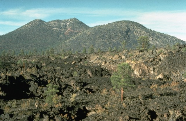
The rugged Bonito lava flow in the foreground was erupted from Sunset Crater in two stages. The flow originated from vents at the west to NW base of Sunset Crater, which is out of view to the right. The peak beyond the flow to the north is O''Leary Peak, which consists of two rhyodacitic lava domes of Pleistocene age. O''Leary Peak is the NE-most silicic center in the San Francisco Mountain volcanic field - http://www.volcano.si.edu/world/volcano.cfm?vnum=1209-02-&volpage=photos |
The Bonita lava flow in the foreground of this view from O''Leary Peak, NW of Sunset Crater, was erupted from two or more vents on the western to NW flank of Sunset Crater. The flow contains both scoria-mantled portions erupted concurrently with major explosive activity from Sunset Crater and darker, scoria-free portions erupted during later stages of the eruption. Portions of the scoria-mantled flow were broken away and rafted along during the late-stage lava extrusion - http://www.volcano.si.edu/world/volcano.cfm?vnum=1209-02-&volpage=photos |
The Sunset Crater eruption is considered from paleomagnetic evidence to have begun about 1080-1150 AD. The Bonito lava flow in the foreground originated from Sunset Crater, the cinder cone in the background. The Sunset Crater eruption produced a blanket of ash and lapilli covering an area of more than 2100 sq km and forced the abandonment of settlements of the indigenous Sinagua Indians-http://www.volcano.si.edu/world/volcano.cfm?vnum=1209-02-&volpage=photos |
Sunset Crater, seen here from the NE, is the centerpiece of Sunset Crater National Monument. During the 1920''s, geologist H.S. Colton successfully lobbied to prevent a Hollywood movie company from blowing up the cone to simulate a volcanic eruption. The monument was subsequently established to protect the cone. The proximal part of the Kana-a lava flow, erupted from a vent on the NE flank, is buried here by tephra. The flow was the longest from the Sunset Crater vent system and traveled 11 km to the NE. |
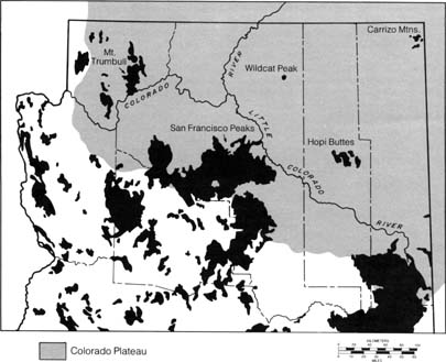
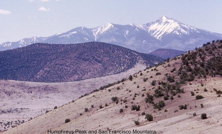
San Francisco Volcanic Field (FL near Flagstaff) The San Francisco volcanic field near Flagstaff has been active for about 6 MA. Sunset Crater, a cinder cone east of Flagstaff, is less than 1MY.The San Francisco mountains, which include Humphreys Peak, Arizona’s highest mountain, is a stratovolcano which erupted between 1 million and 400,000 years ago. This volcanic mountain consists of interspersed layers of andesitic lava, cinders, ash, and volcanic mudflows. |
Springerville Volcanic Field (SP)-Most of the basaltic flows in the Springerville volcanic field are between 2.1 million and 300,000 years old. Some older flows, 6- to 8 million year old flows occur to the south. There are no stratovolcanoes here, only about 400 cinder cones and their associated flows -http://tucsoncitizen.com/wryheat/tag/pinacate/ |
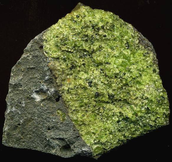
Lherzolite mantle xenolith (greenish) in vesicular basanite (gray) (7.5 cm across) from the Peridot Mesa Flow (Middle Pleistocene, 580 k.y.) at Peridot Mesa, Arizona- http://www.newark.osu.edu/facultystaff/personal/jstjohn/Documents/Volcanic-Rocks/Peridot-Mesa.htm The Peridot Mesa lavas have common greenish-colored masses of lherzolite. Lherzolite is a variety of peridotite (other varieties of peridotite include dunite, pyroxenite, wehrlite, and harzburgite). Lherzolites are coarsely-crystalline, ultramafic intrusive igneous rocks having mixtures of olivine and pyroxene (more then 10% each). The lherzolite mass shown below is dominated by forsterite olivine (green). The black specks are pyroxene crystals. There''s also some chromian diopside pyroxene, which has a darker green color than the olivine. The lherzolite masses in the Peridot Mesa lavas are samples of mantle rock.Some of the green olivine crystals are large enough, transparent enough, and richly green enough to be gem quality. Locality: Peridot Mesa, San Carlos Volcanic Field, San Carlos Apache Reservation, southeastern margin of Gila County, southeastern Arizona, USA.The volcanic rocks making up Peridot Mesa are gray vesicular basanites (= feldspathoid olivine basalts) of the Peridot Mesa Flow, a 3 to 35 meter thick lava flow erupted during the Middle Pleistocene (580KA). |
San Carlos Volcanic Field (SC) The San Carlos volcanic field is the basalt and peridotite lavas erupt between 7 million and 500,000 years ago. Peridotite, from whence the term peridot comes, is a coarse igneous rock consisting mainly of the minerals pyroxene and olivine. Peridot is gem-quality olivine, a magnesium-iron silicate. It is claimed that 90% of the world’s peridot comes from Peridot Mesa in this volcanic field. Peridot Mesa is a diatreme (a breccia-filled vent formed by gaseous explosion) and was followed by lava flows - http://www.mountain-forecast.com/peaks/San-Carlos-volcanic-field-http://tucsoncitizen.com/wryheat/tag/pinacate/ |
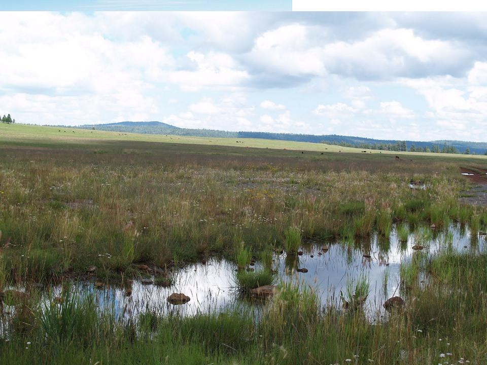
The San Bernardino Valley, Cochise County, Arizona. San Bernardino Volcanic Field (SB) The San Bernardino volcanic field in the southeast corner of Arizona contains about 130 vents and cinder cones, maars, and flows of olivine basalt. These were erupted between 1 million and 27,000 years ago. An earthquake in 1887 was centered just south of the border in the San Bernardino Valley.Maars are craters created by a steam blast. Paramore Crater is the largest of these, about 1 km by 1.5km and about 60 m deep.In the northern extension of the San Bernardino Valley, the San Simon Valley, there are still many hot springs. Paleozoic and Mesozoic sedi-mentary rocks and mid-Tertiary volcanic most likely form the bedrock floor of the basin. The field covers some 850 km and consists of olivine basalt flows, tuff rings and maars with 130 identified volcanic vent areas and cinder cones. Maars are craters created by a steam blast. Paramore crater is the largest of these, about 1 km by 1.5km and about 60 m deep. volcanoes: The land was full of volcanic bombs and years of lava flows. This adventure had brought new meaning of Volcanoes in Arizona’s own backyard. Limited radiometric dating indicates the exposed rocks of the San Bernardino volcanic field had erupted between 750,000 and 260,000 years ago. The mountains surrounding the valley are composed of igneous, metamorphic, and sedimentary rocks (Cooper, 1959) . The sights most commonly seen are those of Cinder cones, with varying amounts of bombs, vent lava, and agglutinate breccia Bombs in cinder cones often have lherzolite fragments in the centers and megacryst spinel, potash-oligoclase, kaersutite, clinopyroxene, and olivine occur in the talus of cinder cones and in the lavas. The molted rock had become cooled and created its own layers replicating slate or shale. Lava flows, ranging in age from 260 ka to 750 ka, are typically thin, cover a fairly limited area, and form a series of overlapping surfaces - http://skywalker.cochise.edu/wellerr/geology-SEAZ/san-bernardino/San-Bernardino-list.htm - http://tucsoncitizen.com/wryheat/tag/pinacate/, http://skywalker.cochise.edu/wellerr/students/san-bernardino/project.htm |
|
Sentinel Volcanic Field |
|
Sentinel Volcanic Field (SE)The Sentinel volcanic field, west of Gila Bend, AZ, contains basalt flows 2- to 6 million years old. This field may be related to the larger Pinacate field to the south - http://tucsoncitizen.com/wryheat/tag/pinacate/ |
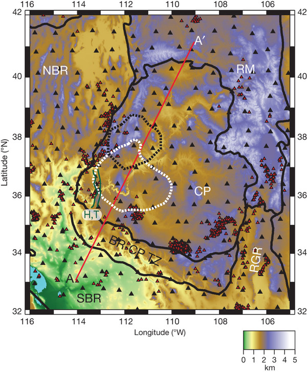
The map shows topography, in km, of the Colorado plateau and surrounding tectonic/physiographic provinces, province boundaries (black lines), and the locations of approximately 220 seismograph stations. CP, Colorado plateau; NBR, northern Basin and Ridge |
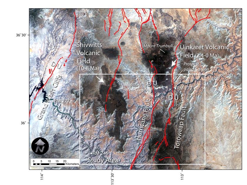
Major Quaternary faults, including the Toroweap and Hurricane |
Uinkaret volcanic field is bounded by the Toroweap and Hurricane faults |
Hurricane and Toroweap faults do not displace Hell''s Hollow |
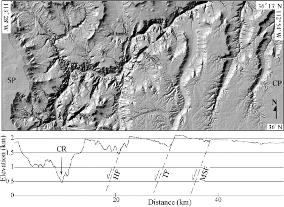
Plan view (top) and elevation profile (bottom) along 36°N, which forms southern boundary of the plan view of Hurricane and Toroweap faults in western Grand Canyon region, Arizona, from U.S. Geological Survey 10 m resolution digital elevation model. From west to east, the elevation profile begins on Shivwits Plateau (SP); crosses Colorado River (CR), Hurricane fault (HF), Toroweap fault (TF), and Mohawk Stairway fault (MSF); and ends on Coconino Plateau (CP)-http://geology.gsapubs.org/content/31/1/e16/F1.expansion.html.view of Hurricane and Toroweap faults in western Grand Canyon |
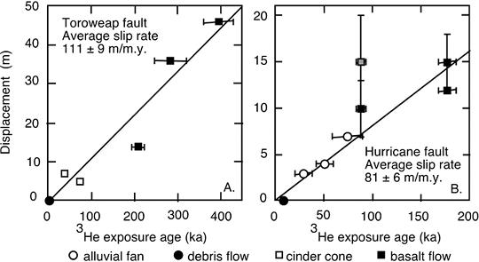
Vertical displacement rates of (A) Toroweap and (B) Hurricane faults |
View south towards Diamond Peak and the Hurricane Fault-http://earthly-musings.blogspot.com/2009_09_01_archive.html |
Toroweap |
Toroweap |
Toroweap Point in Grand Canyon national park |
Toroweap |
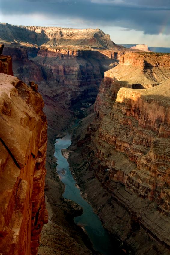
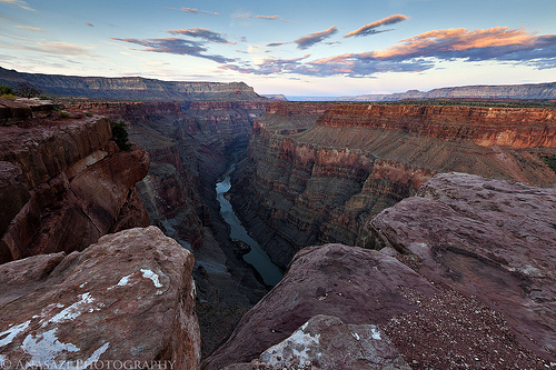
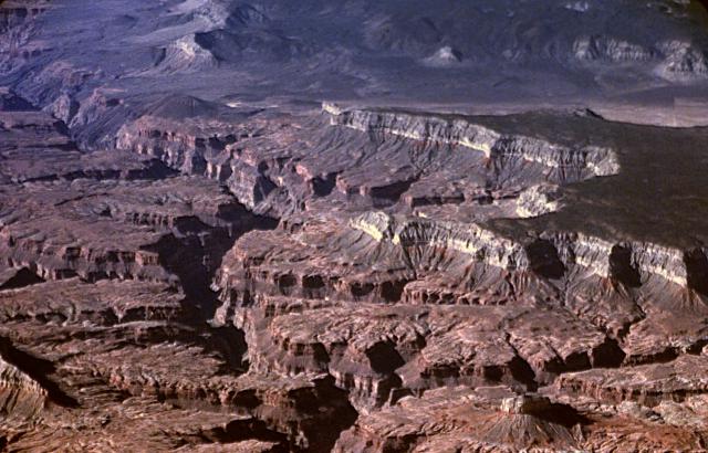
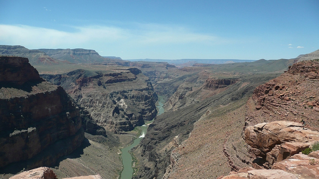
Basalts from the Uinkaret volcanic field flow into the Grand Canyon from its North Rim. On the right is Lava Falls, with Vulcan''s Throne at the top, just above the brightly-lit cliff face at top center. Vulcan''s Throne is about 73KA. These are among the most recent features of the Grand Canyon. The topmost layers over which the lava flowed, the Kaibab Limestone, was deposited in early Permian time, around 290 MA-http://www.volcano.si.edu/world/region.cfm?rnum=1209 |
Uinkaret field, Mohave County, Arizona, Volcanic field, 1555 m, last eruption 1025-1175 years. The small dark-colored pyroclastic cone on the right side of the Grand Canyon at the upper left is Vulcan''s Throne, part of the Uinkaret volcanic field, which lies on the north rim of the canyon. Lava flows that originated from the cone can be seen cascading into the Grand Canyon. These flows formed temporary lava dams in the canyon up to 200 m high. Light-colored rocks of the Kaibab Limestone form the steep cliffs bounding the mesa at the right.The Uinkaret volcanic field straddling the Grand Canyon contains cinder cones that have produced lava flows that repeatedly cascaded into the Grand Canyon, forming temporary lava dams up to 200 m high. Two of the most prominent landmarks are Vulcan''s Throne, a cinder cone on the north rim, and Vulcan''s Forge, a small volcanic neck erupted within the Colorado River, 1000 m below. Most of the Uinkaret field lies north of the Grand Canyon on the Uinkaret Plateau between the Toroweap and Hurricane faults. The Uinkaret volcanic field is largely Pleistocene in age, and Vulcan''s Throne has a cosmogenic helium age of about 73 KY. Volcanic activity has continued into the Holocene. One lava flow, from Little Springs, south of Pliocene Mount Trumbull, has a cosmogenic helium age of 1300 +/- 500 years BP. Pottery sherds dated at between 1050 and 1200 AD were found within the Little Springs lava flow, which occurred about the same time as the Sunset Crater eruption in the San Francisco volcanic field to the SE. Photo by Lee Siebert, 2000 (Smithsonian Institution)- http://www.volcano.si.edu/world/volcano.cfm?vnum=1209-01-&volpage=photo |
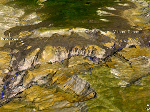
The Uinkaret volcanic field is an area of monogenetic volcanoes in northwestern Arizona, United States, located on the north rim of the Grand Canyon. Lava flows from the Uinkaret volcanic field that have cascaded down into the Grand Canyon, damming the Colorado River, have been used to date the canyon''s carving. One of these cascades is today''s Lava Falls. Lava Falls Rapid, below Lava Falls on the Colorado River, is "at all water levels, the most severe rapid in Grand Canyon.The Colorado River was dammed by lava flows multiple times from 725,to 100 KA. While some believe that these lava dams were stable, lasting up to 20 KY and forming large reservoirs, others think they failed quickly and catastrophically as massive floods. Prospect Cone. Lava flows traveled downriver 121 km from river mile 178 to 254.One lava flow, from Little Springs, south of Pliocene Mount Trumbull, has a cosmogenic helium age of 1300 +/- 500 years BP. Pottery sherds dated to between A.D. 1050 and 1200 were found within the lava flow, produced around the same time as the Sunset Crater eruption in the San Francisco volcanic field on the South Rim - http://en.wikipedia.org/wiki/Uinkaret_volcanic_field.Uinkaret Volcanic Field (UI on the map) lies on the north rim of the Grand Canyon in northwestern Arizona. Four major eruptions of basalt from this field flowed into the Grand Canyon and dammed the Colorado River between 725 and 475 KA, between 400 and 275 KA, between 225 and 150 KA, and between150 and 75 KA (Argon-40 to Argon-39) . http://geosphere.gsapubs.org/content/4/1/183.abstract). Some of the eruptions flowed down the canyon as much as 100kms. Some of the dams reached more than 200m high. When the river eventually over-topped and broke the dams there were great floods. There is no consensus on how long the dams lasted. Some think they may have lasted up to 20,000 years and formed large reservoirs.According to the Smithsonian Institution, “One lava flow, from Little Springs, south of Pliocene Mount Trumbull, has a cosmogenic helium age of 1300 +/- 500 years BP. Pottery sherds dated at between 1050 and 1200 AD were found within the Little Springs lava flow, which occurred about the same time as the Sunset Crater eruption in the San Francisco volcanic field to the SE.”- http://tucsoncitizen.com/wryheat/tag/pinacate/ |
Lava flow into the Grand Canyon at Vulcan''s Forge, in Arizona |
Vulcan''s Throne (top right) ,73 KA and Lava Falls, 2008 aerial photo |
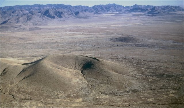
Vulcan''s Throne is a cinder cone volcano and a prominent landmark on the north rim of the Grand Canyon in Arizona, USA. Vulcan''s Throne, about a mile (1.7 km) west of Toroweap overlook, is part of the Uinkaret volcanic field |
Little Springs. AZ . Latest eruption 1050-1200 AD. Trail that is very close to Little Springs |
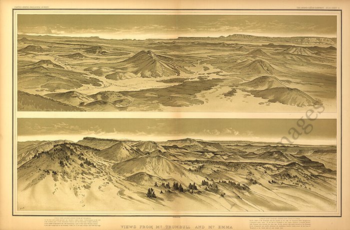
A view of Mt. Trumbull from a nearby cinder cone |
View from the top of Mt. Trumbull- http://en.wikipedia.org/wiki/Mount_Trumbull_Wilderness |
Mount Emma |
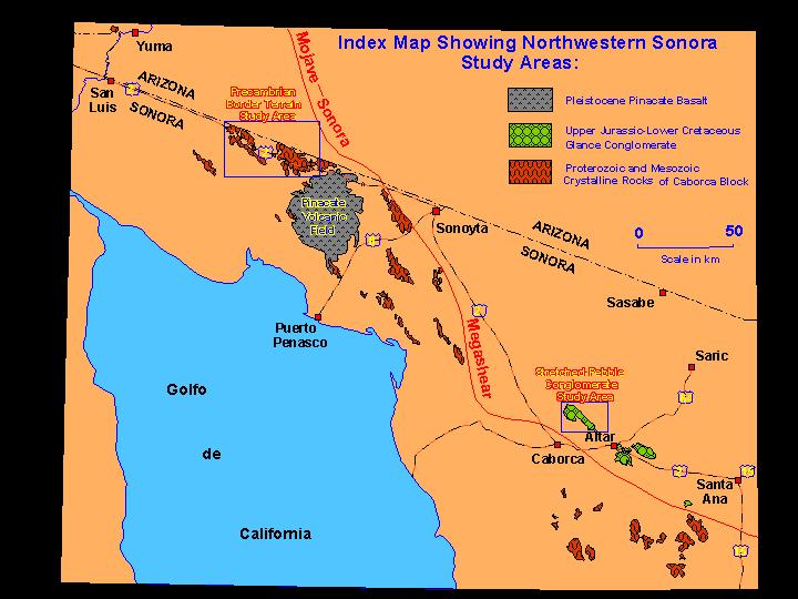
Pinacate Volcanic Field (PI) Most of the Pinacate volcanic field is in Sonora, just south of the Arizona border. Pinacate contains eleven giant-maar craters and hundreds of cinder cones. (See photos here and here.) The field has been active for 2 or 3 million years and eruptions have occurred as recently as 13,000 years ago. |
http://tucsoncitizen.com/wryheat/tag/magma/ |

http://arizonageology.blogspot.com/2011_02_01_archive.html arizona geo
http://en.wikipedia.org/wiki/List_of_volcanoes_in_the_United_States_of_America
http://scienceblogs.com/eruptions/2009/12/mvp_18_antelope_hill_az.php Az volcanoes
http://www.volcano.si.edu/world/region.cfm?rnum=1206
Sierra Grande in the distance, from the summit of Capulin Volcano
http://myvintagecameras.blogspot.com/2010/08/weekly-volcano-32-san-francisco-peaks.html
Capulin Volcano National Monument is to the north of where these
The Raton-Clayton Volcanic Field
Cabezon Peak is the largest volcanic neck in the Mt. Taylor volcanic field
Jeff Davis Peak, one of the highest peaks entirely within, Nevada
http://www.photovolcanica.com/VolcanoInfo/Wai-O-Tapu/Wai-O-Tapu.html -new zealand
http://www.photovolcanica.com/VolcanoInfo/Dallol/Dallol.html
http://geology.com/volcanoes/types-of-volcanic-eruptions/ Types of Volcanic Eruptions
http://geology.com/rocks/igneous-rocks.shtml - Igneous Rocks
http://geology.com/volcanoes/ volcanos and map collection
http://www.alaskadispatch.com/article/alaskas-biggest-volcanic-eruptions alasca
http://geology.com/news/category/volcanoes.shtml geo
http://geology.com/satellite/arizona-satellite-image.shtml arizona
. http://geology.com/news/category/volcanoes.shtml
http://geology.com/news/category/volcanoes.shtml alaska
http://geology.com/novarupta/ alaska
http://geology.com/news/category/volcanoes.shtml
http://geology.com/volcanoes/
http://geology.com/articles/active-volcanoes-solar-system.shtml solar system volcanoes
http://geology.com/states/california.shtml california
More than 500 volcanic vents have been identified in the State of California. At least 76 of these vents have erupted, some repeatedly, during the last 10 KA.
http://www.sciencedaily.com/releases/2007/11/071108141612.htm -global warmong volcano Science dayly
http://www.boston.com/bigpicture/2010/09/around_the_solar_system.html mars sheld
http://nationalatlas.gov/dynamic/dyn_vol-ca.html
http://nationalatlas.gov/dynamic/dyn_vol-ak.html alaska
http://nationalatlas.gov/dynamic/dyn_vol-us.html other
http://www.goldengatephoto.com/geotours/cgp1.html geomorphology
http://maydamedia.com/Chapters/Chapter19/CA2.html physical geography
http://maydamedia.com/Chapters/Chapter19/CA1.html cal geo angelin
Summary of Holocene eruptive activity http://vulcan.wr.usgs.gov/Volcanoes/California/Hazards/Bulletin1847/table_holocene_volcanoes.html
http://www.volcano.si.edu/world/region.cfm?rnum=12&rpage=highlights volcanoes
http://vulcan.wr.usgs.gov/Volcanoes/California/framework.html
http://www.nps.gov/labe/index.htm lava beds medicine lake, http://vulcan.wr.usgs.gov/Volcanoes/MedicineLake/Locale/framework.html
http://www.volcano.si.edu/world/region.cfm?rnum=1203 california volcanoes 1111111
http://www.volcano.si.edu/world/region.cfm?rnum=1203 all parts
map
Large red triangles show volcanoes with known or inferred Holocene eruptions; small red triangles mark volcanoes with possible, but uncertain Holocene eruptions or Pleistocene volcanoes with major thermal activity. Yellow triangles distinguish volcanoes of other regions- http://www.volcano.si.edu/world/region.cfm?rnum=12
http://www.volcano.si.edu/world/region.cfm?rnum=1204
http://volcano.oregonstate.edu/craters-moon B&R
http://wapi.isu.edu/envgeo/EG6_volcano/volcanoes.htm
http://mms.nps.gov/yell/ofvec/exhibits/ecology/index.htm - hot spring ecology
http://en.wikipedia.org/wiki/List_of_lava_domes list of lava domes
http://www.thoughtsandplaces.org/heavenwait2008/devilsholeworkshop/dhwsfieldtrip2.htm DV
http://www.volcano.si.edu/world/region.cfm?rnum=1206
http://en.wikipedia.org/wiki/Black_Rock_Desert - Nevada black rock desert
The southern center of the Sleeping Butte group is visible from Highway 95, approximately 16 kilometers north of Beatty .
http://www.volcanodiscovery.com/timber_mountain.html
Buena Vista Valley, Lovelock, Nevada. Granite Mountain heading northeast
http://written-in-stone-seen-through-my-lens.blogspot.com/2011/01/ship-rock.html -Stately Ship Rock and the Navajo Volcanic Field
new mexico
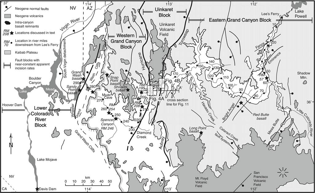
History of Quaternary volcanism and lava dams in western Grand Canyon based on lidar analysis, 40Ar/39Ar dating, and field studies: Implications for flow stratigraphy, timing of volcanic events, and lava dams - http://geosphere.gsapubs.org/content/4/1/183.abstract
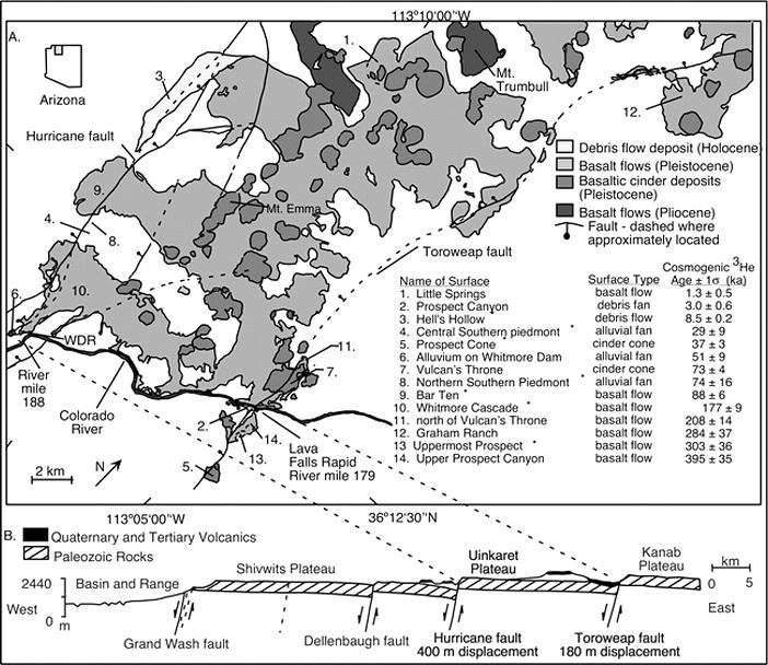
A synthesis of the geochronology on basalt flows from the southern Uinkaret volcanic field indicates that basalts erupted within and flowed into Grand Canyon during four major episodes: 725–475 ka, 400–275 ka, 225–150 ka, and 150–75 ka. To extend the usefulness of these dates for understanding volcanic stratigraphy and lava dams in western Grand Canyon, we analyzed light detection and ranging (lidar) data to establish the elevations of the tops and bottoms of basalt-flow remnants along the river corridor. When projected onto a longitudinal river profile, these data show the original extent of now-dissected intracanyon flows and aid in correlation of flow remnants. Systematic variations in the elevation of flow bottoms across the Uinkaret fault block can be used to infer the geometry of a hanging-wall anticline that formed adjacent to the listric Toroweap fault. The 725–475 ka volcanism was most voluminous in the area of the Toroweap fault and produced dike-cored cinder cones on both rims and within the canyon itself. Mapping suggests that a composite volcanic edifice was created by numerous flows and cinder-cone fragments that intermittently filled the canyon. Reliable 40Ar/39Ar dates were obtained from flows associated with this period of volcanism, including Lower Prospect, Upper Prospect, D-Dam, Black Ledge, and Toroweap. Large-volume eruptions helped to drive the far-traveled basalt flows (Black Ledge), which flowed down-canyon over 120 km. A second episode of volcanism, from 400 to 275 ka, was most voluminous along the Hurricane fault at river mile 187.5. This episode produced flow stacks that filled Whitmore Canyon and produced the 215-m-high Whitmore Dam, which may have also had a composite history. Basaltic river gravels on top of the Whitmore remnants have been interpreted as “outburst-flood deposit” but may alternatively represent periods when the river established itself atop the flows. Remnants near river level at miles 192 and 195, previously designated as Layered Diabase and Massive Diabase, have been shown by 40Ar/39Ar dating to be correlative with dated Whitmore flow remnants, and they help document the downriver stepped geometry of the Whitmore Dam. The ca. 200 and 100 ka flows (previously mapped as Gray Ledge) were smaller flows that entered the canyon from the north rim between river mile 181 and Whitmore Canyon (river mile 187.5); they are concordant with dates on the Whitmore Cascade as well as other cascades found along this reach. The combined results suggest a new model for the spatial and temporal distribution of volcanism in Grand Canyon in which composite lava dams and edifices, that were generally leaky in proximal areas, were built from 725 to 475 ka near Toroweap fault and around 320 ka near Whitmore Canyon. New data on these and other episodes present a refined model for complex interactions of volcanism and fluvial processes in this classic locality. Available data suggest that the demise of these volcanic edifices may have involved either large outburst-flood events or normal fluvial deposition at times when the river was established on top of basalt flows.
http://en.wikipedia.org/wiki/South_Rim - Grand Canyon
http://en.wikipedia.org/wiki/Lava_flow
http://en.wikipedia.org/wiki/List_of_volcanoes_in_the_United_States_of_America - List of volcanoes in the United States
http://tucsoncitizen.com/wryheat/tag/arizona/ sanfrmnt
http://tucsoncitizen.com/wryheat/tag/pinacate/ -az
http://www.library.illinois.edu/gex/bibs/geol315-415ariz.html
http://volcanology.geol.ucsb.edu/hydro.htm hydrovolcano
Pinacate Volcanic Field (PI) Most of the Pinacate volcanic field is in Sonora, just south of the Arizona border. Pinacate contains eleven giant-maar craters and hundreds of cinder cones. (See photos here and here.) The field has been active for 2 or 3 million years and eruptions have occurred as recently as 13,000 years ago
http://vulcan.wr.usgs.gov/Volcanoes/Arizona/framework.html
Arizona Volcanoes and Volcanics
next
Continuing Colorado plateau uplift by delamination-style convective lithospheric downwelling
Uinkaret volcanic field and the Grand Canyon area