 | New Mexico Volcanoes |
Virtual view of New Mexico geology from space (created using NASA''s World Wind software -http://geoinfo.nmt.edu/tour/home.html |
Physiographic map of New Mexico (modified from Wilks, 2005).http://geoinfo.nmt.edu/tour/home.html |
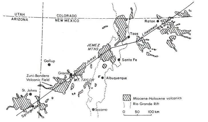
emez Lineament. The Jemez Lineament is a major flaw in the EarthÆs crust along which volcanoes have erupted for the past 16 Ma. This northeast trending string of young volcanoes includes, from the southwest to northeast, the Springerville volcanic field, the Malpais basalt field, Mt. Taylor, Valles Caldera, Taos Plateau volcanic field, the Raton-Clayton and Ocate volcanic fields. It has been suggested that this linear pattern of volcanism, [Jemez Lineament], exists because magma has leaked upward along a zone of weakness in the crust (Bauer etal, 2003). But another theory suggests that the North American plate moved over a hot spot the same way that the Hawaiian Islands formed. However, because of the directional movement of the North American plate, if this theory were correct it would mean that all the volcanoes in the northeast section of the Lineament would be younger than those to the southwest. As it is, all the volcanoes in this grouping are around the same geological age. -http://www.anthro4n6.net/bandera/ |
Miocene to Holocene volcanic fields and the Jemez lineament. From Ander and others (1981).1Springerville 2 Zuni-Bandera 3 Mount Taylor 4 Jemez Mountains 5. Taos 6 Ocate 7 Raton-Clayton http://library.thinkquest.org/C0112681/Eng/Normal/Volcanoes_World/north_america/new_mexico/mccartys_flow.html |
Springerville volcanic field |
Springerville volcanic field |
Springerville volcanic field |
http://www.anthro4n6.net/bandera/ - Zuni-Bandera Volcanic Field. This is a satellite image of the Zuni-Bandera volcanic field. The image is oriented north-south, and is about 100 km (60 miles) along the north-south axis. The lava flows in this image are represented by black, grey, or reddish brown color, and cover much of the central and lower left part of the image. The age of the lava flows can be roughly estimated by the color, with the blacker flows being younger than the redder ones. The McCarties and Bandera flows, around 3 ¢ 10 KY, respectively, account for much of the black color on the map. Other features that can be seen are the town of Grants, shown mainly in blues and greens, and the topographic feature, Zuni Canyon. Highway 40 can be seen as a dark blue line just south of Grants. Approximately 100 volcanoes have been identified in the Zuni-Bandera volcanic field (Laughlin etal, 1993)- http://geoinfo.nmt.edu/tour/federal/monuments/el_malpais/zuni-bandera/satellite.html,http://geoinfo.nmt.edu/tour/federal/monuments/el_malpais/zuni-bandera/images/satellite-big.jpg. The Zuni-Bandera lava field in western New Mexico forms part of the Jemez volcanic lineament. The field occupies a large valley south of Grants, New Mexico, and is bounded to the west by the Zuni uplift. Stretching 90 km long and 1 to 35 km across, it covers an area of 2,460 km2 with a composite thickness of 20 to 60 m of lava. Between 62 and 123 cubic kilometers of lava was erupted from 74 vents that tend to be aligned along faults and fissures. ... Various names have been applied to the field including Malpais, McCartys, Zuni, and Bandera. The Zuni-Bandera volcanic field provides excellent examples of a variety of vent types and lava flow morphologies. Eruptive centers, and pyroclastic activity, are marked by cinder cones, spatter ramparts and cones, small shields, maars, and collapse pits. Lava flows exhibit pahoehoe, aa, and block surface textures and may be extremely long, as exhibited by the 90-km-long Fence Lake flow to the west and the 60-kilometer-long McCartys flow to the east. Lava tubes up to 28.6 km long form some of the most struking morphological features within the field. These tubes are restricted to pahoehoe flows but are not limited to a specific lava composition. Other surface morphologies indicative of tube-fed lava characterize some of the flows and include pressure ridges, tumuli, linear squeezeups, grooved lava, and collapse pits - http://vulcan.wr.usgs.gov/Volcanoes/NewMexico/description_new_mexico_volcanics.html |
This is a geologic map of the Zuni-Bandera volcanic field. The map is oriented north-south, and is about 100 km along the north-south axis. The lava flows in this image are represented by the colored areas on the map which cover much of the central and lower left part of the map. Vents are shown as black stars, and are labelled for most colored flows. The age of the lava flows can be determined by the scale, with the younger flows being red, and the oldest grey. You can aget a file of the map for printing - http://geoinfo.nmt.edu/tour/federal/monuments/el_malpais/zuni-bandera/geolmap.html , http://geoinfo.nmt.edu/tour/federal/monuments/el_malpais/zuni-bandera/geolmap.html. The Zuni-Bandera volcanic field, in northwest New Mexico, has had many episodes of basaltic eruptions over the last million years (Laughlin et al., 1993). The youngest lava flow in the field is the McCartys flow, which is only 3000 years old, one of the youngest volcanic features in the 48 contiguous United States! The Zuni-Bandera volcanic field has produced many basaltic lava flows, some with a-a characteristics, and some that are paheohoe. There are also a number of well-preserved cinder cones that can be visited, as well as many lava tubes, some of which contain perennial ice. The Zuni-Bandera volcanic field is an excellent site for studying physical volcanology of basaltic magmatic systems.The Zuni-Bandera volcanic field consists of a large number of basaltic lava flow and cinder cones, and exhibits a number of striking features of hawaiian-style volcanism. Pahoehoe and a-a lavas are both represented, along with well-developed lava tube systems. Nichols (1946) mapped and catalogued the geomorphic features of the apparently-young McCartys basalt flow and recognized many features of Hawaiian-style volcanism, including pahoehoe flow patterns, small spatter cones, gas cavities, large wedge-shaped cracks, collapse depressions, large pressure ridges and tumescences. These types of features are also present in other, apparently-older flows, although in some cases are obscured by erosion. At least 100 vents have been recognized in the volcanic field (Luedke and Smith, 1978), and the flows cover a large aerial extent of 2,460 km2. Combined flow thickness is as great as 145 m in some places, and the total volume of all flows is at least 74 km3 (Laughlin et al, 1993).The Zuni-Bandera volcanic field volcanism occurs along the Jemez linament, a zone of apparent crustal weakness defined by a concentration of late-Cenozoic volcanism (Laughlin et al., 1982). The Zuni Bandera volcanic field also occurs in a "transition zone" between the Colorado Plateau, with crustal thicknesses of over 40 km to the Rio Grande Rift where the crust is much thinner. The Jemez linament trends north-northeast, and includes the Zuni-Bandera volcanic field, the Mt. Taylor volcanic field, and the Jemez volcanic field. The Jemez linament apparently has been a long-lasting tectonic feature that penetrates the lithosphere to great depth, and the basaltic lavas of the Zuni-Bandera volcanic field appear to be mantle-derived melts (Laughlin et al., 1982). Geochemically, the lava flows of the Zuni-Bandera volcanic field include both tholeiitic, alkaline basalts as well as minor basaltic andesites and one basanite (Menzies et al., 1991). Observed phenocryst mineralogy includes small olivine crystals, plagioclase crystals and pyroxene. Groundmass contains the same phenocrysts phases, as well as opaque oxides (Laughlin et al., 1972). Feldspar megacrysts, composed either of anorthoclase or oligoclase, are present in some of the alkali basalt flows. These megacrysts can be up to 2 cm in diameter (Laughlin et al., 1974). |
The Bandera crater. This photo shows a line of cinder cones looking south from Bandera Crater. In the left of the picture is a cinder cone and to the right of the picture is a more distant cinder cone. Further to the right but not in the picture are several very close cinder cones. In the far distance are several more cinder cones stretching further away with about 15 different cones visiblecrustoxidizedfragments.http://geoinfo.nmt.edu/tour/federal/monuments/el_malpais/zuni-bandera/cinder_cone.html. |
The Bandera crater. From Bandera Crater, a number of other cinder cones are visible. This photo shows the two nearby cones. These cinder cones make up a feature called the "Chain of Craters", that is well-marked on the geologic map. The alignment of these cones would be cause by a linear weakness in the earth''s crustoxidizedfragments.http://geoinfo.nmt.edu/tour/federal/monuments/el_malpais/zuni-bandera/cinder_cone.html. |
Bandera Crater - Bandera Crater and Ice Cave is a volcanic area. - particular area is known as The Northern Chain of Craters. It lies along the Jemez Lineament within the El Malpais and Zuni-Bandera Volcanic Field at the southeastern tip of the Zuni Mountains near Grants, NM. Bandera Crater is one of the largest of the cinder cones in this region and an ideal example of a breached cone). It rises 180 m high and has a central depression 230m below the rim. There is a 80 m breach on the southwestern side of the cone. According to Maxwell, the name ōBanderaö is derived from a flag mounted on the summit by soldiers but it is not clear if this flag was raised on Bandera Crater or on Cerro de la Bandera or both. The third youngest eruption in New Mexico, the Bandera Crater area is a great example of a variety of volcanic features including lava flow structures, openings to lava tubes containing ice and both pahoehoe and aa lava types (Crumpler and Aubele, 2001). ōA large lava tube begins at the breach and extends to the south and east for 12 miles and may continue as far as 18 miles from the craterö (Maxwell, 1989). ōBecause of the youthfulness of these lava flows, they are well preserved with spectacular views of volcanic landforms and provide the geologist with an ideal area for investigating volcanic processesö (Laughlin etal, 1993). - http://www.anthro4n6.net/bandera/ The following images were taken as part of the Rockin'' around New Mexico meeting, held in Grants, New Mexico. A number of interesting features are associated with the 10 KYr old Bandera Crater eruption. In addition to the cinder cone, discussed on a different page, the Bandera Crater eruption produced aa lava, collapse pits, spines, spatter cones, and lava tubes, one of which contains perennial ice. In contrast to pahoehoe lava, aa has a very loose and rubbly surface. Aa flows form from lava that is more viscous than pahoehoe.Bandera Crater is a cinder cone similar in appearance to the cone shown in the image to the left, which is Lost Woman cone just to the north of Bandera Crater. Cinder cones are formed by pyroclastic eruptions that throw fragments of hot lava into the air. The shape of a cinder cone is typically affected by the prevailing wind, with the higher part of the cinder cone on the upwind side, and the lower part, usually containing the breach on the downwind side - http://geoinfo.nmt.edu/tour/federal/monuments/el_malpais/zuni-bandera/cinder_cone.html. |
Cinder cones are formed by pyroclastic eruptions that throw fragments of hot lava into the air. As long as the vent continued to fountain out cinder, the cone continued to grow. Eventually, the composition of the lava may have changed slightly (became less volatile) thus changing the nature of the eruption. At this point the crater began to fill with lava, creating a lava lake |
See good photos - http://www.anthro4n6.net/bandera/photos.html |
The Bandera flows originated from Bandera Crater, a double cinder cone about 150 m high and 1 km in diameter. The eruption of Bandera Crater and its associated flows was the second youngest volcanic event in the ZBVF. Like many other cinder cones in the ZBVF, Bandera Crater is breached to the southwest, probably due in part to local prevailing winds. A large lava tube, intermittently collapsed, extends about 29 km south from the breach in the crater wall and a commercial ice cave is located in a collapsed portion of the tube near the Candelaria Trading Post. Causey (1970) recognized seven stages in the development of Bandera Crater and its associated flows, culminating in the eruption of the black cinders that cap the cinder cone and blanket the hills to the north. Two small commercial cinder pits have been opened in the cinders covering the hills to the north of NM Highway 53 where the cinder blanket is thickest. A variety of crustal and mantle xenoliths and anorthoclase megacrysts have been found in these cinder pits (Laughlin et al., 1971, 1974; Gallagher, 1973). The Bandera lavas are nepheline normative, holocrystalline, microporphyritic and vesicular near the surface. Both aa and pahoehoe surfaces are common on the flows. These dates of 0.199 and 0.148 +/-0.8 MA provide maximum ages for the Bandera flows. These ages were suspected of being too old due to the possible prescence of excess Ar in the samples. Since then, charcoal collected from under the cinders, and presumably carbonized by the eruption, yielded ages of 10.05-10.07 ka (Laughlin et al., 1994). The 40Ar/39Ar technique yielded an age of 41 +/-7 ka, probably much older than the actual eruption age due to excess Ar in the samples. In summary, the Bandera crater cinders and lava flows probably erupted around 10 KA.The lava lake was not contained within the crater for long. Soon the lava breached the crater''s lowest wall (the southern portion) and flowed through to create the voluminous lava flow spreading out and away from Bandera Crater.As this lava flowed, it created a huge lava tube, the evidence of which we see as the deep gully in the bottom of this picture.To the left of the picture is a thick basalt flow located just below the western portion of the crater rim. This flow marks where the surface of the original basalt flow (the one which formed the roof of the lava tube nearest the crater) was located with respect to the cinder cone.Eventually the flow was in the gigantic tube subsided and the roof, no longer gaining support from the flow, collapsed - http://geoinfo.nmt.edu/tour/federal/monuments/el_malpais/zuni-bandera/background.html#Bandera http://geoinfo.nmt.edu/tour/federal/monuments/el_malpais/zuni-bandera/cinder_cone.html. |
The Bandera crater. This photo shows "welded spatter". During some parts of cinder cone eruption, the cinders are still partially molten when the hit the ground. In this case, they can stick together, or weld after deposition. Cinder cones are typically made up of some welded, and some non-welded layers. Welded or non-welded cinders can be either red or black, depending on the degree to which iron (Fe) in the cinders has been oxidizedfragments.http://geoinfo.nmt.edu/tour/federal/monuments/el_malpais/zuni-bandera/cinder_cone.html |
The Bandera flows This photo shows bedded cinders. Within the population of cinders, the larger and heavier are the first to fall and smaller ones fall later, leading to graded bedding of these pyroclastic fragments.http://geoinfo.nmt.edu/tour/federal/monuments/el_malpais/zuni-bandera/cinder_cone.htmlRocks are vesicular due to expanding gases erupting. Dark color due to minerals dominated by Fe and Mg. No crystals seen because of rapid cooling. Sizes of most pyroclastics in picture are ranging from lapilli (2-64mm) to bomb size (764mm). Gases (volatiles) expand in magma as it rises to the earth''s surface via conduits |
Bandera Crater. This photo shows a spatter cone, which is a feature seen on some basaltic lava flows. This is not an actual vent, but is a feature that may have formed when the lava flow moved across a damp or wet earth, generating steam which exploded up through the flow. Another possible mechanism by which this feature could have formed is by overpressured magma escaping through a fissure in the cooled top of a lava flow. http://geoinfo.nmt.edu/tour/federal/monuments/el_malpais/zuni-bandera/aa-ice.html |
Bandera Crater. Volcanic spine probably caused by slowly flowing, viscous aa lava. When the front stopped, the flow behind back up against it, building up pressure and pushing up the spine. This feature is not a vent, but simply a part of the aa flow. This type of spine is not likely to be observed in less viscous pahoehoe lava, but a "squeeze-up" is a similar, but much smaller feature that form by a similar mechanism in pahoehoe- http://geoinfo.nmt.edu/tour/federal/monuments/el_malpais/zuni-bandera/aa-ice.html |
Bandera Crater This lava field is made up of aa lava. Aa lava is composed of jagged, broken lava produced when the surface of the flow cools and hardens while underlying lava is still in motion.There are a variety of trees and shrubs covering the field that include salt cedar, juniper, ponderosa pine and sage.- http://geoinfo.nmt.edu/tour/federal/monuments/el_malpais/zuni-bandera/aa-ice.html |
Bandera Crater. This photo shows the difference between aa and pahoehoe lava flows. The aa areas are the rubbly-looking areas on the photo, whereas pahoehoe of the same age is smoother and more vegetated. The surface of the aa is loose and rubbly. This photo is not of the Bandera flow, but rather of the less-vegetated McCartys flow - http://geoinfo.nmt.edu/tour/federal/monuments/el_malpais/zuni-bandera/aa-ice.html |
Bandera Crater. Lava flows have been used by past civilizations. Here, is a circular stack of lava forming an Anasazi ruins. Lava has excellent insulating properties and therefore was good to use in shelters, especially those shelters used in areas of rapid temperature changeshttp://geoinfo.nmt.edu/tour/federal/monuments/el_malpais/zuni-bandera/aa-ice.html |
Levels of lava flows preserved as shelves on the wall of the Four Windows Cave, a partially collapsed lava tube in the Big Tubes Area on the west side of El Malpais National Monument. |
Lava drip marks on a roof block on the floor of the Four Windows Cave -http://www.denison.edu/academics/departments/geosciences/fieldtrips/may_2001_field_trip.html |
http://www.icecaves.com/ |
Candelaria Ice Cave . There are many ice caves in the collapsed lava tubes of the Malpais volcanic fields but none as accessible as the Candelaria Ice Cave at Bandera Crater. Just a short hike from the cinder cone, the ice cave is set in the exposed walls of the lava tube. The ice is green because of the algae that grows there. ōThe Ice Cave, which is quite small, maintains its low temperature because of the low average yearly temperature at this altitude and latitude, the character and direction of the opening, the shape of the floor of the cave at the opening and the direction of the prevailing winds. These factors help to prevent the circulation of air, and cold air (which is heavier than warm air) remains in the caveö (Foster, 1971). Water freezes in the cave during the winter and the resulting ice helps maintain the cold temperature during the summer. ōAlthough the cave opening is to the south, the size, angle, and direction of the opening are such that sunlight reaches the base of the ice wall for only a few minutes a day from about the 16th through the 26th of Decemberö (Foster,1971). ōTandem Mass Accelerator radiocarbon 14C dates were obtained from a moth, two twigs, one feather, and CO2 gas from four ice samplesö (Mabery, K., 1997). Based on these tests, it is possible that the bottom of the ice cliff may be 1800 to 3000 years old with a gap of between 1500 and 2000 years before the modern ice formed. It is possible that erosion through ablation could have caused this ōhiatusö in ice formation (Mabery, K., 1997)- http://www.anthro4n6.net/bandera/icecave.html. |
Perennial ice in a deep lava tube. As we went down into the ice cave temperature dropped from 40oC to ¢ 3oC. Moss was growing towards mouth of cave. It was approximately 4 to 5m wide. The floor was covered with ice, some parts had a green tinge, indicating that moss or algae may have grown in ice. The ice floor was probably developed from the water dripping from ceiling and precipitation from past snow or rain draining into cave. There is a gap developed in back center of the cave. In 1940 pictures, there is no gap.In 1996 pictures, the gap has begun to developedNow, gap is more profound.Wall of ice along back of cave approximately 1 to 2m wide (Now) - http://geoinfo.nmt.edu/tour/federal/monuments/el_malpais/zuni-bandera/aa-ice.html |
http://www.ees1.lanl.gov/Wohletz/Quaternary_basalt.pdf |
McCartys shield Pahoehoe sheet flows - http://www.psi.edu/pgwg/images/Oct11Image.html |
McCarty flow approximately 3, MY old, and is mainly composed of pahoehoe lava. Edge of pressure (fissure) ridge. Local vegetation is salt bush.Pahoehoe lava flows form from very fluid basaltic lava, and have characteristic smooth, billowing, or ropey crusts of quenched glass over more crystalline flow interiors (Williams and McBirney, 1979). Many of the features observed in pahoehoe lava flows are related a process whereby hot, fluid lava flows under and drags, or inflates and splits, the partially cooled crust. Ropes are formed by the cooled surface being dragged, and deformed by hotter, flowing lava. Fissures and tumescences can be formed by hot lava flowing under, inflating and cracking a cool, brittle crust. Squeeze-ups can be formed when hot lava is squeezed up through a small fissure, or hole in the cool crust. The following photos illustrate a number of features that can be observed on the McCartys lava flow near - http://geoinfo.nmt.edu/tour/federal/monuments/el_malpais/zuni-bandera/pahoehoe.html McCartys flow is the youngest basalt flow within the Zuni-Bandera volcanic field. A small cinder cone about 8 m high sits on top of this broad shield. Although some of the lava flowed southwestward 8 to 9 km, most followed the preexisting drainage and flowed northward about 40 km before turning to flow eastward 10 km down the Rio San Jose valley. The McCartys flow overlies older basalts of the Zuni-Bandera volcanic field and Holocene alluvium.The McCartys flow is typically a vesicular, porphyritic basalt. Carden and Laughlin (1974) examined chemical and petrographic variations along the length of the flow and reported that within 4 km of the source the basalt is characterized by plagioclase phenocrysts 0.20 to 1.5 cm in length. At greater distances from the source, large plagioclase phenocrysts are absent and olivine phenocrysts are present. Plagioclase is the dominant mineral in samples of McCartys flow.Prior to work of Laughlin et al. (1994) and others, the age of McCartys flow was poorly constrained. Nichols (1946), on the basis of Indian legends and archeological and faunal evidence concluded that the McCartys eruption probably took place after 700 A.D. Since then, accelerator mass spectrometer radiocarbon dates of 2970 and 3010 +/-70 years B.P. were obtained on samples of burnt roots. The determined ages are 2.5 and 3.9 - http://geoinfo.nmt.edu/tour/federal/monuments/el_malpais/zuni-bandera/background.html#Bandera. |
The edge of the McCartys flow. A number of features can be observed at this location: thick ropy pahoehoe lava with a steep front that formed while the flow was active, patches of reddish-brown oxidation - related to oxidation of iron within the flow, or to oxidation of windblows dust that accumulated in the flow after eruption, glassy, shiny black material indicating young flow (glossy black sheen). The (1/2") dense crust with few scattered random vesicles over vesicular core with tan, reddish-brown and rare bluish sheen in glassy areas, small scale fissure, tiny/big cracks vertically/horizontally, vegetation in cracks: Apache Plume, vegetation on surface: red and green lichen, vegetation on edge: New Mexico Olive, vegetation on edge: native grasses, Phenocrysts not visible with naked eye. Olivine, pyroxene, and plagioclase are likely to be present. Some individual crystals are visible with hand lense - - http://geoinfo.nmt.edu/tour/federal/monuments/el_malpais/zuni-bandera/pahoehoe.html |
actively flowing pahoehoe |
A close-up view of the McCartys flow front:The crusted ropy flow exhibits a glassy, black, shiny appearance. The texture is very rough. The glassiness indicates this flow is fairly young, about 3 KY.A closer examination displayed a black outer layer and an inner tan and gray core full of air bubbles. There were also tiny holes and fissures on the outer surfaces. The fissures did not show much glassiness.A few tiny crystals were observed on the glassy crust using a magnifying lens. In a tiny crevice of the glassy crust, a bluish, purple sheen was observed.Apache plume, New Mexico plumes and blue gramma grass were observed growing next to the frontal flow- - http://geoinfo.nmt.edu/tour/federal/monuments/el_malpais/zuni-bandera/pahoehoe.html |
McCarty flow . This picture shows a fissure, a place in this pahoehoe lava flow where magma broke through the already hardened surface. The surface of the flow at this point is relatively smooth, but the fissure itself is cracked and jagged. Cacti and other plants are growing on the surface of the flow. Lichen, cacti, and other plants are growing inside the fissure -http://geoinfo.nmt.edu/tour/federal/monuments/el_malpais/zuni-bandera/pahoehoe.html |
a view of an active fissure |
McCarty flow. This photo shows the details of the inner part of a fissure in the surface of the lava. This part of the lava flow pressure ridge shows a central rupture. The orientation of the fissure was estimated to be N 45o W. The fissure''s opening was about 4''-0" wide and ranged from 4''-0" to 7''-0" deep, and was an estimated 8m in length. Five (5) flow strata were observed on the ruptured wall. Because both of the ruptured walls displayed a surface-to-depth breaking pattern that was as smooth as lava breaks go, I believe that differential cooling of the pressure ridge can be ruled out as the engine for this fissure. A possible explanation for the formation of the fissure would be inflation of the cooled surface by underlying hot lava.-http://geoinfo.nmt.edu/tour/federal/monuments/el_malpais/zuni-bandera/pahoehoe.html |
McCarty flow. This picture shows a fissure in pahoehoe lava, and illustrates a feature called "vesicle stratigraphy". Vesicles are gas bubbles in volcanic lava or rock. While the lava is flowing and liquid, vesicles will migrate up through the flow, leaving denser lava at bottom and more vesicular lava at the top.At the base it is denser with few vesicles. Above it is a band of many vesicles with a large gas cavity. At the top the vesicles are smaller.Looking south, pen as scale: This is a pahoehoe lava flow, which was cooler on the surface, forming this feature. A fissure divides the two halves of the formation http://geoinfo.nmt.edu/tour/federal/monuments/el_malpais/zuni-bandera/pahoehoe.html |
McCarty flow. This picture illustrates a small fissure that formed in the surface of an active flow. The pahoehoe ropes on the upper surface are well displayed http://geoinfo.nmt.edu/tour/federal/monuments/el_malpais/zuni-bandera/pahoehoe.html |
McCarty flow. This picture illustrates a small fissure that formed in the surface of an active flow. This would be a smaller example of the fissure shown in the previous picture. One possible mechanism that could have formed this fissure would have been if hot lava caused inflation of an already-cool and brittle crust of cold lava. The inflation could have caused the splitting, or fissuring, to occur. Ropes on the two sides of the fissure match perfectly, indicating that no lateral movement occurred during fissuring http://geoinfo.nmt.edu/tour/federal/monuments/el_malpais/zuni-bandera/pahoehoe.html |
Upon first sight, the collapsed pit is not noticeable due to New Mexico Olive in front. Further inspection showed how the top of the lava flow has collapsed to the soil level below. The layers from subsequent flows are apparent in the collapse face. If the Olive were not present, the pit would appear as a cave in the flow face. The thickness of the original lava flow surface was thin here, probably one foot or less. As the thin lava crust, probably overlying a lava tube, cooled, is could have fractured and collapsed. Once the initial collapse occurred larger sections are more open to weathering causing fracturing and collapse of these sections, also. This collapse feature is similar to the opening to many lava tubes. http://geoinfo.nmt.edu/tour/federal/monuments/el_malpais/zuni-bandera/pahoehoe.html |
McCarty flow. This photo illustrated a "squeeze up", where hot lava is pushed out through a small fissure in a cooled lava crust. The squeeze up is a bit difficult to see in this photo, but is right above the notebook. The squeeze-up is protruding out, and leaning towards, the viewer, and can be seen better in the larger verion of the photo (click on the small version to get there). The SWside of the S-U/wall contact was free of lava debris and was easily observed; however, broken wall material did not permit the NE S-U/wall contact zone to be viewed. Striae on both sides of the McCarty squeeze up were prominent and very well formed, and along part of the SW wall zone, it appeared that some of the earlier solidified striae-causing lava was still in place. The lava source for this squeeze-up was probably an underlying, yet-to-be located lava tube.http://geoinfo.nmt.edu/tour/federal/monuments/el_malpais/zuni-bandera/pahoehoe.html |
Lava tubes are a very interesting feature of basaltic lava flows. As basaltic lava cools, the outer part can solidify to form a shell around the inner, still molten and flowing part. The cool crust acts as a very effective insulator for the inner, hotter lava, allowing it to flow for very great distances, and greatly extends the distances over which basaltic lava flows can travel. Single lava tubes up to 10 km in length have been recognized in Hawaii (Francis, 1993). Lava tubes have been recognized in many parts of the world, and also may have been recognized on giant Martian volcanoes (Francis, 1993). The following photos illustrate a number of features observed in a lava tube called Junction Cave near Grants, NM. This photo shows the northwest opening of Junction lava tube, looking from the northwest toward the main entry on the southeast (where people are standing). This photo give an idea of the trend of the lava tube. The two entrances are two collapsed portions of the lava tube. Vegetation on the lava is rooted in several inches of reddish sandy windblown dust, suggesting that the flow is older than the McCarties flow. Plants include juniper, piсon pine, ponderosa pine, Apache plume, rubber rabbit brush, Indian paintbrush, prickly pear cactus as well as several grass species. Lava at the surface is considerably weathered showing no volcanic glass on its surface indicating a lava flow old enough for weathering of the surface to have occurred ----http://geoinfo.nmt.edu/tour/federal/monuments/el_malpais/zuni-bandera/lava_tube.html |
The Junction Lava tube. When the lava tube emptied, the lava on the ceiling solidified and contracted upon cooling. This contraction form fractures in the lava and large blocks subsequently fell from the ceiling. If another lava flow had occurred through the same tube, the new lava flow would have pushed these blocks along with it, rounding the blocks into lava balls. Looking Outward Toward Junction Cave Opening from the Inside. The relatively small (2-meter high by 5-meter wide) opening to this dendritic lava tube system is silhouetted against the dark basaltic walls, roof, and floor of the Junction Cave. Note numerous large blocks, which have dropped off the roof and now fill the bottom of the cave interior, which might once have been more than 10 meters high and 15 meters wide. About 100 meters from the Entrance:Junction Cave is actually a complex dendritic lava tube system more than 400 meters long, with several branching sub-tubes (hence the designation "dendritic"). Among the unique features formed naturally in large lava tubes found in the Malpais are: "tube lining," which look like glazed elephant skin; lateral "side benches" formed by multiple flows at different levels; "curl-down" caused by highly plastic cave wall lining breaking loose, with its top sagging inward; and fallen "roof blocks" some of the size of refrigerators, which have become unattached as a result of internal gravitational mass wasting.http://geoinfo.nmt.edu/tour/federal/monuments/el_malpais/zuni-bandera/lava_tube.html |
The Junction Lava tube. The side of the lava tube illustrates that pahoehoe lava flows can be made up of many thin flows, rather than a single, thick body. In this photo, it appears that at least 5 thin flows are present, the breaks between flows being demarcated by the presence of the vesicular (bubbly) horizons that form at the top of a lava flow. Pahoehoe flows are not nececessily perfectly flat, but can be lobate. A possible lobate flow tongue can be seen half way up the right-hand side of the photo. http://geoinfo.nmt.edu/tour/federal/monuments/el_malpais/zuni-bandera/lava_tube.html |
This photograph also illustrates the presence of multiple pahoehoe flows, but viewed from beneath, rather than from the side. The vesicular top of the underlying flow can be seen as the reddish areas on the photo. The overlying flow is the blacker material. The overlying flow was apparently very fluid when it was emplaced, because it conforms smoothly to the top of the underlying flow .http://geoinfo.nmt.edu/tour/federal/monuments/el_malpais/zuni-bandera/lava_tube.html |
Bandera offers cinder cones, spatter cones, collapsed lava tubes and ice caves formed from these tubes. BanderaÆs eruption was a ōpassive type which produced lava flows and small cinder cones. This type of eruption is generally known as Hawaiian, because it is the type of activity that formed and continues to form the Hawaiian Islands. These volcanic rocks are called basalts and are typically black in colorö (Dunbar, 2001). ōCinder cones are the result of very explosive eruptions which fragment the magma into small cindersö (Mabery, K., 1997). During volcanic eruptions, gas-rich alkalic basalts cause foamy lava to shoot high into the air and, cooling as they fall, pile up to form cones of loose particles. ōCinder cones produced by the eruption of alkali basalt are identified by their conical shape and central depressions called cratersö (Mabery, M., 1999). ōSpatter cones are similar to cinder cones, but the pieces of lava are larger, called bombs. When these pieces hit the ground they are still hot and plastic enough to deform and weld togetherö (Mabery, K., 1997). Spatter is from the lowest energy eruptions (Mabery, M., 1999). The cinder cone at Bandera is a breached cone, but it did not breach as a result of a later eruption; rather, it was formed that way. According to M. Mabery, the lava flow began welling upward, moving down slope and moved laterally at the same time as the ōbeginning of the vertical, gas-rich, jetting phases of the eruption that produce cinders and spatters.ö The resulting lava flow carries away parts of the cone, especially if the amount of eruption suddenly increases. Part of Bandera CraterÆs rim came to rest about 1.8 km from the main crater due to this ōraftingö of lava. Lava tubes like the one that is now known as the Candelaria Ice Cave are formed when ōan active low-viscosity lava flow develops a continuous and hard crust, which thickens and forms a roof above the still flowing lava stream. They are natural conduits through which lava travels beneath the surface of a lava flow, expelled by a volcano during an eruption. They can be actively draining lava from a source, or can be extinct, meaning the lava flow has ceased and the rock has cooled and left a long, cave-like channelö. One might believe that Bandera crater was part of the Mt. Taylor eruptions; however Mt. TaylorÆs main episode was around 3.3 MA with other major eruptions occurring around 2.5 MA. Bandera is only about 10 KY and the even younger Malpais eruptions only occurred 3.5 KA. Bandera is a very young flow and is ōvoluminous, covering large areas with the [El Malpais] national monumentö (Laughlin, 1994). The Zuni-Bandera volcanic field ōoverlies a section of Permian ¢ through ¢ Mesozoic-age sedimentary rock units, which are exposed along the flanks of the Zuni Uplift . The area in which Bandera Crater lies has been active from around 4 MA to just 1KA. According to Ander and Huestis (1982), an anomalous body lying beneath the Zuni-Bandera field is believed to be a mafic intrusion no deeper than 5.25 km with a minimum thickness of 2 km. They suggest that this intrusion, however, did not cause the most recent volcanic activity in this region but ōpredated and controlled the Nutria monocline, a Laramide featureö Ander, etal, 1982). There were ōsix stages of development of the crater and its associated flows, culminating in the eruption of the black cinders that cap the cinder cone and blanket the hills to the northģ a variety of crustal and mantle xenoliths and anorthoclase megacrysts have been found in the cinder pits. Both pahoehoe and aa lavas are commonö (Laughlin etal, 1993). http://www.anthro4n6.net/bandera/geology.html http://www.anthro4n6.net/bandera/ - Zuni-Bandera Volcanic Field |
http://www.anthro4n6.net/bandera/ - Zuni-Bandera Volcanic Field |
The Bandera flows have been dated using 4 different techniques. The youngest possible age for these flows is 3,166 +/- 77 years and was ōprovided by a radiocarbon date on a twig enclosed in laminated ice from the Candelaria Ice Cave - http://www.anthro4n6.net/bandera/geochronology.html |
Zuni Mountains -http://www.anthro4n6.net/bandera/ |
Volcanic Field and Sandstone Cliffs at El Malpais National Monument - http://www.panoramio.com/photo/9168166 |
Zuni Salt Lake Maar - Volcanic maar north of Red Hill Maar, a shallow saline lake that occupies a flat-floored crater about 3km across and 130m deep. Its low rim is composed of loose pieces of basaltic lava and wallrocks (sandstone, shale, limestone) of the underlying diatreme, as well as random chunks of ancient crystalline rocks blasted upward from great depths http://vulcan.wr.usgs.gov/Glossary/Maars/description_maars.html, http://www.ees1.lanl.gov/Wohletz/Quaternary_basalt.pdf |
Also called "tuff cones," maars are shallow, flat-floored craters that scientists interpret have formed above diatremes as a result of a violent expansion of magmatic gas or steam; deep erosion of a maar presumably would expose a diatreme. Maars range in size from 200 to 6,500 feet across and from 30 to 650 feet deep, and most are commonly filled with water to form natural lakes. Most maars have low rims composed of a mixture of loose fragments of volcanic rock and rocks torn from the walls of the diatreme- http://www.ees1.lanl.gov/Wohletz/Quaternary_basalt.pdf |
http://www.ees1.lanl.gov/Wohletz/Quaternary_basalt.pdf |
http://www.ees1.lanl.gov/Wohletz/Quaternary_basalt.pdf, http://plate-tectonic.narod.ru/volcanoam6cphotoalbum.html |
http://geoinfo.nmt.edu/tour/landmarks/mt_taylor/home.html |
Mount Taylor volcanic field |
The Taos Plateau volcanic field is the most voluminous concentration of lavas along the axis of the Rio Grande rift, covering approximately 7,000 km2 and ranging from basalt to rhyolite. Despite their location in a well developed rift setting, the lava were erupted from monogenetic central volcanoes, including at least 35 shields and cones clustered within a 30x50-kilometer region of the central Taos Plateau. The larger volcanoes form an imperfect concentric pattern approximately 40 km in diameter: tholeiitic shields are located centrally within the volcanic field, andesite volcanoes at intermediate positions, and dacite farthest out. Two small silicic lava domes are also near the field''s center. Individual volcanoes tend to be petrologically uniform. Basaltic rocks are volummetrically dominant, and volumes of rock types decrease as the silica content increases. The Taos Plateau volcanic field fills the northern end of the Rio Grande rift valley, north-northwest of Taos -http://vulcan.wr.usgs.gov/Volcanoes/NewMexico/description_new_mexico_volcanics.html, http://www.westerngeohikes.0catch.com/NewMexico/West_of_Questa.html |
Taos. The Taos area straddles the boundary between three geographic/geologic terrains and the faults that define their boundaries. The Sangre de Cristo Mountains and Picuris Mountains are split by the Picuris-Pecos fault system. The Sangre de Cristo Mountains and San Luis Basin are separated by the Sangre de Cristo fault zone, and the Picuris Mountains and the San Luis Basin are separated by the Embudo fault zone.The Picuris-Pecos fault zone consists of a complex series of parallel north-striking, vertical to near-vertical faults that cut Precambrian through early Tertiary rocks in the Taos area. Presumably, the Picuris-Pecos fault extends northward into the basin, but is buried by the younger alluvium.The Embudo fault zone is a complex system of left-oblique, north-down, strike-slip fault strands that is over two kilometers wide. We have defined the terminus of the Embudo fault at the Rio Grande del Rancho, where the dominantly strike-slip, east-striking Embudo fault system swings northward and merges with the dominantly dip-slip Sangre de Cristo fault. A variety of physical features help to define fault scarps and photolineaments along the Embudo fault zone. These include springs and deciduous trees such as willows and cottonwoods. - http://geoinfo.nmt.edu/geoscience/projects/astronauts/geologic-setting.html#generalGeo |
The Raton-Clayton volcanic field http://www.mountain-forecast.com/peaks/Raton-Clayton-volcanic-field. The Raton-Clayton volcanic field, in the extreme northeastern corner of New Mexico, is Pliocene to Holocene in age. Approximately 120 basaltic to nephelinitic cinder cones, ranging in age from greater than 1 million to 2,300 years old, are distributed throughout the field, with a concentration of feldspathoidal compositions near the town of Des Moines. Many cones have associated lava flows. Perhaps the most impressive cone is the youngest, which is fortunately protected as Capulin National Monument. The rim of this steep-sided cinder cone is approximately 1.7 km in circumference, and stands 305 m high, with a crater depth of 125 m. A variety of andesitic and dacitic volcanic necks and domes also occurs throughout the field; Sierra Grande, a large stratovolcano 15 kilometers in diameter and 600 meters in height, is composed of numerous flows of a distinctive and homogeneous andesite - http://vulcan.wr.usgs.gov/Volcanoes/NewMexico/description_new_mexico_volcanics.html |
The Raton-Clayton volcanic field, in the extreme northeastern corner of New Mexico, is Pliocene to Holocene in age. Approximately 120 basaltic to nephelinitic cinder cones, ranging in age from greater than 1 million to 2,300 years old, are distributed throughout the field, with a concentration of feldspathoidal compositions near the town of Des Moines. Many cones have associated lava flows. Perhaps the most impressive cone is the youngest, which is fortunately protected as Capulin National Monument. The rim of this steep-sided cinder cone is approximately 1.7 km in circumference, and stands 305 meters high, with a crater depth of 125 m. A variety of andesitic and dacitic volcanic necks and domes also occurs throughout the field; Sierra Grande, a large stratovolcano 15 km in diameter and 600 m in height, is composed of numerous flows of a distinctive and homogeneous andesite - http://vulcan.wr.usgs.gov/Volcanoes/NewMexico/description_new_mexico_volcanics.html |
an old volcano (Horseshoe Mountain). The Raton-Clayton volcanic field, in the extreme northeastern corner of New Mexico, is Pliocene to Holocene in age. Approximately 120 basaltic to nephelinitic cinder cones, ranging in age from greater than 1 million to 2,300 years old, are distributed throughout the field, with a concentration of feldspathoidal compositions near the town of Des Moines. Many cones have associated lava flows. Perhaps the most impressive cone is the youngest, which is fortunately protected as Capulin National Monument. The rim of this steep-sided cinder cone is approximately 1.7 km in circumference, and stands 305 m high, with a crater depth of 125 m. A variety of andesitic and dacitic volcanic necks and domes also occurs throughout the field; Sierra Grande, a large stratovolcano 15 kilometers in diameter and 600 meters in height, is composed of numerous flows of a distinctive and homogeneous andesite - http://vulcan.wr.usgs.gov/Volcanoes/NewMexico/description_new_mexico_volcanics.html |
An old cinder cone east of Palo Blanco |
The lava formation we call Palo Blanco |
View of the Raton-Clayton volcanic field south of Capulin Volcano in northern New Mexico. The volcanic field consists of at least 125 volcanic cinder cones of Quaternary age. These cones rest on older volcanic rocks that formed in earlier eruptive periods: the Raton Phase (9.0 to 3.6 million years ago), the Clayton Phase (3.6 to 2.6 million years ago; Stroud, 1997), and the Capulin Phase (2.0 million to about 50 thousand years ago) (Aubele and Crumpler, 2001). Capulin Volcano National Monument is part of a volcanic plateau on the high Great Plains east of the Southern Rocky Mountains- http://3dparks.wr.usgs.gov/cavo/html2/capu03.htm |
Cabezon is the largest of numerous volcanic necks exposed in a volcanic field northwest of Albuquerque, New Mexico. This field aligns with the Jemez Mountains and the Capulin volcanic field, as well as other volcanic features to the southwest, suggesting that a linear structure is responsible for much of the volcanism in the region -http://www2.brevard.edu/reynoljh/FTWeb/p1.html |
Capulin NM. Serra Grande volcano - http://en.wikipedia.org/wiki/Sierra_Grande |
Capulin Volcano, a nearly perfectly-shaped cinder cone, stands more than 400m above the surrounding High Plains of northeastern New Mexico. The volcano is long extinct, and today the forested slopes provide habitat for mule deer, wild turkey, black bear and other wildlife. Abundant displays of wildflowers bloom on the mountain each summer. A 3km paved road spiraling to the volcano rim makes Capulin Volcano one of the most accessible volcanoes in the world. Trails leading around the rim and to the bottom of the crater allow a rare opportunity to easily explore a volcano - http://vulcan.wr.usgs.gov/Volcanoes/NewMexico/description_new_mexico_volcanics.html, http://vulcan.wr.usgs.gov/Volcanoes/NewMexico/Capulin/VisitVolcano/framework.html |
Capulin VF. The Capulin volcanic field in northeastern New Mexico, has numerous cinder cones and basaltic lava flows, many of which erupted during the last one million years.Capulin Volcano, a nearly perfectly-shaped cinder cone, stands more than 400m above the surrounding High Plains of northeastern New Mexico. The volcano is long extinct, and today the forested slopes provide habitat for mule deer, wild turkey, black bear and other wildlife. Abundant displays of wildflowers bloom on the mountain each summer. A 3km paved road spiraling to the volcano rim makes Capulin Volcano one of the most accessible volcanoes in the world. Trails leading around the rim and to the bottom of the crater allow a rare opportunity to easily explore a volcano - http://vulcan.wr.usgs.gov/Volcanoes/NewMexico/description_new_mexico_volcanics.html |
The Rio Grande cuts through the Mio-Pliocene basaltic lava plateau that accumulated in the RĒo Grande Rift near Taos, New Mexico. Numerous individual lava flows are exposed in the cliffs in the canyon at the Orilla Verde campground. The rift marks the eastern boundary of the Colorado Plateau |
http://geoinfo.nmt.edu/publications/bulletins/160/downloads/14olmstd.pdf |
http://www.mountain-forecast.com/peaks/Ocate-volcanic-field |
Ocate (or Mora) volcanic field, 1800-3000m, 8.3 - 0.8 MA is a monogenetic volcanic field.. About 8.12 MA, basaltic volcanoes began to erupt. Fourteen eruptive pulses have been recognized.An unusual feature of the Ocate volcanic field is that the oldest basaltic flows form the highest mesas, and the youngest flows form surfaces lower in elevation. This reverse stratigraphy occurred because after the older flows were erupted about 8.3¢5.7 m.y. ago on a relatively flat alluvial plain, the entire area was uplifted, and canyons were cut into the older basalt flows. Younger basalt flows then filled the major stream canyons. When uplift ceased, the youngest basalt flows of the Ocate volcanic field flowed on top of intermediate-aged flows - http://en.wikipedia.org/wiki/Ocate_volcanic_field The Ocate volcanic field consists of numerous basaltic to dacitic flows and approximately 50 cinder cones exposed over a broad region of the southern Rocky Mountains (Sangre de Cristo Range) and western Great Plains, on the uplifted eastern flank of the Rio Grande rift. The total volume of volcanic rocks presently exposed is approximately 90 km3. The physiographic expressions of flows reflect their relative ages. The oldest flows cap the highest mesas, up to 600 m above the modern drainage, and successively younger lava flows cap correspondingly lower mesas. The youngest, 10-30 m above the present drainage, were erupted onto surfaces reflecting the modern stream network. Geomorphic surfaces preserved beneath flows 5.7 MY and older are warped and locally displaced across reactivated Laramide fault zones. This tectonic deformation is broadly correlative with renewed rifting and with uplift of adjacent ranges of the southern Rocky Mountains - http://vulcan.wr.usgs.gov/Volcanoes/NewMexico/description_new_mexico_volcanics.html |
Santo Tomas VF |


http://geoinfo.nmt.edu/tour/federal/monuments/el_malpais/zuni-bandera/references.html - Zuni-Bandera Volcanic Field
References for New Mexico Basalts & Basaltic Volcanism
Bandelier National Monument
Capulin Cinder Cone
Kilbourne Hole
Mora Volcanic Field
Ocate Volcanic Field
Potrillo Volcanic Field
Quemado Volcanic Field
Raton - Clayton Volcanic Field
Red Hill
Santo Tomas
Taos Plateau Volcanic Field
Zuni-Bandera Volcanic Field
Zuni Salt Lake Maar
http://vulcan.wr.usgs.gov/Volcanoes/ list
http://vulcan.wr.usgs.gov/Volcanoes/BlackButte/framework.html Ca - http://vulcan.wr.usgs.gov/Volcanoes/California/framework.html list
http://vulcan.wr.usgs.gov/Volcanoes/Oregon/BrownMountain/framework.html - http://vulcan.wr.usgs.gov/Volcanoes/Oregon/framework.html Oregon volcanos
http://vulcan.wr.usgs.gov/Volcanoes/Canada/framework.html Canada volcanism
Cabezon Peak is the largest volcanic neck in the Mt. Taylor volcanic field
Jeff Davis Peak, one of the highest peaks entirely within, Nevada
http://www.photovolcanica.com/VolcanoInfo/Wai-O-Tapu/Wai-O-Tapu.html -new zealand
http://www.photovolcanica.com/VolcanoInfo/Dallol/Dallol.html
http://geology.com/volcanoes/types-of-volcanic-eruptions/ Types of Volcanic Eruptions
http://geology.com/rocks/igneous-rocks.shtml - Igneous Rocks
http://geology.com/volcanoes/ volcanos and map collection
http://www.alaskadispatch.com/article/alaskas-biggest-volcanic-eruptions alasca
http://geology.com/news/category/volcanoes.shtml geo
http://geology.com/satellite/arizona-satellite-image.shtml arizona
. http://geology.com/news/category/volcanoes.shtml
http://geology.com/news/category/volcanoes.shtml alaska
http://geology.com/novarupta/ alaska
http://geology.com/news/category/volcanoes.shtml
http://geology.com/volcanoes/
http://geology.com/articles/active-volcanoes-solar-system.shtml solar system volcanoes
http://geology.com/states/california.shtml california
More than 500 volcanic vents have been identified in the State of California. At least 76 of these vents have erupted, some repeatedly, during the last 10 KA.
http://www.sciencedaily.com/releases/2007/11/071108141612.htm -global warmong volcano Science dayly
http://www.boston.com/bigpicture/2010/09/around_the_solar_system.html mars sheld
http://nationalatlas.gov/dynamic/dyn_vol-ca.html
http://nationalatlas.gov/dynamic/dyn_vol-ak.html alaska
http://nationalatlas.gov/dynamic/dyn_vol-us.html other
http://www.goldengatephoto.com/geotours/cgp1.html geomorphology
http://maydamedia.com/Chapters/Chapter19/CA2.html physical geography
http://maydamedia.com/Chapters/Chapter19/CA1.html cal geo angelin
Summary of Holocene eruptive activity http://vulcan.wr.usgs.gov/Volcanoes/California/Hazards/Bulletin1847/table_holocene_volcanoes.html
http://www.volcano.si.edu/world/region.cfm?rnum=12&rpage=highlights volcanoes
http://vulcan.wr.usgs.gov/Volcanoes/California/framework.html
http://www.nps.gov/labe/index.htm lava beds medicine lake, http://vulcan.wr.usgs.gov/Volcanoes/MedicineLake/Locale/framework.html
http://www.volcano.si.edu/world/region.cfm?rnum=1203 california volcanoes 1111111
http://www.volcano.si.edu/world/region.cfm?rnum=1203 all parts
map
Large red triangles show volcanoes with known or inferred Holocene eruptions; small red triangles mark volcanoes with possible, but uncertain Holocene eruptions or Pleistocene volcanoes with major thermal activity. Yellow triangles distinguish volcanoes of other regions- http://www.volcano.si.edu/world/region.cfm?rnum=12
http://www.volcano.si.edu/world/region.cfm?rnum=1204
http://volcano.oregonstate.edu/craters-moon B&R
http://wapi.isu.edu/envgeo/EG6_volcano/volcanoes.htm
http://mms.nps.gov/yell/ofvec/exhibits/ecology/index.htm - hot spring ecology
http://en.wikipedia.org/wiki/List_of_lava_domes list of lava domes
http://www.thoughtsandplaces.org/heavenwait2008/devilsholeworkshop/dhwsfieldtrip2.htm DV
http://www.volcano.si.edu/world/region.cfm?rnum=1206
http://en.wikipedia.org/wiki/Black_Rock_Desert - Nevada black rock desert
The southern center of the Sleeping Butte group is visible from Highway 95, approximately 16 kilometers north of Beatty .
http://www.volcanodiscovery.com/timber_mountain.html
Capulin Volcano National Monument is a well-preserved, relatively young (58,000 to 62,000 years old), symmetrical cinder cone. It rises steeply from the surrounding grassland plains to an elevation of 8,182 feet above sea level. The irregular rim of the crater is about a mile in circumference and the crater about 400 feet deep.
A paved road spirals around the volcano and visitors can drive up to a parking lot at the rim. Hiking trails circle the rim as well as lead down into the mouth of the volcano.
Bandelier National Monument
Capulin Cinder Cone
http://www.volcano.si.edu/world/region.cfm?rnum=1210 carrizozo
Mora Volcanic Field
Ocate Volcanic Field
Quemado Volcanic Field
Raton - Clayton Volcanic Field
Red Hill
Santo Tomas
Taos Plateau Volcanic Field
Zuni-Bandera Volcanic Field
Zuni Salt Lake Maar
http://www.volcano.si.edu/world/volcano.cfm?vnum=121002-D
http://vulcan.wr.usgs.gov/Volcanoes/NewMexico/description_new_mexico_volcanics.html
- http://www.volcano.si.edu/world/volcano.cfm?vnum=121002-D
http://www.volcano.si.edu/world/volcano.cfm?vnum=121002-D&volpage=photos
http://www2.brevard.edu/reynoljh/FTWeb/p1.html
http://www.v-home.alaska.edu/
NAME VENT TYPE OF FLOW AGE El Malpais
McCartys McCartys shield Pahoehoe sheet flows, aa 2,500-3,900
Bandera Bandera Crater Aa and tube fed pahoehoe 9,500-10,900
Cerro Hoya Cerro Hoya shield Pahoehoe sheet flows
Lava Crater Lava Crater shield tube fed pahoehoe 16,000
Lost Woman Crater Lost Woman cinder cone Channelized and tube fed pahoehoe
Twin Craters Twin Craters cinder cone Channelized aa and tube fed pahoehoe 15,800-17,800
Laguna El Calderon 33,400
Bluewater flow El Tintero cinder cone 35,600-79,000
Candelaria Cerro Candelaria aa
El Calderon El Calderon cinder cone and shield Aa flowed by pahoehoe 115,000
Zuni Canyon Paxton Springs cinder cone Channelized aa Older than Bandera and younger than Bluewater and Laguna flows
Oso Ridge Oso Ridge cinder cone Aa Older than Zuni Canyon, younger than El Calderon
Plagioclase lava South Rendija shield Pahoehoe sheet
Cerro Rendija Cerro Rendija shield tube fed pahoehoe
Cerro Encierro Cerro Encierro shield tube fed pahoehoe
Ramah Navajo 7.65 million years
Fence Lake flow unknown 0.6-0.7 million years
North Plains basalts unknown 0.6-0.7 million years
http://geoinfo.nmt.edu/tour/federal/monuments/el_malpais/zuni-bandera/background.html#Bandera
http://en.wikipedia.org/wiki/Volcano
http://skywalker.cochise.edu/wellerr/statelinks/NewMexico.htm
http://vulcan.wr.usgs.gov/Volcanoes/NewMexico/description_new_mexico_volcanics.html
New Mexico Volcanoes
The Volcano Fields
Geologic Background Zuni-Bandera Volcanic Field. NM Bureau of Geology and Mineral Resources