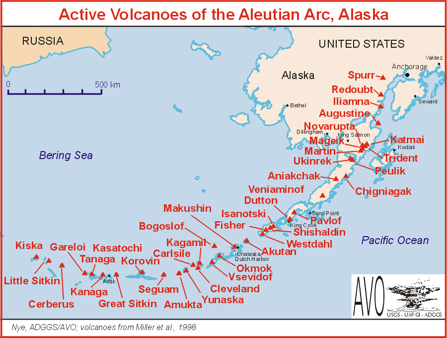
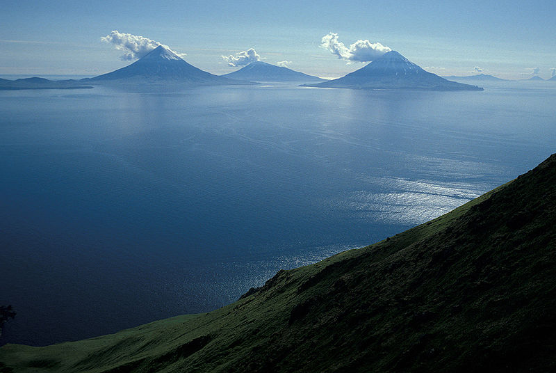
| Aleutian Range, Aleutian Arc |
|
|
|
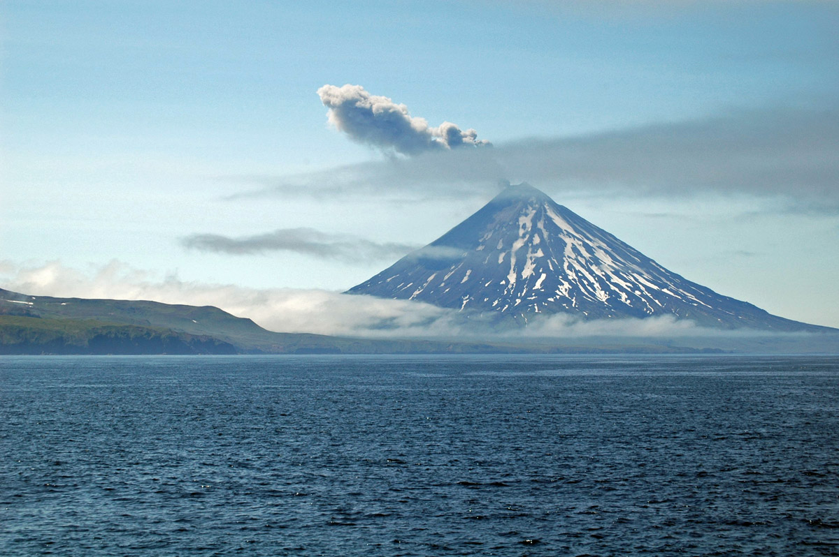
Pavlof |
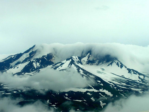
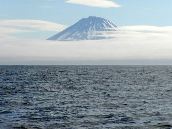
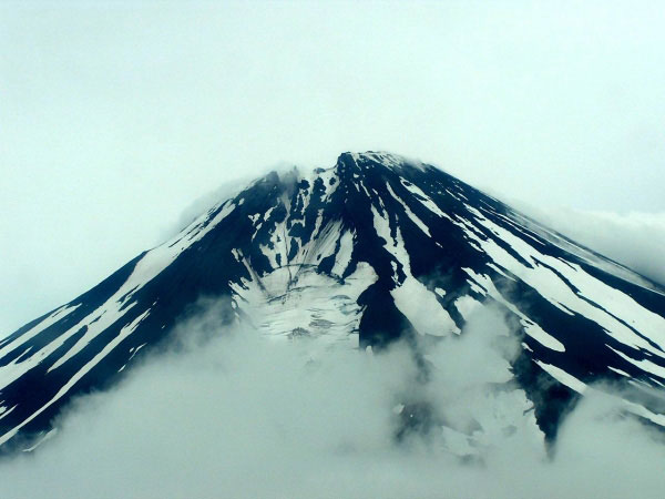
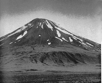
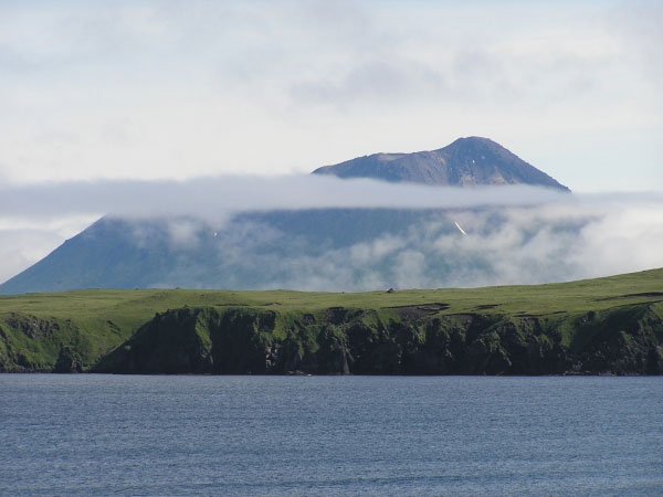
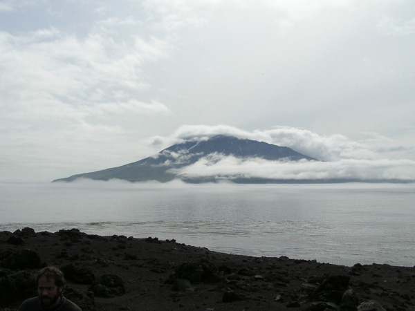
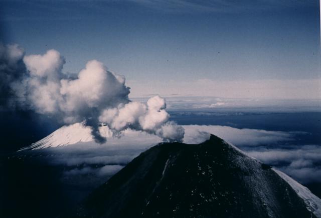
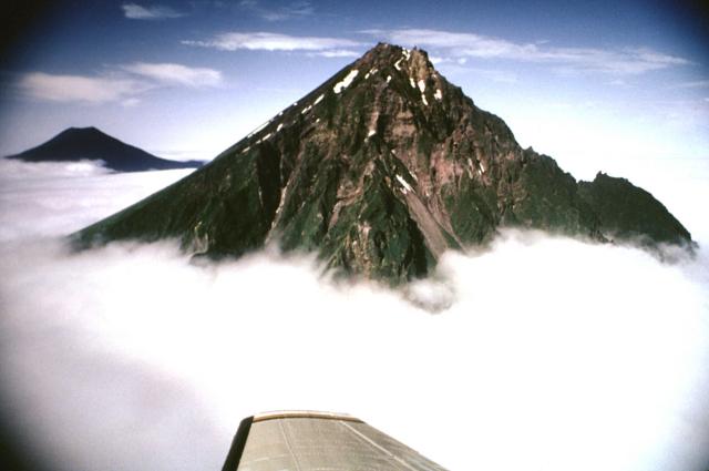
Recheschnoi Volcano with clouds draping part of the summit as seen from a plane. The image was re-exposed in order to decrease the glare and haze in the image From Wood and Kienle (1990): "Mount Recheshnoi is a large, heavily glaciated stratovolcano on central Umnak Island, 10 km east of Mount Vsevidof, its nearest volcanic neighbor. The central part of the cone is built on a flat erosional surface ~60 m above sea level cut on Tertiary plutonic and sedimentary rocks. The east and northeast flanks overlie ~300 m of lava flows from older volcanoes. The central 40-50 square km (above 1000 m elevation) consists of pyroclastic beds and a vent complex. This area has been heavily eroded by 9 small valley glaciers and retains none of its original constructional volcanic form. The summit area consists of a 4-km-long east-west ridge which may reflect construction from an older eastern vent and a younger western vent. Below 1,000 m the volcano consists of andesite flows with minor pyroclastic interbeds. The original construction is preserved in some upland areas between glaciers, especially on the western flank. The central cone is probably mostly Pleistocene in age. A glaciated basaltic parasitic cone exists on the northwest flank. Post-glacial deposits are limited to andesitic cinder cones and flows on the east and west flanks, a series of small rhyolite domes on the west flank and a quartz-olivine andesite dome on the east-northeast flank. There is a large zone of hot springs and a few geysers 8 km northeast of the summit." http://www.avo.alaska.edu/volcanoes/volcinfo.php?volcname=Recheshnoi |
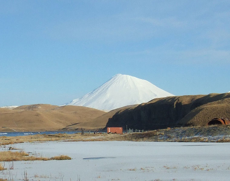
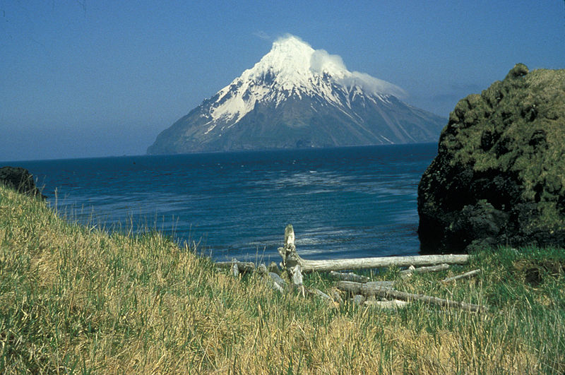
Scenic view of volcanoes Recheshnoi and Vsevidof on southwest Umnak Island. Mount Recheshnoi (also spelled Recheschnoi), 1984 m, is a heavily eroded stratovolcano located near the center of the SW lobe of Umnak Island in the Aleutian Islands of Alaska.The northeast flank of Recheshnoi has one of the hottest and most extensive thermal areas in Alaska. The Geyser Bight geothermal area consists of six zones of thermal springs and two fumarolic areas along upper Geyser Creek and contains the only known geysers in the state. In three locations in 1988 here have been found 5 active geysers up to 2 m high and 9 natural fountains up to 0.7 m high. Other thermal areas occur at Hot Springs Cove and Partov Cove on the isthmus between Recheshnoi and Mount Okmok http://en.wikipedia.org/wiki/Mount_Recheshnoi |
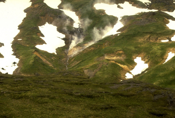
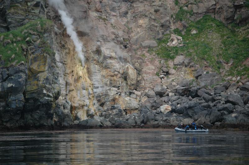
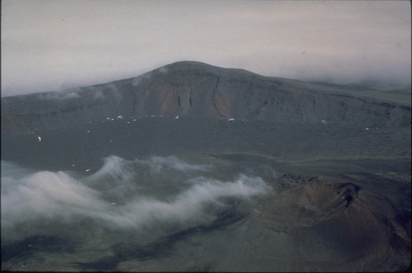
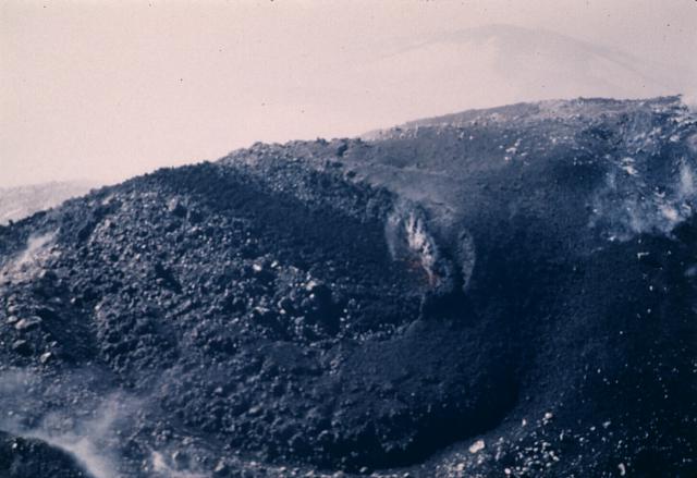
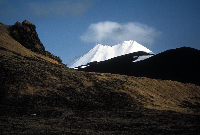
View, looking west, at the head of the Russian Bay valley of Mount Recheshnoi, a deeply dissected, 1,984-m (6,510 ft)-high stratovolcano on central Umnak Island in the eastern Aleutian Islands. Unlike Vsevidof volcano, its neighbor to the west, Recheshnoi volcano has had no documented historical eruptions. Photograph by C. Nye, Alaska Division of Geological and Geophysical Surveys, August, 1985 |
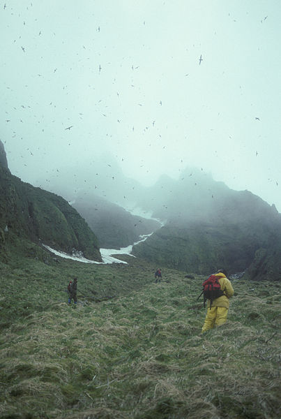
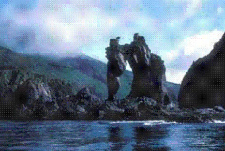
View of an active fumarole near Russian Bay on Mount Recheshnoi, a deeply dissected, 1,984-m (6,510 ft)-high stratovolcano on central Umnak Island in the eastern Aleutian Islands. Photograph by C. Nye, Alaska Division of Geological and Geophysical Surveys, August, 1985.laska has many places with interesting geothermal features but only one has true geysers - Mount Recheshnoi Geyser field on Umnak Island.History.Hot springs in this location were first mentioned in written sources by Baltic geologist of Dutch descent Constantin von Grewingk in 1850. Local Aleuts for sure knew about these geysers much longer.More thorough research took place in 1947, 1980 and 1988.All geysers are located in wide valley at the foot of Mount Recheshnoi volcano. This valley has been formed by glacier and now here flows a stream - Geyser Creek.Geothermal energy is provided by the plume of magma under Mount Recheshnoi. Water below the ground level is superheated - it is considered that the temperature of steam deep under the ground exceeds 265 �C.Hydrothermal features are spread along the Geyser Creek and its tributaries over an area of 4 km2.Geysers are found in three locations: site G, site H and site J .Here are found not just geysers but also natural fountains, boiling (effervescent) springs and mud pools.As it is usual in most geyser fields in the world, as the time goes, the number of active geysers is changing.One characteristic though makes the geysers of Umnak unique - the water of these hot springs contains much boron and arsenic.Site G. In this site in 1947 were reported 1 geyser and 1 fountain. In 1980 here were 4 geysers. In 1988 here was 1 geyser and 6 fountains, which were up to 30 cm high.The geyser in 1988 represented a water filled bowl of sinter. Every 12 minutes it erupted 0.2 m high. Back in 1870 it was 0.6 m tall.Site H. Here in 1947 were 3 geysers, in 1980 - 3 geysers and 1 fountain, in 1988 - 3 geysers and 3 fountains. One of fountains in 1988 was up to 0.7 m tall - this same fountain in 1947 was a geyser, which erupted every 2.5 - 3.5 minutes.One geyser in 1988 was up to 2 m high, another one - 0.5 m high.Site J. Here at a smaller creek have formed serveral geothermal features. In 1947 this location has not been mentioned, in 1980 here was 1 geyser. In 1988 here was found 1 geyser - a small pool, where approximately once per hour were emitted gases and increased water flow.http://www.wondermondo.com/Countries/NA/US/Alaska/RecheshnoiGeyser.htm |
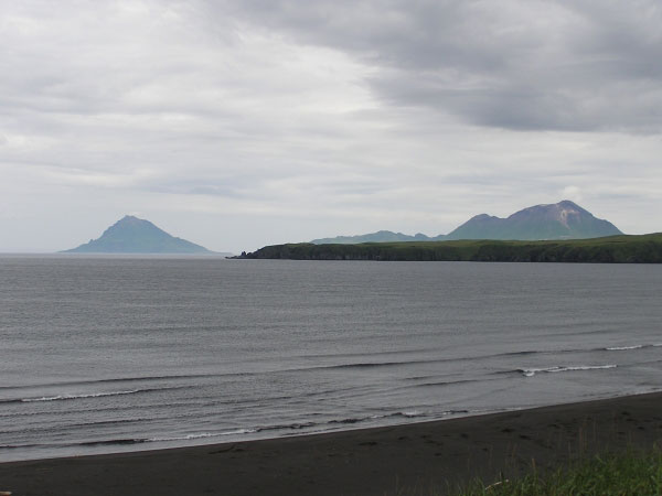
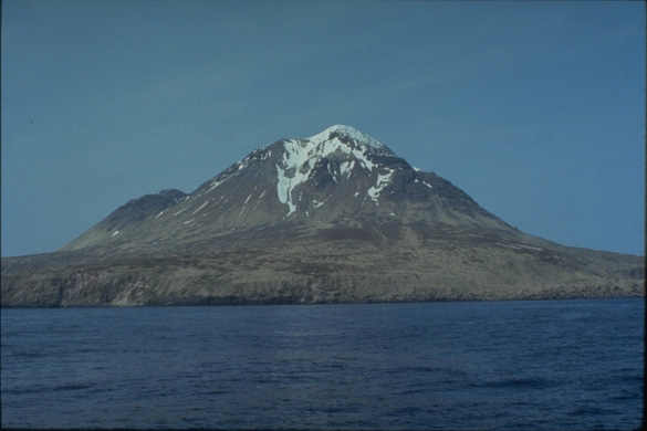
Mount Vsevidofe from Nikolski |
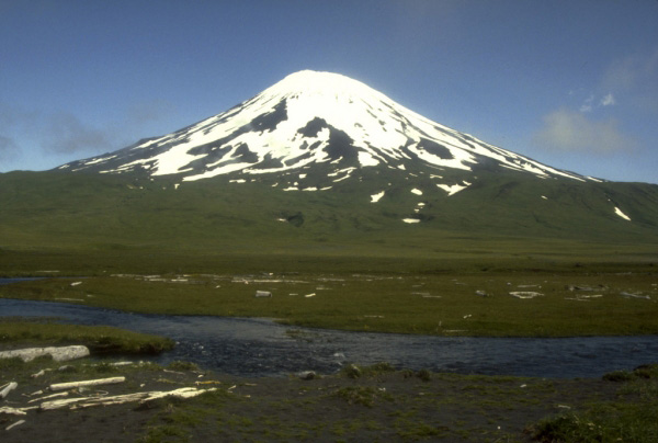
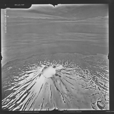
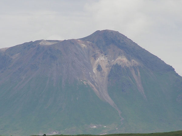
From Miller and others (1998): "Mount Vsevidof is a symmetrical stratovolcano near the southwest end of Umnak Island. It is about 10 km wide at the base and steepens from 15 degrees at 300 m altitude to about 30 degrees near the summit. A circular crater, 1.2 km in diameter, occupies the summit. Glacial ice fills the crater and extends down the north and east flanks of the cone; some of these glacial tongues have incised narrow canyons up to 120 m deep. A chain of small cinder cones (unit Qc) below altitude 1220 m parallels a rift on the western flank (Byers, 1959). Young flows of andesite and dacite (unit Qvf) were extruded from this rift and from other vents on north and south flanks of the cone. Pyroclastic deposits, apparently products of a culminating summit eruption, attain a thickness of more than 30 m at the crater but thin downslope. The oldest Vsevidof flows (unit Qvba), are overlain by till of the last major glaciation, but the bulk of the cone is believed to be of post-glacial, i.e., Holocene, age. The cone is locally underlain by hypersthene-andesite lava flows and pyroclastic rocks of the more deeply eroded Mount Recheschnoi. Lava flows from both Recheschnoi and Vsevidof unconformably overlie a basement of probable early to middle Tertiary age including plutonic rocks (unit Tdp) and altered sedimentary and metamorphic rocks http://www.avo.alaska.edu/volcanoes/volcinfo.php?volcname=Vsevidof |
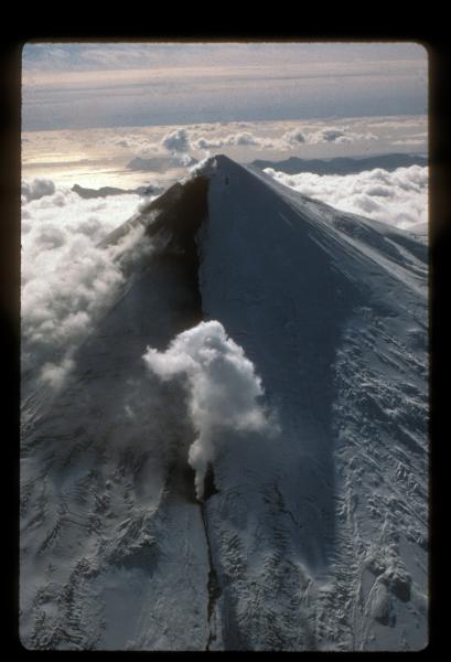
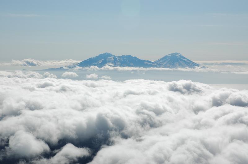
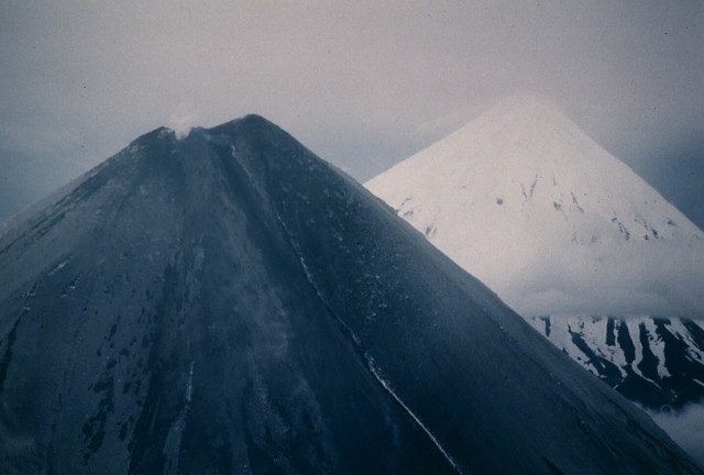
Vsevidof Volcano, 2149 m, with clouds draping part of the summit as seen from a plane. The image was re-exposed in order to decrease the glare and haze in the image. Most Recent Activity: March 11, 1957. |
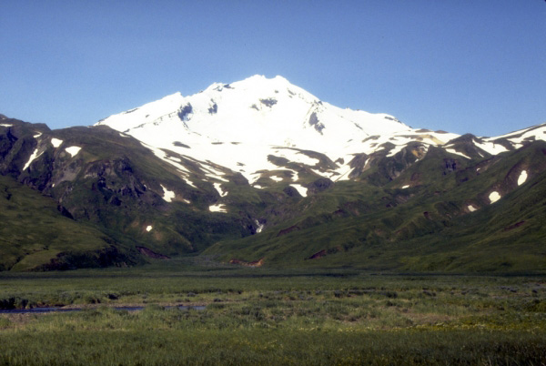
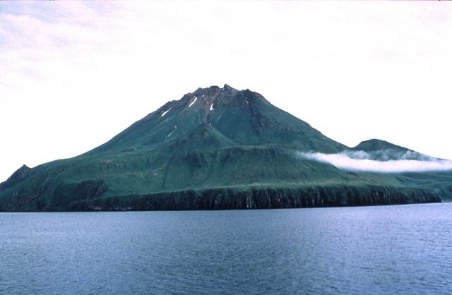
View, looking north, of symmetrical Vsevidof volcano, a historically active, 2,149-mhigh stratovolcano on central Umnak Island in the eastern Aleutian Islands. Photograph by C. Nye, Alaska Division of Geological and Geophysical Surveys, August, 1985 |
Vsevidof from the south. Plate 44 in Kennedy and Byers (1959).- http://volcano.oregonstate.edu/vsevidof-and-recheschnoi-volcanoes |
Vsevidof |
An eroded stratovolcano, 888 m, forms the small, trianglular, 3-km-wide island of Uliaga, located at the NE end of the Islands of Four Mountains archipelago immediately NW of Kagamil Island. Uliaga volcano rises to only 888 m and is the smallest of the "Islands of Four Mountains" volcanoes. Little is known geologically about this volcano, and there are no reports of historical eruptions. The small, triangular, 3-km-wide island of Uliaga, located at the NE end of the Islands of the Four Mountains archipelago immediately NW of Kagamil Island, is composed of a small, eroded stratovolcano. Uliaga volcano rises to only 888 m and is the smallest of the Islands of the Four Mountains volcanoes. There are no reports of historical eruptions from Uliaga, but the volcano was considered to have been active during the Holocene (Nye et al., 1998). Photo by Michelle Harbin (courtesy of U.S. Geological Survey, Alaska Volcano Observatory -http://www.volcano.si.edu/world/volcano.cfm?vnum=1101-25- |
Photo of Uliaga Volcano (left) and Kagamil Volcano (right) as viewed from the western side of Applegate Cove on the northeastern flank of Mt. Cleveland |
Photo of Kagamil Volcano as viewed from the western side of Applegate Cove on the northeastern flank of Mt. Cleveland -http://www.avo.alaska.edu/volcanoes/volcinfo.php?volcname=Kagamil |
Active fumarole on the south shore of Kagamil Island. Additional fumaroles are located along the cliff, and gases percolate through kelp beds in the intertidal zone -http://www.avo.alaska.edu/volcanoes/volcinfo.php?volcname=Kagamil |
Steam is visible from the coastal fumarolic area on the southern flank of Kagamil Volcano. A section of older layered lava flows is also visible at the coast-.http://www.avo.alaska.edu/volcanoes/volcinfo.php?volcname=Kagamil |
Zoomed in photo of the southwest summit region of Kagamil Volcano as viewed from the western side of Applegate Cove on the northeastern flank of Mt. Cleveland. An undated lava flow can be seen on the right side (southeast side) of the summit.From Miller and others (1998): "Kagamil volcano occupies most of the southern half of Kagamil Island, 55 km west of Umnak Island in the eastern Aleutian arc. The volcano consists of two cones and has an oval shape, 3.5 by 2 km in basal dimensions, with the long axis trending northwest-southeast. The larger cone at the southeastern end of the volcano has an elevation of 893 m; the cone at the northwestern end is about 610 m high and appears to have two small summit craters. Hot springs and fumaroles occur near the southeastern shore of the island (Sekora, 1973). "Both cones appear to be virtually undissected by erosion, indicating a post-glacial age. The cones rise from a more gently sloping surface with mean elevation of about 200 m." http://www.avo.alaska.edu/volcanoes/volcinfo.php?volcname=Kagamil |
http://www.avo.alaska.edu/volcanoes/volcinfo.php?volcname=Kagamil |
http://www.eosnap.com/tag/alaska/ |
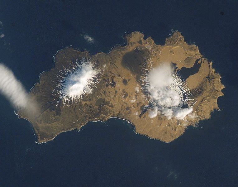
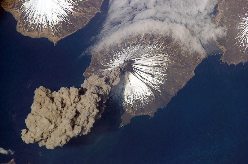
The Islands of Four Mountains, centered on Mount Cleveland. Dark lines are ash flows.- http://en.wikipedia.org/wiki/Mount_Cleveland_(Alaska) |
Yunaska is the largest of the Islands of Four Mountains group in the Aleutian Islands of southwestern Alaska, United States. It has a land area of 173.099 km2.The island measures 19.5 km long and 18.6 km wide.The island comprises two volcanic mountains, with a valley between. The western mountain is composed of four overlapping and eroded stratovolcanoes, with a cinder cone field at the western end. It has not been historically active. The eastern mountain is a large shield volcano with two overlapping summit calderas, which last erupted in 1937- http://en.wikipedia.org/wiki/Yunaska_Island. |
Aerial view of young lava flows within the Caldera of Herbert Volcano. From Wood and Kienle (1990): "Herbert is a classic stratovolcano with a 2.1-km-wide caldera, which the topographic map indicates is breached to the northwest. Radar images do not show the breach. No geologic studies have been published on this volcano. A grab sample from the tip of the island''s southwest point is an andesite (59% SiO2, with 0.82% K2O)."- http://www.avo.alaska.edu/volcanoes/volcinfo.php?volcname=Herbert |
Photo of the best view of Mt. Herbert volcano as observed from the 2003 campsite on the volcaniclastic debris flow fan deposit created from the 2001 Mt. Cleveland eruption. The volcano was usually obscured by clouds during the 2003 fieldwork Herbert Island is an island in the Islands of Four Mountains subgroup, 10.0 km across, Herbert Island is somewhat circular in shape and is covered by the 1,300 m Herbert Volcano, whose two km wide caldera is one of the largest in the Aleutian Islands - http://www.avo.alaska.edu/volcanoes/volcinfo.php?volcname=Herbert |
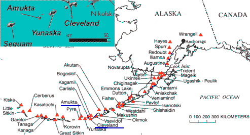
Islands of Four Mountains is an island grouping of the Aleutian Islands in Alaska, United States. The chain includes, from west to east, Amukta, Chagulak, Yunaska, Herbert, Carlisle, Chuginadak, Uliaga, and Kagamil Islands. This island chain is located between Amukta Pass and the Andreanof Islands to the west, and Samalga Pass and the Fox Islands to the east. These islands have a total land area of 545.596 km2. The two largest islands are Yunaska and Chuginadak. Chuginadak is mainly made up of the active volcano Mount Cleveland.The name is translated from Russian ��������������� ������� and was applied by the early Russian explorers because of four prominent volcanoes located on four of the islands. http://en.wikipedia.org/wiki/Islands_of_Four_Mountains |
Mount Cleveland, Alaska.The beautifully symmetrical Mount Cleveland forms the western half of Chuginadak Island. The 1730-m stratovolcano is one of the most active volcanoes of the Aleutian Islands. This July 24, 1994, view from the west shows the summit region darkened by ashfall that may have originated from an eruption reported on May 25. Dark lava flows from earlier eruptions can be seen on the flanks of the volcano,Mount Cleveland is a nearly symmetrical stratovolcano on the western end of Chuginadak Island, which is part of the Islands of Four Mountains just west of Umnak Island in the Fox Islands of the Aleutian Islands of Alaska. Mt. Cleveland is 1,730 m high, and one of the most active of the 75 or more volcanoes in the larger Aleutian Arc. Aleutian natives named the island after their fire goddess, Chuginadak, who they believed inhabited the volcano. In 1894 a team from the U.S. Coast and Geodetic Survey visited the island and gave Mount Cleveland its current name, after then-president Grover Cleveland.One of the most active volcanoes in the Aleutian Arc, Cleveland has erupted at least 21 times in the last 230 years. A VEI 3 eruption in 1944 produced the arc''s only direct volcanic fatality. Most recently Mount Cleveland has erupted three times in 2009, twice in 2010, and once in 2011. The volcano''s remoteness limits opportunities for its study, and the Alaska Volcano Observatory relies heavily on satellites for monitoring. The volcano is primarily hazardous to aircraft; many of the flights over the north Pacific approach the vicinity of the volcano, and volcanic ash released from eruptions can damage sensitive electronic equipment and sensors Mount Cleveland is located 490 km from the western end of the Aleutian Arc, a long volcanic chain extending off the coast of Alaska. Containing over 75 volcanoes, this volcanic arc occurs above the subduction zone where the Pacific Plate plunges under the North American plate. As the plate moves deeper into the earth, the increasing pressure results in the loss of volatiles, certain elements and compounds with low boiling points, from various hydrous minerals. One of these compounds is water; its addition to the mantle wedge formed between the subducting and overriding plates lowers the melting point enough to allow magma to form. The melted material then rises to the surface and forms a volcano�in this case, the Aleutian Arc. Mount Cleveland is an almost symmetrical andesite stratovolcano in the Islands of Four Mountains, a volcanic group in the Aleutian Arc. Like all stratovolcanoes, Mount Cleveland grew as explosive eruptions, effusive eruptions, and lahars built it layer by layer into a concave-up shape. It lies southeast of Mount Carlisle and northeast of Herbert Island. Mount Cleveland forms the western half of Chuginadak Island, a broad and uneven bell-shaped landmass, and is the highest of the four volcanic islands. The island is completely uninhabited; the nearest settlement is Nikolski on Umnak Island, about 75 km (47 mi) eastward. Mount Cleveland is 8�8.5 km wide at its base[ and roughly 29 km3 in volume. The volcano''s slope increases markedly with height, from 19� at its lower flanks to 35� near its summit. Like many other Aleutian volcanoes, Cleveland''s flanks are especially rough up to 300 m, covered by multiple overlapping lava flows and debris fans that form an apron around the mountain. Lava flows are always built on top of debris flows as a result of the snow melt caused by the emission of heat just before an eruption. The flows are generally short, under 1 km (0.6 mi), and thin, less than 10 m thick, and are somewhat vegetated. Although Mount Cleveland is the tallest mountain in the group, it is rarely completely snowed in because of its constant activity disrupts snowfall. A lack of extant erosion shows that Mount Cleveland is likely a Holocene volcano, forming within the last 10,000 years. All known events have occurred at Mount Cleveland''s summit vent, but there are at least five small andesite to dacite volcanic domes on the lower flanks. The volcano has no caldera.[The eastern half of Chuginadak, to which Mount Cleveland is connected by a narrow isthmus, consists of several low-lying volcanic cones and two prominent peaks that have been heavily eroded, partly by glaciers. Known as the Tana volcanic complex, the two features measure 1,170 m and 1,093 m in elevation. A sample of rhyolite has been recovered from Concord Point, the easternmost point on the island. http://en.wikipedia.org/wiki/Mount_Cleveland_(Alaska) |
Ash plume arising from Mount Cleveland on May 23, 2006, as seen from the International Space Station. Astronauts were the first to observe the eruption, and alerted the Alaska Volcano Observatory.[Mount Cleveland erupts in 2006. Taken from the International Space Station- http://en.wikipedia.org/wiki/Chuginadak_Island. Eruptions from Mount Cleveland are generally vulcanian and strombolian in nature, characterized by short explosive ash clouds sometimes accompanied by a''a flows, lava fountains, pyroclastic flows, ash and steam emissions, lava dome growth, and the ejection of breadcrust bombs. Hot springs were reportedly found on the volcano in the 1800s, and persistent fumarolic activity was observed in the 1980s and 1990s. Mount Cleveland is a site of persistent steam emissions and thermal anomalies that represent constant background activity. Little is known about Cleveland''s early eruptive history as its remoteness makes it a difficult area to investigate, and discrepancies in names have caused confusion between events there and those on nearby Carlisle. Even today, not all possible events are confirmed as eruptions by the Alaska Volcano Observatory, and many are listed as "possible." In observed history, Mount Cleveland may have first erupted in 1744; the first confirmed eruption occurred in 1828. The volcano erupted again in 1836 (possibly), 1893, 1897 (possibly), 1929 (possibly), 1932, and 1938 (possibly).[The first notable eruption from Mount Cleveland was a Volcanic Explosivity Index (VEI) 3 Vulcanian eruption that occurred between June 10 and June 13, 1944. Lava flows extended 5 kilometers (3 mi) from the summit, and an ash plume 6,000 m high was produced. Large boulders were reportedly ejected and carried out to sea by eruptive force. The eruption had the distinction of being the only confirmed direct volcanic fatality in Alaska; a small detachment from the Eleventh Air Force was stationed on the volcano at the time, and one Sergeant Purchase left his post early in the eruption to take a walk and never returned, probably killed by mudslides. At approximately 10:20, a boat sent to search for Purchase witnessed the end of the eruption. The island was abandoned for the remainder of the war.Mount Cleveland erupted more recently in 1951, 1953, 1954 (possibly), 1975 (possibly), 1984 through 1987, 1989, 1994, and 1997. The volcano has received more focused attention in recent times due to its increased activity: it erupted in 2001, 2005, three times in 2006, 2007, three times in 2009, and twice in 2010. Of these, the most significant eruption was the 2001 eruption, which produced a 12 km (7 mi) high ash plume. This plume dispersed 120 to 150 km across Alaska, an unusual distance that allowed detailed satellite observations to be made. Nikolski and the surrounding region was the site of several hours of ashfall, represented in satellite imagery as areas of discolored snow. This eruption significantly disrupted air traffic in the area. The volcano has erupted at least 21 times in the last 230 years. The biggest threat posed by an eruption from Mount Cleveland is its ash plume, which can damage sensitive electronic equipment on overflying planes. http://en.wikipedia.org/wiki/Mount_Cleveland_(Alaska) |
A steam plume rises above the summit crater of Cleveland volcano on June 23, 1987. The upper flanks of the volcano are darkened by ashfall from an explosive eruption that began on June 19. The steaming summit vent began producing a lava flow on June 23 that eventually descended 2.5 km down the ESE flank. Lava fountaining was observed on July 22. A large explosive eruption took place on August 28, the last day of the eruption. This view from the ENE show part of Herbert volcano behind the plume at the left.Photo by Harold Wilson, 1987 (Peninsula Airways), courtesy of John Reeder (Alaska Div. Geology Geophysical Surveys).-http://www.volcano.si.edu/world/volcano.cfm?vnum=1101-24-&volpage=photos |
Steam emissions from the summit of Mount Cleveland, 15 August 2008 |
Clevelend. An eruption in 1987 began with explosive activity on June 19 that deposited ash over fresh snow on all sides of the volcano. On June 23, the date of this photo, a lava flow from the summit was observed that eventually extended 2.5 km down the ESE flank. Lava fountaining was observed on July 22, and on August 28 a large explosive eruption produced an eruption column that reached over 10 km altitude. Photo by Harold Wilson (Peninsula Airways), 1987, courtesy of John Reeder (Alaska Div. Geology & Geophysical Surveys).http://www.volcano.si.edu/world/volcano.cfm?vnum=1101-24-&volpage=photos |
An aerial view of two symmetrical Aleutian volcanoes shows the effect of volcanic ashfall. Both Cleveland (left) and Carlisle (right) volcanoes are snow-covered, but the flanks of Cleveland volcano in this June 24, 1987, view from the ESE are darkened by deposits of ash from an explosive eruption that began on June 19.Photo by Harold Wilson, 1987 (Peninsula Airways), courtesy of John Reeder (Alaska Div. Geology Geophysical Surveys) - http://www.volcano.si.edu/world/volcano.cfm?vnum=1101-24-&volpage=photos.Carlisle Island has as diameter of 6.9 km and is dominated by the 51,610 m conical stratovolcano of the same name. Mount Carlisle, 1,620 m, is a stratovolcano in Alaska which forms part of the 8 km wide Carlisle Island, one of the Islands of Four Mountains which, in turn, form part of the central Aleutian Islands. Despite its modest summit elevation, a small glacier exists high on the western slopes just below the rim of the summit crater.A few historical eruptions of Carlisle have been recorded, but its proximity to several other neighboring volcanoes means that there has been some confusion in the older records as to which of the volcanoes was erupting. As the area is extremely remote, distant observations of volcanic plumes cannot be verified for certain.Last eruption November 16, 1987. |
Amukta is a small yet mountainous island in the Islands of Four Mountains group lying between the Fox Islands and the Andreanof Islands in the Aleutian Islands. The nearest islands to it are Yunaska and Seguam Island; it is separated from Seguam Island by Amukta Pass. The small island of Chagulak lies directly northeast of it. The island reaches a total height of 1,055 m. The island measures 9 kilometres long and 8.3 km wide - http://en.wikipedia.org/wiki/Amukta_IslandThe undissected stratovolcano , 1066 mof Amukta volcano makes up most of nearly circular, 7.7-km-wide Amukta Island. It is the westernmost of the Islands of Four Mountains chain. The cone, about 5.8 km in basal diameter and topped by a 0.4 km wide summit crater, appears on synthetic-aperture radar imagery to be built upon a 300+ meter high, east-west trending arcuate ridge. Extensions of that ridge on the southwest and east sides of the island indicate an older caldera approximately 6 km in diameter and open to the sea on the south side. No hot springs or fumaroles have been reported from Amukta. Sekora (1973, p. 29) reports the presence of a cinder cone near the northeastern shore of the island.Well documented reports of historical Amukta volcanism are sparse; activity was noted from 1786 to 1791, and again in 1876 (Coats, 1950). Petroff (1884, citing Grewingk, 1850) lists activity at Amukhton in 1770, presumably the same volcano; conversely, Dall (1870, citing Grewingk, 1850) describes a cessation of activity at Amukta in 1770. On February 13, 1963 an eruption occurred involving the central crater and one or more parasitic vents; both ash and lava were produced (Anchorage Times, February 11, 1963; Decker, 1967). Persistent low clouds obscured the exact source of the lava, but the flow was seen to extend from the west side of the cone southwest into the sea at Traders Cove (Bulletin of Volcanic Eruptions, 1963).In late August and early September, 1987, a commercial pilot observed a 10.5 km high eruption plume rising through cloud cover near Amukta Island. On September 4, another pilot observed a small dark ash plume issuing from the summit of Amukta (Smithsonian Institution, 1987). On Sept. 18, yet another pilot reported a 300m-high ash plume. In early July 1996, a passing ship reported a 1-km high plume of "ash and smoke" (Neal and McGimsey, 1997). On August 28 Mt. Cleveland, 100 km to the northeast, was also active and winds were blowing towards Amukta. Igneous rocks produced by this volcano range from Granite to Monzonite, however the most common rock found in/around Mt. Amukta is Basalt. http://en.wikipedia.org/wiki/Mount_Amukta |
The 3-km-wide island of Chagulak in the Islands of the Four Mountains group is the summit of a small, unstudied stratovolcano NE of Amukta volcano. The two volcanoes coalesce at depth although they are separated by 7 km of ocean. Yunaska volcano lies about 20 km to the east. Sharp-topped Chagulak volcano rises steeply to 1142 m and is ruggedly dissected on the east side. No historical eruptions have been recorded from Chagulak volcano, and its age is not precisely known.- http://www.volcano.si.edu/world/volcano.cfm?vnum=1101-20-&volpage=photos&photo=095085 |
Chagulak Island, seen from Amukta Island. Chagulak Island is a small, uninhabited volcanic island in the Islands of Four Mountains group in the Aleutian Islands of southwestern Alaska, United States. The 3.1 km-wide island consists of a single cone that reaches an elevation of 1,142 m. Chagulak is a stratovolcano and is separated from the nearby Amukta Island by a channel about6.9 km wide; though the two islands are joined underwater. No eruptions have been recorded and very little is known about the volcano - http://en.wikipedia.org/wiki/Chagulak_Island |
Chagulak Island -http://en.wikipedia.org/wiki/Chagulak_Island |
Chagulak Island |
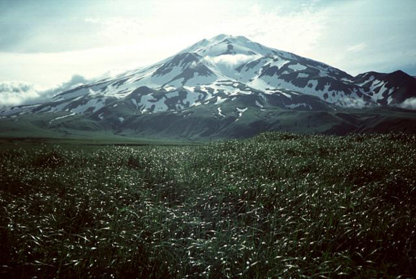
The snow-dappled slopes of Pyre Peak are seen from near the western tip of Seguam Island. The elliptical, 11.5 x 24 km island contains two calderas, each with a Holocene central volcano. A third Holocene cone lies at the eastern end of the island. Pyre Peak was constructed within the 3-km-wide westernmost caldera. The 1054-m-high cone rises 1 km above the caldera floor and has been the source of most of the historical eruptions of Seguam volcano. The elliptical, 11.5 x 24 km island of Seguam, lying between Amlia and Amukta Islands in the central Aleutians, contains two calderas with Holocene post-caldera cones. Growth of the basaltic-to-rhyolitic Wilcox volcano on the east side of the island during the late Pleistocene was followed by edifice collapse and an associated ignimbrite eruption about 9000 years ago, leaving a horseshoe-shaped caldera open to the west, inside which a rhyolitic cone was constructed. The 3 x 4 km wide westernmost caldera has a central scoria cone, Pyre Peak, which rises above the caldera rim and is the source of most of the historical eruptions of Seguam volcano.A very young basaltic field surrounds Pyre Peak, and lava flows partially fill the caldera and reach the southern coast. Older Holocene lava flows were erupted from vents within the eastern caldera, and a monogenetic Holocene cone forms Moundhill volcano on the eastern tip of the island. PHOTO SOURCE:Photo by Steve Ebbert, 1996 (U.S. Fish and Wildlife Service) - http://www.geographic.org/photos/volcanoes/volcano_photos_261.html. |
Seguam Island is a small volcanic island in the Andreanof Islands group in the Aleutian Islands of Alaska. The island is mountainous and oval shaped with a land area of 207.3 km2. It is 26 km long and 10.9 km wide. The island consists of several overlapping stratovolcanoes, and it contains two calderas each with central volcanic cones. About 10 historical eruptions have been recorded since the late 18th century, the most recent in 1993. All recent activity has occurred at Pyre Peak, the cone within the western caldera and the highest point on the island, and has produced explosive eruptions and basaltic lava flows - http://en.wikipedia.org/wiki/Seguam_Island |
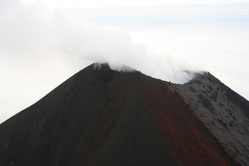
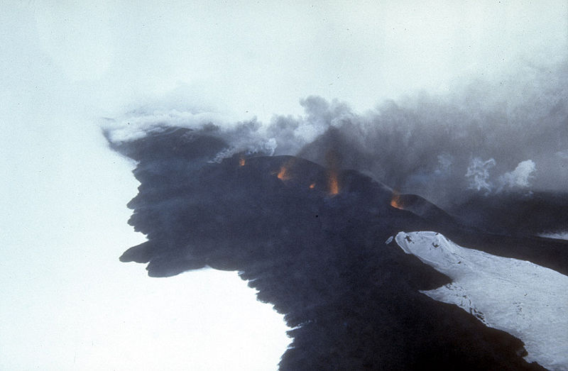
Incandescent lava fountaining from a fissure eruption near Pyre Peak on Seguam Island, 1054 m, last eruption 1993, stratovolcano - http://en.wikipedia.org/wiki/Mount_Seguam |
Seguam lava |
http://www.pelagicodyssey.ca/styled-3/styled-4/ |
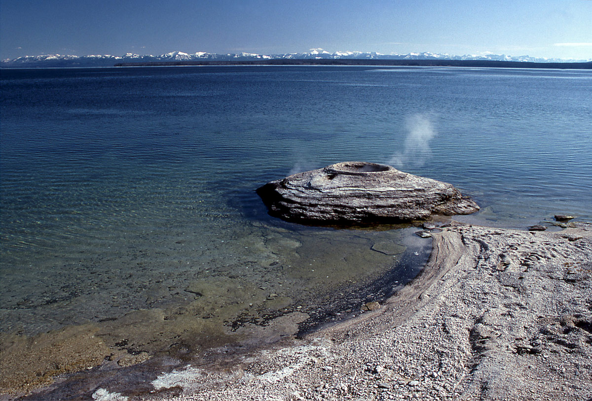
Fishing cone geyser, Wyoming, United States.-http://www.wondermondo.com/Attractions/Geysers.htm |
|