 | Central aleutian Islands, Aleutian Arc |
Undersea volcanoes -http://www.sfos.uaf.edu/news/2003/0811volcano.html |
|
|
http://www.avo.alaska.edu/images/image.php?id=10002 |
Atka |
Japanese occupation of the Aleutians, and the Tule Segregation center - http://en.wikipedia.org/wiki/Atka_Island |
Topographic map of Atka Island, including Korovin, Kliuchef, Konia, and Sarichef. - http://www.avo.alaska.edu/images/image.php?id=664 |
Geologic map of Atka volcano, including Korovin, Sarichef, and Kliuchef - http://www.avo.alaska.edu/images/image.php?id=528 |
Atka Island from Amlia Island. Aleutian Islands, Alaska 52.38 N, 174.15 W summit elevation 1530 m stratovolcanoes . Atka volcano is located in the central Aleutian Islands, Alaska. It consists of a large shield volcano capped by small andesitic and dacitic vents. Northeastern Atka is formed of young volcanic rocks which have been transformed into rugged terrain by a combination of volcanic and glacial activity. This part of the island covers 360 km2 and an eruptive volume of 200 km3.The oldest eruption products are a series of basaltic andesite to dacite flows, pyroclastic rocks and lahars found around the edge of Korovin Bay. A caldera-forming eruption occurred 300 to 500 KA. After caldera collapse, four major volcanic cones grew around the edge of Atka caldera: Korovin, Kliuchef, Konia and Sarichef. late November satellite images showed ash on the E flank of the main crater. On 21st December 2006, small amounts of ash were emitted. 2005 EruptionOn 23rd February 2005, a small ash emission occurred from Korovin. Ash emissions reached an altitude of 2.4 km and was followed by several smaller ash emissions. 1998 Eruption On 30th June 1998 an eruption plume reached 9 km above sea level.1986 Eruption On 23 May 1986 a steam eruption occurred at Atka Volcano 15 days after a magnitude 7.7 earthquake 100 km away. Eruptions 2006, 2005, 1998, 1996, 1998, 1995, 1987, 1986, 1812 -http://www.volcanolive.com/atka.html |
The 200 km3 Atka volcano, 1533m, caldera, is the largest volcanic center in the central Aleutians. A central shield volcano and caldera is ringed by 7 or 8 satellitic volcanoes.This view, from near Atka village, shows 1533-m-high Korovin volcano, the highest and northernmost of three Holocene stratovolcanoes of the Atka volcanic complex.Korovin has been the most active during historical time, but Sarichef and Kliuchef volcanoes may also have had historical eruptions. Photo by James Dickson, 1986 (courtesy of John Reeder, Alaska Div. Geology Geophysical Surveys).The largest volcanic center in the central Aleutians, Atka consists of a central shield and Pleistocene caldera ringed by 7 or 8 satellitic volcanoes. The most prominent of these are the post-caldera cones of Korovin, Konia, Kliuchev, and Sarichef, some of which have been active in historical time. Korovin, the most frequently active volcano of the Atka volcanic center, contains a 1533-m-high double summit with two craters located along a NW-SE line. The NW summit has a small crater, but the 1-km-wide crater of the SE cone has an unusual, open cylindrical vent of widely variable depth that periodically contains a crater lake or a high magma column (Marsh; in Wood and Kienle, 1990). A fresh-looking cinder cone lies on the flank of partially dissected Konia volcano. Sarichef has a symmetrical profile, and Korovin and Kliuchef are relatively uneroded and the source of most if not all historical eruptions. Hot springs and fumaroles are located on the flanks of Mount Kliuchef and in a glacial valley SW of K http://volcano.oregonstate.edu/atka |
Panorama of thermal area west of Korovin volcano. Informally known as Old Steamy -http://www.avo.alaska.edu/images/image.php?id=12499 |
Korovin Volcano, Atka Island. Photo by Jennifer Reynolds (UAF SFOS). |
Summit of Korovin Volcano during its eruption of July 2004.Korovin Volcano, 1,533 m, stratovolcano, last eruption 2006, is the highest point on Atka Island, in the Aleutian Islands chain, Alaska, USA. Korovin is a side vent to the main Atka shield volcano -http://en.wikipedia.org/wiki/Korovin_Volcano |
Debris mantling the upper slopes of Korovin''s active south crater. View is to the south-southwest |
Steam rising off of the roiling lake in the bottom of the south crater of Korovin. Although the walls are plastered with tephra, recent, rigorous phreatic activity has stripped the lower walls to bare rock, Korovin volcano - more images - http://www.avo.alaska.edu/volcanoes/volcimage.php?volcname=Korovin |
Close-up view down into the roiling pool that occupies the summit crater of Korovin volcano. Rivlets of ash can be seen that have run back down into the bare rock margin around the pool |
Curd texture of tephra on snow located on the upper east flank of Korovin |
Tephra and debris on the upper east flank of the south crater of Korovin. View is looking down slope |
Satellite vent on northeast flank of Kluichef volcano -http://www.avo.alaska.edu/volcanoes/volcinfo.php?volcname=Atka Kliuchef Volcano is part of the central Aleutian Atka volcanic center, a cluster of stratovolcanoes of which the most active, Korovin, has erupted perhaps as many as nine times since the early 1800''s (Motyka and others, 1993; McGimsey and Miller, 1995). The only historical eruptive activity attributed to Kliuchef occurred in 1812. Atka village is located about 13 km southwest of Kliuchef |
Summit crater of Kluichef. Crater supports a small body of water that was only partially iced-over on this day. Korovin in far distance, and Konia in middle ground |
Largest of a cluster of small fumaroles located on the southern flanks of Kluichef (see image #12442 for location). |
View of Korovin Volcano from the summit of Kliuchef Volcano, both on Atka Island. Konia is the small cone in the saddle. Geologist Bruce Marsh is in the foreground -http://www.avo.alaska.edu/images/image.php?id=628 Kliuchef is the second highest peak 1450 m) and is located at the center of the Atka volcanic field. It is ringed by a series of peaks with heights from 748 m to 1433 m. The peak has a double summit with two small lakes. The summit has been modified by glacial ice, and the lower southeastern flank is partly covered by an ice field. There are three hot springs and fumerolic areas occur on the southern and western flanks. Lavas from Mount Kliuchef contain from 0.4 to 4% clinopyroxene, 0�7.2% olivine, 21.6�36.4% plagioclase, and 0 to 0.6% oxides - http://www.volcanolive.com/atka.html. From Wood and Kienle (1990): "Atka is the largest (~200 cubic km) volcanic center in the central Aleutians. There are no larger centers westward, and the closest larger center is Umnak, some 300 km east. Seguam lies directly to the east, and Great Sitkin to the west. The overall structure of the center is that of a broad central shield which once supported a large (~2,200 m) center cone (Atka volcano) ringed by as many as 7 or 8 smaller satellite volcanoes. The central cone was lost to caldera formation, shutting down the whole system, and the satellite vents still remain at various stages of erosional decay. Sarichef is perhaps the youngest satellite vent and has survived erosion largely unscathed. More often, summit ice buildup has breached the crater walls, forming active cirques, which have deeply incised the satellite vents. Tangential to these vents are U-shaped valleys, formed by moving ice. "Kliuchef volcano grew on the north rim of the now ice-filled Atka caldera and formed a series of five vents striking northeast. The two main summit vents and the easternmost vent are fresh; the latter is most likely the source of the 1812 eruption attributed to Sarichef. Double-coned Korovin volcano next appeared, although overlapping considerably in time with Kliuchef. Six km north of Kliuchef, Konia volcano occupies the middle ground between Korovin and Kliuchef and is as old as much of Korovin itself. Korovin has been and remains the principal active volcano on Atka. It is unusual in that its summit crater marks an open, cylindrical vent reaching nearly to sea level; it has been observed by pilots flying over to sometimes contain a crater lake and at other times to be brimming with magma. This vent is the source of most recent eruptions. "All the volcanoes consist principally of crystal-rich, thin, (<~3m) basaltic lavas with interbedded scoria yielding increasing amounts of pyroclastic debris, autobreccias, and lahars. The summit of Kliuchef is mostly glassy dacite as are some late flows of Korovin and Konia. A thick (~400 m) pink dacite with pumiceous and glassy cooling units was erupted upon formation of Atka caldera, but no ash flows have been found. Thick, expansive lahar aprons fill many early Pleistocene glacial valleys. These have been cut by parse dikes spanning the volcanic center, whose emplacement apparently attended caldera collapse. The lavas themselves are overwhelmingly (>or= 90% by volume) high-alumina basalt, strikingly free of xenoliths. The basalt contains plagioclase, orthopyroxene, magnetite, and clinopyroxene. The andesite and dacite contain orthopyroxene at the expense of olivine; trace amounts of biotite are also found in the dacite. No hydrous phases are found in any basalt or andesite lava. Three hot spring areas are found apparently associated with Kliuchef and Atka caldera, and a fourth spring occurs some 7.5 km west of Kliuchef."http://www.avo.alaska.edu/volcanoes/volcinfo.php?volcname=Atka |
Red Pool hot spring located west of Mt. Kliuchef -http://www.avo.alaska.edu/images/image.php?id=12483 |
Red Pool hot spring located west of Mt. Kliuchef.- http://www.avo.alaska.edu/images/image.php?id=12484 |
One of the several large, active thermal pools located southwest of Korovin and west-northwest of Kluichef on northern Atka Island. This one known informally as Red Pool. Coordinates: 52 20.878'' N 174 14.767'' W - http://www.avo.alaska.edu/images/image.php?id=12447 |
Atka Island hot springs near Korovin and Kliuchef volcanoes - http://www.avo.alaska.edu/images/image.php?id=12298 |
Atka Island hot springs near Korovin and Kliuchef volcanoes -http://www.avo.alaska.edu/images/image.php?id=12295 |
Fumarole fields near Korovin and Kliuchef volcanoes, Atka Island -http://www.avo.alaska.edu/images/image.php?id=12291 |
One of several thermal areas located west of Korovin and Kluichef on northern Atka Island. This particular one is informally called Old Steamy by the geologist who recently worked on the island |
Area on the west shoulder of Konia where numerous small vents are emitting steam and possibly gas. Note steam to the right of helicopter tail.Konia is a small post-caldera cone, situated in a saddle between Korovin and Kliuchef. A fresh cinder cone is located on the western flank |
Several of the numerous small vents on Konia that were emitting steam and possibly gas |
Snow Bank thermal area located on southwest flank of Kluichef. Note steam rising from area in lower left of frame |
Main thermal areas around Korovin, Konia, and Kluichef volcanoes of north Atka Island. Names are informal; numbers are in reference to images in the AVO image data base. A larger version of this (in Powerpoint) is posted in the Logs (12_15_06).http://www.avo.alaska.edu/images/image.php?id=12511 |
Panorama of Sarichef volcano. Sarichef is the volcano furthest in view - http://www.avo.alaska.edu/images/image.php?id=12506 |
Sarichef is located on the eastern edge of the island and formed on the flanks of the ancestral Atka Volcano. |
AVHRR image showing split window signal for ash plume from Kasatochi-http://www.avo.alaska.edu/volcanoes/volcimage.php?volcname=Kasatochi |
Kasatochi volcano is an active stratovolcano and one of the Andreanof Islands subgroup.Kasatochi Island has a land area of 5.051 km2 and is unpopulated.The summit is truncated by a large volcanic crater containing 0.8 km wide crater lake, which was formed after a large, explosive eruption perhaps only a few hundred years ago. The surface of the saltwater lake is less than 60 m above sea level. Recent pictures of the volcano show that the crater lake is still present after the 2008 eruption.On August 7, 2008, Kasatochi began erupting explosively with an ash plume maintaining an altitude of 15 km. As the eruption became imminent, it forced two biologists from the U.S. Fish and Wildlife Service to evacuate the island. An ashfall advisory was issued at the time for Adak Island. Prior to 2008, the last confirmed activity at Kasatochi was in 1899, but that was not believed to be an eruption. Mild degassing was reported to the AVO in 2005, but that could not be confirmed.Currently, there are no seismographs or web cameras on the island of Kasatochi, so scientists must rely on data from nearby Great Sitkin volcano and Adak Island (near Mount Adagdak) to obtain ongoing information on Kasatochi."Fortunately, the existing seismic networks on nearby volcanoes picked up the activity at Kasatochi volcano," said Tom Murray, scientist-in-charge of the Alaska Volcano Observatory (AVO). "They were installed with funding from the Federal Aviation Administration to reduce the hazard to aviation from volcanic ash. These networks were crucial in recognizing that this volcano had entered the first stage of a major eruption.""Our hope is to have monitoring equipment on all volcanoes that pose the greatest threats to public safety," said USGS volcano scientist Marianne Guffanti. "Satellite imagery is useful to see the big picture of what is happening and what is going into the atmosphere. But direct instrumentation, such as placing seismic monitors around a volcano, will help give an early warning and give people more time to plan for hazardous events."On October 30, 2008, the AVO lowered the alert level of Kasatochi to "UNASSIGNED", saying "Over the past 2 months, seismic activity detected on regional networks in the vicinity of Kasatochi Volcano has steadily declined in intensity. Overflights and satellite imagery show no indication of significant continuing unrest. The likelihood of resumed eruptive activity at Kasatochi has greatly diminished, therefore, we are reducing the Aviation Color Code to UNASSIGNED and Volcanic Alert Level to UNASSIGNED." http://en.wikipedia.org/wiki/Kasatochi_Island |
Kasatochi with steam plume taken at 1700hrs on 8/28/08 from approximately 3 miles away by J.T. Ford, mate aboard the F/V Baranof -http://www.avo.alaska.edu/volcanoes/volcimage.php?volcname=Kasatochi |
Physical, chemical and biological processes will ultimately shape the ecological response to the Kasatochi Island eruptions. Volcanic landscapes are significant sources of sediments and the sediment yield from these areas are the highest measured worldwide. Soon after volcanic activity ceases, erosion of volcanic deposits begins and generally follows a sequence of processes that ultimately result in the export of sediments from the drainage basin to the ocean. Many unconsolidated volcanic deposits have a low infiltration capacity that promotes overland flow of water during rainfall. If the rainfall intensity and duration exceed some threshold condition, overland flow will evolve to more channelized flow and rills will develop. Continued rainfall will enlarge the rill network and more substantial channels and gullies will form. As the rill and gully network evolves, sediment export to the sea continues until a stable channel system develops or banks and slopes become stabilized by vegetation. Examination of high-resolution satellite images and aerial photographs of Kasatochi Island from August and September 2008 indicates that the process of rill and gully development has begun and fine-grained sediment is being transported to the near-shore zone. This process is likely to continue for several years and possibly for decades. Fieldwork in summer 2009 focused on determining the geometry of rills and gullies at representative locations on the island so that the volume of sediment removed by erosion can be estimated. In addition to making estimates of sediment yield from satellite images and photographs, we will employ several different rill and gully erosion models that have been developed to evaluate soil loss on disturbed landscapes. These models have been successfully applied in a variety of settings and can accurately predict sediment yield associated with rill and gully erosion. The purpose of evaluating sediment yield on Kasatochi volcano is to obtain preliminary estimates of the sediment budget so that the effects of sediment in the near-shore zone can be evaluated. At present we are uncertain how much reworked ash is reaching the sea. Using the above models we will be able to evaluate various rainfall-runoff scenarios using climate data from Adak Island collected from 1949-1996 and particle size data on the volcanic ash deposits obtained from samples collected in August 2008. This procedure will provide estimates of sediment yield that can be tested and refined.Alaska Volcano Observatory has successfully deployed time-lapse cameras at a number of volcanoes and the photographic information has been useful for documenting a variety of surficial processes. We will use the photographic data to document rill and gully development and erosion of the ash mantle. The time-lapse data also will be useful for documenting rainfall-runoff processes and will be integrated with precipitation data obtained from a rain gauge we also installed. Time lapse cameras may serve an additional purpose, as they may document the return of plant and animal life to the island |
Summit crater and crater lake of Kasatochi volcano, August 6, 2008, the day before the eruption. The crater shown here is about 4,000 feet in diameter. Photo by Chris Ford, USFWSThe August 7, 2008 eruption Kasatochi Volcano completely covered Kasatochi Island with several meters of ash and volcanic material. It killed all of the islands plants, fish and animals - it virtually sterilized the island. This ecological event also provided a rare research opportunity - a chance to see how species recolonize the island. Now researchers from the U.S. Geological Survey and the U.S. Fish and Wildlife Service plan to study Kasatochi, visiting the island to look for signs of life. "Since volcanism plays such a big role in shaping the Aleutians, we hope to end up with a better understanding of how disturbances such as volcanic eruptions shape the ecology of these islands," says Tony DeGange, a USGS scientist at the Alaska Science Center and one of the research team coordinators. "There hasn''t been a study quite like this done in Alaska where scientists are taking such a comprehensive ecological view of the impact of an eruption and its resulting response and recovery." http://geology.com/usgs/kasatochi-volcano/ |
Crater and crater rim of Kasatochi volcano, August 22, 2008, showing the dramatic effects of the eruption on the morphology of the cone and surrounding area. Several active steam vents and a shallow lake are present on the crater floor. The grey material covering the flanks are pyroclastic fall and surge deposits. Photo by Ray Buchheit, USFWS.From Miller and others (1998): "Kasatochi Island, like Gareloi, Bogoslof, and several other volcanoes in the western Aleutian arc, represents the emergent summit of a predominantly submarine volcano. The island consists of a single, undissected cone with a central lake-filled crater about 0.75 km in diameter. A maximum height of 314 m is on the southern crater rim; elevation of the lake is less than about 60 m. Kay (1990) reports a lava dome on the northwest side of the cone at an elevation of ~150 m. "Coats (1956) referred to Kasatochi as one of a group of little-known volcanoes that appear to be stratovolcanoes composed of basaltic and andesitic flows and pyroclastics. The mean slope of the southern flank (about 18 degrees) is considerably less than the mean slope of the northern flank (about 45 degrees). This asymmetry of form may reflect a predominance of lava flows low on the southern flanks, or, it may be due to a higher rate of erosion by wave action from the north. Bathymetry indicated that Kasatochi is at the northern end of a 15-km-long, 6-km-wide submarine ridge that is normal to the trend of the Andreanof Islands. Water depths along the ridge are less than 90 m; if Kasatochi is constructed entirely on the ridge, the total height of the volcanic pile is only a little more than 400 m." http://www.avo.alaska.edu/volcanoes/volcinfo.php?volcname=Kasatochi |
Rill/ gully erosion on Kasatochi volcano after the 2008 eruption. photo by Lars Walker |
Former stack that stood offshore from east-northeast sea cliff and exhumed by erosion of Kasatochi 2008 deposits. Note deposits of fresh topples and slides from unconsolidated pyroclastic-flow deposits |
Thick sequence of Kasatochi 2008 deposits exposed along east-northeast coast. By August 2009 the sea cliff had retreated to expose bedrock of pre-eruption sea cliff (see image 19096). Lower massive to faintly bedded, yellowish-gray pyroclastic flow deposits are dry, friable and failing in slides, topples, and slumps. Pre-2008 lava flow exposed on skyline |
Chris Waythomas photographing Kasatochi 2008 sequence along east-northeast coast |
Gullied Kasatochi 2008 pyroclastic mantle on slopes above pre-eruption sea cliff; north of USF&WS cabin site. Lumpy surface is underlain be "mud-lump" lahars generated by slope failures in pyroclastic mantle |
Eroding sea cliffs on west coast expose massive pyroclastic-flow deposits that are still dry and warm (~25 C?)two years after the 2008 eruption. Marked color change separates dry, warm, and friable deposit from lower material that is wet (probably the water table?). Strong swells from west had beaten on this coast for several days prior to 10th |
Kasatochi fall deposit overlying beach sand on Chugul Island, 20 mi southwest of Kasatochi Island. Ruler scale in inches and centimeters |
Chris Nye measuring height of cliff eroded into Kasatochi 2008 deposits. Note tension cracks parallel to cliff face |
2008 deposits exposed on north beach include thin fallout deposits and thick pyroclastic-flow deposits. Fallout deposits are exposed near white bands crossing outcrop near top of colluvial cone. Coarse pumice clasts come from pyroclastic-flow deposit underlying lapilli fall beds |
Basal 2008 pyroclastic-flow deposits exposed near Greg''s Mighty Rock on ENE coast show pumice-concentration zones; Owen Neill for scale |
Greg''s Mighty Rock was a prominent sea stack off the east coast. Cliff retreat has re-exposed the rock (compare with image 19096 of 8-12-2009 when only seaward end was appearing). Subsequent images show massive pyroclastic-flow deposits and pumice concentration zone at base. Greg''s Mighty Rock was a prominent sea stack off the east coast. Cliff retreat has re-exposed the rock (compare with image 19096 of 8-12-2009 when only seaward end was appearing). Subsequent images show massive pyroclastic-flow deposits and pumice concentration zone at base |
Aerial view of the southwest flank of Kasatochi volcano, August 22, 2008. Fine-grained pyroclastic surge and fall deposits produced during the waning stages of the eruption mantle the surface. These deposits are about 1-2 m thick and overlie much coarser grained pyroclastic-flow deposits emplaced as hot, fast-moving granular flows. The pyroclastic flows deposited gravelly material on the flanks of the volcano and extended the shoreline about 400 m. The prominent cliff like feature that rims the lower third of the volcano is a wave cut cliff along the former shoreline. Tide gage data from nearby Adak Island indicates that a 20 cm amplitude tsunami was associated with the eruption and most likely was initiated when the pyroclastic flows entered the sea |
West flank of Kasatochi Island showing extensive cover of pyroclastic surge and fall deposits from Aug. 7, 2008 eruption. Kasatochi Island before the Aug. 7, 2008 eruption. Photo by pilot Jerry Morris of Security Aviation, courtesy of the Alaska Volcano Observatory. Above: After the Aug. 7, 2008 eruption of Kasatochi, the volcanic island grew 32 percent larger, but all signs of life were gone. Here, the west flank of the island is pictured, showing extensive cover of pyroclastic surge and fall deposits from the eruption. Photo by Chris Waythomas, courtesy of the Alaska Volcano Observatory/U.S. Geological Survey |
|
Auklet flock, Kasatochi Island. Prior to the 2008 eruption, a Steller Sea Lion rookery was on the north half of the island. Kasatochi also supported a colony of about 250,000 Least Auklets and Crested Auklets. This large bird colony attracted also several avian predators such as peregrine falcons and bald eagles.After the 2008 eruption the life on Kasatochi appears to have been destroyed. A research project was started in 2009 in order to study ecosystem impact and long-term recovery. |
Great Sitkin, 1700m, Alaska Maritime National Wildlife Refuge is one of the larger volcanoes of the western Aleutians, occupying much of the area of its 16 km wide namesake island. An ice-filled caldera about 1.5 km in diameter truncates the top of the volcano, and the summit cone lies along its eastern rim. Great Sitkin is active and has erupted numerous times during the 20th century. It is located about 40 km east of Adak, so the easiest access would be by boat from there, landing at the abandoned settlement at Sand Bay on the southwest coast |
Eruption of Great Sitkin Volcano,Great Sitkin is one of the larger volcanoes of the western Aleutians, occupying much of the area of its 16 km wide namesake island. An ice-filled caldera about 1.5 km in diameter truncates the top of the volcano, and the summit cone lies along its eastern rim. Great Sitkin is active and has erupted numerous times during the 20th century. It is located about 40 km east of Adak, so the easiest access would be by boat from there, landing at the abandoned settlement at Sand Bay on the southwest coast From Miller and others (1998): "Great Sitkin Volcano occupies most of the northern half of Great Sitkin Island, a member of the Andreanof Islands group in the central Aleutian Islands. The volcano is roughly oval-shaped, 8 by 11 km at the base, with the long axis trending east-west. It is a composite structure consisting of the remains of an older, decapitated volcano and a younger parasitic cone that collapsed forming a small caldera (0.8 by 1.2 km) on the west flank (Simons and Mathewson, 1955). The highest point on the island is apparently a remnant of the former central volcano''s eastern rim. Most of the constructional surface of the cone has been deeply eroded. A steep-sided, recently emplaced dome (unit Qgd) occupies the center of the caldera at an elevation of 1220 m. The dome is 183 m high, 0.4 km wide, and 0.6 km long with a blocky, flat top. Five small plugs (unit Qa) are intruded into the northwest slope of the cone; three of the plugs are aligned in a northwest direction from the crater, and the remaining two are aligned north-northwest. "Rocks that comprise the main cone are named the Great Sitkin volcanics (unit Tgc), and consist of andesite and basalt lava flows interbedded with tuff beds (Simons and Mathewson, 1955). Lava flows predominated on the upper part of the cone, which has undergone extensive glacial erosion; construction of the cone may have begun in late Tertiary or early Quaternary time and was apparently completed before the end of Pleistocene glaciation. Partila destruction of the cone''s former peak was followed by a westward shift in eruptive activity. A parasitic cone was built and subsequently destroyed during caldera-forming eruptions of unknown age. Pumice, scoria, and rock fragments from this eruption blanket the island to depths of a few centimeters to more than 6 m. Overlying the pumice deposit on the northwest flank of the main cone is an ash deposit that was apparently erupted from a subsidiary vent located immediately northwest of the crater (Simons and Mathewson, 1955). A glacially truncated, columnar jointed basalt flow occurs low on the south flank of the main cone near the head of Sitkin Creek (unit Tgs). This flow is the product of a flank eruption, the source of which is covered by pumice (Simons and Mathewson, 1955, p. 31). http://www.avo.alaska.edu/volcanoes/volcinfo.php?volcname=Great%20Sitkin 1974. Steve Kelly photo |
"Great Sitkin volcano is built upon the eroded remnants of a late Tertiary shield volcano, which forms more of the southern half of the island. The undeformed succession, termed the Sand Bay volcanics by Simons and Mathewson (1955), consists of pyroclastic rocks, mainly volcanic breccias, which are overlain by a sequence of andesite and basalt lava flows. The succession crops out in a gently dipping radial pattern suggesting a source near the present cone. |
Great Sitkin |
Mount Moffett is a mountainous stratovolcano that forms the summit of Adak Island. Its peak reaches 1,196 m. It is heavily glaciated and is made primarily of high alumina basalt and andesite. It has never had an eruption in recorded history. The southern flank of the mountain is assumed to be its youngest side. In comparison to other Aleutian stratovolcanoes, Moffett is a small vent, characteristic of its mixed composition - http://en.wikipedia.org/wiki/Mount_Moffett |
Adagdak and Mount Moffett volcanoes are located on Adak. The igneous rock type adakite is named after Adak.Adak Island is an island near the western extent of the Andreanof Islands group. Due to harsh winds, frequent cloud cover, and cold temperatures, vegetation is mostly tundra (grasses, mosses, berries, low-lying flowering plants) at lower elevations. The highest point is Mt. Moffett, near the northwest end of the island, at an elevation of 1,196 m. It is snow covered the greater part of the year.From volcanic origins to earthquakes and war, Adak has an active history |
Violent geologic events formed Adak Island: erupting volcanoes and tectonic subduction (movement of the oceanic crust toward and beneath the continental crust). Advancing and receding glaciers, frequent rainfall, and high winds sculpted the island��s dramatic hills, valleys, cliffs, and floodplains. The highest point on Adak Island is Mt. Moffett Adak Island is adjacent to and overlying a zone at the boundary of the Pacific and the North American tectonic plates. The Pacific plate moves under the edge of the other. Earthquakes continue to shake Adak. Three of the largest recent quakes in the vicinity occurred on June 9, 1996 (magnitude 7.7), May 7, 1986 (magnitude 8.0), and March 9, 1957 (magnitude 8.6) - http://alaskamaritime.fws.gov/units/History-Adak.htm |
Kanaga |
The symmetrical cone of Kanaga volcano stands out on the northern corner of Kanaga Island, located in the central part of Alaska�s Aleutian archipelago. Kanaga last erupted in 1994 and is well known for its active fumaroles and hot springs (located, in this image, by fine steam plumes on the northeast flank of the volcano). A small lake to the southeast of the cone is situated on the floor of a larger more ancient volcanic caldera. The crew of the international space station acquired this image late in the day of August 13, 2002. Note how the late summer sun accentuates the terrain features like the volcanic flows that radiate down from the volcano?s peak, and the steep cliffs along the western coastline. Kanaga Volcano is a spectacular symmetrical cone situated on the northern tip of Kanaga Island. It is a youthful volcano formed within an older caldera, whose remnants can be seen as the crescent-shaped Kanaton Ridge just to the south of the cone. The most recent eruptions in the mid-1990s sent lava flows from the summit crater all the way down into the sea on the north side of the volcano. Since Kanaga is located just 15 miles (25 km) west of the "major" city of Adak, access should be somewhat easier than for many other locations in the outer Aleutians - http://earthobservatory.nasa.gov/IOTD/view.php?id=2789 |
http://www.avo.alaska.edu/volcanoes/volcimage.php?volcname=Kanaga, March 5 2012 |
Kanaga geology - http://www.avo.alaska.edu/images/image.php?id=537 |
Seismic station KICM w/ Kanaga in the background. The Kanaga volcano is showing signs of eruption. The last explosion of the Kanaga was recorded in 1994 spewing lava and other explosive materials.Last eruption 2012. http://www.ibtimes.co.uk/articles/301952/20120221/kanaga-volcano-cleveland-eruptions-seismic-activity-tremors.htm#ixzz1x9wpE2Ow |
Kanaga volcano steam vent |
Kanaga Eruption 1994 |
From Miller and others (1998): "Kanaga Volcano occupies the northern corner of Kanaga Island, one of the most southerly members of the Aleutian chain. It is a symmetric composite cone 1307 m high and 4.8 km in diameter at sea level, built of interbedded basaltic and andesitic lava flows, scoria layers, and pyroclastic rocks. Mudflow deposits and other volcaniclastic rocks occur on the volcano''s lower slopes. A circular summit crater, approximately 200 m across and 60 m deep, contains recent deposits of vent agglomerate, and several active fumaroles. "A mantle of volcanic ash and pumice, up to 7 m thick, and containing several soil horizons, blankets the northern half of the island. Most of this deposit was probably erupted from Kanaga Volcano, although some may be derived from explosive eruptions on nearby islands (Coats, 1956, p. 74; Fraser and Barnett, 1959, p. 226). A thin layer of andesitic and basaltic pumice, younger than the ash-and-pumice mantle, coats the volcano''s upper slopes, and blocks of dense basalt occur across the island. Fragments of the latter material have produced impact craters up to 4 km from the summit. Four young andesitic flows extend from fissures near the summit of the cone on the south, southwest, and northeast flanks (unit Qkb). "Kanaga Volcano is flanked on the south and east by an arcuate ridge up to 800 m in elevation; a soma lake, 2 km in diameter, is situated between Kanaga Volcano and the southeast corner of the arcuate ridge. The ridge and associated scarp may represent the eroded remnant of a caldera rim. Two observations support the caldera origin of the ridge. First, although dissected, remnants of the ridge are located along 150 degrees of an approximately circular arc and the radially outward dip of the comprising flows indicates a central source near the present summit of Kanaga Volcano. Secondly, a thin (0.6-9 m)) but widespread blanket of andesitic crystal-lithic tuff (unit Qat) occurs over northern Kanaga Island south and east of Kanaga Volcano (Coats, 1956) where relative age and lithologic character suggest that it may be the product of a caldera-forming eruption. "Coats (1950, 1956) suggested the caldera formed through collapse of a Tertiary volcano (Mount Kanaton) near the end of Pleistocene time. However, Miller and Kirianov (1994) suggested periods of caldera formation on Kanaga occurred ~6000, ~4,500, and ~3,000 yBP based on tephrachronology studies on nearby Adak Island. "Precaldera rocks include flows and pyroclastic rocks and minor intrusive rocks. Coats (1956), and Fraser and Barnett (1959) have assigned a late Tertiary to Pleistocene age to these older rocks. Apparently several episodes of volcanism preceded construction of modern Kanaga Volcano. Low outward dips imply that most of the older rocks were part of a broad, shield-shaped volcano with a vent area near the site of Kanaga Volcano. There is, however, some evidence that at least one composite cone was constructed on the site before formation of the caldera, and of other vent eruptions form the flanks of the ancient volcano (Coats, 1956). "Evidence of glaciation has not been noted on Kanaga Island, although adjacent islands such as Tanaga display signs of glacial erosion down to sea level." http://www.avo.alaska.edu/volcanoes/volcinfo.php?volcname=Kanaga |
Kanaga volcano, as seen from the Minnow. Photograph courtesy of Bob Webster http://www.avo.alaska.edu/volcanoes/volcimage.php?volcname=Kanaga . Mount Kanaga, 1,307 m, is a stratovolcano. It is situated within a caldera, which forms the arcuate Kanaton Ridge south and east of Kanaga. A crater lake occupies part of the SE caldera floor. The summit of Kanaga has a crater with fumarolic activity.The volcano erupted intermittently through much of 1994, dusting the community of Adak at least once with fine ash. Kanaga Volcano erupted 1994-1995 when observed eruptive plumes were relatively dilute, rising to altitudes of less than 3 km and dropping ash onto the flanks of the volcano- http://en.wikipedia.org/wiki/Mount_Kanaga |
Kanaga Volcano 1996 - http://www.avo.alaska.edu/volcanoes/volcimage.php?volcname=Kanaga |
This photo shows Kanaga Volcano during its 1993-95 eruption. |
Sunset over Bobrof and Kanaga volcanoes |
Picture of Kanaga and Bobrof(left of Kanaga in the picture) taken from the west -http://www.avo.alaska.edu/images/image.php?id=18656 |
big map http://www.avo.alaska.edu/images/dbimages/1121192506__17.jpg |
Bobrof volcano.http://satelliteview.org/photos/Bobrof_Volcano From Wood and Kienle (1990): "Andesitic pyroclastic flows sampled at a seismic station (Adak network) are indicative of explosive eruptions; lavas at the same site indicate that more quiescent extrusive activity also occurred. Texturally, the rocks resemble those of Moffet volcano 50 km to the east. The geology of this small island and the timing of its volcanism are unknown http://www.avo.alaska.edu/volcanoes/volcinfo.php?volcname=Bobrof |
Bobrof Island is a small, uninhabited island about 14 km north and west of Kanaga Island, and 11 km northeast of Cape Sudak on Tanaga Island. Bobrof Island is 4.2 km long and 2.9 km wide with an area of 7.8 km2, and consists primarily of the 738 m high Bobrof Volcano. The volcanic crater, or cone, has been heavily dissected. Underwater deposits adjacent to the island''s northeast flank suggest an immense debris-avalanche has taken place. Bobrof Volcano is an inactive stratovolcano . No recorded eruptions have taken place at Bobrof or in its vicinity. It has been considered as Holocene age.Because of the inclusion of Alaska, the United States has the largest number of active volcanoes in the world, many of them geologically young. In Alaska, at least 50 volcanoes, including those in the Aleutian archipelago, have erupted in historical time. Alaska accounts for about 80% of the United States'' volcanoes, excluding the seamounts in the area, about 8% of the world''s volcanoes, and most of these are located among the Aleutian Islands. The Aleutian Islands arc forms the northern boundary of the Pacific Ring of Fire, where tectonic activity generates earthquakes and volcanic eruptions regularly. Though no historical eruptions have taken place at Bobrof, it has erupted at least once. This data can be confirmed through pyroclastic flow deposits containing andesite. Once these flows were studied, at a building intended for earthquake monitoring, they confirmed that Bobrof was prone to explosive activity. There are lava deposits on the mountain which also suggest activity similar to shield eruptions. In collected samples, there are traces of basaltic andesite and dacite.[9] No complete publications exist for Bobrof''s definite geology, just those with facts and some information.http://en.wikipedia.org/wiki/Bobrof_Island |
At 528 km2 in area, Tanaga is the third largest and westernmost island of the Andreanof Islands group and is the largest volcanic centre to found within the central sections of the Aleutian arc. Westwards from Tanga lie the smaller islands that make up the Delarof group, from which Tanaga is separated by the Tanaga Pass. Off its eastern shores sit the islands of Kanaga and Bobrof. The landscape of the island is dominated by three stratovolcanoes, the tallest of which is the 1,806 m Tanaga Volcano located at the northwestern end of the island. West from the Tanga Volcano is the smaller Sajaka Volcano (1,354 m), to the east the Takawangha Volcano (1,449 m). http://www.oceandots.com/pacific/aleutian/tanaga.php |
Tanaga is a 1,806 m stratovolcano. There have been three known eruptions since 1763. The most recent was in 1914 and produced lava flows |
Tanaga volcano is located in the central Aleutian Islands, Alaska. The volcano consists of four eruption centres - Sajaka, Two Tanaga cones, and Takawangha. Most recent activity has occurred at Tanaga cone.The south side of Tanaga volcano contains a collapse scar, which was produced by a massive edifice failure of the volcano, 140 to 240 KA.2005 Earthquakes Seismic activity increased at Tanaga volcano in October 2005. Earthquakes increased from a background level of one per day in the previous two years, to 15-68 per day during the week of 5-11 October 2005. The earthquake epicentres were located about 2 km NE of the volcano''s summi,t at depths of 10-20 km below sea level. The largest earthquake was magnitude 1.7. Earthquakes decreased at the end of November 2005. Tanaga Volcano Eruptions 1914, 1829, 1791?, 1763-70 http://www.volcanolive.com/tanaga.html |
Tanaga Island |
Tanaga North Side |
Tanaga 2007. Photograph courtesy of Brad Singer |
Pre-Tanaga unit (debris flows and lavas) on the southern coast of the northern half of Tanaga Island |
Landslide on the NW flank of Tanaga. |
View of Tanaga volcano, looking northeast from Kavalga. Image courtesy of Ian L. Jones, Department of Biology, Memorial University http://www.mun.ca/serg/semi.html |
Tanaga images - http://www.avo.alaska.edu/volcanoes/volcimage.php?volcname=Tanaga |
Tanaga 2007. Photograph courtesy of Brad Singer |
NASA Gareloi Island |
South flank of Gareloi Volcano, April 2003 |
Gareloi Island is located in the Delarof Islands group of the Aleutian Islands, This small uninhabited island is constructed exclusively of eruptive products from Mount Gareloi volcano, a Pleistocene and Holocene, steep-sided, composite stratocone that rises 1,573 m above sea level. Mount Gareloi has been one of the most active Aleutian volcanoes since its discovery by the Bering expedition in the 1740s, though, because of its remote location, detailed observations of eruptive activity have been scant. As part of an effort to both monitor and study all historically active volcanoes in Alaska, the Alaska Volcano Observatory (AVO) undertook a field program at Mount Gareloi in the summer of 2003. During a month-long period, seismic networks were installed at Mount Gareloi and the neighboring Tanaga volcanic cluster. During this time, we undertook the first geologic field study of the volcano since Robert Coats visited Gareloi Island for four days in 1946. Understanding the geology of this relatively small island is important from a hazards perspective, because Mount Gareloi lies beneath a heavily trafficked air route between North America and Asia and has frequently erupted airborne ash since 1760. At least two landslides from the island have deposited debris on the sea floor; thus, landslide-generated tsunamis are also a potential hazard. Since seismic instruments were installed in 2003, they have detected small but consistent seismic signals from beneath Mount Gareloi''s edifice, suggesting an active hydrothermal system. Mount Gareloi is also important from the standpoint of understanding subduction-related volcanism, because it lies in the western portion of the volcanically active arc, where subduction is oblique to the arc front. Understanding the compositional evolution of Mount Gareloi fills a spatial gap in along-arc studies. http://pubs.usgs.gov/sim/3145/ |
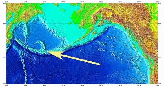
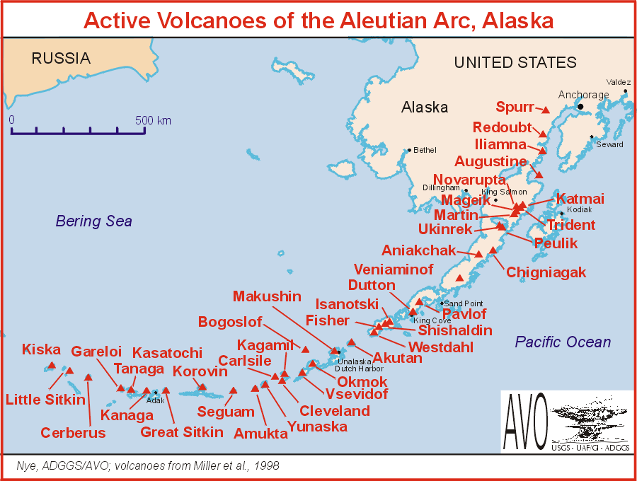
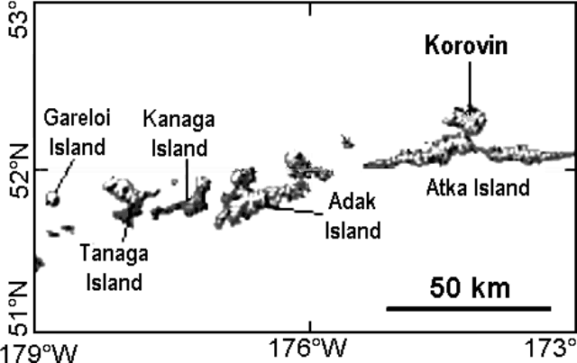
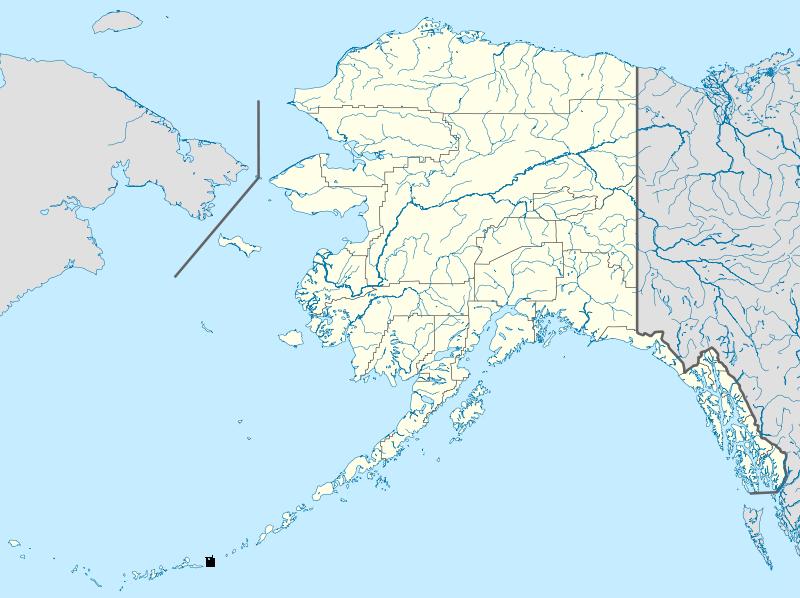
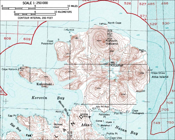
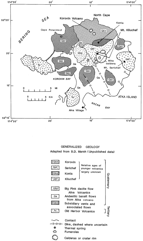
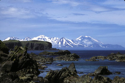
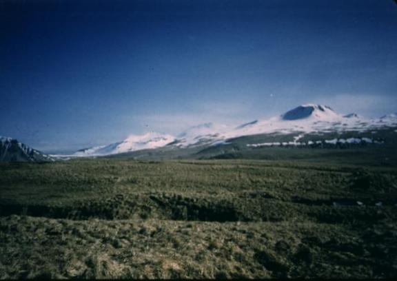
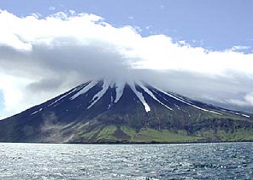
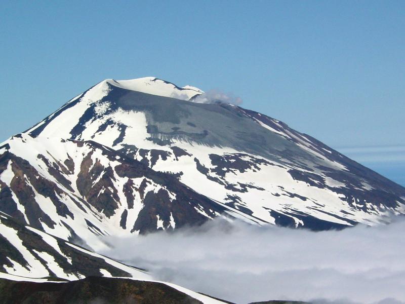
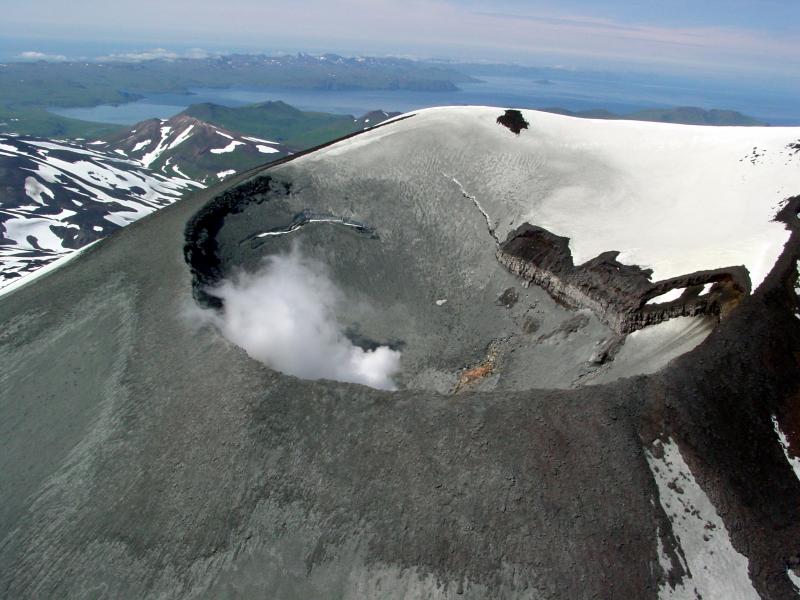
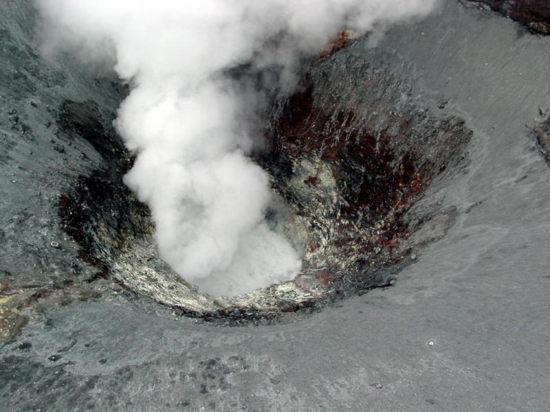
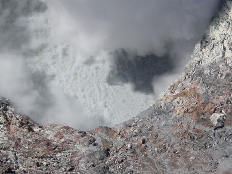
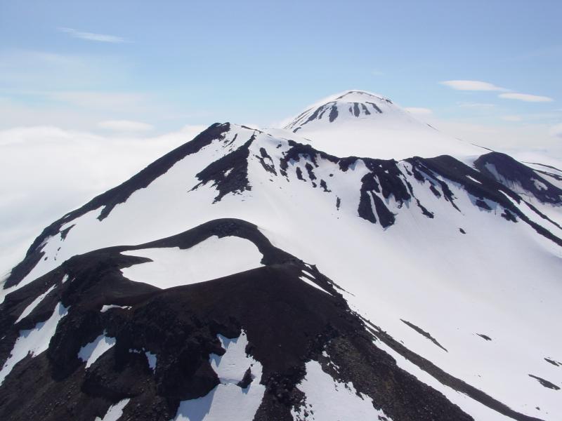
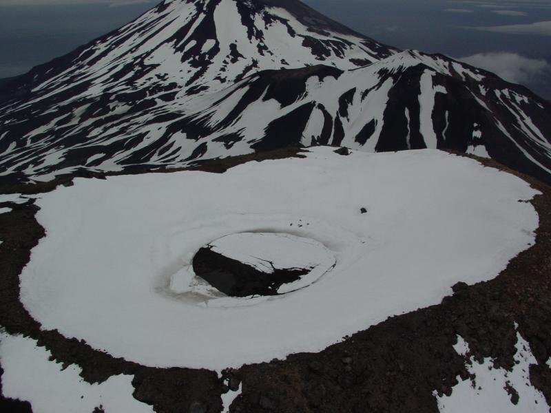
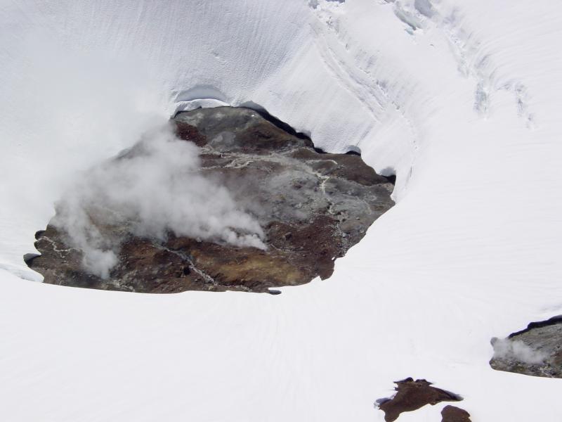
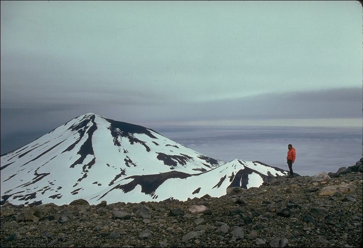
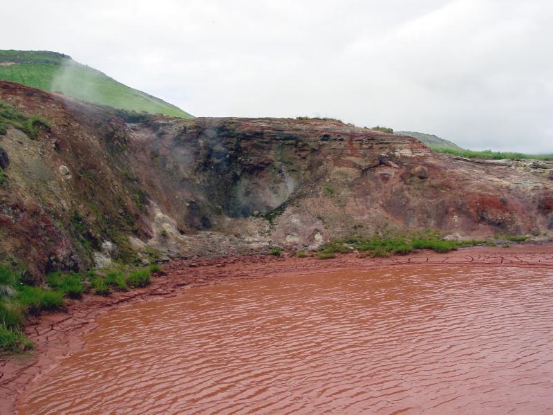
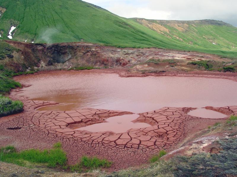
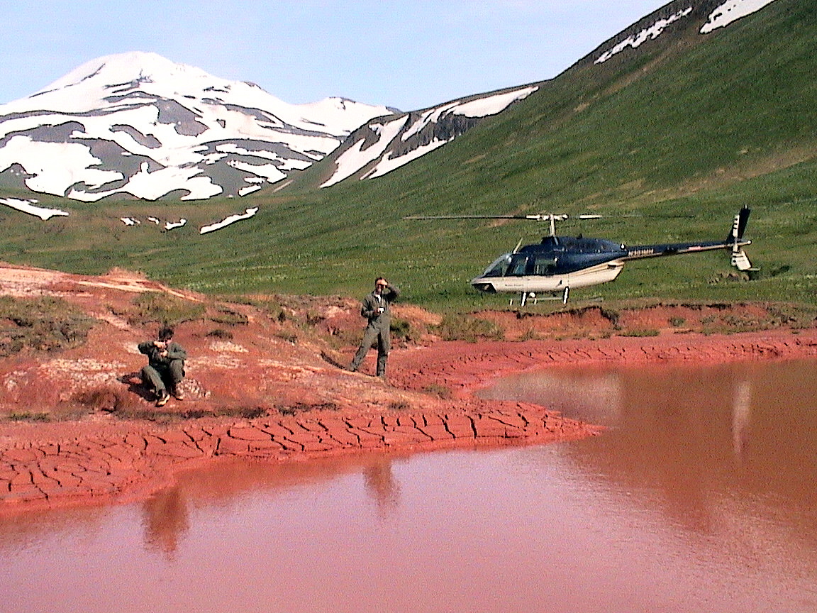

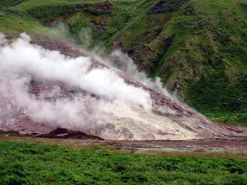
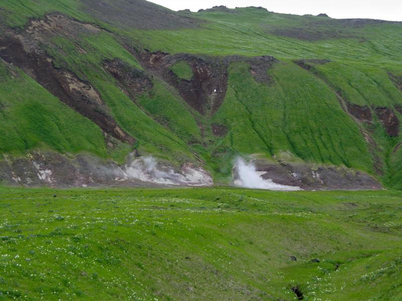
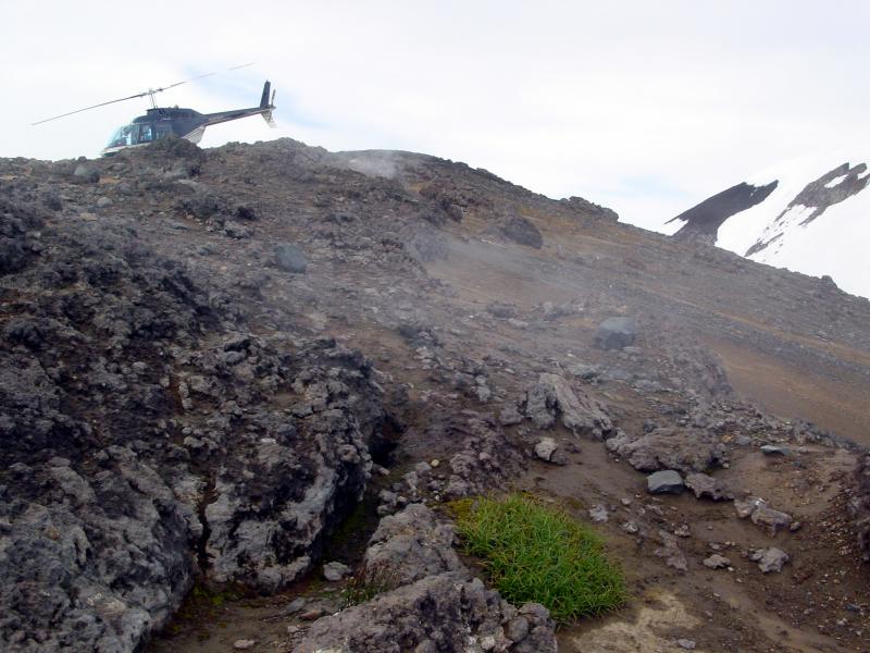
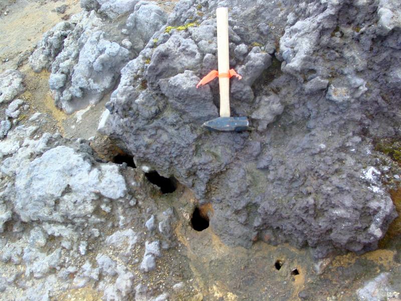
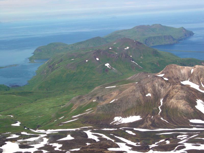
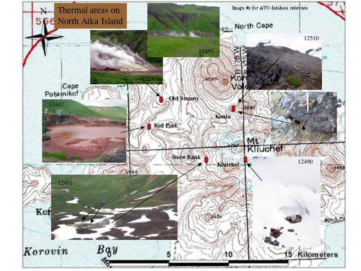
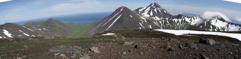
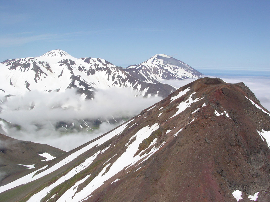
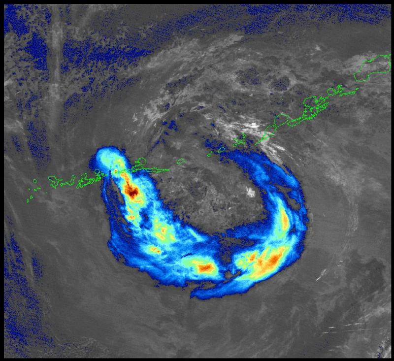
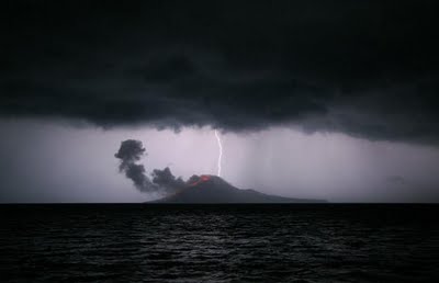
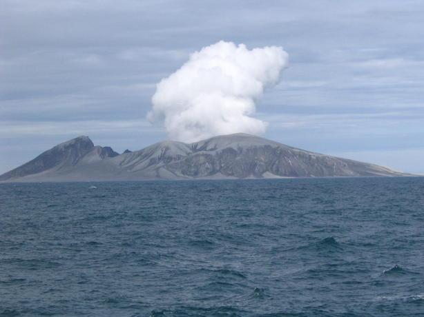
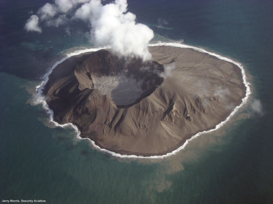

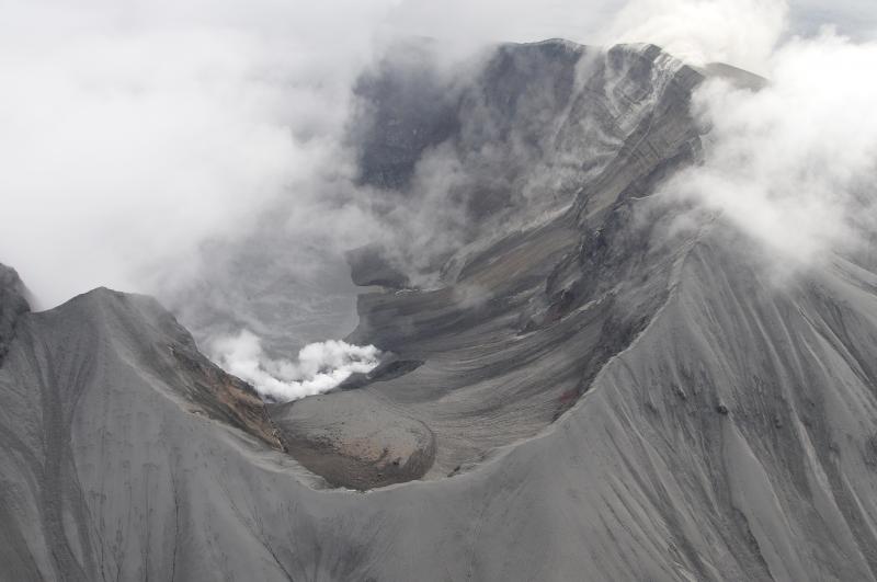
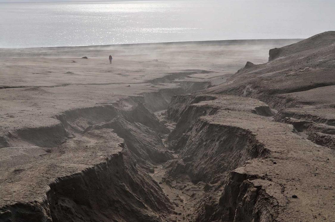
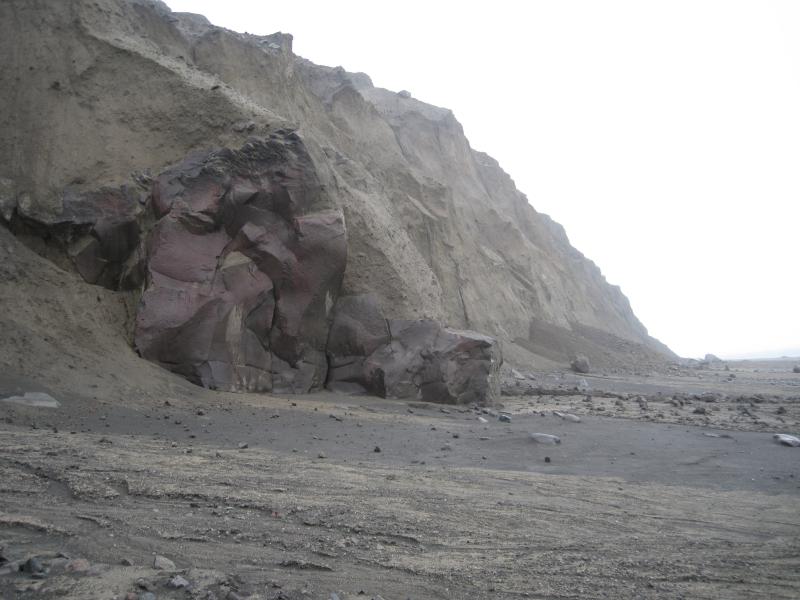
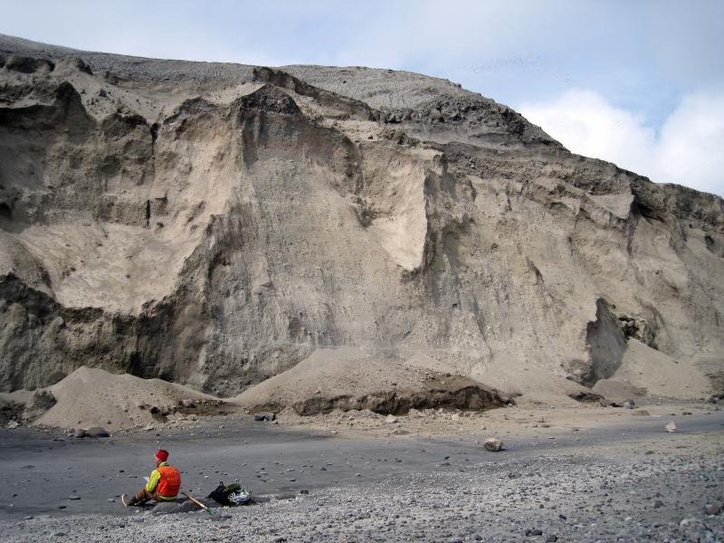
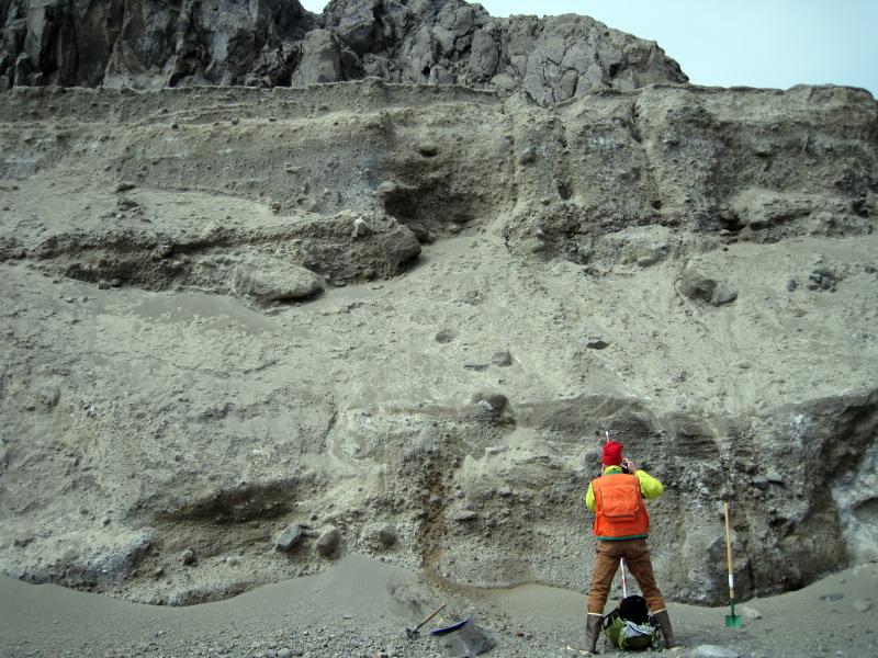
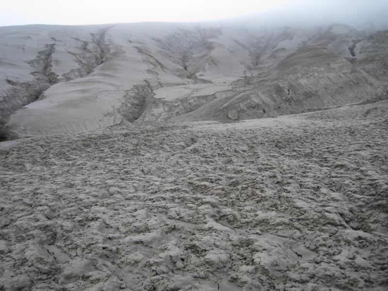
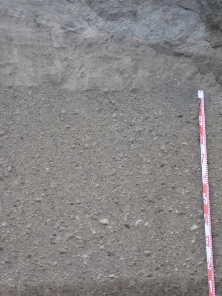
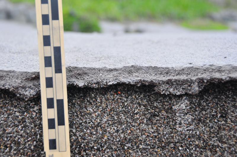
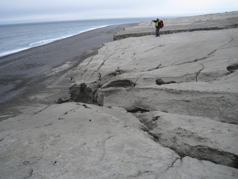
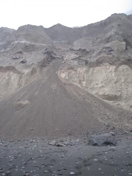
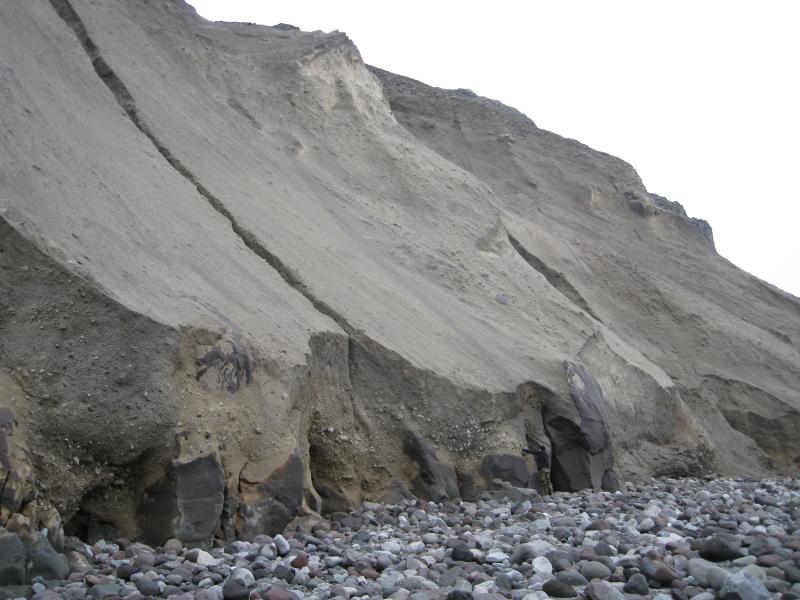
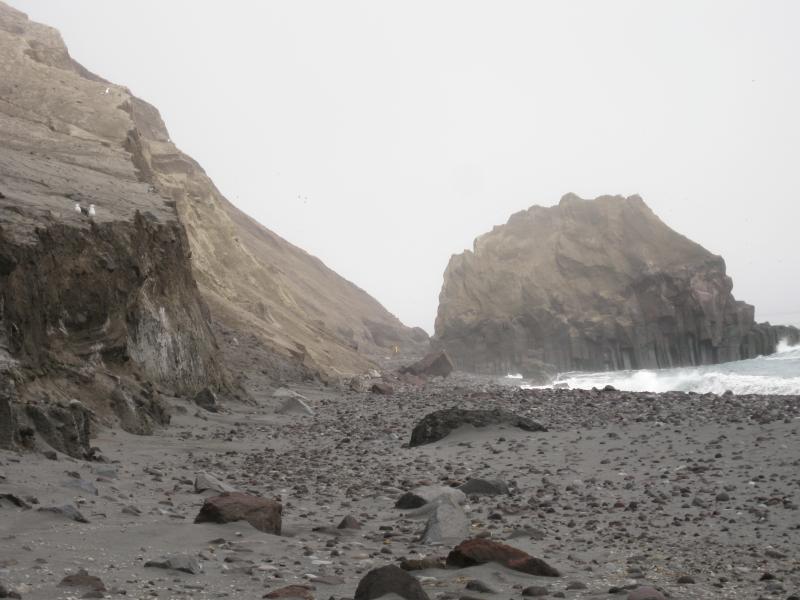
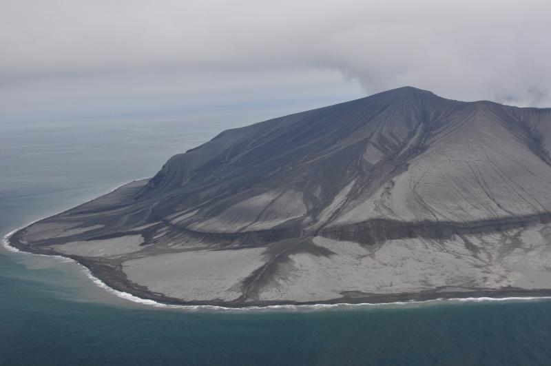
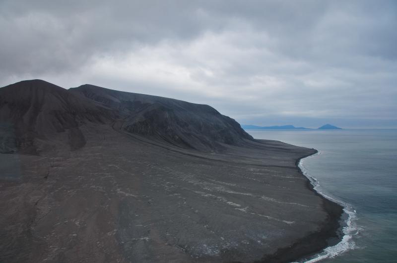
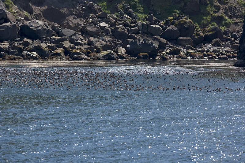
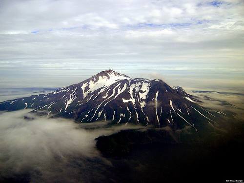
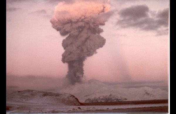

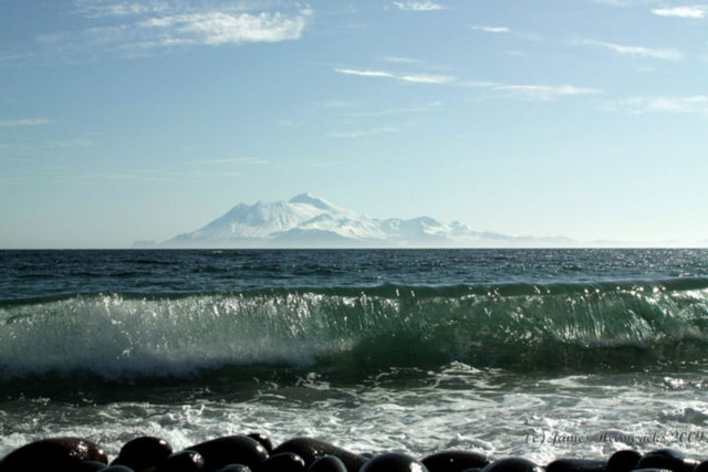
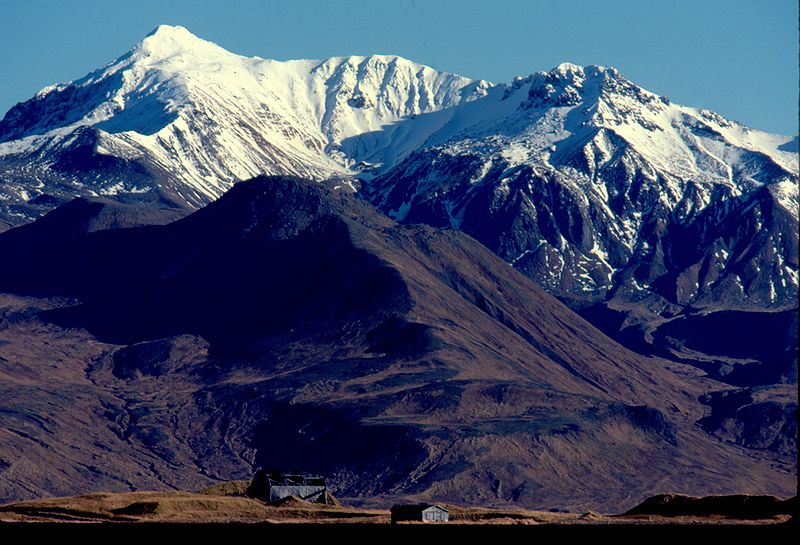
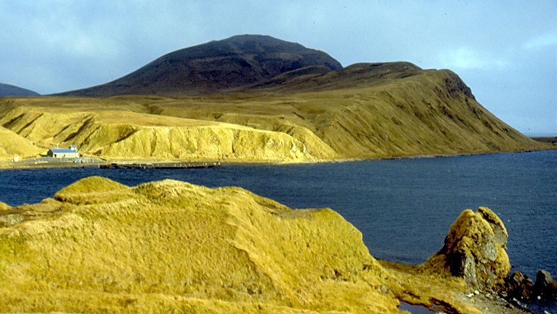
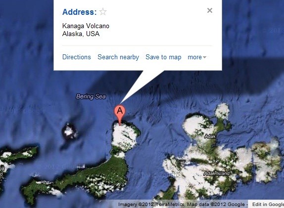
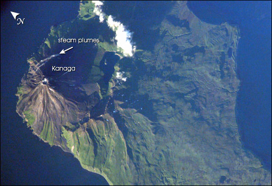
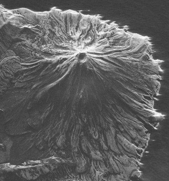
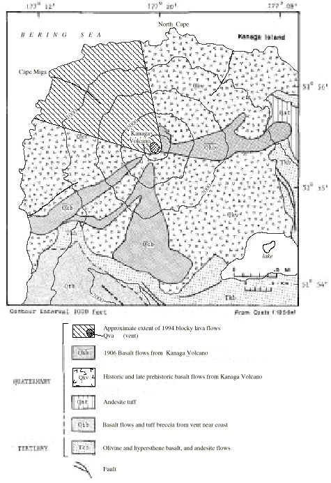
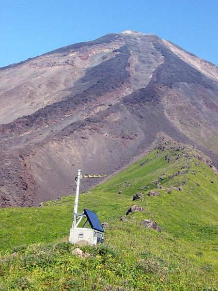
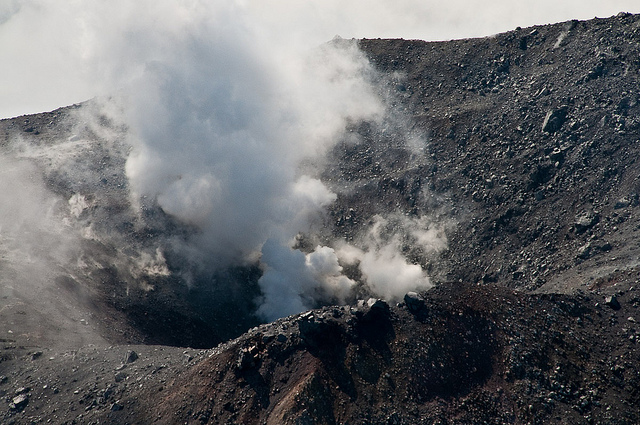

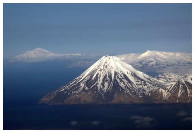
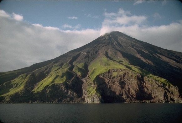
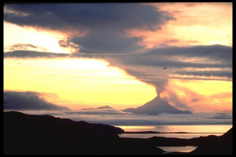
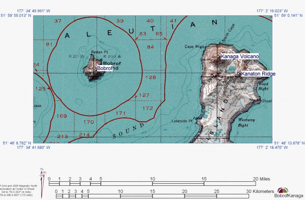
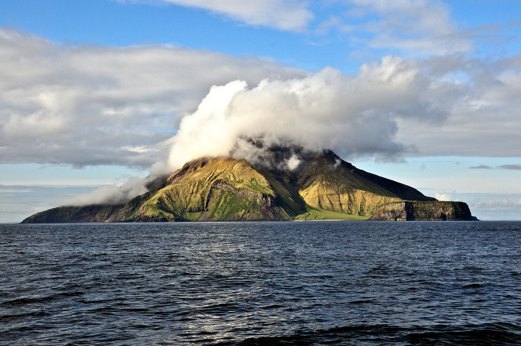
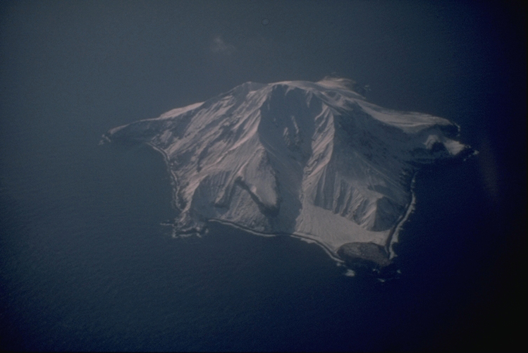
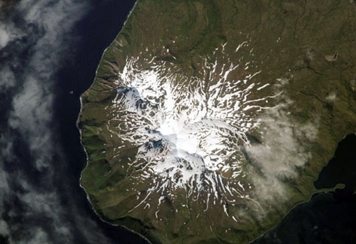
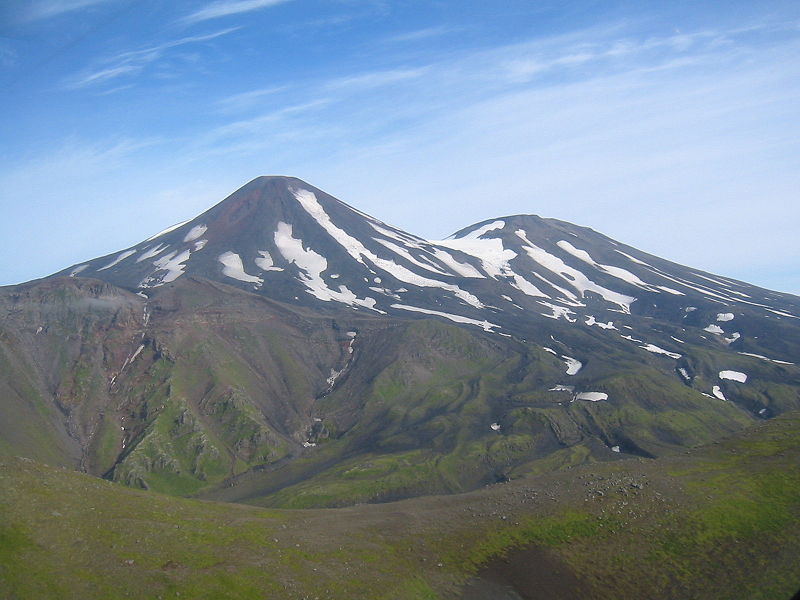
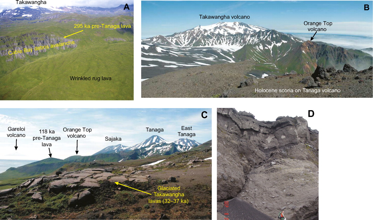
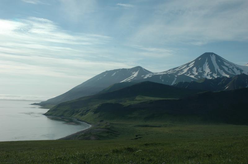
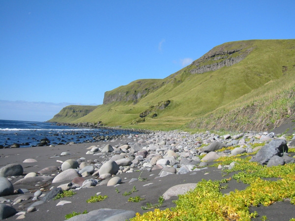
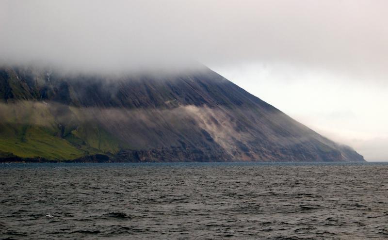
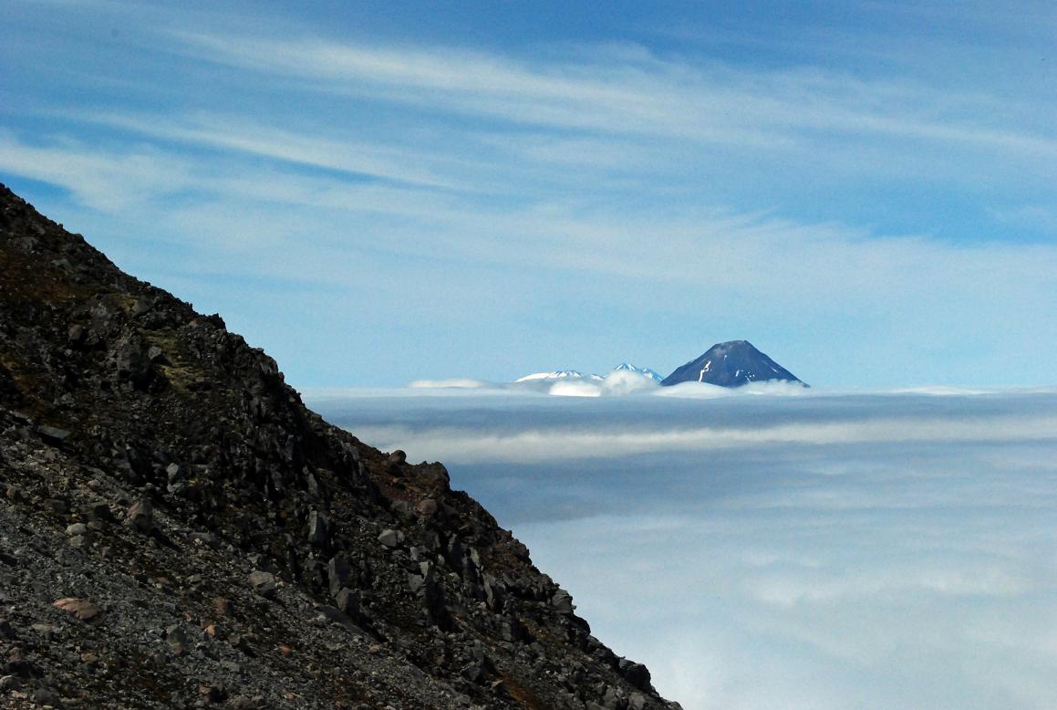
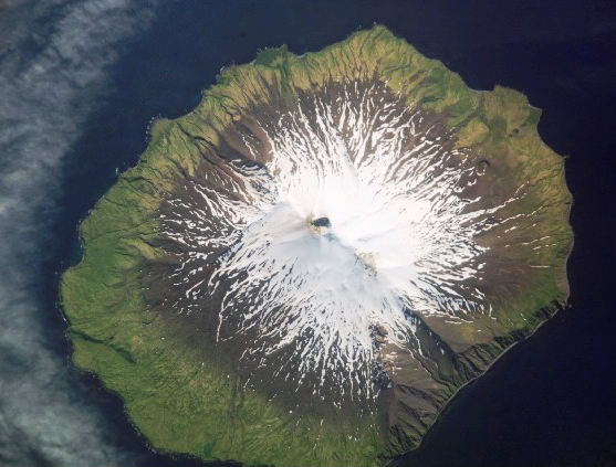
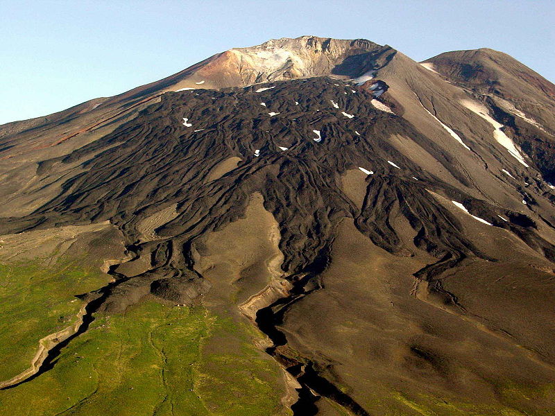
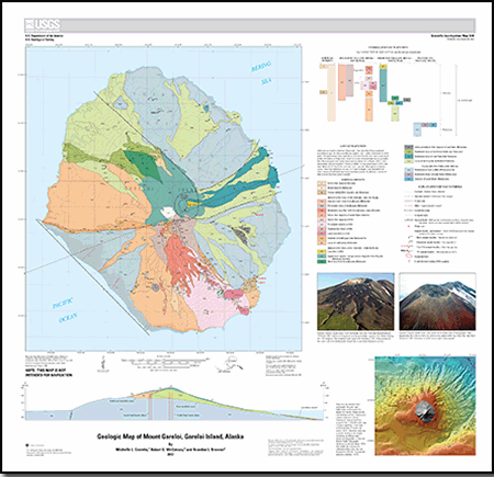
photo - http://blog.mailasail.com/kokiri/34
http://www.oceandots.com/pacific/aleutian/kasatochi.php
http://www.volcanolive.com/photos.html phillipines
http://volcano.oregonstate.edu/ mexico
http://www.sfos.uaf.edu/news/2003/0811volcano.html undersea
.
see http://www.melindawebster.com/aleutians2/
http://flickrhivemind.net/Tags/alaska,volcano/Interesting
next
Nature
Aleutian arc
the Alaska Volcano Observatory
next