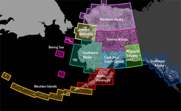
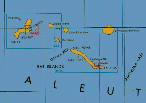
 | Aleutian Rat Islands |
http://www.geotimes.org/mar02/feature_amchitka.html |
http://planetevivante.wordpress.com/2009/03/24/eruption-volcanique-du-mont-redoubt-alaska/ |
description of historically active volcanoes - http://www.avo.alaska.edu/volcanoes/aleutians.php |
|
|
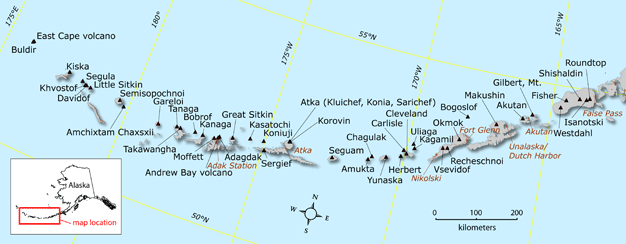
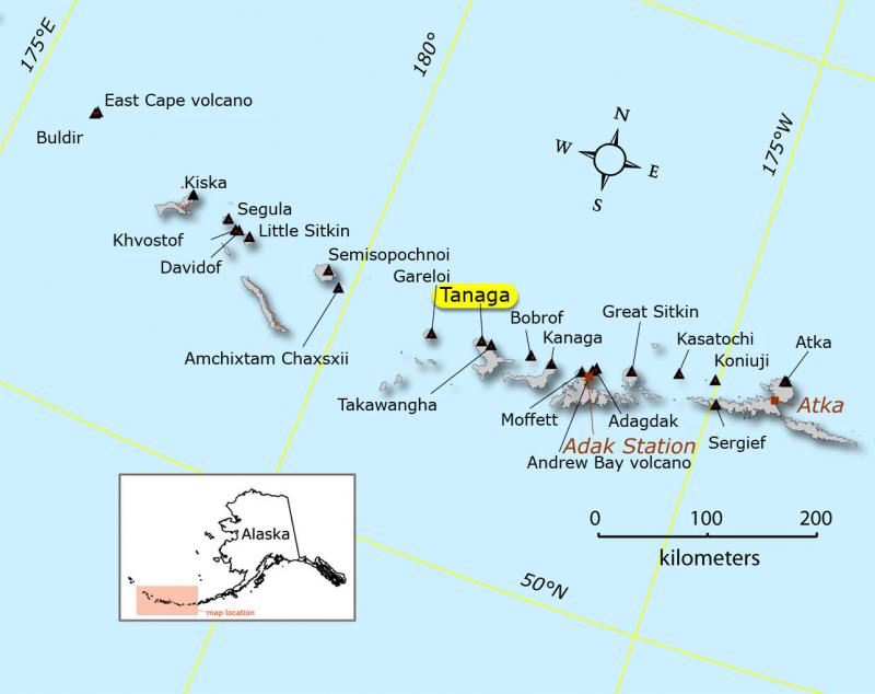
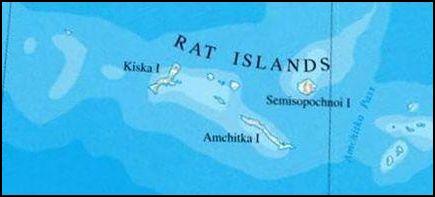
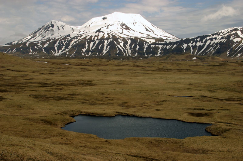
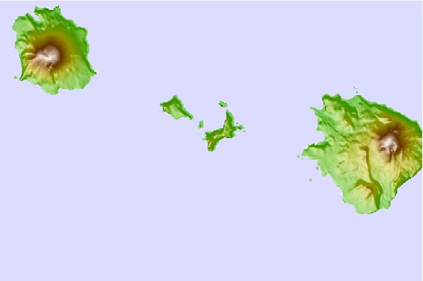
Map of Rat Islands showing major islands (line between Semisopochnoi Island and Amchitka Pass is the 180th meridian).The Rat Islands are a volcanic group of islands in the Aleutian Islands in southwest Alaska, between Buldir Island and the Near Islands group to its west, and Amchitka Pass and the Andreanof Islands group to its east, at about. The largest islands in the group are, from west to east, Kiska, Little Kiska, Segula, Hawadax or Kryssei, Khvostof, Davidof, Little Sitkin, Amchitka, and Semisopochnoi. The total land area of the Rat Islands is 934.594 km2. None of the islands are inhabited.The name Rat Islands is the English translation of the name given to the islands by Captain Fyodor Petrovich Litke in 1827 when he visited the Aleutian Islands on a voyage around the world. The islands are named so because of the rats that have ruled Rat Island since about 1780. As of 2009, the island is believed to be rat free. The Rat Islands are very earthquake-prone as they are located on the boundary of the Pacific and North American tectonic plates. In 1965, there was a major earthquake with a magnitude of 8.7 in the Rat |
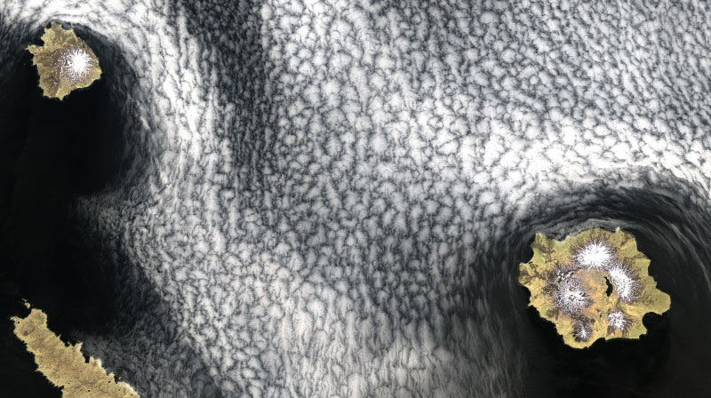
True color composite (RGB of bands 3-2-1 respectively) Landsat 7 ETM+ satellite image of Little Sitkin (upper left) and Semisopochnoi (lower right) in the Western Aleutian Islands of Alaska. The western portion of Amchitka Island is visible in the lower left of the image. The image was run through a 3x3 high pass filter and fused with the 15 meter panchromatic band data to produce a spatial resolution of 15 meters.Semisopochnoi Island (čÕņĶ±Ņ’Ņ„Ē¹ķ ) is part of the Rat Islands group. The island is uninhabited and provides an important nesting area for maritime birds. The island is of volcanic origin, containing several volcanoes including Mount Cerberus. It has a land area of 221.59 km2. It''s measuring 18 km in length and 20 km in width. Semisopochnoi has no native land mammals. Arctic foxes were introduced to the island during the 19th century for fur farming and removed in 1997. Most ground-nesting bird species (Aleutian Cackling Goose, Rock Ptarmigan) and most burrow-nesting seabirds (storm-petrels, Ancient Murrelets, Cassin''s Auklets, Tufted Puffins) were extirpated by foxes; Semisopochnoi Island is currently in the early stages of recovery. The island has remained free of Norway rats.The large Least and Crested Auklet colony near Sugarloaf Head is one of the largest among the nine auklet colonies in the Aleutian Islands. Crested Auklets and Least Auklets breed in one colony, located on the south facing slopes of Sugarloaf Peak volcano and its associated cinder cones near Sugarloaf Head. Semisopochnoi Island also supports a significant population of Red-faced Cormorants.In total, Semisopochnoi supports well over a million seabirds, most of which are Least Auklets or Crested Auklets.http://en.wikipedia.org/wiki/Semisopochnoi_Island |
True color composite (RGB of bands 3-2-1 respectively) Landsat 7 ETM+ satellite image of Semisopochnoi in the Western Aleutian Islands of Alaska. The image was run through a 3x3 high pass filter and fused with the 15 meter panchromatic band data to produce a spatial resolution of 15 meters. North is up in the image -http://www.avo.alaska.edu/volcanoes/volcimage.php?volcname=Semisopochnoi |
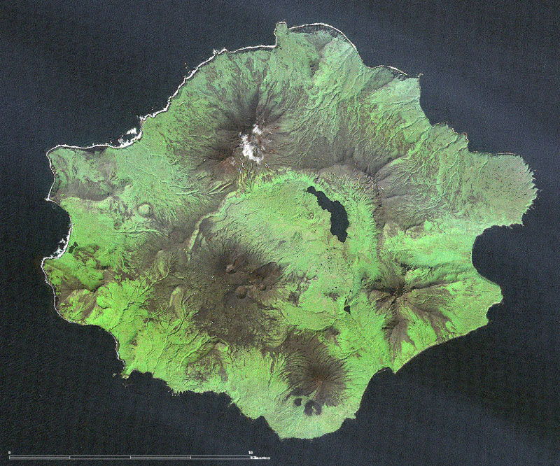
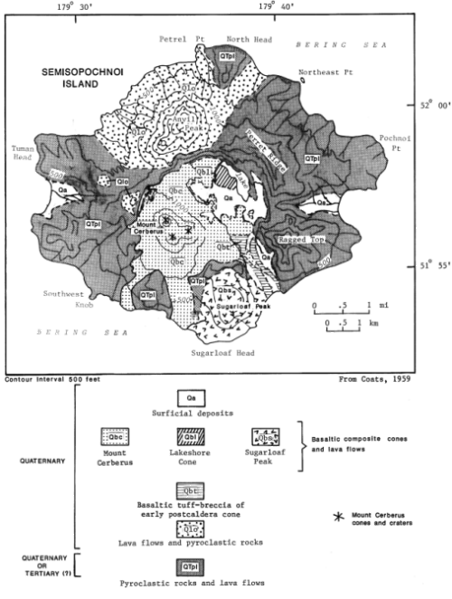
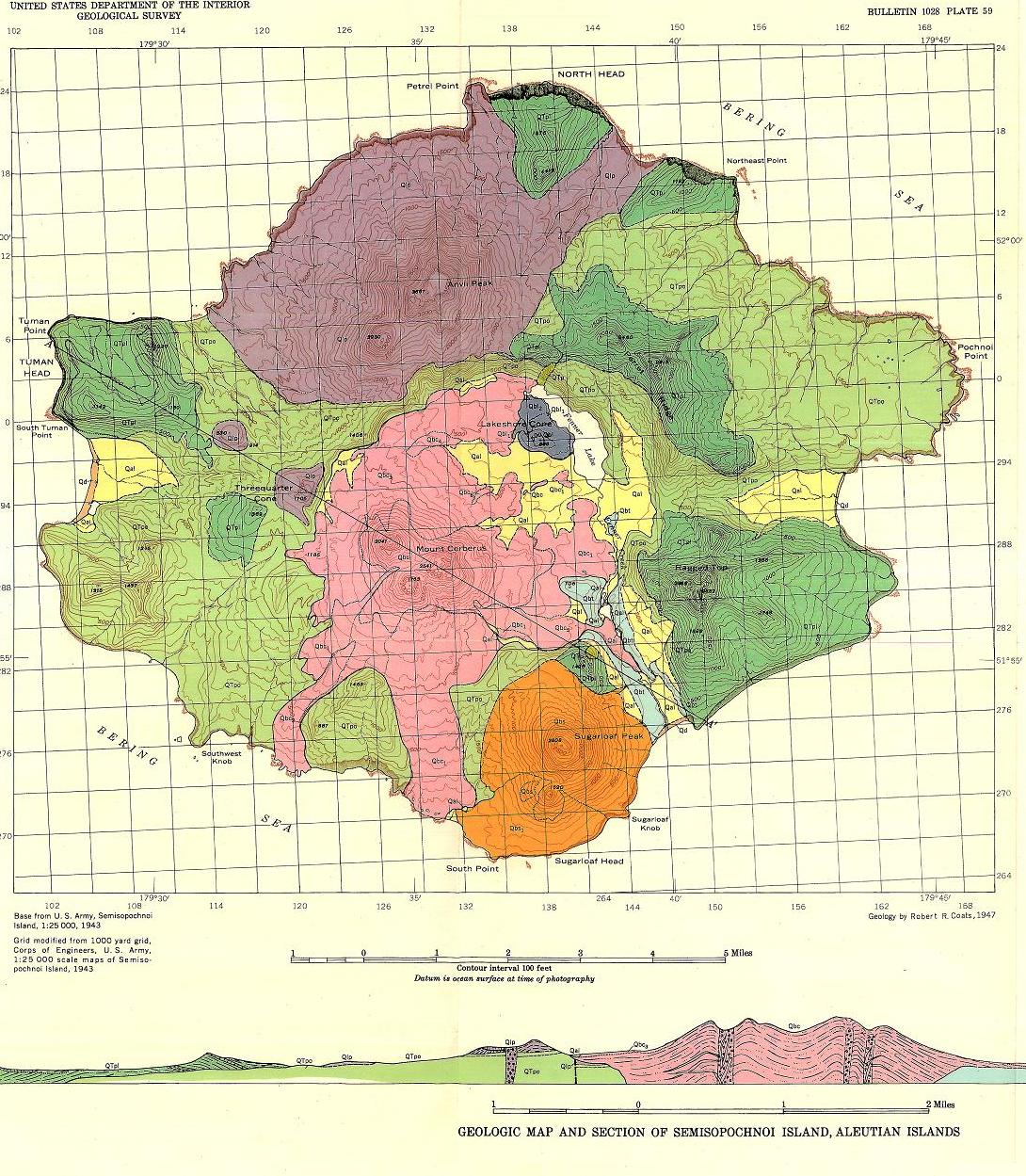
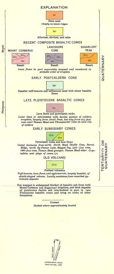
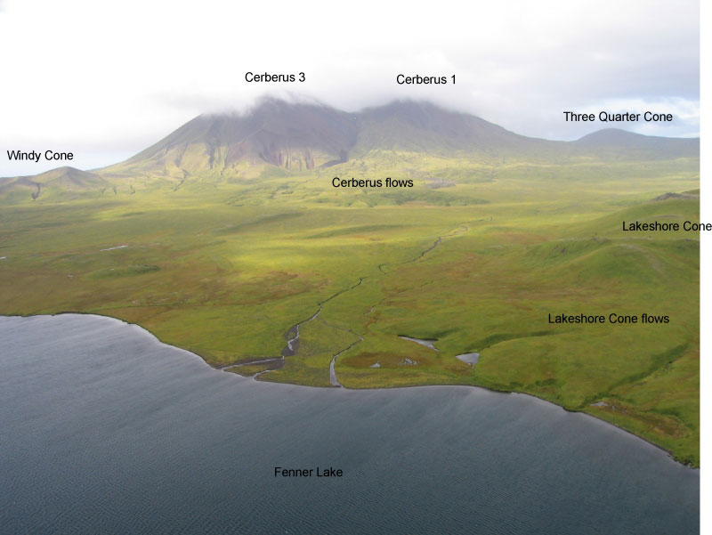
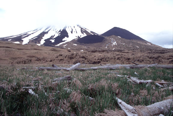
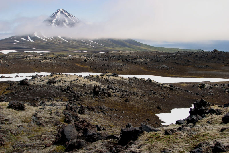
From Wood and Kienle (1990): "Semisopochnoi is the largest young volcanic island in the western Aleutians and is composed of a variety of volcanic landforms. Basaltic pyroclastic material built a shield of ~20 km wide (at sea level) which culminated in a post-glacial pumice and ash eruption of dacite and andesite, producing an 8-km-wide caldera. Smaller composite cones are both pre- and post-glacial. Mount Cerberus is the most active of the three younger cones within the caldera. These young cones are dominantly two-pyroxene, high-alumina basalt, and andesite. One young composite cone (Sugarloaf) has olivine basalt. Dacite and andesite are found among the eruptive products of the pre caldera shield. Much of the island is covered by basaltic to andesitic ash derived from the younger cones. Semisopochnoi''s tholeiitic differentiation trend (iron is enriched as silica increases) and relatively large volume are common in volcanoes near segment boundaries. Semisopochnoi is also on a small submarine ridge that extends northward as a part of the scorpion-tail-shaped Bower''s Ridge; it is unclear if this setting influences its volcanism. An historic eruption of Semisopochnoi was reported in 1873, and at least four others may have occurred in the previous hundred years, but documentation is scanty. These eruptions apparently emanated from the flanks of Mount Cerberus; the most recent flow appears to be less than a century old." http://www.avo.alaska.edu/volcanoes/volcimage.php?volcname=Semisopochnoi http://www.avo.alaska.edu/volcanoes/volcinfo.php?volcname=semisopochnoi http://www.avo.alaska.edu/volcanoes/volcimage.php?volcname=Semisopochnoi |
This map is from Coats, R.R., 1959, Geologic Reconnaissance of Semisopochnoi Island, western Aleutian Islands, Alaska, U.S.G.S. Bulletin 1028, 477-517.Please cite Coats (1959) when using this image. - http://www.avo.alaska.edu/images/image.php?id=546 http://www.avo.alaska.edu/images/dbimages/1109711891_14_10.jpg |
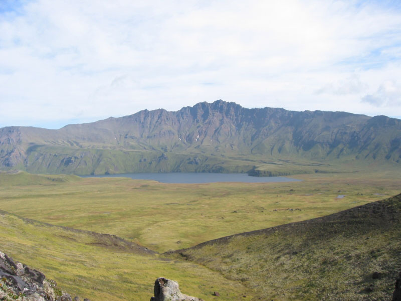
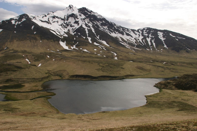
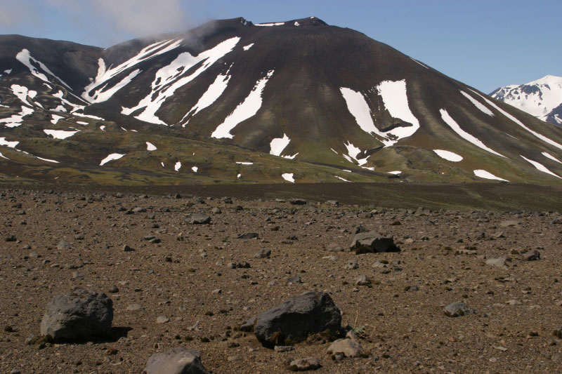
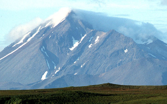
Semisopochnoi, the largest subaerial volcano of the western Aleutians, is 20 km wide at sea level and contains a caldera 8 km wide. It formed as a result of collapse of a low-angle, dominantly basaltic volcano following the eruption of a large volume of dacitic pumice. The high point of the island is 1,221 meter Anvil Peak, a double-peaked cone that forms much of the island''s northern part. The three-peaked, 774-meter high Mount Cerberus is a volcano within the caldera. Each of the peaks contains a summit crater; lava flows on the northern flank of Cerberus appear younger than those on the southern side. Other post-caldera volcanoes include the symmetrical 855 m high Sugarloaf Peak south-southeast of the caldera and Lakeshore Cone, a small cinder cone at the edge of Fenner Lake in the northeast part of the caldera. Most documented historical eruptions have originated from Cerberus, although Coats (1950) considered that both Sugarloaf and Lakeshore Cone within the caldera could have been active during historical time. Semisophochoi''s last known volcanic eruption was in April 1987. An historic eruption of Semisopochnoi was reported in 1873, and at least four others may have occurred in the previous hundred years, but documentation is scanty. These eruptions apparently emanated from the flanks of Mount Cerberus; the most recent flow appears to be less than a century old. http://en.wikipedia.org/wiki/Semisopochnoi_Island |
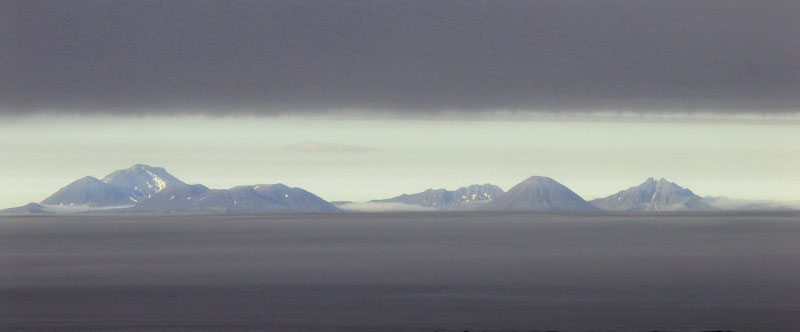
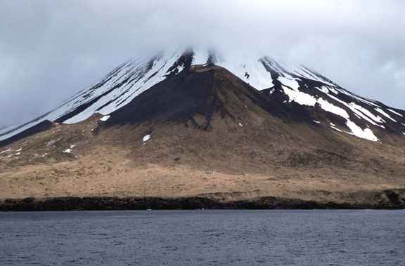
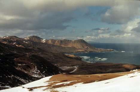
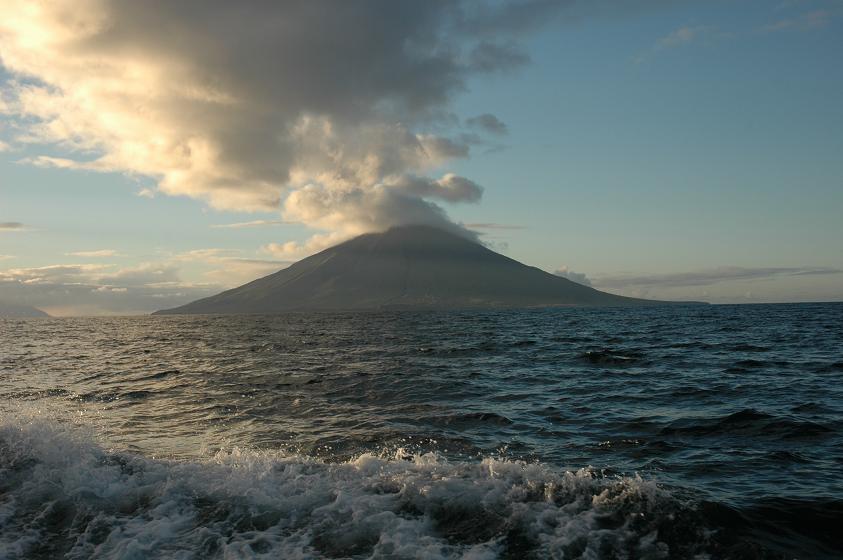
Semisopochnoi from Amchitka through a brief break in the fog. |
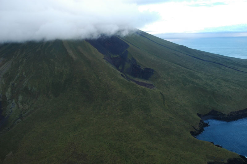
Annotated view of inside Semisopochnoi caldera http://www.avo.alaska.edu/volcanoes/volcimage.php?volcname=Semisopochnoi |
Semisopochnoi island is 21 km x 18. It is the largest of the young western Aleutian volcanic islands. Semisopochnoi, view of Sugarloaf Head (in foreground) and Sugarloaf Peak (in background). Image courtesy of Ian L. Jones, Department of Biology, Memorial University. |
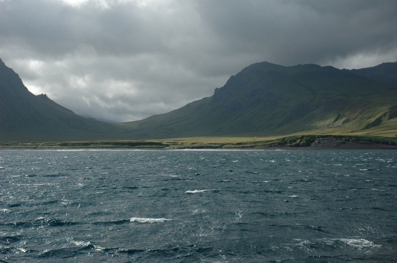
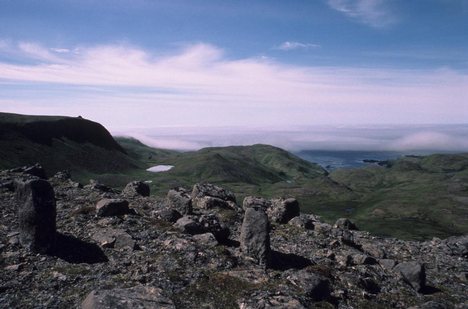
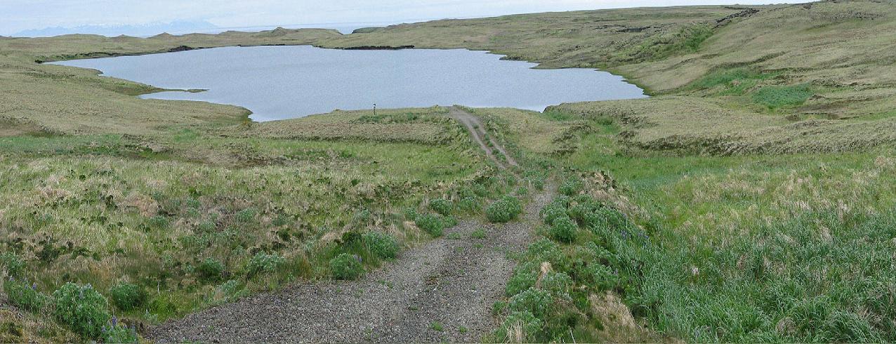
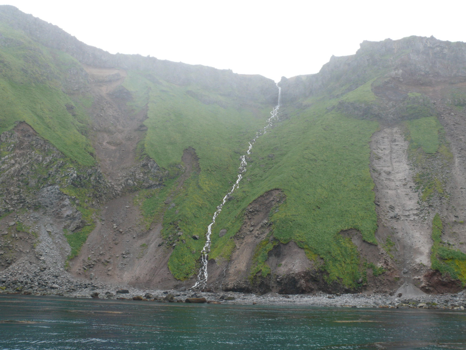
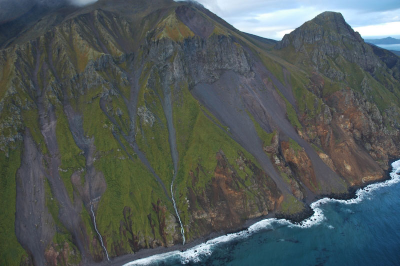
View westward from the East Bight anchorage at Semisopochnoi Island. This unnamed valley heads at the caldera rim. Ragged Top out of photo to left. This beach was the staging area for seismic installation and geolgic work in 2005. The Maritime Maid spent three nights anchored here |
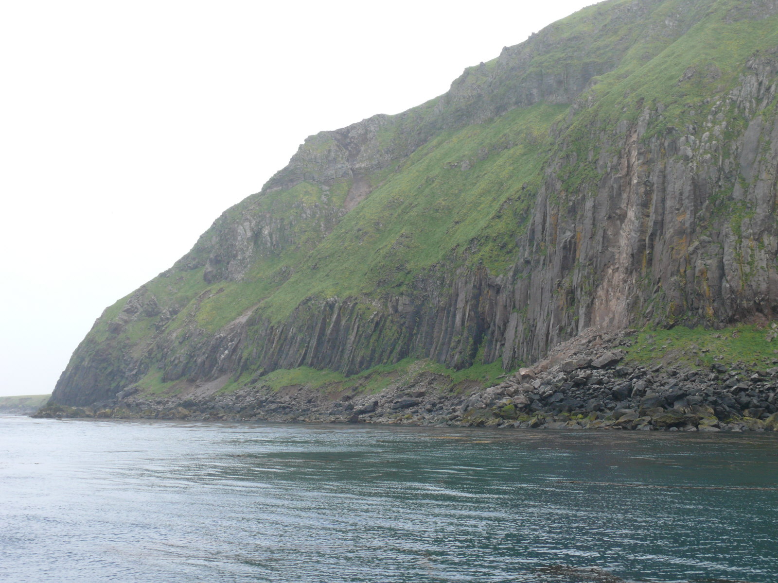
Ragged Top, Semisopochnoi Caldera, view from the east flank of Cerberus http://www.avo.alaska.edu/volcanoes/volcimage.php?volcname=Semisopochnoi |
Semisopochnoi Caldera, Fenner Lake in the distance. Taken from a cinder and spatter cone on the east flank of Cerberus http://www.avo.alaska.edu/volcanoes/volcimage.php?volcname=Semisopochnoi |
Semisopochnoi, view of Ragged Top from the west. Image courtesy of Ian L. Jones, Department of Biology, Memorial University http://www.avo.alaska.edu/volcanoes/volcimage.php?volcname=Semisopochnoi |
Semisopochnoi, looking northeast at cinder cones and base of Sugarloaf Peak. Image courtesy of Ian L. Jones, Department of Biology, Memorial University |
Semisopochnoi, view of Sugarloaf Peak from the west. Image courtesy of Ian L. Jones, Department of Biology, Memorial University |
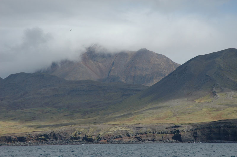
Semisopochnoi, view of Cerberus from the south. Image courtesy of Ian L. Jones, Department of Biology, Memorial University |
Semisopochnoi, view of Anvil Peak from the south. Image courtesy of Ian L. Jones, Department of Biology, Memorial University http://www.avo.alaska.edu/volcanoes/volcimage.php?volcname=Semisopochnoi |
Eastern Cerberus Cone, Semisopochnoi Caldera http://www.avo.alaska.edu/volcanoes/volcimage.php?volcname=Semisopochnoi |
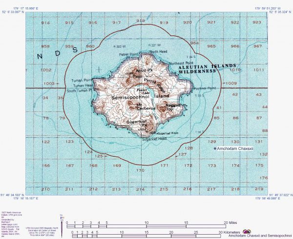
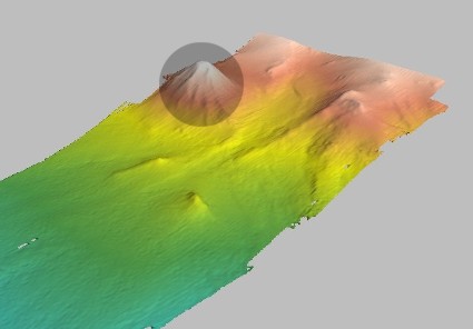
Topographic map of Semisopochnoi Island and showing location of submarine Amchixtam Chaxsxii volcano -http://www.avo.alaska.edu/images/image.php?id=2903 |
This image of submarine topography shows a previously unknown volcano mapped by Jennifer Reynolds (UAF School of Fisheries and Ocean Sciences), during an oceanographic cruise in 2003 funded by the North Pacific Research Board. The purpose of the cruise was to create seafloor maps for studies of deep-water coral habitat. The 640-m tall volcano. Image courtesy of Jennifer Reynolds.Please contact Jennifer Reynolds for permission to use this image http://avo.alaska.edu/image_full.php?id=202 |
Amchitka, Rat, Segula, Little Sitkin Islands |
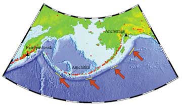
Amchitka Island is one of many islands of the Aleutian Island chain in western Alaska. Amchitka Island, 55 km long and 5.5 km wide, lies in the western portion of the Aleutian Volcanic Arc which developed geologically about 55 MA. New knowledge about plate tectonics along with current observations show this region to be one of the planet''s most dynamically active geological regions. More than 90 percent of the seismic energy recorded within the United States during the instrumental record was within the Aleutian Volcanic Arc. For example, magnitude-8 earthquakes occur at approximately decadal time intervals along the Aleutian arc, with three of the six largest earthquakes occurring between 1957 and 1965. Amchitka Island is located at 51░ 32'' N Latitude, 179░ 00'' E Longitude and has an approximate area of 300 km." Amchitka Island is the site of three underground nuclear detonations conducted on 29 October 1965 ("Long Shot"), 2 October 1969 ("Milrow"), and 6 November 1971 ("Cannikin"). Long Shot was detonated at a depth of 700 m and had an 80 kiloton yield. It was detonated shortly after a nearby magnitude-8.7 earthquake to determine whether monitoring techniques could differentiate between natural seismicity and nuclear explosions. Milrow was a seismic calibration test detonated at a depth of 1,220 m with an approximate one megaton yield. Cannikin, a test of the proposed Spartan missile warhead, was detonated at a depth of 1,790 meters, with a yield slightly less than five megatons. http://community-2.webtv.net/CobraBall/Amchitka/ |
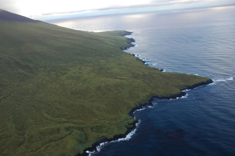
Amchitka is a volcanic, tectonically unstable island in the Rat Islands group of the Aleutian Islands in southwest Alaska. It is part of the Alaska Maritime National Wildlife Refuge. The island is about 68 km long, and from 3 to 6 km wide. The area has a maritime climate, with many storms, and mostly overcast skies.Amchitka was populated for more than 2,500 years by the Aleut people, but has had no permanent population since 1832. The island has been part of the United States since the Alaska Purchase of 1867. During World War II, it was used as an airfield by US forces in the Aleutian Islands Campaign.Amchitka was selected by the United States Atomic Energy Commission to be the site for underground detonations of nuclear weapons.The eastern part of the island is a lowland plateau, with isolated ponds[ and gently rolling hills. There is low but abundant vegetation, consisting of mosses, lichens, liverworts, ferns, grasses, sedges, and crowberry. The center of the island is mountainous, and the western end is barren and vegetation is sparse. Amchitka has a maritime climate, often foggy and windswept, with cloud cover 98 percent of the time. While temperatures are moderated by the ocean, storms are frequent. Geologically, the island is volcanic, being a part of a small crustal block on the Aleutian Arc that is being torn apart by oblique subduction. It is "one of the least stable tectonic environments in the United States." http://en.wikipedia.org/wiki/Amchitka |
Amchitka Island, Kirilof Point |
Amchitka Island, Harlequin Beach |
Amchitka Island |
Amchatka landscape |
Amchatka |
Amchitka Island, Cannikin Lake. This is the lake formed by the 1971 underground detonation of a 5 megaton nuclear warhead |
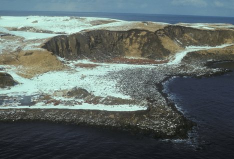
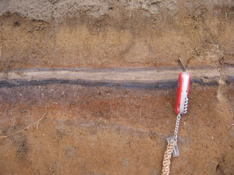
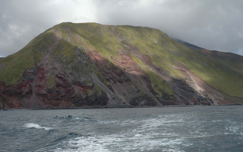
Tephra-fall deposit on Amchitka Island near Constantine Harbor. Candidate for the Semisopochnoi Caldera forming unit http://www.avo.alaska.edu/volcanoes/volcimage.php?volcname=Semisopochnoi |
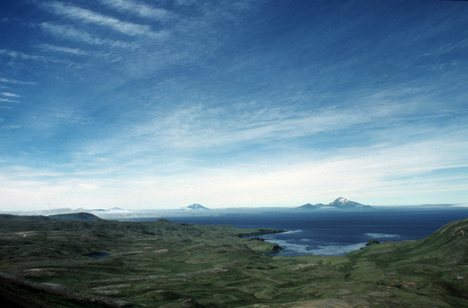
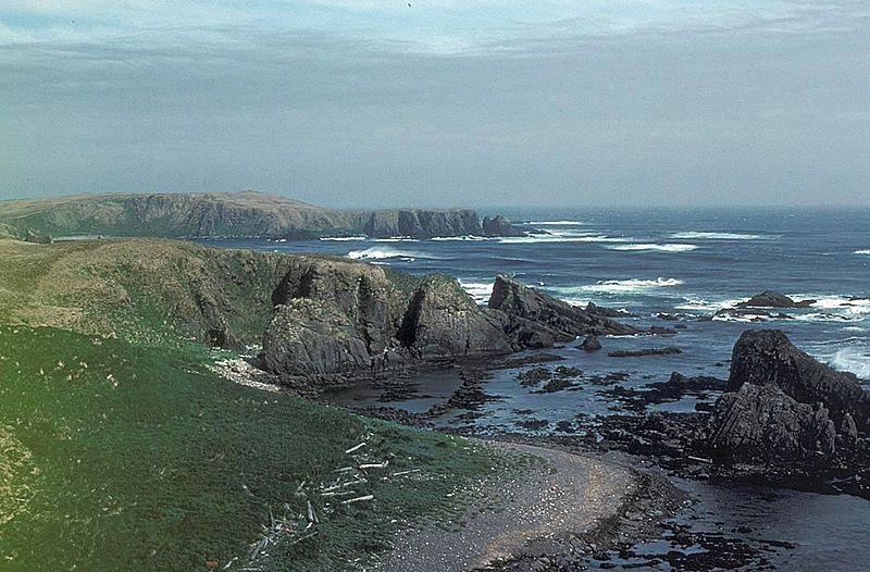
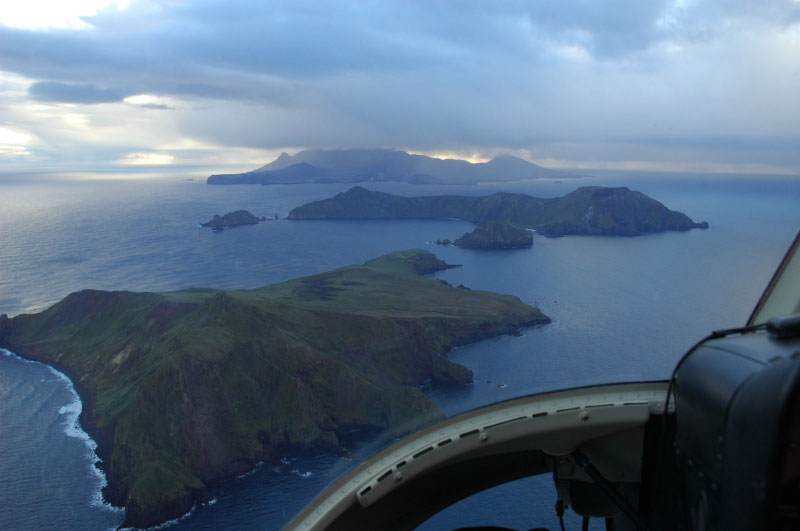
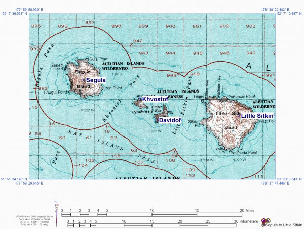
View to the east of Kvostof and Davidof Islands (near and mid ground), Little Sitkin on the horizon. The small islets are Lopy Island (l) and Pyramid Island (r).http://www.avo.alaska.edu/images/image.php?id=4551 |
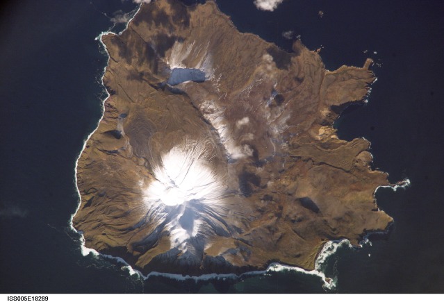
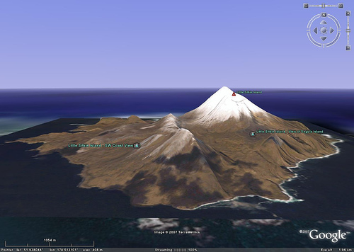
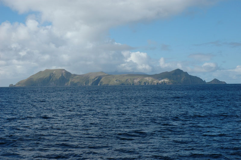
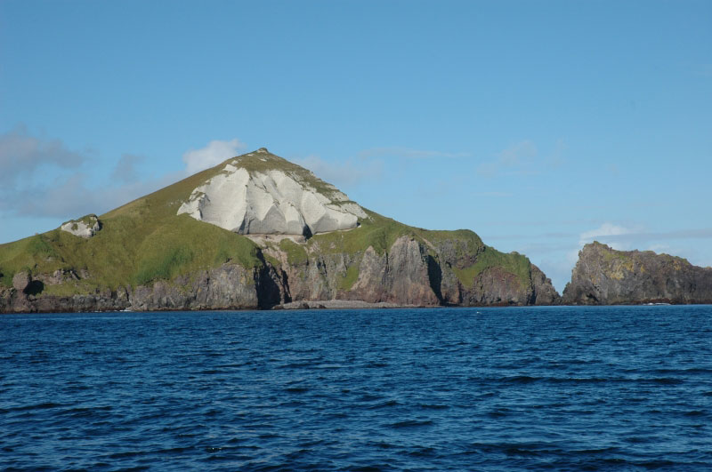
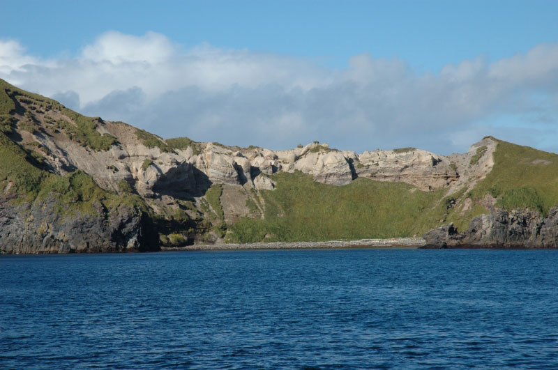
Little Sitkin Island is a volcanic island in the Rat Islands archipelago about three miles east of Davidof Island..Little Sitkin is roughly circular and about 6 miles in diameter. The interior is extremely rugged and mountainous; only the lower slopes are grass covered. There are two prominent peaks, one 1300 km high in the northeast part of the island and the other 650m high in the southern part. Numerous streams are on the island but no lakes or ponds. The coast is enerally bold, rocky, and precipitous, with a fringe of kelp 200 to 400 yards wide. Small steam jets and hot springs are in the valley at the head of William Cove on the northwest of the island.Little Sitkin is a stratovolcano that erupted probably in 1776, 1828, and 1900. The 1776 eruption was probably explosive. The volcano has had three cone building episodes separated by the formation of two calderas. A summit crater caps the youngest cone, about 3 miles in diameter at the base.The active stratovolcano on Little Sitkin Island occurs within the eroded remnants of a nested double caldera of probable late Pleistocene age. The older caldera (Caldera One) is about 4.8 km in diameter and is centered slightly northeast of the island''s midpoint. The caldera formed at the site of a large stratovolcano, the remnants of which are the oldest rocks exposed on the island.A second stratovolcano was constructed almost entirely of lava flows within Caldera One and attained a height of about 900 m. A cataclysmic eruption, possibly in early post-glacial time, resulted in the formation of a second, smaller caldera (Caldera Two) that partially destroyed this cone. Caldera Two is elliptical in outline and measures 2.7 by 4 km; the inferred eastern and southern margins are coincident with those of Caldera One. Field relations suggest that the northern boundary of Caldera Two is a hinge along which a large block, comprising most of the Caldera One stratovolcano, was tilted southward during the caldera eruption. The highest peak on the island is on the post-caldera remnant of the second cone.A deposit of partly welded tuff up to 100 m thick extends from the remnant cone northwest across the Caldera Two boundary fault, to slightly beyond the inferred location of the Caldera One boundary fault. The deposit is thought to have been emplaced by one of more pyroclastic flows, possibly associated with formation of Caldera Two.Post-Caldera Two deposits are mainly lava flows. Two relatively recent aa flows have well developed levees; one originated from the breached central crater of Little Sitkin volcano, and the other from a fissure along the western trace of the Caldera One boundary fault http://en.wikipedia.org/wiki/Little_Sitkin_Island |
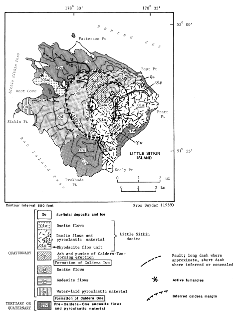
Little Sitkin Island occurs within the eroded remnants of a nested double caldera of probable late Pleistocene age. The older caldera (Caldera One) is about 4.8 km in diameter and is centered slightly northeast of the island''s midpoint. The caldera formed at the site of a large stratovolcano, the remnants of which are the oldest rocks exposed on the island (unit Qtw; Snyder, 1959). "A second stratovolcano was constructed almost entirely of lava flows (unit Qd) within Caldera One and attained a height of about 900 m. A cataclysmic eruption, possibly in early post-glacial time, resulted in the formation of a second, smaller caldera (Caldera Two) that partially destroyed this cone. Caldera Two is elliptical in outline and measures 2.7 by 4 km; the inferred eastern and southern margins are coincident with those of Caldera One. Field relations suggest that the northern boundary of Caldera Two is a hinge along which a large block, comprising most of the Caldera One stratovolcano, was tilted southward during the caldera eruption. The highest peak on the island is on the post-caldera remnant of the second cone. "A deposit of partly welded tuff up to 100 m thick (unit Qp) extends from the remnant cone northwest across the Caldera Two boundary fault, to slightly beyond the inferred location of the Caldera One boundary fault. The deposit is thought to have been emplaced by one of more pyroclastic flows, possibly associated with formation of Caldera Two (Snyder, 1959). "Post-Caldera Two deposits are mainly lava flows (units Qls, Qlp, and Qlw). Two relatively recent aa flows have well developed levees; one originated from the breached central crater of Little Sitkin volcano, and the other from a fissure along the western trace of the Caldera One boundary fault (Snyder, 1959)." http://www.avo.alaska.edu/volcanoes/volcinfo.php?volcname=Little%20Sitkin |
This image is found in Miller, T. P., McGimsey, R. G., Richter, D. H., Riehle, J. R., Nye, C. J., Yount, M. E., and Dumoulin, J. A., 1998, Catalog of the historically active volcanoes of Alaska: U.S. Geological Survey Open-File Report OF 98-0582, 104 p.,http://www.avo.alaska.edu/images/dbimages/1108671676_13_10.gif |
Little Sitkin - http://xpda.com/aleutians/littlesitkin/ |
Little Sitkin - http://xpda.com/aleutians/littlesitkin/ |
Little Sitkin - http://xpda.com/aleutians/littlesitkin/ |
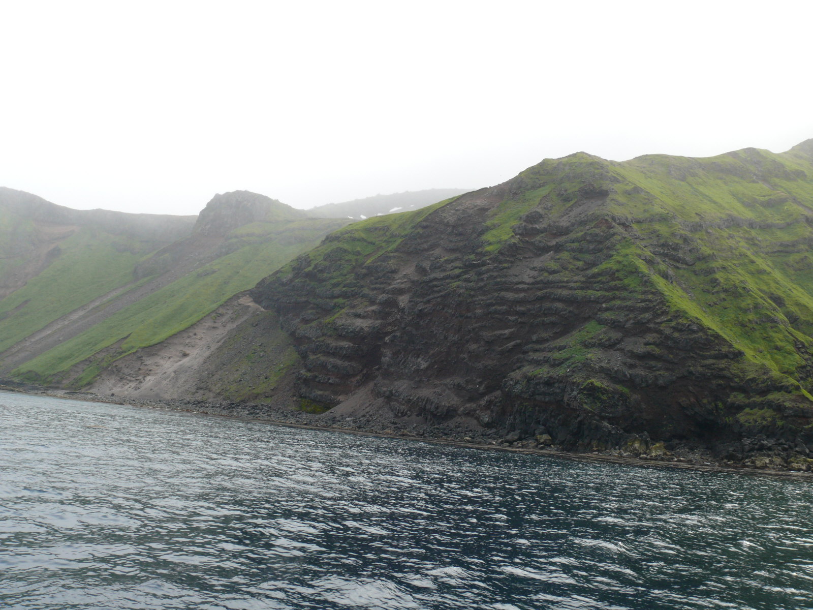
Little Sitkin Volcano southwest coastline. Modern cone in the clouds -http://www.avo.alaska.edu/volcanoes/volcimage.php?volcname=Little Sitkin |
Little Sitkin Volcano, southeast coastline -http://www.avo.alaska.edu/volcanoes/volcimage.php?volcname=Little Sitkin |
View of Little Sitkin, looking north across Rat Island. Image courtesy of Ian L. Jones, Department of Biology, Memorial University -http://www.avo.alaska.edu/volcanoes/volcimage.php?volcname=Little Sitkin |
North coast Little Sitkin http://www.avo.alaska.edu/volcanoes/volcimage.php?volcname=Little Sitkin- |
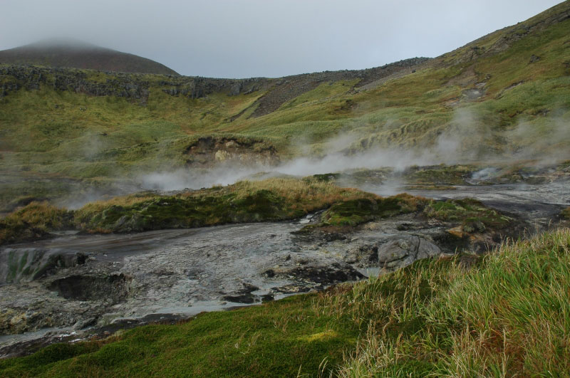
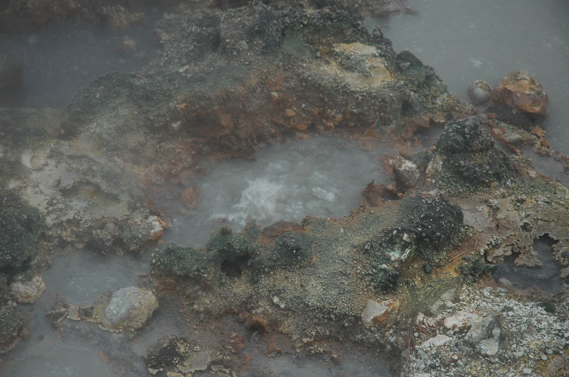
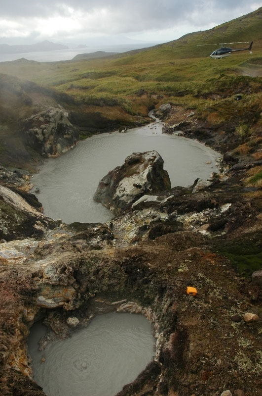
Fumaoles and acid-sulfacte (?) hot springs of Little Sitkin - this field is inland of West Cove -http://www.avo.alaska.edu/volcanoes/volcimage.php?volcname=Little Sitkin |
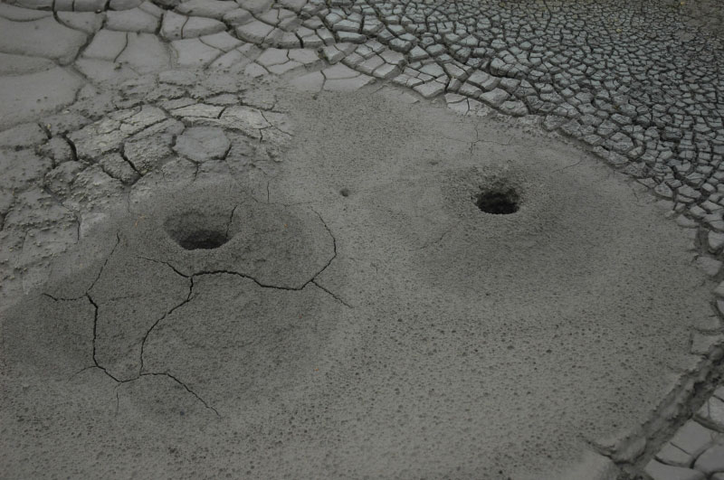
Fumaroles and acidic hot springs of Little Sitkin - this field is inland of West Cove. Inactive small mud volcanoes (~10-20 cm high) -http://www.avo.alaska.edu/volcanoes/volcimage.php?volcname=Little Sitkin |
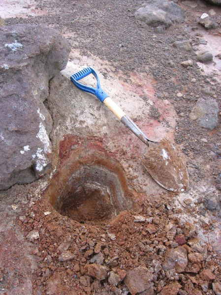
Phreatic (?) ash fall deposits west flank Little Sitkin -http://www.avo.alaska.edu/volcanoes/volcimage.php?volcname=Little Sitkin |
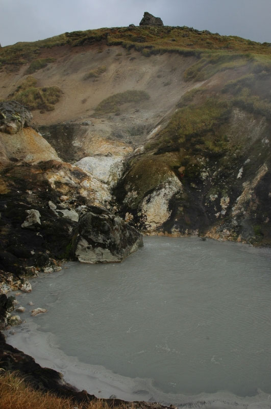
Boiling acidic water in the hot spring field on western Little Siktin.- http://www.avo.alaska.edu/volcanoes/volcimage.php?volcname=Little Sitkin |
Boiling acidic pool part of the hot springs of western Little Sitkin Island -http://www.avo.alaska.edu/volcanoes/volcimage.php?volcname=Little Sitkin |
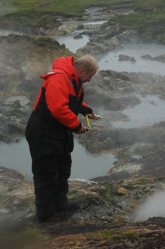
Fumaroles and acidic pools in the hot springs of Little Sitkin - this field is inland of West Cove. Guy Tytgat measures boiling point fumaroles- http://www.avo.alaska.edu/volcanoes/volcimage.php?volcname=Little Sitkin |
Fumaoles and acid-sulfacte (?) hot springs of Little Sitkin - this field is inland of West Cove -http://www.avo.alaska.edu/volcanoes/volcimage.php?volcname=Little Sitkin |
West Cove lava flow and vent area, Little Sitkin Volcano -http://www.avo.alaska.edu/volcanoes/volcimage.php?volcname=Little Sitkin |
Hawadax Island (Rat Island) is an island in the Rat Islands. The island has a land area of 26.7095 km2 and no permanent population. It is within the Alaska Maritime National Wildlife Refuge. It is 15 km in length and 5 km in width. The Rat Islands are very earthquake-prone as they are located on the boundary of the Pacific and North American tectonic plates. In 1965, there was a major earthquake with the magnitude 8.7 in the Rat Islands. The island was heavily infested with Brown rats, which are considered a nuisance invasive species due to their negative impact on the population of ground-nesting wild birds. The rats arrived on the island before 1780 due to a Japanese shipwreck. Since then, the rats have had a devastating effect on local seabirds that have no natural defenses against the rats. Invasive rats are also present on 16 other islands in the Aleutian chain.In 2007, the U.S. Fish and Wildlife Service, which manages the Refuge, was formulating plans to eradicate the rats, without negatively affecting other species. Scientists considered the island a test case for other eradications in less isolated environments. The eradication plan is modeled on a successful one to eliminate the Arctic fox from various Aleutian islands, where they were deliberately introduced for breeding.In June 2009, the island was declared rat-free for the first time in 229 years, although the site will be continually monitored for another two years for confirmation. In the preceding autumn, helicopters dropped brodifacoum poison onto the island from buckets for a week, which seems to have eliminated the rat population. Signs show that several species of birds, including Aleutian cackling geese, ptarmigan, peregrine falcons and black oystercatchers, are starting to nest again on the island http://en.wikipedia.org/wiki/Hawadax_Island,_Alaska |
|
From Wood and Kienle (1990): "Davidof, Khvostof, and nearby small islands Pyramid and Lopy rise 100 m above a submarine platform as the remnants of a collapsed caldera. This ''Aleutian Krakatoa'' is thought to have formed during the late Tertiary, but the volcano is essentially unstudied. The islands are covered by vegetation; however lava flows can be recognized on aerial photographs. Lavas and pyroclastic layers form the islands, and rocks on the northern part of Davidof and Lopy Island are intensely hydrothermally altered." http://www.avo.alaska.edu/volcanoes/volcinfo.php?volcname=Khvostof |
Davidof Volcano |
Davidof Volcano. From Wood and Kienle (1990): "Davidof, Khvostof, and nearby small islands Pyramid and Lopy rise 100 m above a submarine platform as the remnants of a collapsed caldera. This ''Aleutian Krakatoa'' is thought to have formed during the late Tertiary, but the volcano is essentially unstudied. The islands are covered by vegetation; however lava flows can be recognized on aerial photographs. Lavas and pyroclastic layers form the islands, and rocks on the northern part of Davidof and Lopy Island are intensely hydrothermally altered."http://www.avo.alaska.edu/volcanoes/volcinfo.php?volcname=Davidof |
Davidof Island is an island in the Rat Islands archipelago. Davidof Island is irregular in shape with a north-south length of 3.5 kms and a greatest width of 1 km. The high point in the south part is 360m, and the summit in the north part is 307m high. Rocks on the north part of the island are hydrothermally altered. The projecting E point of the island is marked by a prominent cone-shaped grayish-tan summit. Davidof island is believed to be part of a circular complex of island remnants of an ancient twin-coned volcano that was destroyed in a catastrophic eruption during the late Tertiary period Ś Davidof, and its smaller companions Lopy and Pyramid Islands, are remnants of the ancient caldera rim while Khvostof Island is a remnant of the western portion of the cone. Davidof Island has steep rocky shores that rise to an interior plateau to a maximum elevation of 328 m). Much of its coastline comprises steep slopes or beaches of boulder and pebbles while Crater Bay coast on the southwest contains sandy beach.[Davidof Island supports a substantial colony of Tufted Puffins and Horned Puffins. http://en.wikipedia.org/wiki/Davidof_Island |
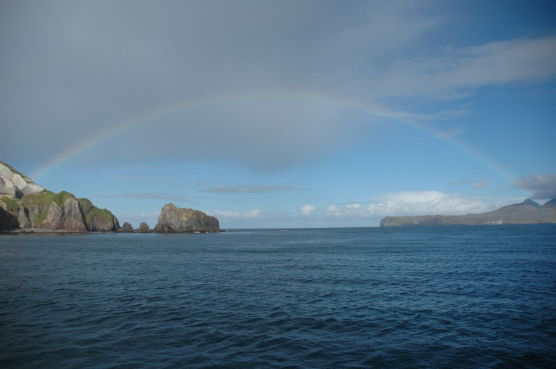
Davidof Volcano and rainbow to Little Sitkin |
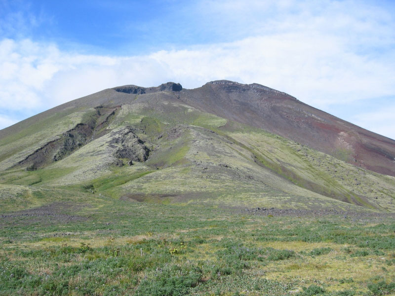
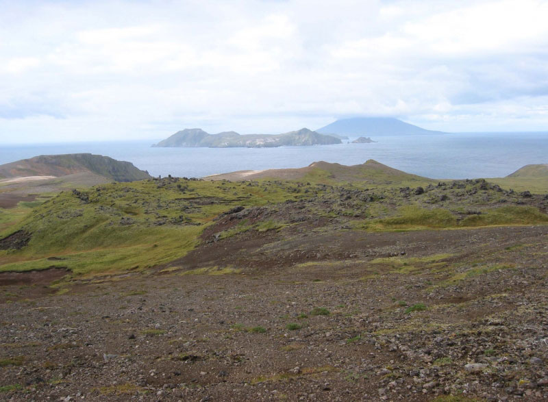
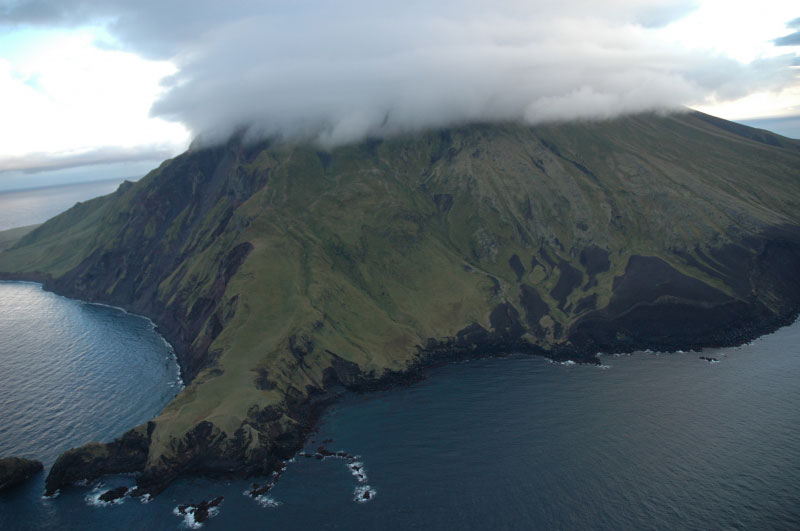
Segula Volcano from the deck of the Maritime Maid. Southwest coastline. Segula Volcano, 1153m, inactive stratovolcano, it has not produced any historical eruptions, while barely eroded deposits on the flanks suggest that activity took place at the volcano as late as a couple of hundred years ago.Built on top of a shallow platform, the volcano grew steadily from eruptions, and is composed of strata of flow deposits and pyroclastic material.Part of the Rat Islands, Segula Volcano is located, along with the other Aleutians, in the Pacific Ocean. Segula Island and the volcano formed over an underwater land surface which hosts other Aleutian volcanoes such as Khvostof and Davidof. Andesitic lava and pyroclastic material was ejected from the underwater crater, building up over time to break the surface from nearly 350 feet (107 m) underwater. Segula is made up of overlapping strata of lava flows and pyroclastic deposits, built up from the caldera. Largely built of eruptive material, the stratovolcano is conical and marked by a fissure. Since it is surrounded by lava flows on the north flank and a cinder cone on the other, the mountain''s caldera, or main crater, appears tiny and is therefore very difficult to make out from any photographs. The north side of the island is summarized by sharp cliffs and a shallow reef which together make accessibility from that side difficult. It has not had a recorded eruption, though numerous deposits of lava flows and other ejecta on the southern and eastern flanks and a submarine deposit to the north of the summit which extends for 11 miles (18 km), make it possible that Segula has erupted in the last few hundred years http://en.wikipedia.org/wiki/Segula_Volcano |
Segula. Iron Point. From Wood and Kienle (1990): "Segula volcano is built upon a 100-m-deep marine platform by the accumulation of flows and pyroclastic material emanating from a single center. Although there are no dated eruptions, some flows and pyroclastic deposits are so little weathered that ages of only a few hundred years are estimated. Pyroclastic material covers much of the cone''s surface and a cinder cone resides in the middle of the summit crater - http://www.avo.alaska.edu/volcanoes/volcinfo.php?volcname=Segula |
Segula Volcano, flank fissure vent southern terminus -http://www.avo.alaska.edu/volcanoes/volcimage.php?volcname=Segula Segula volcano is located in western Aleutian Islands. Lava flows and pyroclastic deposits on the island are little weathered and suggest an eruption withing the past few hundred years |
Segula Volcano, Chugul Point - http://www.avo.alaska.edu/volcanoes/volcimage.php?volcname=Segula |
http://www.avo.alaska.edu/images/image.php?id=3168 |
Kavalga),
http://geopubs.wr.usgs.gov/fact-sheet/fs118-00/ Historically Active Volcanoes in AlaskaŚA Quick Reference
http://www.pbase.com/mjunsworth/aleutian_islands photos Agak
http://xpda.com/aleutians/ photos
http://en.wikipedia.org/wiki/Great_Sitkin_Island
Kiska Island and mix
http://www.mun.ca/serg/semi.html
http://www.melindawebster.com/aleutians2/
http://flickrhivemind.net/Tags/alaska,volcano/Interesting
http://www.sfos.uaf.edu/news/2003/0811volcano.html undersea