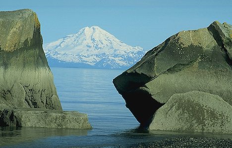
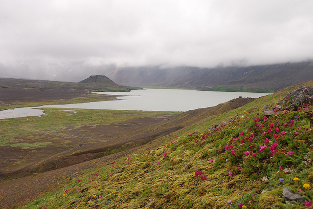
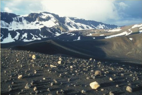
 | Aleutian Range - Aleutian Arc - Edgecumbe/Crater ridge |
An ultra prominent peak, or Ultra for short, is a mountain with a topographic prominence of 1,500 metres |
|
http://en.wikipedia.org/wiki/Fairweather_Fault |
http://en.wikipedia.org/wiki/Aleutian_Arc |
|
|
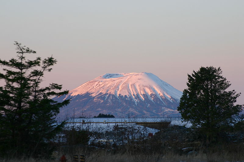
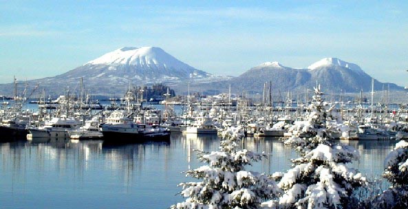
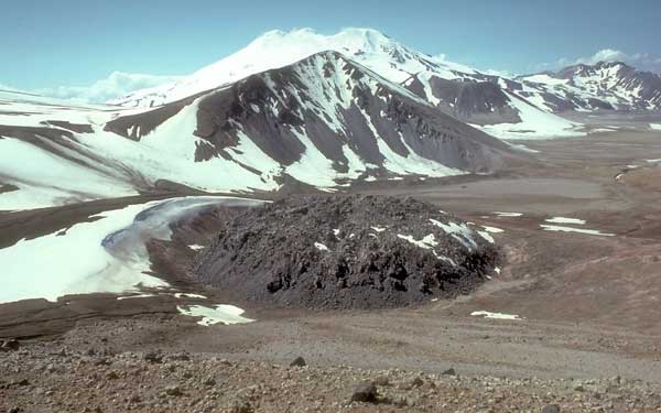
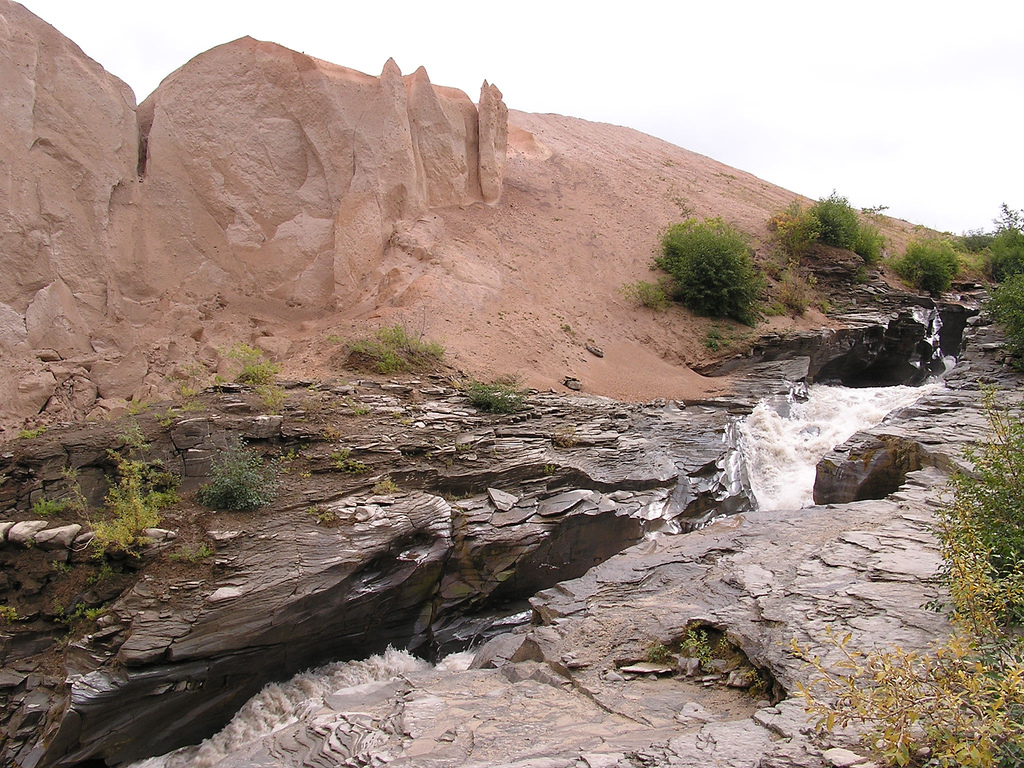
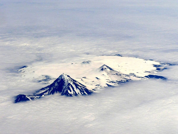
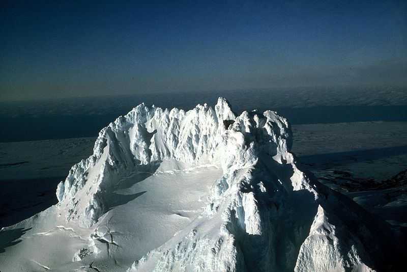
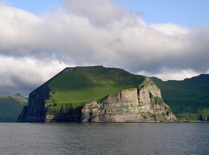
Mount Edgecumbe (Alaska), 976 m, Dacite stratovolcano, age of rocks 600KA, last eruption 2220 BC+/_100, a dormant volcano located at the southern end of Kruzof Island, Alaska, of which it is the highest point. Eruptions 7220 BC, 3810 BC, 2220 BC . False eruption. On April 1, 1974, a local prankster named Oliver Bickar flew in and ignited 100 old tires in the crater, convincing nearby residents of Sitka, Alaska that the volcano was erupting.http://en.wikipedia.org/wiki/Mount_Edgecumbe_(Alaska) |
A snow-capped Mount Edgecumbe, with its companion Crater Ridge, as viewed from nearby Baranof Island |
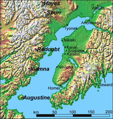
Aleutian Range |
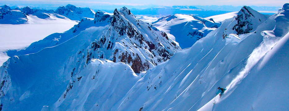
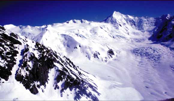
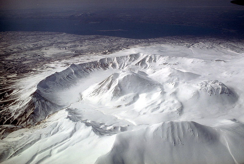
The Tordrillo Mountains complex sits on top of a large granite batholith, surrounded by sedimentary deposits. Some of the peaks are volcanic with large deposits of erosive tephra, which combined with glacial activity, have carved out unrivaled skiing and boarding runs throughout the range. They are heavily glaciated, partly due to their location near Cook Inlet. At the same time, granite bulges with incised couloirs and towers result in runs that never disappoint, ranging from between 1,000 and 1,300 m with great landings and pickup zones that typically offer picture-perfect panoramas of the Alaska Range and Mt. McKinley, the largest peak in North America. 2 volcanoes: Mount Spurr (3,374 m) and Hayes Volcano (2,788 m). Crater Peak (2,309 m) - a subsidiary peak of Mount Spurr |
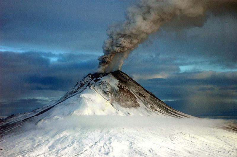
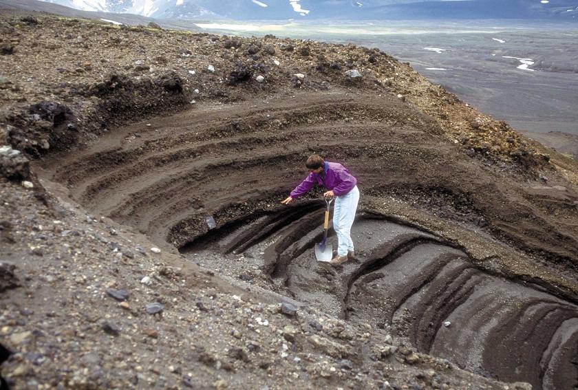
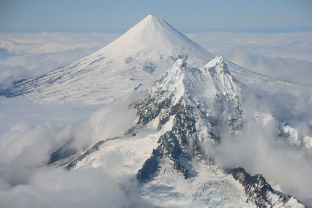
Aerial view of Hayes Volcano in the Tordrillo Mountains near Mount Gerdine (highest peak in background). Most of the volcanic cone of Hayes Volcano was destroyed during the most recent eruption of the volcano, about 3,600 years ago. Because the remaining parts of the cone are obscured by glacier ice and snow, identifying the volcano is difficult. Photograph taken by author T.P. Miller, September 1981. Hayes Volcano is an ice- and snow-mantled, deeply eroded volcanic massif located in the northern Tordrillo Mountains of the north-central Cook Inlet region about 135 kilometers northwest of Anchorage, Alaska. Hayes Volcano consists of a glacially dissected, poorly exposed cluster of lava domes. No historical eruptions of Hayes Volcano are known, and the last period of major eruptive activity occurred within a time interval of 4,400 to 3,600 years ago. During this period, explosive Plinian-style eruptions occurred that dispersed volcanic ash over large areas of interior, south-central, and southeastern Alaska. Pyroclastic flows produced during these eruptions descended Hayes Glacier and entered the Hayes River drainage. The pyroclastic flows initiated volcanic debris flows or lahars that flowed down the Hayes River, into the Skwentna River, and probably reached the Yentna River about 110 kilometers downstream from the volcano. The last major eruptive period of Hayes Volcano may have spanned about 200 years, and at least one of the eruptions during this interval was possibly the largest eruption of any volcano in the Cook Inlet region in the past 10,000 years. The distribution and thickness of volcanic-ash deposits from Hayes Volcano in the Cook Inlet region indicate that volcanic-ash clouds from prehistoric eruptions were voluminous. Clouds of volcanic ash generated during a future eruption of Hayes Volcano would be a major hazard to all aircraft using Ted Stevens Anchorage International Airport and other local airports, and, depending on wind direction, ash clouds could drift a considerable distance beyond the volcano. Ash fallout from future eruptions could disrupt many types of economic and social activities, including oil and gas operations, shipping activities, and power generation in the Cook Inlet area. An eruption of Hayes Volcano-even a minor episode- would likely melt a significant amount of ice and snow, and the meltwater could result in the formation of large lahars and downstream flooding. http://pubs.usgs.gov/of/2002/of02-072/ |
Hayes volcano was discovered in 1975 and named for the adjacent Hayes Glacier. Hayes is almost totally ice-covered. No fumaroles have been observed during site visits in three different years. Little is known of the volcano except that it is the site of catastrophic eruptions that deposited six regional tephra beds to the south, east, and northeast between about 3,500 and 3,800 yr ago. The average volume of each of the six beds is about 2.4 km3. The tephra-forming eruptions may have been accompanied by emplacement of a dome, although no such feature has been positively identified. A thin, poorly preserved tephra bed northeast of the vent may be evidence of late Holocene activity subsequent to the catastrophic eruptionshttp://www.avo.alaska.edu/volcanoes/volcinfo.php?volcname=Hayes |
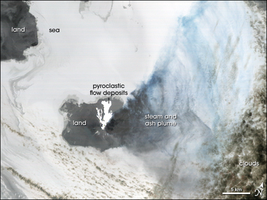
Hayes Volcano. Pyroclastic flows and dome at 2400 m showing the Granite/Quaternary pyroclastic flow contact - http://www.avo.alaska.edu/images/image.php?id=14200 |
Hayes Volcano , 2788 m |
The ring peaks of a huge caldera encircle Mt. Spurr |
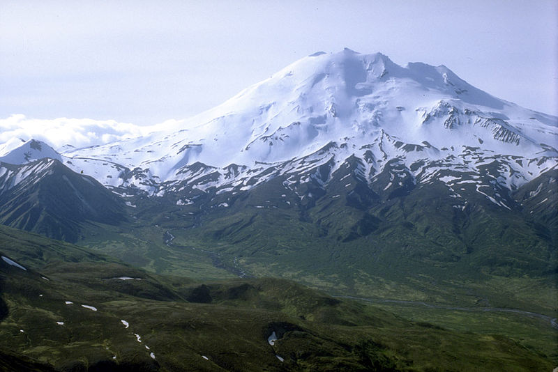
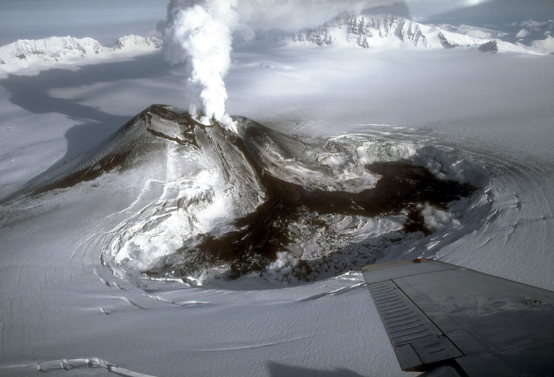
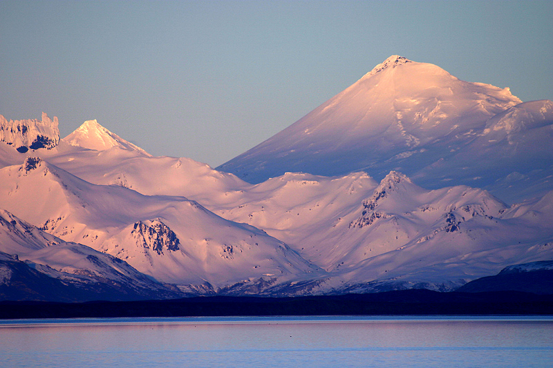
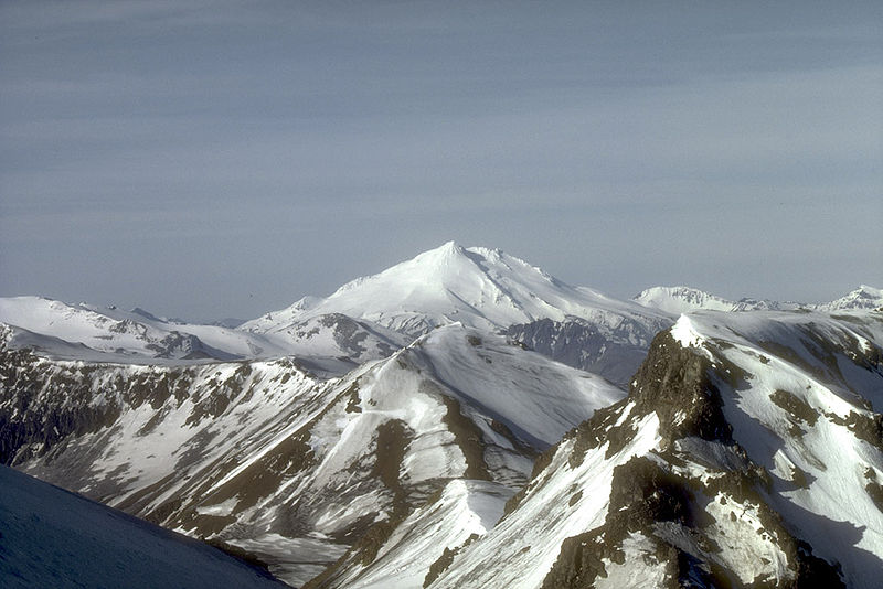
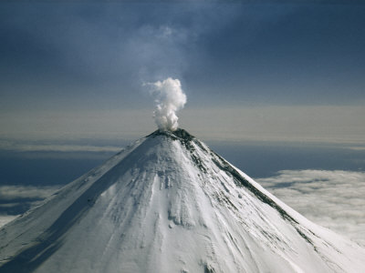
Mount Spurr from the south. Mount Spurr, 3,374 m, Kenai Peninsula Borough, Tordrillo Mountains, Alaska Range , last eruption 1992, age of rocks � 10 000 years, is a stratovolcano in the Aleutian Volcanic Arc of Alaska, Mount Spurr, the highest volcano of the Aleutain arc, is a large lava dome constructed at the center of a roughly 5 km-wide horseshoe-shaped caldera that is open to the south. The volcano lies 130 km west of Anchorage and NE of Chakachamna Lake. The caldera was formed by a late-Pleistocene or early Holocene debris avalanche and associated pyroclastic flows that destroyed an ancestral Spurr volcano. The debris avalanche traveled more than 25 km to the SE, and the resulting deposit contains blocks as large as 100m in diameter. Several ice-carved post-caldera domes lie in the caldera. Present Mt. Spurr is the highest of the post-caldera. This regrown summit peak of Spurr experienced a heating event in 2004 which created a small crater lake. By 2008, the summit crater had cooled enough to have begun to have accumulated significant amounts of snow again. The youngest post-caldera dome, Crater Peak (2309m), formed at the breached southern end of the caldera about 3.2 km south of Spurr, has been the source of about 40 identified Holocene tephra layers. Spurr''s two historical eruptions, from Crater Peak in 1953 and 1992, deposited ash on the city of Anchorage. Crater Peak has a summit crater that is itself slightly breached along the south rim; the north wall of the crater exposes the truncated remains of an older dome or lava lake. Before the 1992 eruption, a small crater lake occupied the bottom of Crater Peak''s crater. As with other Alaskan volcanoes, the proximity of Spurr to major trans-Pacific aviation routes means that an eruption of this volcano can significantly disrupt air travel. Volcanic ash can cause jet engines to fail.Recent activity. On July 26, 2004, the AVO raised the "Color Concern Code" at Spurr from green to yellow due to an increasing number of earthquakes. Earthquakes beneath a volcano may indicate the movement of magma preceding a volcanic eruption, but the earthquakes might also die out without an eruption. In the first week of August 2004, the AVO reported the presence of a collapse pit, filled with water forming a new crater lake, in the ice and snow cover on the summit. This is a third volcano occurred in this pit may have been caused by an increase in heat flow through the summit lava dome.On May 3, 2005, a debris flow was observed in webcam images, as well as by a nearby pilot. A subsequent overflight revealed that much of the sitting pond within the melt hole had drained away, a notable depth- http://en.wikipedia.org/wiki/Mount_Spurr |
ice near the summit of Mount Spurr, seen in this August 2, 2004 Heat emissions created a "melt hole" in the ice near the summit of Mount Spurr, seen in this August 2, 2004 photo. (Chris Waythomas)-http://stevequayle.com/News.alert/05_Cosmic/050201.AK.volcanoes.html |
Mount Spurr |
Mount Spurr |
Mount Spurr |
Mount Spurr |
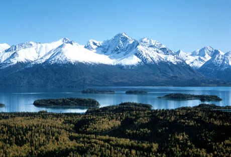
Lake Clark has been called "the essence of Alaska", for it concentrates in a relatively small area of the Alaska Peninsula, Southwest of Anchorage, a variety of features not found together in any of the other Alaska Parks: the junction of three mountain ranges, (the Alaska Range from the North, the Aleutian Range from the South, and the park''s own rugged Chigmit Mountains), two active volcanoes (Iliamna and Redoubt), a coastline with rainforests on the East (similar to South East Alaska), a plateau with tundra on the West (similar to Arctic Alaska), and turquoise lakes - http://en.wikipedia.org/wiki/Lake_Clark_National_Park_and_Preserve. |
Lake Clark National Park -http://en.wikipedia.org/wiki/Lake_Clark_National_Park_and_Preserve |
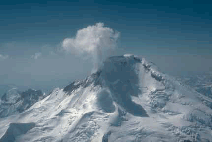
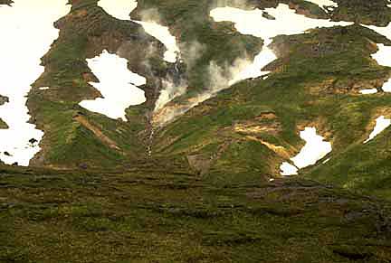
View of the glaciated north flank of Iliamna Volcano. A typical plume of steam and gas rises several hundred meters above the fumarole field. Mount Iliamna, 3,053 m, Lake Clark National Park and Preserve, Chigmit Mountains, Aleutian Range, Aleutian Arc, last eruption 1876(?), is a glacier-covered stratovolcano located approximately 215 km southwest of Anchorage on the west side of lower Cook Inlet. Holocene eruptive activity from Iliamna is little known, but radiocarbon dating seems to indicate at least a few eruptions, all before the European settlement of Alaska. However, fumaroles located at about 2,740 m elevation on the eastern flank produce nearly constant plumes of condensate and minor amounts of sulfurous gases. These plumes are quite vigorous and have resulted in numerous pilot reports and early historical accounts of "eruptions" at Iliamna Volcano -. http://en.wikipedia.org/wiki/Iliamna_Volcano |
Active for millennia, Mount Redoubt has erupted five times since 1900: in 1902, 1922, 1966, 1989 and 2009. http://en.wikipedia.org/wiki/Mount_Redoubt, http://plate-tectonic.narod.ru/volcanoam11ephotoalbum.html |
|
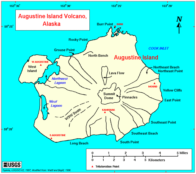
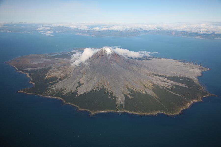
Augustine Volcano, Aleutian arc, 1,260 m, age of rocks more thamn 40 KY, last eruption 2006, is a Lava Dome Complex on Augustine Island in southwestern Cook Inlet in the Kenai Peninsula Borough of southcentral coastal Alaska, 280 kilometers southwest of Anchorage. Augustine Island has a land area of 83.872 km2, while West Island, just off Augustine''s western shores, has 5.142 km2.The island is made up mainly of past eruption deposits. Scientists have been able to discern that past dome collapse has resulted in large avalanches.The nearly circular uninhabited island formed by Augustine Volcano is 12 km wide east-west, 10 km north-south; a nearly symmetrical central summit peaks at altitude 1,260 m - http://en.wikipedia.org/wiki/Augustine_Volcano. |
http://www.photovolcanica.com/VolcanoInfo/Augustine/Augustine.html |
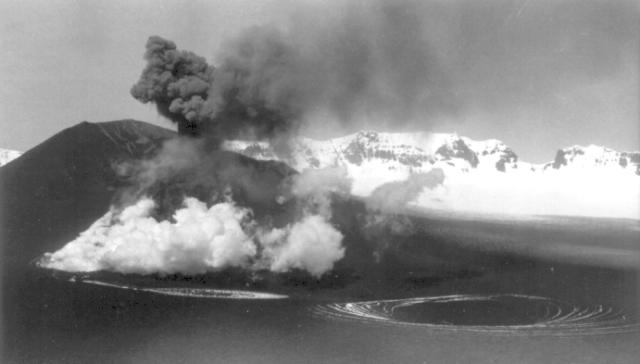
Augustine''s summit consists of several overlapping lava dome complexes placed during many historic and prehistoric eruptions. Most of the fragmental debris exposed along its slopes comprises angular blocks of dome-rock andesite, typically of cobble to boulder size but carrying clasts as large as 4 to 8 m, rarely as large as 30 m. The surface of such deposits is skeet, a field of steep conical mounds and intervening depressions with many meters of local relief. En route to Katmai in 1913, Robert F. Griggs had briefly inferred landslide (debris avalanche) as the origin of Augustine''s hummocky coastal topography about Burr Point, by geomorphic analogy with the hummocky and blocky deposit of a 1912 landslide near Katmai.The hummocky deposits on Augustine''s lower flanks resemble both topographically and lithologically those of the great landslide or debris avalanche that initiated the spectacular May 18, 1980 eruption of Mount St. Helens. The deposit of that landslide revealed the origin of coarse diamicts with hummocky topography at other strato volcanic cones. Since 1980 many hummocky coarsely fragmental deposits on Augustine''s lower flanks have come to be interpreted as deposits of numerous great landslides and debris avalanches. Photo - 2006 eruption http://en.wikipedia.org/wiki/Augustine_Volcano |
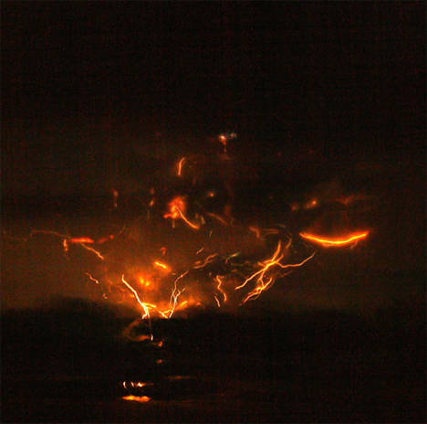
Thermal image after the January 2006 eruptions. White parts of the image are warmer than dark areas.http://en.wikipedia.org/wiki/Augustine_Volcano .A March 27, 1986 eruption deposited ash over Anchorage and disrupted air traffic in southcentral Alaska.On January 11, 1994, Augustine erupted at 13:44 and 14:13 UTC.In mid-December 2005 a sulfur dioxide-laden plume of steam, hundreds of miniature earthquakes and a new coating of ash over its currently snow-clad peak, taken together, suggested that Augustine was building to a new eruption, likely in 2006. The eruption consisted of four "phases", continuing from December to March 2006.The initial stage of the eruption began when microearthquake activity increased steadily from May to December 2005. At first, they started out at around 2 each day to around 15 each day. Microearthquakes are tiny earthquake that suggest a volcanic eruption could possibly occur.The volcano erupted on January 11, entering a second "stage", which would continue until January 28. Tectonic earthquakes began early on January, resulting in an explosive Volcanic Explosivity Index 3 eruption later in the day. Several ash columns were generated, each 9 km above sea level; these plumes were steadily influenced to the north and northeast of the volcano. Samples of the tephra were dense, insinuating that the lava released was mature.Six explosions were recorded by seismic instruments between January 13, the first of these consuming a seismograph and a CPGS located on the northwestern flank. Ash columns now reached 14 km and Kenai Peninsula residents reported ash deposits. On January 16, a new lava dome was observed on the summit; and the next day another explosive eruption sent ash 13 km into the atmosphere. This explosion created a 20-30 meter wide crater in the new lava dome.On September 22, 2007, the Alaska Volcano Observatory reported that shallow earthquake activity had increased over the week of September 22. However, the activity was less than its level during the months leading up to the 2005-2006 eruption.The Plate Boundary Observatory, operated by UNAVCO has a network of 10 high-precision GPS instruments on the flanks of Augustine. Activity two years ago claimed two of these sites. The Alaska Volcano Observatory also operates a number of seismometers and tiltmeters all around the volcano, including four webcams http://en.wikipedia.org/wiki/Augustine_Volcano |
Alaska Peninsula -http://en.wikipedia.org/wiki/Aleutian_Range |
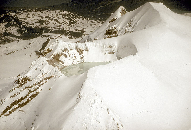
Crater lake at the summit, June 1990. Mount Douglas, 2,140 m, Katmai National Park and Preserve, Aleutian Range, Aleutian Range, Aleutian Arc, is a stratovolcano located south of Kamishak Bay, near the northeasternmost part of the Alaska Peninsula. It lies in the Katmai National Park and Preserve in Kenai Peninsula Borough.The volcano has a warm and highly acidic crater lake approximately 160 m wide. In 1992, the lake had a temperature of 21�C and a pH of 1.1. At the north flank of the volcano unglaciated and relatively uneroded lava flows are found. The last eruption was considered to have occurred during the Holocene (Nye et al.,1998) -. http://en.wikipedia.org/wiki/Mount_Douglas_(Alaska) |
http://vallescaldera.com/archives/1419 |
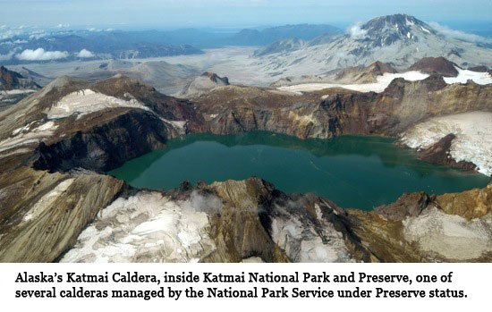
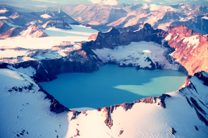
Katmai Crater . http://en.wikipedia.org/wiki/Mount_Katmai |
|
Novarupta |
Novarupta lava dome in July 1987 |
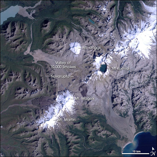
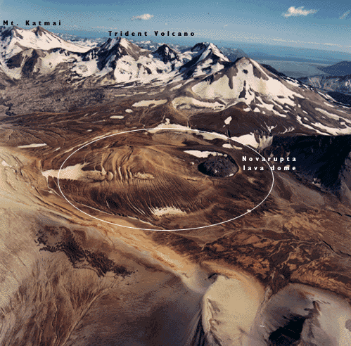
Novarupta volcano, Novarupta, meaning "new eruption", is a new volcano that was created in 1912 and located on the Alaska Peninsula in Katmai National Park and Preserve, about 470 km southwest of Anchorage. Formed in 1912 during the largest volcanic eruption of the 20th century, Novarupta released 30 times the volume of magma as the 1980 eruption of Mount St. Helens. 841 m, Aleutian Range, caldera, last eruption 1912. http://en.wikipedia.org/wiki/Novarupta |
Colorful ash in the Valley of Ten Thousand Smokes |
Katmai lava flow |
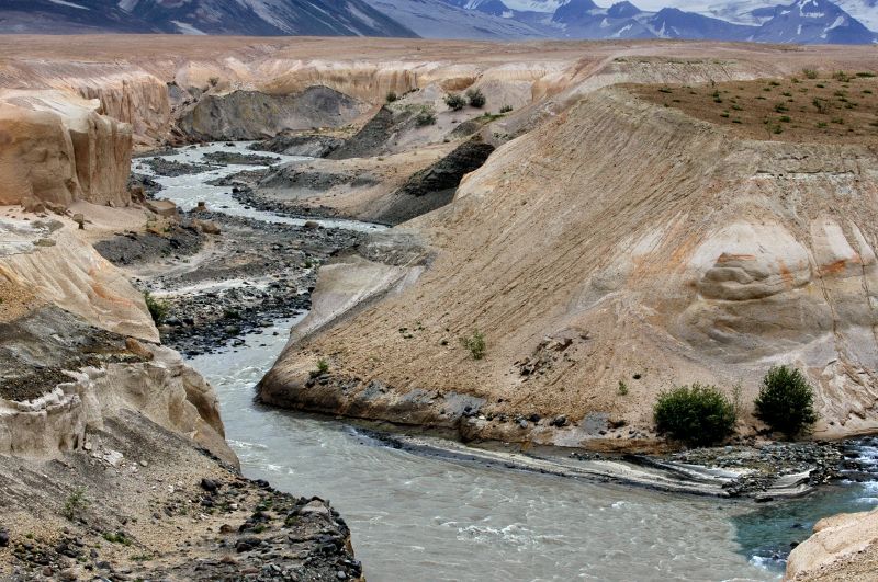
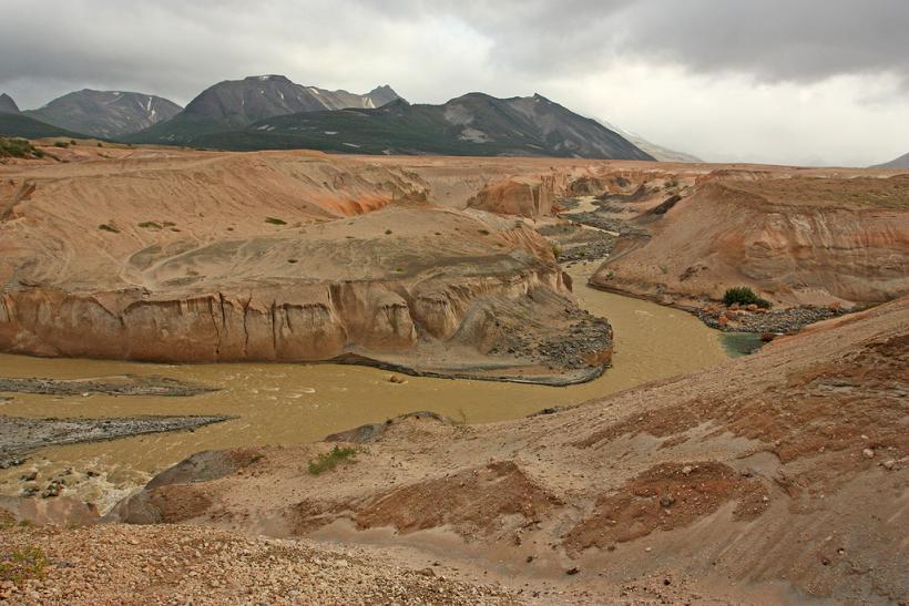
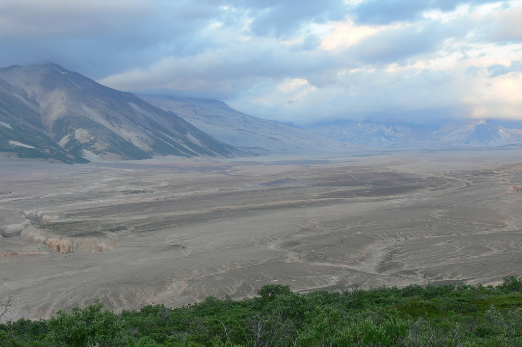
The Valley of Ten Thousand Smokes is a valley within Katmai National Park and Preserve in Alaska which is filled with ash flow from the eruption of Novarupta on June 6�June 8, 1912. Following the eruption, thousands of fumaroles vented steam from the ash. Robert F. Griggs, who explored the volcano�s aftermath for the National Geographic Society in 1916, gave the valley its name, saying that �the whole valley as far as the eye could reach was full of hundreds, no thousands�literally, tens of thousands�of smokes curling up from its fissured floor.�The 1912 eruption was the largest eruption by volume in the 20th century, erupting about 13 km3 of material. Novarupta generated as many as 14 major earthquakes with magnitudes between M6 and M7, a level of energy release virtually unprecedented during volcanic eruptions in modern memory, and over 100 earthquakes greater than M5. Following the eruption, the summit of Mount Katmai subsided (collapsed) about 1,200 m forming the central caldera. Katmai is a stratovolcano, formed from alternating layers of lava flows and pyroclastic rocks. The presence of pyroclastic materials indicates that some Katmai eruptions have been explosive. The subsidence of the summit to form the central caldera and the extraordinarily energetic earthquakes accompanying the 1912 eruption are evidence of this The ash-filled valley covers a 100 km2 area and is up to 210 m deep. In places deep canyons have been cut by the River Lethe, allowing observers to see the ash flow strata. Since the ash has cooled, most of the fumaroles are now extinct and despite its name the valley is no longer filled with smoke. The signs of volcanic activity are still visible on nearby hills. Katmai�s most recent eruption was in 1927, but there have been non-eruptive events as recent as 2003. The Alaska Volcano Observatory still monitors Katmai�s activity as part of the Katmai Cluster, where there are 5 active stratovolcanos within 15 km of Katmai. http://www.phenomenica.com/2009/08/valley-of-ten-thousand-smokes.html |
River eroding volcanic ash flow, Valley of Ten Thousand Smokes |
The Valley of Ten Thousand Smokes |
|
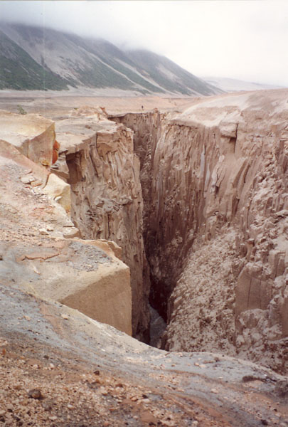
Knife Creek Gorge. The Valley of Ten Thousand Smokes is a valley within Katmai National Park and Preserve in Alaska which is filled with ash flow from the eruption of Novarupta on June 6�8, 1912. Following the eruption, thousands of fumaroles vented steam from the ash. Robert F. Griggs, who explored the volcano''s aftermath for the National Geographic Society in 1916, gave the valley its name, saying that "the whole valley as far as the eye could reach was full of hundreds, no thousands�literally, tens of thousands�of smokes curling up from its fissured floor."The 1912 eruption was the largest eruption by volume in the 20th century, erupting about 13 km3 of material. Novarupta generated as many as 14 major earthquakes with magnitudes between M6 and M7, a level of energy release virtually unprecedented during volcanic eruptions in modern memory, and over 100 earthquakes greater than M5. Following the eruption, the summit of Mount Katmai subsided (collapsed) about 1,200 meters (3,900 ft), forming the central caldera. Katmai is a stratovolcano, formed from alternating layers of lava flows and pyroclastic rocks. The presence of pyroclastic materials indicates that some Katmai eruptions have been explosive. The subsidence of the summit to form the central caldera and the extraordinarily energetic earthquakes accompanying the 1912 eruption are evidence of this.The ash-filled valley covers a 100 km2 area and is up to 210 m deep. In places deep canyons have been cut by the River Lethe, allowing observers to see the ash flow strata. Since the ash has cooled, most of the fumaroles are now extinct and despite its name the valley is no longer filled with smoke. The signs of volcanic activity are still visible on nearby hills. Katmai''s most recent eruption was in 1927, but there have been non-eruptive events as recent as 2003. The Alaska Volcano Observatory still monitors Katmai''s activity as part of the Katmai Cluster, where there are 5 active stratovolcanos within 15 km of Katmai.http://en.wikipedia.org/wiki/Valley_of_Ten_Thousand_Smokes |
The Valley of Ten Thousand Smokes |
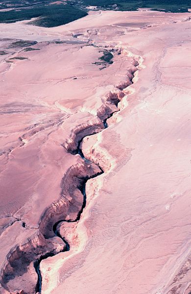
The Valley of Ten Thousand Smokes. Canyon cut in ash by River Lethe |
The Valley of Ten Thousand Smokes |
Katmai National Park |
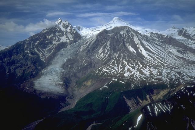
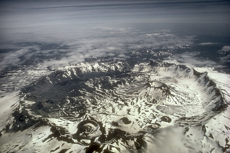
Katmai National Park, Alaska. The great 1912 eruption of Novarupta Volcano covered the flanks of Katmai Volcano with thick ash falls still visible in this photo taken from a light plane 51 years later. The summit of Katmai collapsed into a caldera (off to the right side) as magma was removed from beneath the peak. Trident volcano (center) was erupting a lava dome and andesite flow. |
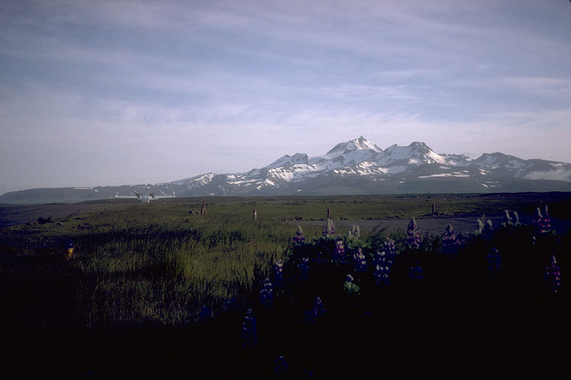
Trident Volcano, Katmai National Park, last eruption 1975 ,1,864 m, is an eroded stratovolcanic complex consisting of domes up to 23 domes, along a northeast-southwest oriented volcanic front on the Pacific Ocean side of the Alaska Peninsula. A new dome was emplaced beginning in 1953 at an altitude 1,097 m in an amphitheater on the southwest flank of the southwest peak.There is no evidence of recent eruptive activity at the summit of Trident, nor have there been any reports of historical activity, except fumarolic activity on the east side. The earliest known activity were minor eruptions in 1913, 1949 and 1950. A satellite cone formed February 15, 1953 on the southwest flank of Trident following a major explosive eruption that sent ash to an altitude of over 9.0 km. A succession of blocky lava flows were erupted in 1954, 1957, 1958, 1959-1960 from the new vent. Ash eruptions, some to altitudes over 12 km, were associated with several of the lava eruptions. By 1960, the dome had grown nearly 260 m high and a sequence of viscous flows, up to 300 m thick and covering an area of about 5 km2 south of the volcano, had been extruded. Further explosions were reported in the early to late 1960s. Lava extrusion, accompanied by explosions were also reported from 1966 to 1968 and 1974 to 1975. In 1983, steam and/or vapor continued to rise from the central vent area of the new cone as well as from numerous fumaroles on the near-vent portion of the blocky lava flows.Trident lavas are andesitic to dacitic in composition. The dominant phenocrysts are zoned plagioclase, hypersthene, calcic clinopyroxene, titanomagnetite, and rimmed olivine. The five flows which erupted from the new vent during the period from 1953 to 1963 are olivine-bearing, two pyroxene, high-silica andesite.- http://en.wikipedia.org/wiki/Trident_Volcano |
Mount Mageik (left) and Mount Martin (right). Mount Mageik, Katmai National Park, 2,165 m, is Pleistocene to Holocene a stratovolcano on the Alaska Peninsula. It has no confirmed historical eruptions (one in 1946 is now deemed questionable), but its youngest eruptive products are apparently Holocene in age. A young crater lies on the northeast flank of the central summit cone, and is the site of vigorous superheated fumarolic activity with prominent sulfur deposits.The volcano is mantled in ash from the 1912 eruption of Novarupta and from the 1953 eruption of nearby Trident Volcano. http://en.wikipedia.org/wiki/Mount_Mageik |
Summit crater of Mount Martin volcano, June 1990. Mount Martin, 1,863 m, is a stratovolcano, located on the Alaska Peninsula, Katmai National Park . Last eruption 1953. It is one of the volcanoes in the vicinity of the Valley of Ten Thousand Smokes. Although an eruption in 1953 is now considered questionable and no other confirmed eruptive activity has taken place at Mount Martin, there is intense fumarolic activity within its summit crater. The summit crater is also breached to the southeast. The 300 m -wide summit crater is often ice-free due to the geothermal heat and contains an intermittent acidic crater lake. The fumaroles in the summit crater produce extensive sulfur deposits.The volcano is named for George C. Martin, who was the first person to visit the Valley of Ten Thousand Smokes after the 1912 eruption of Novarupta. http://en.wikipedia.org/wiki/Mount_Martin_(Alaska) |
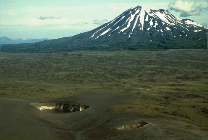
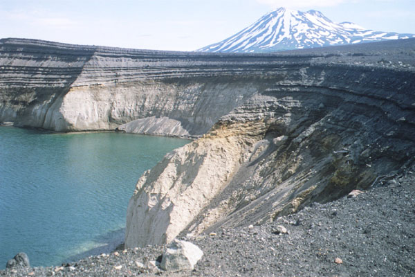
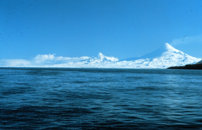
Peulik Volcano and Ukinrek Maars |
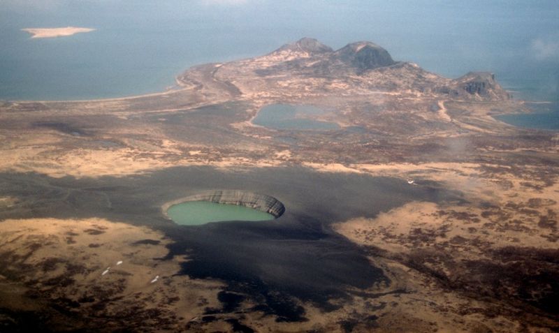
Alaska Peninsula, Peulik Volcano and Ukinrek Maars -http://en.wikipedia.org/wiki/Aleutian_Range. Ukinrek volcano, maar, summit elevation 91 m is located 1.5 km south of Lake Becharof. The volcano consists of two lake-filled explosion craters. West Maar is 105 x 170 m wide and 35 m deep. The second maar, 600 m east, is 300 m wide and 70 m deep. Eruption 1977. |
From Miller and others (1998): "Ukinrek Maars are a pair of phreatomagmatic explosion vents that formed on a low (less than 100 m high), 4-km-long, ridge in the Bering Sea Lowland 1.5 km south of Becharof Lake and 12 km northwest of Peulik Volcano. West Maar, elliptical in shape and up to 170 m in diameter and 35 m deep, formed on the northwest end of the ridge (Kienle and others, 1980). East Maar lies 600 m east of West Maar at a lower elevation. It is circular, up to 300 m in diameter and 70 m deep, and has a 49-m-high central lava dome that is now partly covered by a crater lake. Location of the maars apparently coincides with, and may be controlled by, the intersection of the Bruin Bay fault and regional structures (Kienle and others, 1980; Detterman and others, 1983)."http://en.wikipedia.org/wiki/Ukinrek_Maars |
Aerial view, looking southwest, of Ugashik caldera adjacent to Peulik volcano.Ugashik-Peulik , 1,474 m, Lake and Peninsula Borough, is a stratovolcano in the U.S. state of Alaska. It is located to the south of Becharof Lake in Lake and Peninsula Borough on the Alaska Peninsula. It is part of the Aleutian Range. Its last eruption was in 1814 http://en.wikipedia.org/wiki/Ugashik-Peulik |
Chiginagak Volcano, Alaska Peninsula National Wildlife Refuge, Lake and Peninsula Borough, Alaska, 2221 m, last eruption 1998, is a stratovolcano in the Aleutian Islands, located about 15 km NW of Chiginagak Bay An unglaciated lava flow and an overlying pyroclastic-flow deposit extending east from the summit are the most recent products of Chiginagak. They most likely originated from a lava dome at 1687m on the SE flank, 1 km from the summit of the volcano. Brief ash eruptions were reported in July 1971 and August 1998. Fumarolic activity occurs at 1600m elevation on the NE flank of the volcano, and two areas of hot-spring travertine deposition are located at the NW base of the volcano near Volcano Creek.A 400m wide and 105m deep acidified summit crater lake at Chiginagak formed after November 2004 and before May 2005. In early May 2005, a catastrophic release of acidic water from the lake, with an accompanying acidic aerosol component, drained and flooded Indecision and Volcano Creeks with acidic water, traveled 27 km downstream and flowed into the Mother Goose Lake, headwaters of the King Salmon River. Extensive vegetation damage occurred along the flood route and Mother Goose Lake was acidified (pH of 2.9-3.1), killing all aquatic life and preventing the annual salmon run. The lake now drains from the summit through an outlet cave into Indecision Creek. Indecision Creek now usually has a strong sulphur odar, yellowish color and a pH of 1.2. http://en.wikipedia.org/wiki/Mount_Chiginagak |
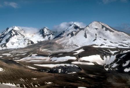
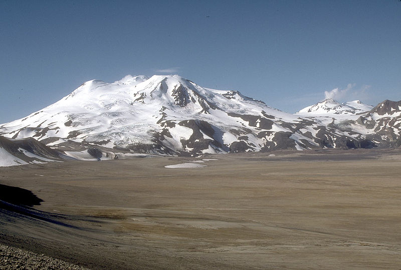
Mount Aniakchak , 1341 m, Aniakchak National Monument and Preserve, Alaska, last eruption 1931, is a 3,700 year old volcanic caldera (about 10 km in diameter) located in the Aleutian Range of Alaska, United States. The area around the volcano is the Aniakchak National Monument and Preserve, maintained by the National Park Service. In November 1967, Aniakchak Caldera was designated as a National Natural Landmark by the National Park Service. Aniakchak caldera formed during a major eruption of VEI=6, which left evidence in ice cores dated to 1645 BC.After the caldera forming events, from about 3500 years ago to the present, more than 20 eruptions occurred from vents on the caldera floor. Vent Mountain has been the source of numerous eruptions of ash, bombs, and lava flows since the formation of the caldera. From 1500 BCE to 1000 CE four lava domes were extruded on the caldera floor. Textural evidence indicates that these lava-dome eruptions occurred beneath Ancient Surprise Lake which was as deep as 100m. Ancient Surprise Lake drained catastrophically before about 1000 CE. (Surprise Lake is now about 2.75 km2 in area and up to 19.5 m deep.) Prior to or immediately after this draining, explosive eruptions of andesitic magma produced a cluster of three tuff cones in the southeastern part of the caldera.Around 1500 CE, during one of the most violent events in recent history at Aniakchak, an estimated 0.75 to 1.0 km3 of material destroyed a preexisting edifice at Half Cone and inundated most of the caldera floor with pyroclastic flows, surges, and fallout many meters thick. During the final phase of this eruption, a lava flow filled the basin formed during the collapse of Half Cone.Several more recent prehistoric eruptions occurred in the summit crater and along the south flank of Vent Mountain producing a field of blocky dacite lava flows against the south wall of the caldera. Minor eruptions immediately west and east of Vent Mountain produced a small scoria cone (Blocky Cone) and two maar craters (now water-filled) along the base of the southeast caldera wall.European-descended geologists discovered the volcano in 1922.The volcano''s only eruption in historical time was that of 1931. The Jesuit priest Father Bernard Hubbard recorded it. "A small but impressive explosion pit was added to the pockmarked caldera floor that year. Many thousands of tons of ash lay strewn within the caldera and scattered up to 40 miles away over the small villages http://en.wikipedia.org/wiki/Mount_Aniakchak Aniakchak crater, with active parasitic vent |
Aniakchak caldera |
Aniakchak caldera |
Iron ore springs in Surprise Lake in Mount Aniakchak caldera in Alaska-http://www.public-domain-photos.org/surprise-lake-in-mount-aniakchak-caldera.html |
Aniakchak volcano rose to a height of 2 300 . until an eruption 3,500 years ago caused it to collapse in on itself. The result was a massive caldera 6 miles across and completely enclosed. The caldera filled with water over time forming a lake similar to Oregon�s Crater Lake. About 2,000 years ago, the crater rim collapsed and the water escaped through the V-shaped notch now known as The Gates. Surprise Lake is all that is left of this once huge lake. The caldera became an oasis of rich plant and animal life that early explorers described as a paradise. In 1931, Vent Mountain erupted in a cataclysmic blast that destroyed all plant and animal life within the caldera. The lake turned black, molten lava covered the floor of the caldera, sulfur fumes filled the air and the ground for miles around was covered with thick volcanic ash. Paradise had turned to hell. The caldera is slowly returning to normal. Lichens, grasses and flowering plants have begun to grow in the rich volcanic ash and birds and mammals have followed - http://www.amrguides.com/river/aniakchak/aniakchak.html |
Aniakchak volcano rose to a height of 2 300 . until an eruption 3,500 years ago caused it to collapse in on itself. The result was a massive caldera 6 miles across and completely enclosed. The caldera filled with water over time forming a lake similar to Oregon�s Crater Lake. About 2,000 years ago, the crater rim collapsed and the water escaped through the V-shaped notch now known as The Gates. Surprise Lake is all that is left of this once huge lake. The caldera became an oasis of rich plant and animal life that early explorers described as a paradise. In 1931, Vent Mountain erupted in a cataclysmic blast that destroyed all plant and animal life within the caldera. The lake turned black, molten lava covered the floor of the caldera, sulfur fumes filled the air and the ground for miles around was covered with thick volcanic ash. Paradise had turned to hell. The caldera is slowly returning to normal. Lichens, grasses and flowering plants have begun to grow in the rich volcanic ash and birds and mammals have followed - http://www.amrguides.com/river/aniakchak/aniakchak.html |
the Gates of Aniakchak Caldera |
Aniakchak Caldera |
Sampling volcanic pyroclastic deposits at Aniakchak caldera, Halft Cone Deposits |
Mount Veniaminof, 2,507 m, Alaska Peninsula National Wildlife Refuge, Alaska, is an active stratovolcano with the summit caldera. The volcano was the site of a colossal (VEI 6) eruption around 1750 BC. This eruption left a large caldera. In modern times the volcano has had numerous small eruptions (over ten of them since 1930); these are located at a cinder cone in the middle of the caldera.Veniaminof has one of the highest elevations of Alaskan volcanoes. Partly for this reason, it is covered by a glacier that fills most of the caldera. Because of the glacier and the caldera walls, there is the possibility of a major flood from a future glacier run . Last eruption February 22, 2008. http://en.wikipedia.org/wiki/Mount_Veniaminof |
Photograph of Veniaminof from the SW, on 9 June 1983 between 1515 and 1600. The circular collapse depression is shown in right foreground, the meltwater pond to its left. Steam emerges from the hole melted by the lava flow in the ice at the base of the cone. Ash is being ejected from the active cone. The caldera ice is covered by a thin layer of ash. The snow-covered caldera rim is visible in the background, with the notch at right leading to Crab Glacier (figure 2). The steaming ice pit, shown on figure 2 and described above, formed after this photo was taken. Courtesy of USGS http://www.volcano.si.edu/world/volcano.cfm?vnum=1102-07-&volpage=var |
Pavlof Volcano, 2,519 m, is a stratovolcano of the Aleutian Range on the Alaska Peninsula. It has been one of the most active in the United States since 1980, with eruptions recorded in 1980, 1981, 1983, 1986�1988, 1996�1997, and an ongoing eruption starting on August 15, 2007 and ending on September 13. The Alaska Volcano Observatory currently rates Pavlof as Aviation Color Code Green and Volcano Alert Level Normal. With a threat score of 95, the threat from future eruptions is considered to be high; much of this threat comes from the possibility of disruption of nearby air routes by large releases of ash. The mountain shares a name with the nearby Pavlof Sister, which last erupted in 1786.Last eruption - August 15, 2007 - September 13, 2007The main challenge of climbing this peak is its remoteness and the consequent difficulty of access. The peak is a 30 mi (48 km) journey from the north side of Cold Bay. The climb itself is a straightforward snow climb, and the ski descent is recommended.Since its last eruption in 1996, the volcano entered a period of dormancy, the longest it has ever been dormant since records of its eruptions have been kept. This period ended on August 15, 2007, with the start of a new eruption involving seismic disturbances and a "vigorous eruption of lava." Scientists said that the volcano "could be working toward a massive eruption that could affect air travel but was not expected to threaten any of the towns in the area." The eruption ended on September 13, but activity may resume soon. http://en.wikipedia.org/wiki/Mount_Pavlof |
Pavlof Volcano |
Pavlov Sister, 2,142 m is a stratovolcano on the Alaska Peninsula. It is a satellite peak of Mount Pavlof, lying directly northeast http://en.wikipedia.org/wiki/Pavlof_Sister |
Cold Bay volcano, a stratovolcano at the southwest end of the Alaska Peninsula. Cold Bay Volcano is a 1,920 m stratovolcano at the southwest end of the Alaska Peninsula in the U.S. state of Alaska - http://en.wikipedia.org/wiki/Cold_Bay_Volcano |
Mount Dutton, 1,506 m is a stratovolcano in the Aleutian Range of the U.S. state of Alaska, on the Alaska Peninsula Dutton is a highly glaciated volcano. Its summit is composed of a series of lava domes which form a complex stratovolcano. The mountain''s recent history is marked by at least avalanche which removed andesitic lava flows and several lava domes from the flank of its body and swiftly cascaded westward and southward towards Belkofski Bay.Between 1984 and 1985, a series of earthquake swarms took place in the volcano''s vicinity. Another swarm took http://en.wikipedia.org/wiki/Mount_Dutton |
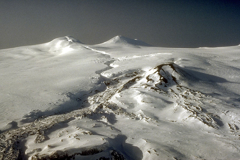
Westdahl Peak, including nearby Faris Peak and Pogromni volcano .From Miller and others (1998): "Westdahl Peak, including nearby Faris Peak and Pogromni volcano, is located on a gently sloping plateau (mean elevation 1220 m) that may represent the surface of a truncated ancestral cone. Westdahl Peak is about 18 km in diameter at the base. The size of the postulated ancestral cone is about 19 x 30 km at sea level, making it one of the largest volcanoes in the Aleutian Islands be it a stratovolcano or a shield. The entire ancestral cone has been extensively dissected by erosion, with the northeast-facing slopes steeper and of greater relief than the other slopes.Based on the degree of erosional dissection, most of the postulated stratovolcano must have formed before early post-glacial time. Pogromni Volcano is moderately dissected and has broad valleys that have probably been glacially eroded. Such glacial erosion could have occurred during neoglaciation beginning about 3000 years ago (Black, 1974, although one or two thousand years seem inadequate to account for the degree of dissection. Pogromni volcano was probably active by latest Pleistocene time, which implies that truncation of the ancestral stratovolcano must have occurred earlier." -http://www.avo.alaska.edu/volcanoes/volcinfo.php?volcname=Westdahl |
Summit area of Westdahl volcano, February 1993. Mount Westdahl, 1,654 m, last eruption 1992, is a stratovolcano in the U.S. state of Alaska. It is located on Unimak Island, near the western tip of the Alaska Peninsula, in the Aleutian Range -http://en.wikipedia.org/wiki/Mount_Westdahl |
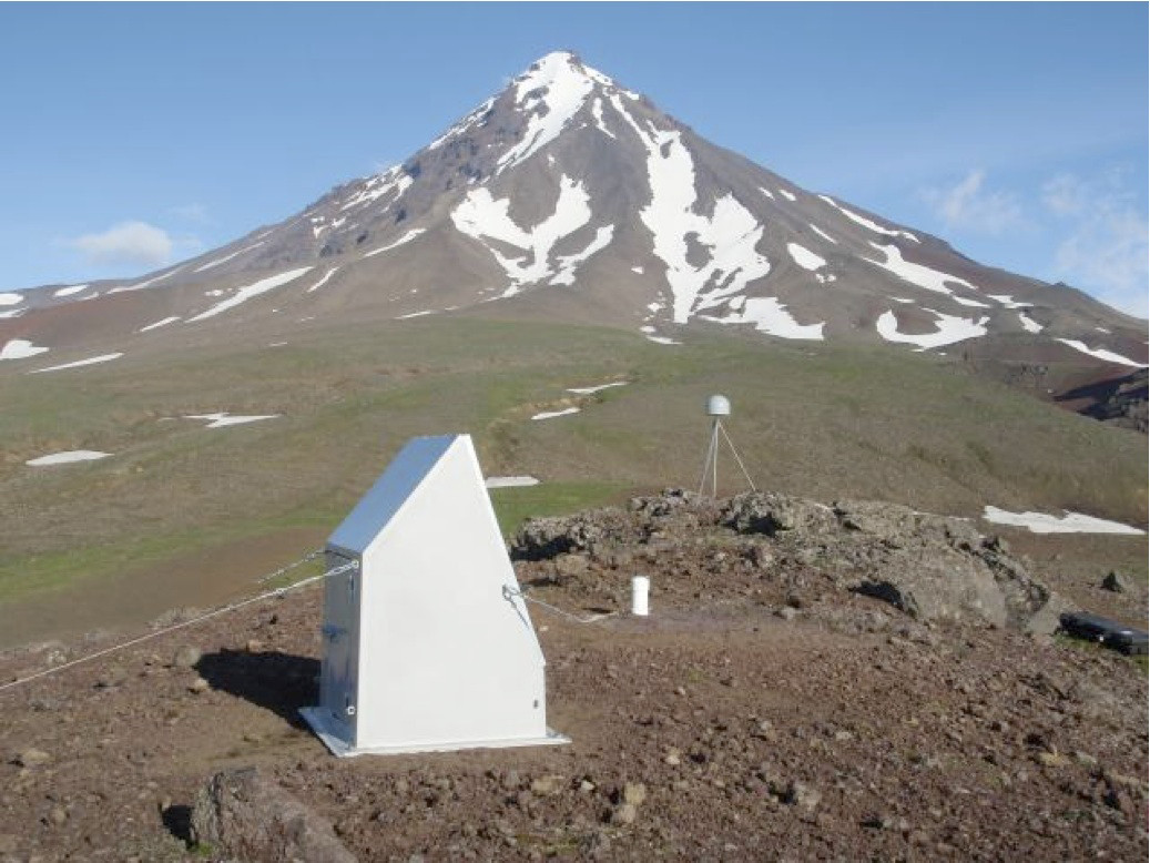
Plate Boundary Observatory GPS Station on Westdahl Volcano, Alaska |
Isanotski volcano as viewed from Cold Bay, near Grant Point. http://www.avo.alaska.edu/images/image.php?id=16779 |
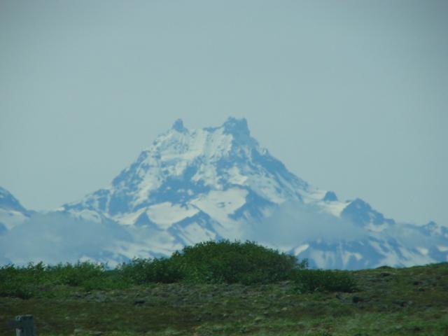
Isanotski Peaks or Isanotski Volcano, 2,471 m, known locally as "Ragged Jack", is a multipeaked mountain on Unimak Island, the easternmost Aleutian Island in Alaska, United States. It is an old, highly dissected stratovolcano, lying about 16 km east of Shishaldin Volcano, the highest peak in the Aleutian Islands. Its height is also often given as 2446 m.In contrast to many of the younger, symmetrical volcanoes of the region, Isanotski is topped by multiple rugged pinnacles. This makes climbing or skiing the peak much more challenging than Shishaldin, for example |
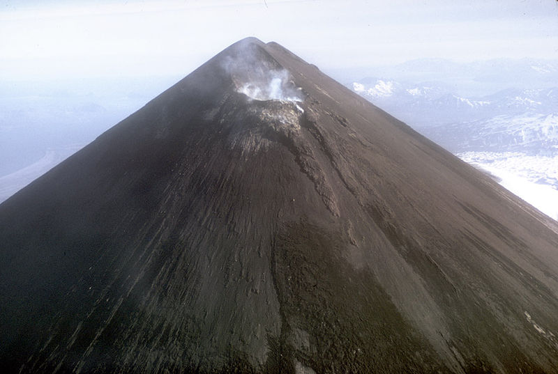
Shishaldin and Isanotski. Mount Shishaldin, Aleutian Range, Volcanic arc/belt Aleutian Arc, last eruption 2004, is a moderately active stratovolcano on Unimak Island in the Aleutian Islands chain of Alaska. It is the highest mountain peak of the Aleutian Islands. The most symmetrical cone-shaped glacier-clad large mountain on earth, the volcano''s topographic contour lines is nearly perfect circles above 2,000 m. The lower north and south slopes are somewhat steeper than the lower eastern and western slopes. The volcano is the westernmost of three large stratovolcanoes along an east�west line in the eastern half of Unimak Island. The Aleuts named the volcano Sisquk, meaning "mountain which points the way when I am lost." The upper 2,000 m is almost entirely covered by glacial snow and ice. In all, Shishaldin''s glacial shield covers about 91 km2. It is flanked to the northwest by 24 monogenetic parasitic cones, an area blanketed by massive a lava flows. The Shishaldin cone is less than 10,000 years old and is constructed on a glacially eroded remnant of an ancestral soma and shield. Remnants of the older ancestral volcano are exposed on the west and northeast sides at 1,500�1,800 m elevation. The Shishaldin edifice contains about 300 km3 of material. A very steady steam plume rises from its small summit crater which is about 150 m across and slightly breached along the north rim.This volcano has had many recorded eruptions during the 19th and 20th centuries, and a couple reports of volcanic activity in the area during the 18th century may have referred to Shishaldin as well. Therefore the volcano''s entire recorded history is spotted with reports of activity.Mount Shishaldin''s most recent eruptions were in 1995�96 and 1999. Since the 1999 eruption, it has maintained seismic activity, typically having very low-magnitude volcanic earthquakes (most are below magnitude 1) every 1�2 minutes. During this period of non-eruptive seismic activity, it has been puffing steam, with puffs also occurring about every 1�2 minutes. There were reports in 2004 of small quantities of ash being emitted with the steam.The first recorded ascent of Shishaldin was in 1932, by G. Peterson and two companions. Given the straightforward nature of the climbing (Alaska Grade 1, snow up to 40 degree slope), it is possible that an earlier ascent occurred, either by native Aleuts, Russians, or other visitors. Shishaldin is a popular ski descent (6,000 feet/1,830 m vertical) for local climbers (of whom there are few). Due to its remoteness Shishaldin is not often climbed by outsiders http://en.wikipedia.org/wiki/Mount_Shishaldin |
Shishaldin |
Shishaldin |
The Shishaldin Volcano is not very explosive, possessing basaltic lava, which is extremely dense. When erupting, the volcano can spew ash 20 kilometers into the air, making any air traffic potentially lethal. Ash clouds can destroy plane engines and other electronics, and ash clouds can drift and affect other, further, nations. Eruptions can also melt polar icecaps, causing massive flooding, as well as lahars, which are mudslides made of volcanic fragments. Pyroclastic flows are also common. They are strong and incredibly hot surges of semi solid material and they destroy everything in their path. Lava flows are also common - http://shishaldinvolcano.blogspot.com/ |
Shishaldin and Isanotski. |
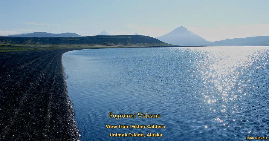
Just south of the southeastern caldera rim looking west across the southern caldera wall of Fisher volcano. AVO scientist Dr. Jim Gardner investigates an older basaltic lava flow. The low area on the right is the southern caldera floor, and the snow-free peak on the right is one of the stratocones partially destroyed in the caldera-forming eruption 9,400 years ago. The snow covered peaks in the background are Westdahl (left) and Faris Peak - http://www.avo.alaska.edu/images/image.php?id=24743 |
Fisher caldera is located on western end of Unimak Island, Alaska. It is the largest of 12 Holocene calderas in the Aleutian volcanic arc, with a diameter of 18 km x 11 km. summit elevation 1094 m. stratovolcano. Fisher volcano is located in a region of high convergence rate between the Pacific and North American plates. This correlates with the region of greatest volcanic activity. In contrast to nearby volcanoes, Fisher has shown little historic activity.Eruptions at Fisher volcano can be divided into three periods - Pleistocene, the caldera-forming eruption, and Holocene. Pleistocene eruptions Eruptions at Fisher volcano began about 600,000 years ago. Eruptive deposits are mainly stratocones and sediments that form much of the caldera walls.Caldera-forming eruption. The caldera-forming eruption occurred 9372 years ago. The eruption produced a dacitic pumice fall, a dacitic pyroclastic flow to the south, and a mixed composition pyroclastic flow to the north.Holocene eruptions Post-caldera eruptions includes the formation and partial collapse of Turquoise Cone, and the development of other mono- and polygenetic vents both inside and outside the caldera. Recent eruptions at Mt. Finch may have deposited a thin (0.5 cm) layer of scoriaceous ash inside the caldera.Current Activity Current activity at Fisher caldera is hydrothermal, with springs south of Turquoise Cone up to 44 8C, compared to temperatures of the larger intracaldera lakes of 5 deg C.Turquoise Cone, Mt. Finch, and the Eastern Mound occur along a line parallel to the major axis of the caldera, suggesting a linear zone of weakness http://www.volcanolive.com/fisher.html |
Unimak Island (Alaska) |
Unimak Island from space, September 1992 (viewed from Shuttle Endeavour on STS-47). Unimak Island is home to Mount Shishaldin, one of the ten most active volcanoes in the world. An interesting physical feature is Fisher Caldera, a volcanic crater in the west-central part of Unimak. Some characteristics include many volcanic cones and undrained lakes. It is named for Bernard Fisher, a U.S. Geological Survey geologist who was killed in Umnak Pass.As a faunal extension of the Alaska Peninsula, Unimak has a relatively diverse assemblage of terrestrial mammals, including brown bears and caribou. West of Unimak, the largest native mammal in the Aleutians is the red fox. |
Uminak Island, the third largest Aleutian Island, is home to a large volcanic caldera on Mt. Okmok. Since the destruction of Beowawe and Steamboat Hot Springs, Umnak is the second largest geyser field in the United States, after Yellowstone. The Umnak field contains at least 12 geysers scattered within several groups of hot spring |
Unimak Island, Cape Lutkes headland. This headland was named Mys Litke, after Russian explorer Count Fyodor Petrovich Litke, by the Imperial Russian Hydrographic Service in 1847 - http://en.wikipedia.org/wiki/Unimak_Island |
Uminak Island.The City of False Pass as seen from the south |
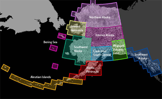

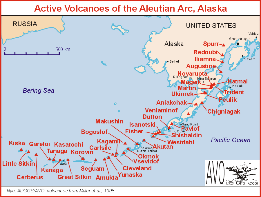


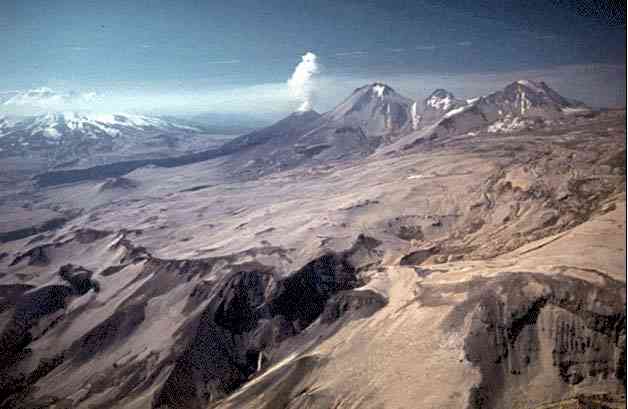


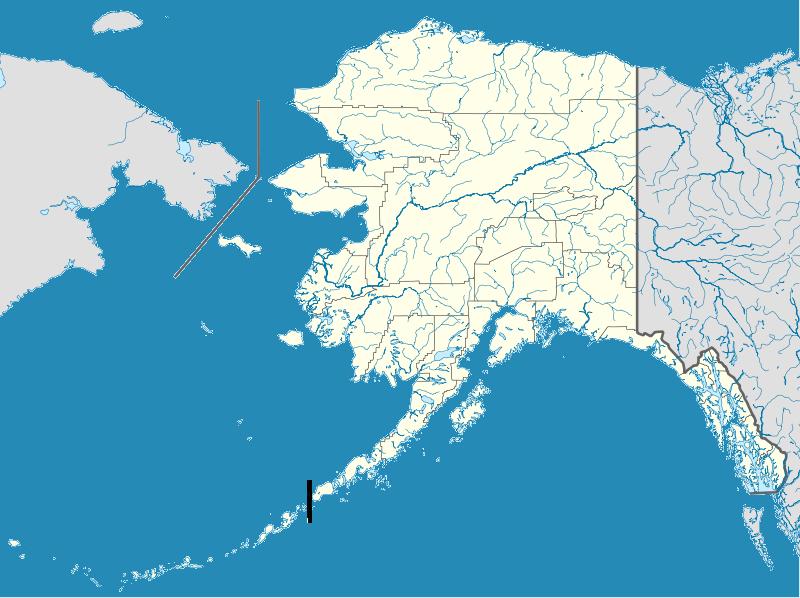

The Aleutian Range is a major mountain range of southwest Alaska, extending from Chakachamna Lake (130 km southwest of Anchorage) to Unimak Island, at the tip of the Alaska Peninsula. It includes all of the mountains of the Peninsula. It is especially notable for its large number of active volcanoes, which are also part of the larger Aleutian Arc. The mainland part of the range is about 1000 km long; the Aleutian Islands are (geologically) a partially submerged western extension of the range that stretches for another 1,600 km. However the official designation "Aleutian Range" includes only the mainland peaks and the peaks on Unimak Island.The range is almost entirely roadless wilderness, and Katmai National Park and Preserve, a large national park within the range, must be reached by boat or plane.The core Aleutian Range can be divided into three mountain groups. Listed from southwest to northeast, they are: Mountains of the Alaska Peninsula and Unimak Island, Chigmit Mountains, Neacola Mountains Aleutian Range http://en.wikipedia.org/wiki/Aleutian_Range
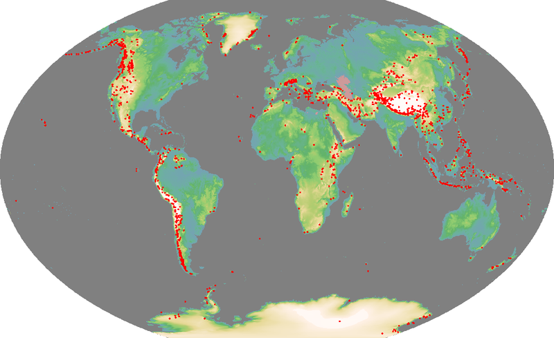
The Aleutian Arc is a large volcanic arc in the U.S. state of Alaska. It consists of a number of active and dormant volcanoes that have formed as a result of subduction along the Aleutian Trench. Although taking its name from the Aleutian Islands, this term is a geologic grouping rather than a geographic one, and the Aleutian Arc extends from the Alaska Peninsula to the Aleutian Islands.
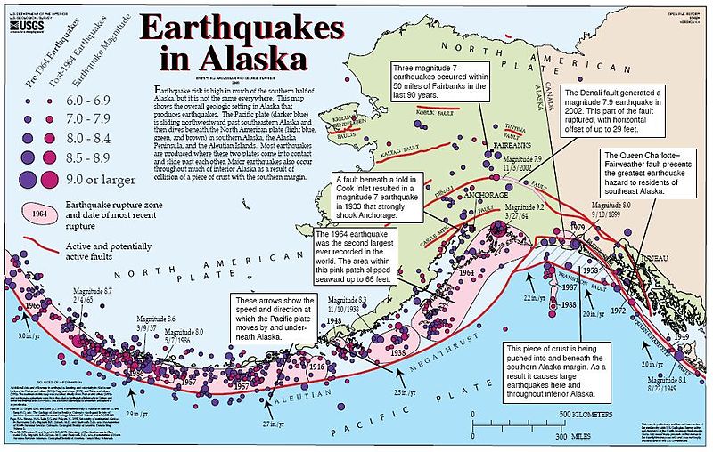
The Aleutian arc reflects subduction of the Pacific plate beneath the North American plate. It extends 3,000 km from the Kamchatka peninsula in the west to the Gulf of Alaska in the east. Unimak Pass at the southwestern end of the Alaska Peninsula marks the eastward transition from an intra-oceanic in the west to a continental arc in the east. Due to the arcuate geometry of the trench, the relative velocity vector changes from almost trench-normal in the Gulf of Alaska to almost trench-parallel in the west. Along the oceanic part of the subduction zone, convergence varies from 6.3 cm/yr to the NNW in the east to 7.4 cm/yr towards the NW in the west (DeMets and Dixon 1999) http://en.wikipedia.org/wiki/Aleutian_Arc
geology photos -http://alaska.usgs.gov/science/geology/images/photo_gallery.html