 | Geology south of TMVB |
The Canon del Sabino is a protected nature reserve in Oaxaca, Mexico.-http://www.karenmagid.com/2012/06/20/canon-del-sabino |
The Canon del Sabino is a protected nature reserve in Oaxaca, Mexico. |
The Canon del Sabino is a protected nature reserve in Oaxaca, Mexico. |
The Canon del Sabino is a protected nature reserve in Oaxaca, Mexico. |
The Canon del Sabino is a protected nature reserve in Oaxaca, Mexico. |
Tuxtla volcanic field. An aerial view from the SE shows pyroclastic cones on the flank of the massive San Martin Tuxtla volcano. More than 250 pyroclastic cones and maars dot the flanks of San MartĒn volcano. They are mostly located along a 40-km-long NW-trending zone parallel to the elongation of the massive shield volcano. Many clusters of cones are aligned in this same direction parallel to regional trends.Photo by Hugo Delgado-Granados, 1997 (Universidad Nacional Autonoma de Mexico) http://www.volcano.si.edu/world/volcano.cfm?vnum=1401-11=&volpage=photos |
Volcan San Martin, part of the Tuxtla volcanic field, is a broad alkaline shield volcano on the coast of the Gulf of Mexico. San Martin is elongated in a NW-SE direction. The summit and flanks of the 1650-m-high volcano are dotted with more than 250 pyroclastic cones and maars. The two largest historical eruptions took place in 1664 and 1793. The 1793 eruption occurred from two cinder cones in the 1-km-wide summit crater and produced widespread ashfall and lava flows that extended 3.5 km down the NE flank. Volcan de San Martin, part of the Tuxtla volcanic field, is a broad alkaline shield volcano that rises above the Gulf of Mexico. The massive volcano, also known as San Martin Tuxtla, is elongated in a NW-SE direction and is capped by a 1-km-wide summit crater. The upper part of the 1650-m-high volcano is covered with dense tropical rain forests. The summit and flanks of San Martin are dotted with more than 250 pyroclastic cones and maars. Well-preserved cinder cones are abundant between the summit of the volcano and Laguna Catemaco on the SE flank. Holocene cones in this area produced ash deposits that buried recently discovered stone pyramids. The two largest historical eruptions of San Martin took place in 1664 and 1793. The 1793 eruption occurred from two cinder cones in the summit crater and produced widespread ashfall and lava flows that extended 3.5 km down the NE flank. Photo by Steve Nelson, 1986 (Tulane University). http://www.geographic.org/photos/volcanoes/volcano_photos_257.html |
The Sierra de Los Tuxtlas (Tuxtlas Mountains, Tuxtla volcanic field with sam Martin ) are a volcanic belt and mountain range along the southeastern Veracruz Gulf coast in Eastern Mexico. The Los Tuxtlas Biosphere Reserve includes the coastal and higher elevations of the Sierra de Los Tuxtlas.The volcanic mountains were used as a basalt source. Peaks in this range include Volcano Santa Marta and Volcano San Martin Tuxtla, both rising above 1700 m. San Martin Tuxtla is the only recently active volcano in the belt, erupting in 1664 and again in May 1793. It is a broad alkaline shield volcano with a one km wide summit. Hundreds of smaller cinder cones are prevalent throughout the Sierra.Other, extinct volcanoes include San Martin Pajapan (1,160 m) and Cerro El Vigia (800 m).The Sierra de Los Tuxtlas volcanoes are an insular anomaly. The volcanoes are separated from the nearest volcano in the Trans-Mexican Volcanic Belt to the west by about 250 km, and from the Central American Volcanic Belt to the southeast by almost 330 km. The upper flanks of the San Martin Tuxtla and Santa Marta volcanoes are covered with the neotropical Sierra de los Tuxtlas tropical rainforest ecoregion, of the Tropical and subtropical moist broadleaf forests Biome. The lower portions are covered with stunted pastures and grasslands http://en.wikipedia.org/wiki/Sierra_de_los_Tuxtlas |
Chiapanecan Volcanic Arc. The Chiapanecan Volcanic Arc (CVA), located in the central portion of the State of Chiapas, is a 150 km stretch of volcanoes irregularly aligned in the northwest direction between two great volcanic features: the Trans-Mexican Volcanic Belt to the northwest and the Central American Volcanic Arc to the southeast. The CVA is located in a complex zone marking the interaction of the North American, Caribbean and Cocos plates, near the Motagua Polochic fault system, the boundary between North American and Caribbean plates. The central part of the CVA is composed of an irregular northwest alignment of at least 10 volcanic structures generally lying along NNW SSE-trending faults splayed from the Motagua Polochic system. Among the structures there are seven volcanic domes (Huitepec, Amahuitz, La Iglesia, MispЁЄa, La Lanza, Venustiano Carranza and SantotЁ«n), one explosion crater (Navenchauc), one collapse structure (Apas), and one dome complex (Tzontehuitz). In the majority of the structures there is a clear resurgence with the formation of several domes in the same structure, with the destruction of previous domes (Navenchauc) or with the formation of new explosion craters or collapse structures (Apas). The volcanic activity in the CVA was mainly effusive accompanied by explosive and phreatomagmatic events and is characterized by volcanic domes accompanied by block-and-ash-flows, ash flows with accretionary lapilli, falls, and pumice flows. The volcanic structures and deposits are calcalkaline in composition with a medium to high content of potassium. CVA volcanic rocks vary from andesite to dacite with SiO2 between 57 and 66 wt.%, show low concentrations of Ti, P, Nb and Ta, are enriched in Light Rare Earths, depleted in Heavy Rare Earths, and show a small Eu anomaly; all indicative of arc-related volcanism associated with subduction of the Cocos plate under the North American plate, but complicated by the geometry of the plate boundary fault systemhttp://adsabs.harvard.edu/abs/2007JVGR..162...43M, |
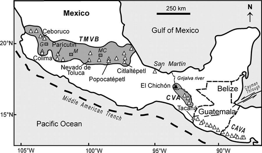
(A) Location map and tectonic setting of Southern Mexico (Modified from Tepley et al., 2000). (B) Map of the North America¢Caribbean plate boundary, west of the Motagua¢Polochic Fault System (map modified from Guzmбn-Speziale, 1985). (C) Location map of the Chiapanecan Volcanic Arc (CVA), and El Chichуn Volcano (ECV), Tacana Volcanic Complex (TVC), and study area. Abbreviations; CAVA, Central American Volcanic Arc; MPFS, Motagua¢Polochic Fault System; TMVB, Trans-Mexican Volcanic Belt.http://www.sciencedirect.com/science/article/pii/S0377027306004112 |
Map of the CVA central part -http://www.sciencedirect.com/science/article/pii/S0377027306004112 Geological Map of the central part of the Chiapanecan Volcanic Arc. The study zone cover an area of 4900 km2 and is composed by 10 volcanic structures: one collapse ctructure (Apas; ACS), one explosion crater (Navenchauc; NEC), dome complex (Tzontehuitz; TzDC) and seven volcanic domes (Huitepec, Amahuitz, La Iglesia, Mispнa, La Lanza, Venustiano Carranza and Santoton; |
http://www.tandfonline.com/doi/abs/10.1080/00206814.2012.683568#preview - Palaeomagnetic results from the Chiapanecan Volcanic Arc, Chiapas, Southern Mexico: geomagnetic and geodynamic significance. This article presents the first palaeomagnetic results from 13 independent cooling units in the Chiapanecan Volcanic Arc (ChVA). Six sites were directly dated by ArЁCAr or KЁCAr methods: their dates range from 2.14 to 0.23 Ma. We isolated the characteristic palaeodirections for all 13 lavas. Eleven non-transitional directions yield a mean direction with inclination, I = 30.7Ўг, declination, D = 4.1Ўг, and precision parameters k = 63 and ”Б95 = 5.8Ўг. The corresponding mean palaeopole position is Plat = 83.3Ўг, Plong = 203.8Ўг, K = 227, A 95 = 5.1Ўг. The mean inclination is in good agreement with the expected value for the last 5 million years, as derived from the synthetic North American polar wander path [Besse and Courtillot 2002 3. Besse , J. and Courtillot , V. 2002 . Apparent and true polar wander and the geometry of the magnetic field in the last 200 million years . Journal of Geophysical Research , 107 ( B11 ) doi: 10.1029/2000JB000050 . Apparent and true polar wander and the geometry of the magnetic field in the last 200 million years: Journal of Geophysical Research, v. 107, no. B11, p. 2300], but a measured rotation of the palaeodeclination of about 8Ўг with respect to the expected direction suggests the possibility of a clockwise rotation of the studied ChVA units. We have estimated the characteristics of palaeosecular variation through study of the scatter of virtual geomagnetic poles, obtaining a palaeosecular variation parameter S b = 14.5Ўг with upper limit S U = 19.6Ўг and lower limit S L = 11.7Ўг, in reasonable agreement with the fit of model G [McFadden et al., 198838. Quidelleur , X. , Carlut , J. , Gillot , P.Y. and Soler , V. 2002 . Evolution of the geomagnetic field prior to the Matuyama-Brunhes transition: Radiometric dating of a 820 ka excursion at La Palma . Geophysical Journal International , 151 : F6 ЁC F10 . Dipole/quadrupole family modeling of paleosecular variation: Journal of Geophysical Research, v. 93, no. B10, p. 11583ЁC11588; 1991, Reversals of the Earth''s magnetic field and temporal variations of the dynamo families: Journal of Geophysical Research, v. 96, no. B3, p. 3923ЁC3933] to the Johnson et al. [200822. Johnson , C.L. , Constable , C.G. , Tauxe , L. , Barendregt , R. , Brown , L.L. , Coe , R.S. , Layer , P. , Mejia , V. , Opdyke , N.D. , Singer , B.S. , Staudigel , H. and Stone , D.B. 2008 . Recent investigations of the 0ЁC5 Ma geomagnetic field recorded by lava flows . Geochemistry, Geophysics, Geosystems , 9 ( 4 ) doi: 10.1029/2007GC001696 Recent investigations of the 0ЁC5 Ma geomagnetic field recorded by lava flows: Geochemistry, Geophysics, Geosystems, v. 9, no. 4, ID Q04032, doi:10.1029/2007GC001696] databases for the last 5 million years. In those cases in which age determinations are available, the polarity obtained for the studied flows is consistent with their stratigraphic positions, except for the Huitepec site, which probably reflects the transitional geomagnetic regime prior to the MatuyamaЁCBrunhes geomagnetic reversal |
Amahuitz Volcanic Dome (AVD). (A) Panoramic photograph of the AVD. (B) Fall deposit in the village of Teopisca. The CVA is located in a complex zone marking the interaction of the North American, Caribbean and Cocos plates, near the Motagua¢Polochic fault system, the boundary between North American and Caribbean plates. The central part of the CVA is composed of an irregular northwest alignment of at least 10 volcanic structures generally lying along NNW¢SSE-trending faults splayed from the Motagua¢Polochic system. Among the structures there are seven volcanic domes (Huitepec, Amahuitz, La Iglesia, Mispнa, La Lanza, Venustiano Carranza and Santotуn), one explosion crater (Navenchauc), one collapse structure (Apas), and one dome complex (Tzontehuitz). In the majority of the structures there is a clear resurgence with the formation of several domes in the same structure, with the destruction of previous domes (Navenchauc) or with the formation of new explosion craters or collapse structures (Apas). The volcanic activity in the CVA was mainly effusive accompanied by explosive and phreatomagmatic events and is characterized by volcanic domes accompanied by block-and-ash-flows, ash flows with accretionary lapilli, falls, and pumice flows. The volcanic structures and deposits are calcalkaline in composition with a medium to high content of potassium. CVA volcanic rocks vary from andesite to dacite with SiO2 between 57 and 66 wt.%, show low concentrations of Ti, P, Nb and Ta, are enriched in Light Rare Earths, depleted in Heavy Rare Earths, and show a small Eu anomaly; all indicative of arc-related volcanism associated with subduction of the Cocos plate under the North American plate, but complicated by the geometry of the plate boundary fault systemhttp://www.sciencedirect.com/science/article/pii/S0377027306004112 |
The pre-1982 summit of El Chichon volcano is seen in this aerial view from the east. A large lava dome that formed the previous summit of the volcano fills a 1.6 x 2 km wide central crater that was created about 220,000 years ago. This dome was destroyed by the 1982 eruptions, which created a new 1-km-wide crater centered on the former dome. The two forested peaks outside the older crater are the SW (upper left) and NW (upper right) lava domes.Photo by Rene Canul, 1981 (Comisiуn Federal de Electricidad). http://www.volcano.si.edu/world/volcano.cfm?vnum=1401-12=&volpage=photos |
An incandescent pyroclastic flow (lower right) travels down the flanks of the volcano as lightning bolts accompany an eruption plume (center) from El Chichуn on April 3, 1982. Minutes later this eruption column reached a height of about 24 km. The ejection of large amounts of incandescent tephra and pryoclastic flows and surges caused extensive damage and fatalities. Explosive removal of the summit lava dome created a new 1-km-wide, 300-m-deep crater. Photo by Servando De la Cruz-Reyna, 1982 (Universidad Nacional Autonoma de Mexico) http://www.volcano.si.edu/world/volcano.cfm?vnum=1401-12=&volpage=photos |
Steam pours from the new crater of El Chichon volcano in June 1982, about two months after the formation of the crater during a major explosive eruption. When the crater was first seen after the eruption on April 25, three small lakes were observed on the crater floor. These merged into a single lake that reached a maximum depth of about 120 m. This aerial view from the east also shows erosional gullying of pyroclastic-flow and -surge deposits in the foreground on the outer flanks of the crater.Photo by Wendell Duffield, 1982 (U.S. Geological Survey, http://www.volcano.si.edu/world/volcano.cfm?vnum=1401-12=&volpage=photos |
Billowing white steam plumes pour from fumaroles on the crater floor of El Chichуn volcano in January 1983. Small puffs of steam also rise from the hot, acidic crater lake in the foreground. Temperatures of fumaroles on the crater floor and lower crater walls at this time ranged from 98 to 115░ C. Photo by Bill Rose, 1983 (Michigan Technological University).http://www.volcano.si.edu/world/volcano.cfm?vnum=1401-12=&volpage=photos http://www.volcano.si.edu/world/volcano.cfm?vnum=1401-12=&volpage=var |
The steaming crater of El Chichon volcano is seen here in January 1983, less than a year after a major explosive eruption formed a new 1-km-wide crater that later was partially filled by a steaming, acidic lake. The isolated El Chichуn volcano is a small, but powerful andesitic tuff cone and lava dome complex. Prior to 1982, this relatively unknown volcano was heavily forested and of no greater height than adjacent non-volcanic peaks. More than a half dozen large explosive eruptions have occurred since the mid-Holocene. http://www.volcano.si.edu/world/volcano.cfm?vnum=1401-12=&volpage=photos Photo by Bill Rose, 1983 (Michigan Technological University). |
El Chichon, 17.33 N, 93.20 W, summit elevation 1060 m, lava domes. El Chichon is an andesite stratovolcano of Quaternary age situated in forested terrain of north-central Chiapas, Mexico. It is the youngest volcano in the northwestern part of the 150-km-long Chiapanecan volcanic arc.El Chichon volcano has produced at least 12 major volcanic eruptions during the past 8000 years. The volcano displays a recurrence interval of 300 years on average, with a range from a minimum of 100 yr to a maximum of 600 yr.The nearest cities of substantial size are Villahermosa, 80 km to the north northeast, and Tuxtla Gutierrez, 70 km to the south-southeast. The nearest neighboring Holocene volcanoes are about 275 km and 200 km to the southeast and northwest, respectively. El Chichon Volcano erupted on 28th March 1982 after several months of increased seismic activity. This was the first historical eruption at the volcano. From 29th March to 4th April 1982 three large explosive eruptions occurred at El Chichon volcano. The 1982 eruptions produced a 1 km wide crater which now contains a lake. Nearly all of the pre-1982 summit dome was destroyed during the eruptions, and created a 1 km wide and 300 m deep crater in its place. A crater lake formed in the 1km wide crater of El Chich¦еn volcano after the 1982 eruption. The crater lake formed during the JuneЁCNovember 1982 rainy season. The lake is very shallow, with a depth of 1-3 m. It is essentially a large steam-heated pool, where the acidity is provided by the oxidation of hydrogen sulphide. The lake has a pH 2.2 and temperature of 30 deg C. 1930 Fumarolic Activity. El Chichon Volcano was climbed by Friedrich Mullerried in 1930 and noted the presence of vigorous fumaroles, solfataras and hot springs. He speculated that El Chichon might erupt in the future because of fumarolic activity and earthquakes. Eruptions 1360 +/- 100 years, 1190 +/- 150, 780 AD +/- 150, 590 AD +/- 100, 480 AD +/- 200, 190 AD +/- 150, 20 BC +/- 50, 700 BC +/- 200, 1340 BC +/- 150, 2030 BC +/- 100, 6510 BC +/- 75. http://www.volcanolive.com/elchichon.html Turquoise-colored crater lake in January 1983, during the first visit to the crater following the major March-April 1982 explosive eruption. The new lake had grown by November 1982 to a depth of about 120 m, after which lake level dropped slightly. In January 1983 the lake was hot (52-58░ C) and acidic (pH of 0.5). By October 1983 the temperature had dropped to 42░ C and the pH was 1.8. http://www.volcano.si.edu/world/volcano.cfm?vnum=1401-12=&volpage=photos |
El Chichonal . El Chichonal is an active volcano in Francisco Leon Municipality. Its only recorded eruptive activity was on March 29, April 3 and April 4, 1982, when it produced a one km-wide caldera that then filled with an acidic crater lake. It had high-sulfur anhydrite-bearing magma, explosive eruptions, pyroclastic flows, and surges that were devastating to the area surrounding the volcano.In 2000, the lake''s water temperature increased. Also, the lake acquired a blue-green color, due to massive amounts of dissolved minerals in the acidic water, and fine, light-colored ashy sediment continually stirred up by boiling areas.El Chichon is part of a geologic zone known as the Chiapanecan Volcanic Arc. This volcanic region is thought to be the result of the subduction of the Tehuantepec Ridge, an undersea ridge which lies on the Cocos Plate off the Pacific coast of Mexico- http://en.wikipedia.org/wiki/El_Chich%C3%B3n |
Aerial view on 1982-11-04, seven months after the eruption of El Chichon. |
The east rim of the 1982 crater at El Chichуn is seen here from the rim of the larger somma crater. Erosional gulleys dissect pyroclastic-flow and -surge deposits that swept radially away from the 1982 crater. The rim here rises about 50 m above the moat between the two craters. Prior to the 1982 eruption a lava dome rose several hundred meters above the crater floor.Photo by Bill Rose, 1983 (Michigan Technological University).http://www.volcano.si.edu/world/volcano.cfm?vnum=1401-12=&volpage=photos |
Pyroclastic surges completely devastated vegetation on the flanks of El Chichon volcano to distances up to 8 km from the crater. Still-steaming pyroclastic-flow and -surge deposits are seen in this early April photo at Francisco Leуn, 5 km SSW of the crater. Three major pyroclastic flows swept the flanks of the volcano on April 3 and 4, devasting an area of 154 sq km; all three surges reached Francisco Leуn. Pyroclastic surges swept over ridges as high as 300 m and left sharp trimlines at their margins.Photo by Servando De la Cruz-Reyna, 1982 (Universidad Nacional Autуnoma de Mexico) http://www.volcano.si.edu/world/volcano.cfm?vnum=1401-12=&volpage=photos |
Major pyroclastic-flow deposits of the April 3 and 4 El Chichon eruptions formed natural dams blocking the Magdalena-Ostuacan river. The tephra dam seen here, located about 4.5 km WSW of the crater, produced a lake that eventually reached 5 km in length and had a volume of several million cubic meters. It failed catastrophically about 7 weeks after the end of the eruption (May 26), causing a massive lahar with temperatures to 82░ C Photo by Servando De la Cruz-Reyna, 1982 (Universidad Nacional Autуnoma de Mexico).http://www.volcano.si.edu/world/volcano.cfm?vnum=1401-12=&volpage=photos |
Windblown ash obscures soldiers searching the town of El Naranjo, 7.5 km south of the crater, a few days after the end of the eruption. Among the several thousand deaths caused by the eruption were one geologist and 32 soldiers sent to the village of Francisco Leуn, ~ 6 km SW of the summit, after the March 28-29 explosion. The pyroclastic flow that traveled through Francisco Leуn left only a thin deposit, but of the structures in the village, only one wall of the church, parallel to the direction of the pyroclastic flow''s movement, remained standing. Photo by Servando De la Cruz-Reyna, 1982 (Universidad Nacional Autonoma de Mexico).http://www.volcano.si.edu/world/volcano.cfm?vnum=1401-12=&volpage=photos |
Ashfall deposits, such as seen here near Villahermosa north of the volcano, whitened the landscape around El Chichуn like snow and stripped many trees of their leaves. Ashfall deposits trending to the ENE blanketed an area of 45,000 sq km within the 1 mm isopach. Eruption columns on March 28-29 and April 3-4 reached 17 km or higher. The exceptionally high sulfur content of the El Chichуn magma produced an eruptive plume rich in sulfuric acid aerosols, which circled the globe in three weeks and led to warming of the stratosphere.Photo by Servando De la Cruz-Reyna, 1982 (Universidad Nacional Autonoma de Mexico) http://www.volcano.si.edu/world/volcano.cfm?vnum=1401-12=&volpage=photos |
The terminus of a pyroclastic-flow lobe about 4 km NE of the crater, south of Nicapa, is seen within a day or two of its emplacement on April 4, 1982. The Nicapa valley was the site of the most extensive pyroclastic flows of the 1982 eruption. Up to three units, each 2-15 m thick and containing abundant pumice blocks 15-40 cm in diameter, are present. Light-colored ash from the April 4 pyroclastic surges covers a broad radial area around the crater to distances 1.5 km beyond the extent of the pyroclastic flows in the Nicapa valley Photo by Servando De la Cruz-Reyna, 1982 (Universidad Nacional Autonoma de Mexico) http://www.volcano.si.edu/world/volcano.cfm?vnum=1401-12=&volpage=photos |
A) Location map of the El Chichon volcano in southern Mexico that shows main tectonic and volcanic features. Abbreviations are: CVA = Chiapanecan Volcanic Arc, and CAVA = Central America Volcanic Arc. B) Landsat image (Bands 3, 5 and 7 as R, G and B, respectively), acquired in 1986 showing El Chichуn volcano, rivers, and main cities and towns. The image displays the course of the El Platanar and Magdalena rivers that are tributaries of the perennial Grijalva River. Notice in pink post-1982 lahar deposits along these rivers. The white dashed line represents the 30-cm isopach of the 1982 A1 fallout, and the 550 yr BP Plinian fall deposit and , and the solid white line marks the extent of the pyroclastic surge deposits and associated fallouts (Scolamacchia and Macias, 2005). http://www.sciencedirect.com/science/article/pii/S0377027308001650 |
El Chichon volcanic complex -http://www.scielo.org.mx/scielo.php?pid=S0016-71692009000100004&script=sci_arttext |
The Chiapanecan Volcanic Arc (CVA), Mispia Volcanic Dome (MVD). (A) Panoramic photograph of the MVD. (B) Photograph of brown block-and-ash-flow deposits, with semi-compact structure and gray blocks. Surrounding the blocks there is a fine and medium in size sand matrix, composed by glass, crystals and lithics. (C) Panoramic photograph looking to the south of the MVD, where there is the distribution of dome, block-and-ash-flow deposit and sedimentary basement - http://www.sciencedirect.com/science/article/pii/S0377027306004112 |
CVA. La Lanza Volcanic Dome (LVD). (A) Panoramic photograph of the LVD. White lines delimit the block-and-ash-flow and sedimentary deposits surrounding this volcanic structure. (B) Photograph of one block from the block-and-ash-flow deposit surrounding La Lanza - http://www.sciencedirect.com/science/article/pii/S0377027306004112 |
CVA La Iglesia Volcanic Dome (IVD). (A) Panoramic photograph of the IVD. (B) Photographs of gray block-and-ash-flow deposit with a semi-compact and massive structure; the blocks are surrounded by a matrix of fine to medium size sand -http://www.sciencedirect.com/science/article/pii/S0377027306004112 |
CVA. Navenchauc Explosion Crater (NEC), Navenchauc Dome, and Volcanic Deposits. (A) Panoramic photograph looking to the north of the NEC, The village of Navenchauc lies along a lake in front of the dome. The white line delineates the diffuse contact between dome rocks and carbonate rock. (B) Photograph of an approximately 35 m high vertical dome wall. (C) Ash flow deposit from the NEC located along the NW caldera wall. (D) Photograph of detail of the ash flow deposits with accretionary lapilli- http://www.sciencedirect.com/science/article/pii/S0377027306004112 |
CVA.Huitepec Volcanic Dome. (A) Panoramic photograph showing the HVD from San Cristobal de las Casas. (B) Outcrop of ash flow deposits associated with the HVD - http://www.sciencedirect.com/science/article/pii/S0377027306004112 |
CVA. Apas Collapse Structure (ACS) volcanic deposits. (A) Discordant contact between ash flow deposit and limestone from the basement sequence rocks. (B) Outcrop of the medium part of the Apas Volcanic Sequence. (C) One outcrop of block-and-ash-flow deposit along the fan to the south of the ACS. (D) Outcrop of the block-and-ash-flow deposit in the south of the ACS, in the fan area -http://www.sciencedirect.com/science/article/pii/S0377027306004112 |
Santoton Volcanic Dome (SVD) -http://www.sciencedirect.com/science/article/pii/S0377027306004112 |
(A) Panoramic photograph looking to the north of the Venustiano Carranza Volcanic Dome. The white line indicates the division between the volcanic structure and the volcanic deposits. (B) Photograph of block-and-ash-flow deposit -http://www.sciencedirect.com/science/article/pii/S0377027306004112 |
Tzontehuitz Dome Complex. (A) Panoramic photograph showing the TzDC (Tzontehuitz 1). (B) Photograph of Calvario Dome and gray rocks of its structure http://www.sciencedirect.com/science/article/pii/S0377027306004112 |
Middle Miocene Chiapas fold and thrust belt of Mexico: a result of collision of the Tehuantepec Transform/Ridge with the Middle America Trench. The Middle Miocene, thin-skinned, Chiapas fold-and-thrust belt (Gulf of Mexico¢southeastern Mexico¢Belize) consists of WNW-trending folds and thrusts, and East¢West sinistral transcurrent faults resulting from N60░E shortening. Balanced cross-sections indicate that shortening varies from 48% (SW) to c. 8% (NE) with a total shortening of 106 km, and that thrusts merge into a basal dйcollement in the Callovian salt horizon. The Middle Miocene age of the deformation is synchronous with collision of the Tehuantepec Transform/Ridge with the Middle America Trench off Chiapas. The presently exposed Tehuantepec Transform/Ridge varies from a transform fault across which the age of the oceanic crust changes producing a step (down to the east) to a ridge resulting from compression following a change in plate motion and a series of seamounts. On the other hand, the earthquake data show that the part of the Tehuantepec Transform/Ridge subducted during the past 5 Ma is a step with no accompanying ridge. Whereas collision of a ridge segment with the trench is inferred to be responsible for the 13¢11 Ma deformation in the upper plate, its termination at 11 Ma suggests an along-strike transition to a step. Collision of the Tehuantepec Transform/Ridge also appears to have terminated arc magmatism along the Pacific coast of Chiapas. The similarity between the petroleum-producing, Cantarell structure in the Sonda de Campeche and the buried foldbelt in the Sierra de Chiapas suggests there is considerable further hydrocarbon potential - http://sp.lyellcollection.org/content/327/1/55.abstract |


Res.Master of Geosciences (M.Gsc.), Master of Science Degree in Geology, The Master of Science in Geology offers a solid formation combining fundamental science with applied skills and covers most orientations of Earth Sciences, field studies and cooperates with academic, research and industrial partners. Orientations: Ore deposits and geologic ingineering. The Master of Geoscience (M.Gsc.) is designed for a broad background in the Geosciences at the graduate level., Geology and Geophysics Department. Master of Science in Applied Geosciences ЁC Geology Masters Program. Master of Science in Applied Geosciences ЁC Geophysics Masters Program. A master of applied geosciences isnЎЇt just a master of geology degree; it combines expertise in the theoretical areas of geology with technical expertise in geochemistry, geophysics, and engineering. M.Gsc.Master of Science in both Geology and Geophysics. ЁC Master of Geophysics degree program. Potential Field Methods of Geophysical Exploration, Geophysical Data Processing, Seismic Wave and Ray Theory, Rock Physics Experience. Ph.D. program
Exploration and production geologists and geophysicists
A strong fundamental background in the earth sciences, physical sciences, mathematics, petroleum science and technology. Several shor t-term careers.
Researchers
Geoscience careers with basic and applied research in seeking new ways to find and recover petroleum supplies. My research reflect exploration and production business strategies; for example, pursuing attractive exploration opportunities, developing production from new fields, and maximizing economic recovery from existing fields.
Career Path
offer a diverse array of career opportunities in a petroleum exploration and geological theoryt. My Research organization offers the opportunity to perform research in seeking new ways to find and recover petroleum supplies. A wide array of opportunities exist in both generalist and specialist positions.
The Department of Earth Sciences at the University of Saint Petersburg, Russia. a rigorous foundation in either Geophysics or Geology are designed to meet the rapidly growing demand in industry for highly-trained applied geophysicists and geologists for Mine and Energy Resource Geology and for the forefront of Earth Sciences across a broad range of applied Earth Science disciplines.
Shool Grade Point Average (GPA), Graduate Record Exams (GRE) scores.
Chiapanecan Volcanic Arc. Tehuantepec Ridge,
http://www.mnh.si.edu/earth/text/dynamicearth/6_0_0_geogallery/geogallery_browse.cfm?categoryID=5&browseType=volcanoname&volcanoName=Telica
http://www.mnh.si.edu/earth/text/dynamicearth/6_0_0_geogallery/geogallery_drilldown.cfm?categoryID=5
http://www.mnh.si.edu/earth/text/dynamicearth/6_0_0_geogallery/geogallery_drilldown.cfm?categoryID=5 volcanology
http://www.volcanolive.com/mexico.html
http://climber.org/reports/2001/741.html - baja
http://www.volcanolive.com/humeros.html l as humeras tmb
http://en.wikipedia.org/wiki/List_of_volcanoes_in_Mexico list of volcanoes
http://en.wikipedia.org/wiki/El_Chich%C3%B3n chichonol center
http://manxodoarte.blogspot.com/2012/06/volcanes-de-mexico.html
http://vulcan.wr.usgs.gov/Volcanoes/Mexico/framework.html
http://www.volcano.si.edu/world/volcano.cfm?vnum=1401-11= de san martin gulf
http://en.wikipedia.org/wiki/Mountain_peaks_of_Mexico
El Chichonal - http://en.wikipedia.org/wiki/El_Chich%C3%B3n ug
Cerro la Joya Cerro Colorado Toxtlacuaya lava flow
--
El Portero Chico http://en.wikipedia.org/wiki/Potrero_Chico,colorado
http://climber.org/reports/2001/741.html
http://schubabala.wordpress.com/ http://www.volcanolive.com/mexico.html
Canon de Sabino near town Tehuacan
Volc¦Тn deTequila w cntr
Ceboruco volcano
http://www.municipiodenogales.org/English/geology/sonora_evolution.htm Evolution of the Sonora Coast The following movie shows all of this process, reconstructing the last 36 million years: The separation and emigration of the Lower California Peninsula (Baja California), the birth of the Gulf of California, and the "stretching" of Sonora in a direction East ЁC West
El Portero Chico http://en.wikipedia.org/wiki/Potrero_Chico,colorado
http://climber.org/reports/2001/741.html
http://schubabala.wordpress.com/ http://www.volcanolive.com/mexico.html
Canon de Sabino near town Tehuacan
Volc¦Тn deTequila w cntr
Ceboruco volcano
TMVB
MODERN CHIAPANECAN VOLCANIC ARC CVA
TILZAPOTLA-BUENAVISTA CALDERA AND Zapalco¢Amacuzac area
New 40Ar/39Ar ages from the Central Part of the Chiapanecan Volcanic Arc
Geology of Mexico