 | Michoacan-Guanajuato volcanic field |
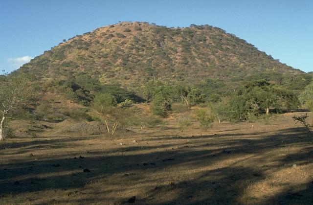
El Jorullo, 1,330 m, cinder cone, last eruption 1759¢1774 is in Michoacan, central Mexico, on the southwest slope of the central plateau, 53 km southeast of Uruapan in an area known as the Michoacan-Guanajuato volcanic field. Coordinates are (18.974008N, −101.717492W). Its current elevation is 1,320 m. El Jorullo has four smaller cinder cones which have grown from its flanks. The vents of El Jorullo are aligned in a northeast to southwest direction. Lava from these vents cover nine square km around the volcano. Later eruptions produced lavas that had higher silica contents making them thicker than the earlier basalts and basaltic andesite lavas. El Jorullo''s crater is about 400 by 500 m wide and 150 m deep. El Jorullo is one of two known volcanoes to have developed in Mexico in recent history. The second, born about 183 years later, was named Paricutin after a nearby village that it eventually destroyed. Paricutin is about 80 km northwest of El Jorullo. El Jorullo was born on 29 September 1759. Earthquakes occurred prior to this first day of eruption. Once the volcano started erupting, it continued for 15 years...eventually ending in 1774. El Jorullo didnÆt develop on a corn field like Paricutin did, but it did destroy what had been a rich agricultural area. It grew approximately 250 m from the ground in the first six weeks. The eruptions from El Jorullo were primarily phreatic and phreatomagmatic. They covered the area with sticky mud flows, water flows and ash falls. All but the youngest lava flows were covered by this ash fall. Later eruptions from El Jorullo were magmatic with neither mud nor water flows. This 15 year eruption was the longest one El Jorullo has had, and was the longest cinder cone eruption known. Lava flows can still be seen to the north and west of the volcano. The eruption had a VEI of 4.Paricutin and El Jorullo both rose in an area known for its volcanoes. Called the Trans-Mexican Volcanic Belt, the region stretches about 1,120 km from east to west across southern Mexico. Geologists say that eruptive activity deposited a layer of volcanic rock some 2,000 m thick, creating a high and fertile plateau. During summer months, the heights snag moisture-laden breezes from the Pacific Ocean; rich farmland, in turn, has made this belt the most populous region in Mexico. Though the region already boasted three of the country''s four largest cities: Mexico City, Puebla, and Guadalajara (the area around Paricutin, it was still a peaceful backwater inhabited by Tarascan Indians in the early 1940s. http://en.wikipedia.org/wiki/Jorullo |
Paricutin cinder cone and the Cerro de Tancitaro shield volcano |
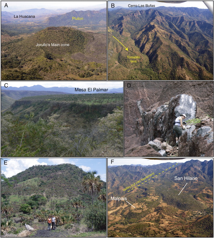
Ģ Jorullo Photographs of formations cropping out around Jorullo. (A) Aerial view from the east of the ca. 250 m-high Jorullo''s Main cone. Eroded hills in the background to the right are formed by Oligocene granodiorites (Pluton on picture). (B) Aerial view from above the Jorullo distal lavas, looking north. These high cliffs that culminate at Cerro Las Bufas expose hydrothermally-altered Tertiary volcanics of difficult access. (C) View over the andesitic Mesa El Palmar (1.03 Ma) from a roadside stop along the western border of the plutonic hill located north of La Huacana. (D) View of a ca. 1 m-wide finely-vesicular basaltic dike that cuts through the interior of C. El Banco 2 (1.06 Ma, Carmichael et al., 2006). Note the gradual lateral change in dip of the dike. (E) Roadside view of La Pilita cone (0.102 Ma, Carmichael et al., 2006) that produced basaltic andesites to basaltic trachyandesite lavas. (F) Aerial view of Pleistocene to Holocene San Hilario (to the right) and Malpais (to the left) lava flows. The vents of these flows formed along a prominent northeast-oriented valley cut into the basement. |
Michoacan-Guanajuato is a volcano field in central Mexico that takes the form of a large cinder cone field. The field also has numerous shield volcanoes and maars. The volcano is best known for its Jorullo and Paricutin Cinder Cones, which erupted in 1759-1774 and 1943-1952. The volcano field covers an area of 200 x 250 km. The volcano covers areas of both the Michoacßn and Guanajuato states. The volcano contains 1400 vents, mostly cinder cones. The shield volcanoes are mostly Pleistocene in age. The cinder cones are randomly arranged and occur at low altitudes, usually on alluvial plains or on the flanks of eroded shield volcanoes. There are an average of 2.5 cinder cones every 100 km2.
Jorullo 1759-1774 eruption
El Jorullo was born on September 29, 1759. Earthquakes occurred prior to this first day of eruption. Once the cinder cone started erupting, it continued for 15 years...eventually ending in 1774. El Jorullo didnÆt develop on a corn field like Paricutin did, but it did destroy what had been a rich agricultural area. It grew approximately 250 m from the ground in the first six weeks. The eruptions from El Jorullo were primarily phreatic and phreatomagmatic. They covered the area with sticky mud flows, water flows and ash falls. All but the youngest lava flows were covered by this ash fall. Later eruptions from El Jorullo were magmatic with neither mud nor water flows. This 15 year eruption was the longest one El Jorullo has had, and was the longest cinder cone eruption known. Lava flows can still be seen to the north and west of the cinder cone. The eruption had a VEI of 4. Its current elevation is 1,320 m. El Jorullo has four smaller cinder cones which have grown from its flanks. The vents of El Jorullo are aligned in a northeast to southwest direction. Lava from these vents cover nine km2 around the volcano. Later eruptions produced lavas that had higher silica contents making them more viscous than the earlier basalts and basaltic andesite lavas. El Jorullo''s crater is about 400 by 500 m wide and 150 m deep.
Paricutin 1943-1952 Eruption
At the end of this phase, after roughly one year, the cinder cone had grown 336 m tall. For the next eight years the volcano would continue erupting, although this was dominated by relatively quiet eruptions of lava that would scorch the surrounding 25 km▓ of land. The cinder cone''s activity would slowly decline during this period until the last six months of the eruption, during which violent and explosive activity was frequent. In 1952 the eruption ended and Paricutin went quiet, attaining a final height of 424 m from the cornfield where it began. Like most cinder cones, Paricutin is believed to be a monogenetic volcano, which means that once it has finished erupting, it will never erupt again. Any new eruptions in the volcanic field will erupt in a new location. http://en.wikipedia.org/wiki/Jorullo
Geology, geochronology, and tectonic setting of the Jorullo Volcano region, Michoacan, Mexico. The Jorullo monogenetic volcano erupted 250 years ago at the southern border of the Trans-Mexican Volcanic Belt (TMVB), an area that records a long history of magmatic and tectonic activity. The oldest rocks that crop out in the area are early-Oligocene (32.7 +/_ 0.2 Ma) dioritic to granitic (60¢72 wt.% SiO2) plutons intruded by younger to contemporaneous (30.3+/_ 0.1 and 33.3 +/_ 0.7 Ma) aplitic (76¢78 wt.% SiO2) dikes and mineralized veins. Volcanic rocks related to these intrusives form a thick sequence exposed in cliffs, from the base of which an altered andesite (58 wt.% SiO2) was collected. The nearby epithermal Cu-mineralization of the Inguarán mining area to the southeast is also related to this Tertiary volcanic episode. The oldest expression of the TMVB in this area is represented by Pliocene (3.2¢2.4 Ma) basaltic andesite to andesite (53¢63 wt.% SiO2) lavas (with pyroxene ▒ olivine) forming extensive mesas, eroded mounds, and thick elongate flows, that were unconformably deposited on top of the Oligocene rocks. Their emplacement was followed by erosion approximating a rate of 100 m/Ma over the past 3 Ma. This led to the formation of an inverted topography reflecting the higher resistance to erosion of these lavas that were originally deposited in valleys and today constitute prominent mesas. During the last 1 Ma, at least twenty-six monogenetic scoria cones formed in the study area, erupting about 10.2 km3 of lava and pyroclastics dominantly composed of olivine and pyroxene-bearing andesites (61 vol.% DRE), lesser basaltic andesites (30 vol.% DRE), and a minority of olivine-rich basalts (10 vol.% DRE). These eruptive products include the K-rich basaltic trachyandesites of Cerro La Pilita, a scoria and lava cone located close to Jorullo. The < 27 ka San Hilario and Esmeralda lavas, which are located 13 km southeast of Jorullo, are the southernmost eruptive products of the TMVB and also the youngest volcanoes after Jorullo in this area. Mapping of main faults and scoria cone alignments on regional and local scales reveals that the ascent of dikes feeding Quaternary eruptions in the Jorullo area was controlled by west-northwest and west-southwest basement structures, northeast-oriented subduction-related horizontal compressional stress probably associated with crustal fractures, and a major northwest-trending seismically active fault zone that passes near Paricutin and Jorullo. Oldest rocks are strongly-faulted Eocene volcanic sequence and Oligocene plutons. First TMVB products are voluminous Pliocene andesitic lavas forming elevated mesas. > 26 monogenetic eruptions of 10.2 km3 of mainly-andesitic magma during last 1 Ma. Control by pre-existing structures, seismically-active faults and regional stress. Keywords: monogenetic; scoria cone; Trans-Mexican Volcanic Belt; radiometric datinghttp://www.sciencedirect.com/science/article/pii/S0377027310002933